
General information on the travel report.
Travelogue GTA-North Great Crossing of the Alps
GrandeTraversata delle Alpi
(Passo Novena/Nufenenpass – Susa)
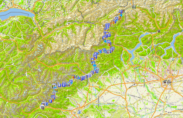
GTA North
Countries: Italy and a small part of Switzerland
Region: Piedmont, Wallis
Route: Nufenenpass (Passo Novena, Airolo, Switzerland)
Period: 17/08/12 to 16/09/12 (Revisited 2019: see text)
Travel company: solo
Public transport:
Outward trip (2019):
- Zaventem – Milano Malpensa with Ryanair baggage (10kg – 6€ and reserved seat (6€).
- Milano Malpensa – Airolo (30€)
Return trip (2012):
- Meana di Susa – Torino (train 4,30€)
- Torino – Milan (train 11,20€)
- Milan – Bus station (metro 1,50€)
- Milan – Brussels (Flixbus 62€)
Possible alternative:
- Meana di Susa – Torino (train 4,30€)
- Torino – Milan (train 11,20€)
- Milan – Milan Malpensa (Buses each hour left of the railway station, at the Piazza Luigi di Savoia)
- Milan – Zaventem (Brussels Airlines or Ryanair)
Accommodation:
- Cabins owned by the CAI (Club Alpino Italiano) (Half board: 56€ for members of an alpine club.
- Posto Tappa to Hotels elsewhere from 50 to 120€ in a room or in a dorm, including half-board.
- Switzerland: 90 CHF for 1 person in a room with breakfast:
Travel costs (2019):
- 1l of wine: 6 to 10€ € (Attention in Switzerland; 3 CHF for 1dl!!!!!)
- Spaghetti: 4 to 8€
- Pizza: 4,5 to 10€ (Switzerland 12 to 20 CHF)
- Mineral water 1L: 1,50 to 2€ (Two huts report that their water does not meet government standards to be classified as drinking water. In practice, it doesn’t kill you or even makes you sick.)
Total travel budget: 1400€
Payment methods:
- Cash
- ATM (Attention: only available in the slightly larger places in the valleys, see travel report)
- Visa (Attention, difficult to accept, given the small amounts.)
- Cash withdrawal with Visa Expensive!!!!!.
Travel literature:
- A recent (2019) and extensive edition now exists published by Rother: GTA Grande Traversata Delle Alpi (www.rother.de ) (with GPS coordinates and a tracklog for the entire main route.) In my opinion the best and most detailed guide at the moment. No risk of getting lost. In view of the varying quality of the markings on the terrain, this is sometimes not a superfluous luxury for those who are reluctant to walk extra kilometers.
- Survey maps: only the maps drawn in the guide and the digital relief maps in the Garmin GPSMAP device. Additional digital maps uploaded from freizeitkarte-osm.de using (Garmin) Mapsource.
Internet:
www.klingenfuss.org/gta_nord.htm
www.ratp.fr (metro Paris)
www.tilo.ch or www.trenord.it (Connection Milan – Airolo)
Personal data:
Great Crossing of the Alps (Nufenenpass – Susa).
GTA North
Introduction:
Whereas Munich-Venice is a trip of 3 weeks alpine and 1 week “flat” terrain, with a total height difference of approx. 25,000 meters and the E5 Oberstdorf-Verona is clocked at approx. 21,000 meters, only for the northern part of the GTA (Passo Novena-Susa) as described in this report, you have to climb 33,000 meters, and that in less than 4 weeks.
In short, this means more than 1,000 altimeters up and down a day and that for 28 days in a row. That’s a lot. That’s is huge. And so it is important to know the limits of your body and especially not to exceed them. It is therefore important, not only to keep your own body weight low but also to limit your backpack weight as much as possible. Know your material well: good shoes and especially a pair of hiking poles are indispensable.
GTA, seven years later:
Whereas in 2012 I was mainly alone on the GTA and therefore also mainly slept alone, this was completely different in 2019. In 2019 my travel companions were Germans and German-speaking Swiss men and couples between the ages of 60 and 70.
Apparently, these people can no longer correctly assess their own physical abilities. The result is that they needed 2 to 3 hours additional time than what is indicated in the guide for that day trip of about 6 hours. An additional problem is that the legs further on the GTA sometimes surpass 8 hours, and if you add then another 3 hours or more, there is a danger that you will endanger yourself as a mountain hiker.
From the reactions of these travel companions, I also understood that they have greatly underestimated the physical difficulty of the GTA. I myself don’t see myself hiking any more along the GTA once I have reached that age group. I may be able to handle it physically, but will I still like it, or want to do it? I think the odds are slim. I can already see that my pace is slowing down, especially on very hot days. And given that these will increase with global warming…
Especially the E5 Oberstdorf-Verona (Dutch version only), as well as Munich-Venice, seem to me to be more pleasant alternatives, as the number of accommodation points is higher and you can choose your own pace better so that with the increase of the years it still remains a holiday.
For family reasons, I had to travel earlier than usual in 2019. As a rule, departing early means more problems with snow residues. From a conversation with the locals I learned that May 2019 was exceptionally cold in the region concerned, so there was still a lot of old snow in the higher regions of the GTA and surroundings.
The return visit to the GTA is part of my project Vienna – Nice. My original plan was to reach the GTA at the Rifugio Margaroli. However, this meant that I would have to go above 2600m for several days. Given the snow load, I was advised not to do this, and I also followed that advice.
Of course, I had already set out an alternative route at home, which remained a bit lower in altitude, and was, therefore, more snow-free. My fellow mountain hikers in the age category 60 to 70 years, showed the traces of the of injuries sustained during slidings in the snow, because they stuck to their original plan to walk the GTA from its normal starting point, as described in the Rother guide, being the Alpe di Cruina, resulting in the fact that during the first two to three days at least 2 passes above 2600m have to be conquered.
Flexibility in planning and knowledge of one’s own limitations and skills are once again of the utmost importance when it comes to planning and executing mountain tours, especially when they take place early in the season. Go into the mountains, but come back (alive!)
GTA & the Tiger Mosquito:
Especially on my last real high altitude day, being between the Rifugio Coda and Trovinasse, I was surprised to see that there were mosquitoes at an altitude above 2000m. This wasn’t the case in the past. And it really wasn’t about a lost specimen. They were numerous enough and above all much more aggressive than what one is used to from the local “house mosquitoes”. You can rather compare them to Scandinavian mosquitoes, for those who have experience with them. Only these specimens can transmit tropical diseases. That’s why the people at the Red Cross are afraid of its impact on blood safety. For the Red Cross, there must be one month between the end of the journey and the blood donation for destinations in northern Italy and in particular cities in and around the Po Valley.
And so it is better to bring along a DEET spray of at least 30% active ingredient, especially for the parts of the GTA around the Po plain. Such products are available from the brand Care Plus, available in the better outdoor sports shop. But also at Decathlon, there is already a “Private label” product available, which is sufficiently strong.
Physical preparation:
The better your physical condition at departure, the greater the chance that you will be able to enjoy your trip. Maybe it has something to do with the increasing number of years, but I am becoming more and more convinced of the need for good physical preparation.
Walking in the Ardennes or similar midrange mountains is good, but the feeling of a climb of 2500m in combination with a descent of another 1000m is hard to match. Find yourself a challenge in a nearby mountain group, where you’ll come as close as possible to the normal mountain trail stages in terms of meters of ascent and descent. Start with smaller stages if possible in terms of accommodation. If you live near sea-level, your body needs at least 3 days to get used to sleeping above 2000m.
Equipment and nutrition:
Clothing on the body:
- a pair of approach schoes type A (The North Face Hedgehog)
- Shoes: boots of the type B or C (La Sportiva Evo Trek – Löwa Alpine Evo GTX of Cadin II GTX Mid) preferably from a known brand and preferably in combination with a layer of Gore-tex. As an alternative mountain shoes of the A/B type (Lowa Renegade Mid), can be used if you start late in the season, when there is a low chance of having to use crampons or an ice axe.
- Set of socks: preferably 2 of good quality (loop fabrics on the inside and ranging in materials from wool to Coolmax)
- Summer climbing pants (Mammut Schoeller Dryskin) or a cheaper alternative from Decathlon.
- Synthetic underwear: briefs (my preference goes to the microfiber ones by Nur Die) and T-shirt with long or short sleeves (for sale at Decathlon or the classic outdoor sports shops)
- Lightweight fleece
- Sun hat (Decathlon)
Clothes in your backpack:
- Gore-Tex jacket with hood or rain hat (Outdoor Research). (Gore-Tex still enjoys my preference, but those who are deterred by the high purchase price, may find reasonable alternatives at the Decathlon store)
- Sunglasses with high filtration rate, sunscreen (SPF 20 or higher) and possibly lip balm with sun protection)
- Replacement synthetic T-shirt and slip
- Set of spare socks
- Set of spare clothing (shorts with your spare T-shirt) to wear in the cabin and cabin slippers. In most lodges you can’t enter in your hiking boots, but the floor isn’t sufficiently even, to just walk around wearing only socks. Being a tent hiker, I did not bring sneakers. This saved at least 450g. For such a trip everything counts. I started off with a dry backpack weight of 17 kg.
Other equipment:
- Telescopic walking poles (relieves the pressure on the knees, when descending). It is advisable to buy poles of well known brands: Leki or Decathlon, as a cheaper alternative. Even cheaper are Naturehike poles bought on AliExpress. Pay attention to the material of the handles (no hard plastic) and eschew particularly sticks with a buckle in the hand strap. Prolonged use will irritate your hands at the buckle.
Backpack of 45+10l.van Lowe Alpine, which is lighter than my previous model from Decathlon. Despite the fact that the backpack comes with a rain cover, I always put everything in plastic bags closed with a metal clip. Small gear and daily rations go into freezer bags from Aldi. - Silk sleeping bag liner (Sea to Summit)
- Cabin type sleeping bag 10° (Decathlon, used twice, as I had it with me anyway, but I wouldn’t drag it with me a second time :-)).
- 1 towel 50 x 30 cm, preferably in micro fiber (dries faster and carries less odor, when not dried properly.)
- 1 small bottle with a shower soap and shampoo, a washcloth, a small travel toothbrush with toothpaste (you can also save an almost empty tube for travel), a stick of shaving soap and disposable razor blades or an electric travel shaver on batteries.
- A few packets of paper handkerchiefs, does double duty as toilet paper.
- A Camelbak preferably with a total capacity of 2 to 3 liters (see trip descriptions for sources along the way.) Don’t know whether I like the new models with the zipper closure.
- Opinel knife or Swiss Army knife
- Micro Headlamp (Petzl Tikka Plus 2) to find your way back to your tent in the dark.
- Personal pharmacy: bandages, sterile gauze, antiseptic, wound plasters, scissors, sports tape, Compeed, ibuprofen, paracetamol, Rinomar (for runny nose) Immodium (generic: Loperamide for diarrhea).
- Spare plastic bags
- Needle and thread
- GSM (network coverage not assured) or GPS with combined satellite phone for those who can or are willing to pay for it.
- Orientation aids: GR 20 guide with topographical maps (see above), compass and / or GPS
- Mosquito product (Care Plus)
Nutrition:
According to nutritional guidelines, your diet should contain a ratio of 15% protein, 30% fat and 55% carbohydrates. For some sports, you can even use up to 70% carbohydrates. However, take into account the fact that fat contains more calories for the same weight of food. For this trip, I only brought some reserve from home for the first few days. In practice, this is up to Gondo (5 days). Finding decent supplies is a relatively big problem here, as the village shops sometimes have a very limited range and you will have to be satisfied with that what’s available. Limit yourself to chocolate and cookies, and if you arrive early, have pasta for lunch at the cabin, hotel or Posto Tappa.
A menu must be sufficiently varied and must, of course, be acceptable to you. However, you should know that at home I eat healthier.
Many sports foods already state their composition. If you don’t find it on the packaging, you will have to use a list with the nutritional composition of different sorts of food. These can be found in a book on dietetics in the library or on the Internet. If you know that 1gr of proteins corresponds to 17 kJ or 4kcal, 1gr of fat to 38 kJ or 9 kcal and 1gr of carbohydrates to 17 kJ or 4 kcal, then you can do it yourself.
| Naam: | Gr.: | Proteins: | Carbohydrates: | Fat: | KJ: |
| Muesli bar Aldi | 75 | 5,2% | 52,20% | 9,00% | 1313,25 |
| Energy Bar | 80 | 3,9% | 56,72% | 7,52% | 1308,08 |
| Chocolate nuts | 120 | 9,84% | 41,72% | 13,57% | 1374,65 |
| Snickers (Foré) | 60 | 5,7% | 34,80% | 15,00% | 1243,20 |
| Total: | 335 | 7,39% | 56,75% | 13,60% | 5239,18 |
The chocolate is usually from Ritter Sport. Alternatives can be found also at Lidl or Aldi.
Energy Bars can be found at Aldi of Lidl. Foré (fake Snickers) can be found at Aldi. Buy hard muesli bars, not the soft variety, because they crumble easily when being stored in your backpack. Otherwise, you need to keep them in a box which adds extra weight.
Booking of cabins, hotels and posto tappas:
For this trip, no bookings were made from home. That was a good thing because during the first five days I was one day behind and from day 20 on, I was one day ahead of my planned schedule. All this happened through no fault of my own. In most of the places where I stayed overnight, I asked to call the next place to announce my arrival and the arrival of my possible fellow travelers. This is good for all parties involved. In this way, they can prepare for the arrival of the right number of guests. For the sake of completeness, I will provide the phone numbers found on the internet or in the Rother-guide. Know that in reality, it is sometimes difficult to reach GSM numbers in particular, as we have to establish an international connection.
Outward journey:
Out (2019):
- Zaventem – Milano Malpensa with Ryanair flight H/T for 91,33€ including checked baggage (10kg – 6€ and reserved seat (6€).
- Milano Malpensa – Airolo (30€, at the counter because the green vending machines of Trenord gave up, which apparently happens quite often in contrast to the red ones of Trenitalia)
- Hotel Albergo Motta ***, (Via San Gottardo, 6780 Airolo, TICINO, 091 869 22 11) where I paid 90 CHF (2012) for a single room with breakfast. I ate at Pizzeria Borelli, VIA SAN GOTTARDO 31, 6780 Airolo, TICINO, 091 869 18 61. I paid 16CHF for the pizza and 3CHF for 1dl of wine!!!!!!
Day 01 Alpe di Cruina – Rifugio Margaroli
16.9 km +1420m -1102m 6u45′
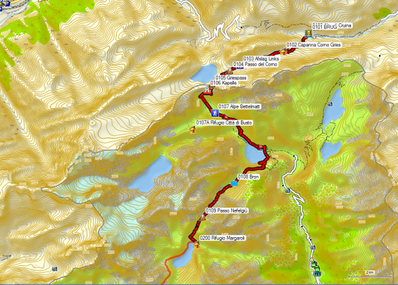
 The next morning I took the bus to the Nufenenpass after a hearty breakfast at 08.15 hrs. The bus leaves next to the railway station. It’s is a small yellow dial-a-bus type Post bus. It left with a slight delay and arrived at Alpe di Cruina around 09.00hrs.
If you want to take the first bus beyond the Nufenenpass in order to walk directly to the Griespass, you need to make a reservation by phone. To do so, view the timetable on the right-hand side of the station or consult the timetable via www.sbb.ch.
Alpe di Cruina turns out to be little more than a bus stop and a parking place for cars along the pass road. Walk into the parking lot and go through the tunnel under the road. The path to the Capanna Corno first goes down parallel with the road up to a small bridge (GPS 0101) and then turns right, as you start the climb to the Capanna Corno Gries. The path is very well marked. After 45′ you arrive at the hut Capanna Corno Gries Gries (GPS 0102). From the hut, continue in the same direction. You slowly ascend to a long narrow lake, which does not appear on the digital map of your Garmin GPS Recreational Map Europe V3 but does appear on the City Navigator Europe of the same brand.
 Here you will also find the first junction (GPS 0103), where you can turn right in the direction of the Nufenenpass. However, you keep following the shore of the narrow lake until its end. Here you will find the vague Passo del Corno (GPS 0104). Along the other side of the pass, you can already see the continuation of the path. Either take a vague path that leads you diagonally towards the path on the other side, or follow the fresh markings until you reach the signpost and turn left there until you reach the path that you saw in the flank. From this point, you have a beautiful view of the Griess lake, the glacier with the same name and the barrenness of the Bättelmatthorn.
 The above-mentioned path leads to the Griespass (GPS 0105), a pass that is not very pronounced or visible in the landscape, whom both the Swiss and the Italians gave their own location. Here you can cross the Swiss-Italian border and you notice this by the quality of the painted markings: perfect in Switzerland, acceptable in Italy. You need to turn on your GPS right away, to make sure you’re heading in the right direction.
The quality of the signposts also leaves to be desired in this respect, but I have noticed that this is quite often the case in other border regions as well :-(. A form of nationalism? Once you have determined the right direction, you go on without any problem up to the Alpe Bettelmatt (GPS 0107). This mountain pasture gave its name to a locally famous cheese, which is apparently sufficiently expensive to rob the cheese farmer from his cheese when he descends from his pasture!!
From the Alpine pasture, there are two possibilities: either follow the road on the left (dotted line in the Rother guide) or follow the path (full-line and GPS tracklog) which causes some problems because of the long grass, which makes it more difficult to walk on. When the weather’s bad, you choose the road.
The Lago di Morasco can also be rounded on both sides. If you took the road on the left bank, it is better to round the lake along the same bank. If you took the path, you can use the cut-off and descend via a vague track to the bridge over the supply river, to round the lake along the opposite shore. That side is a bit more adventurous, but you can even see parents with children’s buggies, who round the lake. A somewhat rickety signpost shows you the beginning of the path to the Passo di Nifelgiu. The path itself can be seen from the other side of the lake as a diagonal line in shrub wood. The abundant vegetation indicates a high level of soil humidity. A lot of work has been done to rebuild the path, but the water has still won the battle here and there. At an altitude of 2000m, you arrive at a better and wider road, which you follow to the right. From here on, the inclination is less steep uphill towards the Alpe Nifelgiu (GPS 0107).
Walk to the hut itself, cross the stream over there, and take the path on the left bank, which is marked. On the right bank, there is also a path, but that one is very unclear. Just before the pass, you end up in blockwork. After the pass, you will find a normal path again, but it is suffering from erosion. At the hut, pigs make sure that food waste is disposed of in an environmentally friendly way.
Rifugio Margaroli (CAI) (GPS 0200):
Walking time without rest: 6h45′ with rest: 7h15′
Tel: +39/0324/63155
+39/349/5795798
Open: mid-June to end of September
Half-board: 52€ (2024)
Dinner:
1°: Pasta or minestrone
2°: Polenta with cheese and stew with some vegetables in the sauce
3°: 2 cookies
Room: 3 beds, 3 high (only in the room), pillowcase and towel available, Bedliner sheet required.
Water drinkable despite the signs, which say that it’s not. Later I learned that it is mandatory to put up signs like that when the water does not fully meet the requirements of the government and these are getting stricter every year.
French toilets.
Day 02 Rifugio Margaroli – Alpe Devero
13.8km +481m -1037m 4u30′


 Leave the hut and round the lake counterclockwise. At the end of the lake, you stray a bit away from the lake, towards the Alpe Curzalma. Here you cross a stream and then you round the lake again, to start the final climb to the Colle Scatta Minoia (GPS 0201). Just before the pass, you’ll find blockwork again. The descent towards Alpe Forne Inferiore (GPS 0202) is easy. Just before the Alpe, you will find a small hut on the left side of the path. The main alpine hut itself is to the right of the path. You arrive at a very muddy gathering place of cows closed off by an electric fence. You’ll round this one clockwise, to continue towards the bridge over the stream. You cross the bridge to descend along the jeep road to the right (GPS 0203). There are signposts here, but they’re not mounted well. Actually, they lean more against the mountainside.
 The jeep road goes down steeply. When the jeep road fades at the beginning of the tree line, you will find fresh paint marks that lead you along a path to the left of the road and finally along the left side of a small hill. The markings can be found at large intervals, butthe path itself is clear.

Eventually, you arrive at a cottage along a larger road. Here you arrive at the ring road around the Lago di Devero. If the weather is fine, you’ll find lots of day-trippers here. Here, you turn left, i.e. straight on (GPS 0204). You won’t find a signpost here. You’ll find it five minutes further away along the path. If the weather is fine, you can descend to the shore of the lake (GPS 0205).
After the climb towards the passage of a steep rock plate, which is secured with a fence consisting of poles and steel wire (for the cows, not for the tourists J), you leave the wide road for a path on the left that remains better at the same level. At the dam, follow the path straight ahead, which ends up on a wider road. Follow this road downhill to Crampiolo (GPS 0206).
Updated description GTA 2019
Crampiolo is a very touristy place, where the Italians picnic a lot when the weather is nice.
Cross the bridge and a little further you turn right between 2 wooden fences. The path is indicated by the sign “Winterpad” (Winterpath WN06808). It is more pleasant than the gravel road to Alpe Devero, which most tourists follow. At the end of the path, just before the first houses, the markings are not completely clear, but instinctively you walk in the right direction. Where the path changes from a path to a gravel road, you’ll find a sign to the right indicating the “CAI-hut 3′ ”.
Rifugio Castiglioni (CAI) (WN06900):
Walking time without rest: 4h30′ with rest: 5h00′
Tel: +39/0324/619126
+39/333/3424904
Open: all year round
Prijzen 2024
H/P: 44€
1/2L rode wijn: 4,50€ (tamelijk zuur) (2019)
Douche (onbeperkt, sleutel aan bar): 2,50€
Dinner:
1°: Pasta or soup (beans & lentils)
2°: Pollenta and stew with some vegetables in the sauce
Room: 2 beds, 2 high (only), sheet bedliner required. French toilets.
Breakfast from 7 AM: White bread, cornflakes, muesli, 2 kinds of jam, coffee or tea.
Day 03 Alpe Devero – Alpe Veglia
14,4km +1100 -950
With rest: 7h45′, without rest: 7h00′

 From the CAI hut walk back to the signpost, where you left the path yesterday. Here you turn right in the direction of ‘centrum’ (center). You cross the bridge and turn right here. At the next bridge on the left, you’ll find the Antica Locanda Alpino (WN06901), an establishment that Rother recommends strongly, but in 2012 there was a sheet of plastic over the roof, which doesn’t make it look very attractive. In 2019 this was still the case. It is also more expensive than the CAI-hut. Here you cross the same river again via the bridge to turn left. You follow the road to a hamlet on the edge of the plain. Do not follow the road to the right of the houses, but pass in between the houses. There you will find a path that zigzags in the wooded and partially cleared flank of the mountain.
After 1 hour you reach the first alpine hut (WN06905). At GPS WN06906 you will find the exit to the Lago Nero and an alternative way back to Alpe Devero. 600m further on, you’ll find a signpost (WN06907) indicating the path to the Bivacco Combi e Lanza. At GPS WN06908, you have to cross the main river in several arms. Changing from low to high shoes is advisable here, especially for those who pass by, early in the season. You slowly climb out of the rhododendron zone, to reach the zone with only stones and old snow that is left behind.
From GPS WN06910 you reach a zone with insufficient paint markings, mainly because of the snow. In Austria, this problem is solved by painting very large signs that are visible over long distances. Obviously not here.:-(
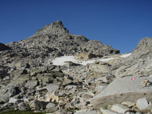
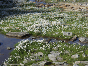
 You climb slowly until you reach the Scatta d’Orogna (2462m – WN06914). You make a curb through a bowl with a narrow lake and a supply river in the right flank At the supply river (WN06915), you have to watch out for residual snow. On the right bank of the lake, you’ll find a snowfield that reaches the water. Again, caution is required.
150m further you reach a kind of junction (WN06917), where a path was made downhill, that is stabilized with tree trunks and leads you to the bottom of the bowl. The path straight ahead is barred by a low stone wall. It remains the question of why this barrage was erected because at the bottom of the bowl you will find a lot of snow and again insufficient paint markings to be able to speak of a decent path. Moreover, the final climb to the pass goes through a steep snowfield and you better turn right of it back to the aforementioned path. From the Passo di Valtendra (WN06921) the path in the side of the mountain appears to be marked. In addition, the path remains better at the same level, going in a straight line to the Passo di Valtendra (WN06921). At the lowest point, you’ll find a horizontal chain, which hangs quite loose. In 2012 it was only used by me to secure a step of 50cm in a rocky part. The remaining part between the two passes was completed on walking poles.
After the Passo di Valtendra, there is a steep descent in a zigzag through a grassy bowl. Because the orientation here is simple, but finding the path itself is less so, several GPS points were marked.
 This is followed by a flat section up to a drinking trough (WN06931). After this trough, you will find a junction, where you go to the right. It’ll take a bit of time before you find your first paint markings. You descend further through the forest to a farm. Right in front of it, you cross a bridge. Walk past the farm to a second bridge, which you also cross, to turn left. Then descend on the right riverbank near the stream until you turn right at GPS WN06933. When you have a view on the houses of Alpe Veglia, you’ll find a sign to the left that indicates a narrow path in the direction of the CAI-hut Citta di Arona. The hut is beautifully situated in the flank of the mountain, just above the valley of Alpe Veglia.
Rifugio Citta di Arona (CAI) (WN07000): 

Walking time without rest: 5h30′ with rest: 6h00′
2019: 8:00′ (snow and detour between the two passes.)
Tel: +39/0322/48080
Open: early June to late September
Half-board: 40€ (2019) (Tarifs 2024 not yet online)
1/2L red wine: 7€ (fairly acid)
Shower (coin 3′): 3€
Total: 50€
Dinner:
1°: Pasta or minestrone
2°: One and a half sausages with large mixed lettuce
3°: cheesecake with chocolate sauce
Breakfast (7.00hrs): Bread, jam, biscuits, coffee or tea.
Room: 1 bed, 2 high (only in the room), sheet bedliner required.
French toilets, one ordinary toilet.
Day 04 Alpe Veglia – Gondo 16,2km +800 -1600
With rest: 7h45′, without rest: 7h00′

 From the hut, you descend along a path below the hut to the driveable road coming from the ‘center’ of Alpe Veglia. You cross the first bridge. Just before the second bridge ‘the official GTA’ leaves the road to the left. It climbs at first, to descends towards Varzo (500m). From Varzo the trail goes uphill again towards Rifugio San Bernardo, via an intermediate pass.
A shortcut via Gondo (800m) in Switzerland is proposed here. Cross the second bridge and turn left. A little further you pass a house where they try to sell minerals, but their dog is not really an invitation to do so. You descend into a gorge, to pass along a chapel. After this chapel, there is a concrete steep stretch of road, where you can’t even round the hairpin bends in one go with a pickup truck. The traffic on this road is reserved for residents and the hours at which you can drive up or down are regulated. Shortly after this concrete stretch, you’ll find the beginning (WN07005) of the Sentiero del Scinc.
The path is very narrow and rises sharply in the first part. The main problem is that the grass is very long and the rest of the vegetation is also lush, which makes it difficult to see where you can set your feet. You also move constantly on a very steep slope. This is followed by a fairly flat part and then a further ascent to a pass. Especially in the descent, you will find a number of chains, which are usually superfluous unless it is wet. Only when I stepped down from a rocky outcrop did I actually use the chain. Near GPS WN07007 a piece of chain was broken in 2019 and you had to go along the top of the original path. From the left, a vaguely unmarked (WN07008) path will appear, which can cause problems, especially for hikers walking in the opposite direction. Further on (WN07010) you’ll find a better path towards the Passo Del Croso (2395), which you follow to the left downhill. At WN07011 you arrive at the wide road coming from the valley, which you follow to the right uphill. With this variant via the Sentiero del Scinc, you win about an hour compared to the variant through the valley.
Until WN07015 (source) it’s best to keep on following the road and ignore all marked shortcuts, because most of the time they are of such a bad quality, that you won’t save any time using them. The source itself can be found in between the houses.
You return to what’s left of the road. At an intersection of two valleys, the Rother tracklog goes to the left. A little higher on a signpost (WN07017) with the inscription F32 Alpe Camoscella 0u30′ and Iselle 3u45′, turn right in the direction of this last signpost. Attention: the GTA is signposted here to the left, direction Passo Possette (2179). The Passo del Gialit is not indicated at all. After 10′ you reach an Alpe at the end of the previously used road, where there is a new Alpine farm. From here, you climb to the Passo del Gialit, via a rather weakly marked path, to descend from there to the Alpe Camoscella. Follow the direction Alpe Vallescia (WN07023. The path is easy to follow. It goes up and down a lot. In the flat sections, the path is only a trace in the grass. Around the Alpine hut of Alpe Vallescia, you have a lot of problems with cow manure. The alp is actively exploited. After the hut, you go uphill next to an electric fence to keep the cows out of the abyss. It continues on and off in the direction of Alpe Corwetsch (WN07027).
Here you will find the first signpost in the direction of Gondo (WN07100). You’ll soon be in the woods. A little deeper there are two more difficult passages through torrential rain gutters. Then you arrive at an abandoned alpine hut (WN07031), where you turn right at a right angle. From here you walk along a stone wall to the edge of the forest, where you’ll find signs. This is followed by a fairly flat part through the forest. You cross several bridges over flood-rain gutters. Further on, you get a view on a ruin of what once must have been a beautiful house with a terrace. You pass on the left side of the house (WN07032). Consecutively, you pass underneath the main building to the other side. Here you have to make your way through the stinging nettles and the sorrel and descend diagonally to the edge of the forest. From here on, you descend steeply through the forest. Watch out for the little pine cones, because they work like Rolling Stones under the soles of your shoes. The noise of the traffic in the valley rises up the slope, and slowly you descend between the bolder and avalanche protection walls to a signpost right next to the road. Here you go to the left through the forest to descend to the roof of an avalanche gallery. At the end of it, you arrive at the road near a petrol station with a small shop. Further on there is another petrol station with an even bigger shop. These are the only two supply points for the next few days.

Stockalperturm
As the Stockalperturm (WN07101) is relatively expensive, I moved to Restaurant/Albergo Bellevue (WN07100).
Albergo Bellevue (WN07100):
Tel: +41/(0)27/9791198
New manager: Sebastian Sqaratti Simplonstrasse 12, 3907 Gondo Wallis, Switzerland
Open: All year round
Room:
Half-board: 80CHF (2019)
2x 30cl beer: 7,00CHF
Tax: 1,40CHF
Total: 88,80CHF
Note: the first bus to Zwischbergen was full, so the owners took me to Zwischbergen by car. This is one of the advantages of a small business and owners with a feeling for their guests.
Dinner (18.30 – 19.00h):
1°: Largest lettuce in the Alps 🙂
2°: Local specialty; bread with ham and over it melted local cheese and scrambled eggs.
3°: Apricots sorbet
Breakfast: (from 07.00h if you ask and take the bus from 8.25h to Zwischbergen)
Large buffet: fruit juice, tea or coffee, bread, cheese, cold cuts, jam
Room: 1 bed with washbasin, toilet, and shower shared. Street noise during the day, reasonable at night. Warm in the hotel and of course in the valley. No air conditioning and with the street noise it is difficult to cool.
Bus to Zwischbergen : Every day at 08.25h and 10.00h possible if booked via +41/(0)79/7137002. Asking questions at the hotel is more practical. Price: 7,80CHF (2012).
Berggasthof Berg Zwischbergen
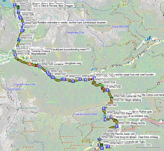
Day 05 Gondo – Rif Alpe Laghetto 14,1km +1200 -650
With rest: 7h00′, without rest: 6h15′
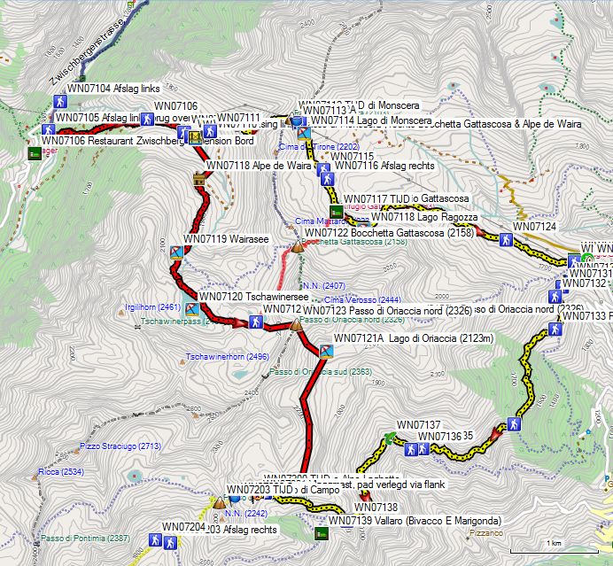

Green: via the Passo di Oriaccia Nord.
Red: via the Passo di Monscera and the Rifugio San Bernardo.
Under normal circumstances, the yellow dial-a-bus type Post bus arrives on time at 08.25h, is in front of the customs building (Zoll). The driver will drop you off at the bridge over the river (WN07105). As the on-call bus had a more commercially interesting ride in 2019, the hotel manager of Albergo Bellevue drove me up the valley to Zwischbergen.
You cross the pedestrian bridge (WN07105) over the river to climb the path up through the forest. You cross the asphalt road several times and later the gravel road to Alpe di Waira. In 2019 the path was very well marked, a textbook example of how to do it. Eventually, you reach a horizontal part of the road that you follow in a narrow part of the valley. You walk next to a mountain river. When the view opens up, you can see a few alpine huts. Just before the road makes a right turn to cross the river, you leave the road to the right. A bit higher you’ll find the junction between the paths to the Passo di Monscera and the Bocchetta Gattascosa (2158 – WN07122).
If you look closely at the map, you will see that Rother makes a rather nonsensical detour to reach the GTA at San Bernardo (WN07129). Once you’ve made the decision to walk via Gondo, Rother’s further suggestion to go via both the Bocchetta Gattascosa (2158 – WN07122) and via San Bernardo (WN07129) is nonsensical. But because I couldn’t find the correct information on the internet or in Gondo, I fell back on my knowledge from the past and walked over the Passo di Monscera (GPS0507) and San Bernardo (WN07129) to the Rifugio Alpe Laghetto. Only there I found the confirmation of the alternative possibility to walk from Zwischbergen more directly towards the Rifugio Alpe Laghetto.
The shortest connection between the Italian Rifugio Gattascosa (WN07117) and the also Italian Rifugio Alpe Laghetto passes partly over Swiss territory, which is always a bit difficult, especially for the Swiss. As a result, this possibility is left out on Swiss maps. But that this possibility exists has been confirmed to me by the tenant of the Rifugio Alpe Laghetto, and this via the Italian path D16. From the Rifugio Gattascosa (WN07117), you only have to climb around 150m to the Bocchetta Gattascosa (2158 – WN07122). From there you descend to 2 nameless lakes under the Passo di Oriaccia Norte (2326m – WN07123), after which you climb 100m to this pass. This path is more technical and less well marked, but still clearly distinguishable, according to the statement of the tenant of the Rifugio Alpe Laghetto). From the pass, you descend 200m to the Lago di Oriaccia (2123m – WN07121A) and then continue along the path D16 to the Rifugio Alpe Laghetto (WN07200).
If you want to use this shorter connection between Zwischbergen & the Rifugio Alpe Laghetto, at the fore-mentioned junction WN07108, follow the path to the right to the Bocchetta Gattascosa (2158m – WN07122) & the Alpe de Waira (WN07118). From the Alpe de Waira, you continue via the Wairasee (WN07119) & the Tschawinersee (WN07120) to the 2 lakes under the Passo di Oriaccia north (2326m – WN07123). And there you come to the above-described path between the Rifugio Gattascosa (WN07117), to continue via the path D16 to the Rifugio Alpe Laghetto (WN07200).
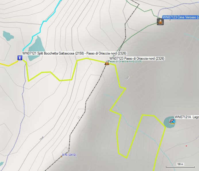
From the the larger of the two lakes at the junction between the Bocchetta Gattascosa and the Passo di Oriaccia Nord, you must count on the fact that you won’t find a classic path. Instead, you will find a debris field with large blocks up to just below the Passo di Oriaccia Nord itself. The horizontal distance along the proposed route is only 600m and the level difference is only 100 altimeters. Once on the Passo di Oriaccia Nord there is again more green to be seen instead of just gray of stones. Only at Lago di Oriaccia itself, are you relieved of the mixture of rubble and greenery. As the altitude chart already clearly shows, this path is significantly shorter and you also make fewer altimeters, but it is technically more difficult. In bad weather conditions it is better to follow the normal GTA.
But if you want to go via San Bernardo and the Rifugio Gattascosa, you better choose the route via the Passo di Monscera (WN07112). It is true that there is a pylon on the pass, but you have been walking under or near a high-voltage line from Zwischbergen on. If you only walk to the Rifugio Gattascosa, the extra hour of padding via the Bochetta di Gattascosa (GPS0506) won’t matter, but then you can as easily reach the Rifugio Alpe Laghetto (WN07200), as described above, via the Passo di Oriaccia Norte (2326m – WN07123).
If you want to go via San Bernardo to the Rifugio Alpe Laghetto, it’s better to choose the route via Passo di Monscera.
At the already mentioned junction (WN07108) between the road to the Passo di Monscera and the Bochetta di Gattascosa (WN07109), turn left on your way to the Passo di Monscera. You cross the bridge and then make your way through the long grass to a mountain pasture. Here you follow the left side of an Alp until you return to the road you just left. You cross a second mountain pasture towards the edge of the forest, where you will find a clear path again, renovated in 2012, up to the Passo di Monscera (WN07112).
At the Passo di Monscera, you cross the Swiss-Italian border again. The first thing you notice is the split of the path with a small cut-off (WN07113) in the right flank. The actual junction (WN07112A) between the path via the left and right banks of the river is situated down at the lake. To reach the Rifugio Gattascosa, turn right. Do not take the path that descends into the valley to the left of the lake, but take a fainter and initially unmarked track along the lake. This path descends towards a gravel road (GPS0508) which you follow to the right towards Rifugio Gattascosa (GPS0509) (2h).
This hut is a typical destination for day hikers. Anyone who enjoyed an extensive breakfast in Gondo and went up to Zwischbergen by bus, will not be really hungry yet, and can immediately continue in the direction of Rifugio San Bernardo.
You cross the terrace of the hut and then one of the two bridges over the brook near the hut. They both end up on the same path along which you descend towards Lago Ragozza (WN07118), a pleasant place for a picnic. From here the path becomes stonier and therefore less pleasant to walk. Here, too, you are confronted with the view of the high-voltage line, coming from the Passo di Monscera. Further down, the path passes through a swampy Alp, which is now bridged by a boardwalk, to continue back through the forest. The path leads to a wide forest road (WN07124), which you follow to the left until you reach the Rifugio San Bernardo (WN07125).
There is a large car park here, which immediately explains its popularity. Opposite the hut is a building with sanitary facilities. Follow the wide access road between the hut and the sanitary block until you reach the Chapel San Bernardo (WN07129) (1h5′). This is where the gravel turns into an asphalt road and that also appeals to cyclists. Here you return to the official GTA. When facing the chapel, take the forest road to the left. From here on, follow the signs to Campo (3u40′). This is the mountain pasture behind the Passo di Campo and therefore also past the Rifugio Alpe Laghetto. Here you alternately follow a forest road or path in the side of the slope. Ignore any path that leads to the valley. Shortly after the second signpost, a marked path leads to the left. However, the GTA goes right (= straight on) along a nearly unmarked path. At the third signpost, you go straight on. Early on you get a view on the dilapidated stone huts on the Alpe Orriacia (WN0737). You walk between these huts and then you climb to a large crucifix on a pass (WN0738).
 Here you will find a signpost with the indication Alpe Laghetto. At the bottom left is the Bivacco E Marigonda (WN0739), a well-equipped self-service cabin. Follow the path in the right flank of the bowl up to the Rifugio Alpe Laghetto. You won’t see the hut itself until the last moment. Just before the hut (2h15′), you’ll find a new signpost (WN0740) to the above mentioned Passo di Oriaccia Norte (2326m – WN07123). The markings were refreshed in 2019.
Rifugio Alpe Laghetto/ Rifugio Arsago Serpio (CAI) (WN07200):
Tel: +39/0347/0320298
prenotazionerifugio@caiarsago.it (Rifugio Arsago Serpio)
H/P: 51€ (2024 – incl douche onbeperkt)
1/2L rode wijn: 5€ (2024)
Dinner:
Zicht vanaf de hut richting dal na de regen 😦
1°: Minestrone
2°: Pasta and stew
3°: Cheese or cake (extra charge)
Room: typical dormitory divided into 3 rooms, with a total of 27 beds sometimes 2 high, sheet bedliner required.
French toilets.
Day 06 Rif Alpe Laghetto – Alpe Cheggio 9,8km +650 -1200
With rest: 5h45′, without rest: 5h30′

 You leave the hut to the right and follow the path that slowly climbs in the flank of the bowl. At an altitude of about 2100m, you will find a large cairn (WN07202), where the path, coming out of the valley, used to join the current path. You can easily climb to the Passo di Campo (WN07203) (even in the fog J). On the pass, you do not take the marked path to the right that passes between the rocks towards Laghi di Campo, but the descending path under the path to the Laghi di Campo, which first goes to the right, and then to the left. The path is fairly easy to follow, except at the end of it, just before Campo (WN07203). Here you will find a signpost, and from here on, the path is renovated and easy to follow up to the Alpe Preia (WN07208).
In Campo, you’ll find an underground picnic under a big boulder, but finding the right path in the fog is a lot harder. You have to go past the second bolder to the right, to find the first usable paint markings there. The new signposts are still poorly positioned to be really useful. If you look to the right just past the rock with the picnic, you’ll see a small hill on the left at the edge of the path. To the right of this hill, you can see a small pass. This route leads you in between the old snowfields. From this pass, the path is much clearer.
 Up to the Passo della Preia (WN07211), you won’t experience any further difficulties. On the pass, the GTA does not take the route to the left along the ridge, but the well-marked descending route towards Alpe della Preia (WN07212). You extend your sticks by 20cm for this descent. On the Alpe della Preia, the path to the right is closed. Therefore only the path that descends sharply to the left towards the ruins of some alpine huts (WN07213) remains usable. This path is quite narrow and very overgrown. At the Alpe Teste Inferiore (WN07215), don’t take the path to the right to the Alpe Gabbio, but follow the direction CSI in the opposite direction and go diagonally through the herbs to the left in the direction of another pole (WN07216), where you again follow another CSI signpost in the opposite direction. Furthermore, the path is marked white/red. The path is again very narrow and strongly overgrown. Moreover, you often find yourself on a steep slope. You’ll find a lot of raspberry bushes here, but you have to be very careful when picking them because of the state of the path. Especially when it has rained, the path is very slippery.
 At your feet lies Lago Alpe del Cavalli (WN07220). On the way, the path that led to the Bocchetta dei Pianei (2310) on the Passo della Preia on the left along the ridge, returns to the GTA (WN07217). This variant, which is more alpine, is also half an hour longer.
You stay at the same height for a long time and only descend when you are already above the lake’s dam wall. At the signpost at the road (WN07218), which comes from the dam wall, turn left towards the church. Just past the church, you will find the Albergo Alpino (WN07219). Here you descend between the houses in the direction of the Rifugio Citta di Novarra (WN07300).
Rifugio Citta di Novarra (CAI) (WN07300):
Tel: +39/0324/575977
Open: 20 June to 1 October
Half-board: 38€
1/2L red wine: 5€
Shower (unlimited): 0€
Dinner:
1°: Minestrone or pasta
2°: Roast beef with potatoes
3°: Dessert
Lunch: (busy during the day with day-trippers)
1°: pasta with bread 6€
2°: 1/4L of wine (on the house because I had to wait a long time because of the afternoon lunch rush)
Total: 49€
Room: 5 beds 2 high (only), sheet bed-liner required.
French toilets.
Day 07 Rif Alpe Cheggio- Alb Loc. del Tiglio 19.6km +1050 -1900
With rest: 8h15′, without rest: 7h15′
 You walk out the front door of the hut and follow the road downhill. After the last house, you will find the beginning of the path downhill (WN07302). The path is bordered locally with long grass, weeds and covered with stones which are slippery when wet. At a certain moment, you return to the road (WN07306), to leave it further on (WN07307). You end up in a meadow, which you cross along the right fence of the meadow (WN07308). In the proximity of the road, you cross the fence without a gate. You cross the road to follow a path in the forest for a long time. You reach the road (WN07311) again and follow it downhill. At GPS WN07314 you leave it again. Finally, you arrive at the outskirts of Antronapaina. You walk towards the church. On the left, you will find a shop (GPS0701). The ATM (GPS0702) on the square below the village, was removed, and that is a serious problem. In practice, this means that you have to bring cash for even more days. At the beginning of the road from the village towards Domodossola, you will also find the bus stop (GPS0703).
However, this bus only drives to Domodossola at around 17.00 hrs, which makes it unusable in practice. As a result, you have to walk a distance of 6km mainly along the road :-(.
Follow the road down for about 100m and then cross the Torrente Ovesca via a bridge (WN07318A). At a fork in the road (WN07318B) turn left towards the cemetery (WN07318C). There the asphalt turns into a forest road. You still climb a little and then definitively start the descent. You reach a private road (WN07318D), which you follow downhill. In Locasca (WN07320) it is better to just return to the main road (WN07319) because what the GTA is doing here is just follow hard to find pieces of gravel road next to the asphalt road.
Follow the road to Prato (WN07330), and then onwards to the first bus stop past Prato. From this stop (WN07331) you walk another 300m in the direction of the valley and Domodossola. You first pass a soccer field on the left and when your arrival is detected by several dogs on the right side of the street, you know that you have reached your turn-off. You have to turn right just past the house of the dog fan to find the path (WN07332) to the Rifugio Alpe della Colma. The path to the hut is very well marked and very well maintained. The first part of the climb is very brutal. You pass several alpine pastures with buildings in varying states of maintenance, before arriving at the Rifugio (WN07339).
Rifugio Alpe della Colma (WN07339): 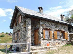

Tel: +39/339/7511653 12 beds
Pasta only served at lunchtime (7€).
The tagliatelle is made in front of your eyes in the hut, which of course is a lengthy process. Opponents of fresh pasta will say you can’t cook it “Al Dente”. I myself would never consider making it fresh. But I’m also not a real fan of Italian cuisine because of the quantity of carbohydrates used.
When you enter the cabin you will be asked by the owners to switch off your mobile phone and GPS, because they claim to be sensitive to radiation. Maybe they should read a little better about what’s on their tobacco boxes. Smoking is proven to take 8 to 10 years of your life. Radiation is only statistically proven to be dangerous for young children (childhood leukemia). And above all: a GPS doesn’t transmit anything. It’s just receiving… A cell phone, of course, is transmitting.
The owners of the rifugio don’t want to encourage you to go further L, because further indications are rather unclear and scarce. To find the way to the Colma dei Prei (GPS0707), you have to walk over the terrace of the hut. On the other side of the terrace (at the kitchen door of the hut) you’ll find on the left a fairly good path, which is now marked with the usual white/red. Make sure you don’t take the horizontal path straight ahead because it’s a dead end.
After a flat part, which is easy to follow (even in fog :-)), you’ll finally find a signpost (WN07341) on a building to tell you that you’re walking in the right direction. From here on, you can start the descent. Initially, this is via a beautiful path in the forest. But at the first alpine hut (WN073413), however, you’ll have to watch out very carefully. Those who looked closely at the map in the Rother-guide were already warned J. If you see two variants, it usually doesn’t bode well. Just in front of the hut, you will find only wooden signposts, but not the usual white/red signs. The path now runs parallel to the edge of the forest. When you reach an Alp, cross it diagonally across towards the end support of a material lift, and then further down to another hut. You’ll pass this one on the right. A little lower you see a path that goes diagonally to the left through the meadow. You follow this down and end up on a wider road, which you follow to the left until you arrive at a hut near a material lift again. Here you will find another signpost. A bit lower, near another building, which looks more like a holiday home, you’ll find another arrow to the left (GPS0712). Here you can follow a horizontal traverse to another group of buildings in natural stone. Here you descend diagonally to the right, where you’ll find another good path to a hut with a chapel (GPS0713).
 You descend through the forest to the first parking lot. You go to the right and just past a house that was heavily renovated in 2012, you will find a path down that passes through the beautiful hamlet of Olino and ends at a lower parking lot. Directly opposite the end of the path, you see the endpoint of a material cable car (large rubber tire). To the right of this support, you will find a signpost and the beginning of a path. The path itself is good. You walk to a signpost, with only indications to the left (Bus stop Molino). You turn right here until you reach the hamlet of Vigino. Here, before the river on your left (WN07359), you take the stairs down. You follow a route between the houses until you reach the end of the hamlet with two houses (WN07360) next to the canalized mountain stream. Here you cross the bridge to the right, back to the road. Follow the road down a bit until you see some markings on your left. This path crosses the bends of the road. The Rother tracklog doesn’t do this. Keep descending to the main road in the valley (WN07362). Here you turn left to the Albergo Locanda del Tiglio (WN07400).
Albergo Locanda del Tiglio (WN07400):
Tel: +39/0324/81122
Note: given the limited capacity, be sure to book from the Rifugio Citta di Novarra.
Note: strategic overnight point, unless you want to sleep in a self-service cabin.
Open: all year round
http://www.albergolocandadeltiglio.it (Website not functional 😦 ). Use: https://www.rifugidellossola.it/locanda-del-tiglio/ instead…
Half-board: 45€ (2019)
1/2L Red wine: 4€
Dinner:
1°: Both gnocchi in a cheese sauce and pasta pomodoro
2°: Milanese with lettuce
3°: 3 Pieces of pizza
4°: Dessert
Breakfast:
1 croissant (packed), 1 roll (30cm), 3x jam, butter, coffee or tea. (typically Italian) Room: 1 with one fixed bed. Private shower and toilet.
Day 08 Alb Loc. del Tiglio – Campello Monti 15.9km +1950 -1100
With rest: 8h30′, without rest: 8h00′ (First 4 hours in the rain)
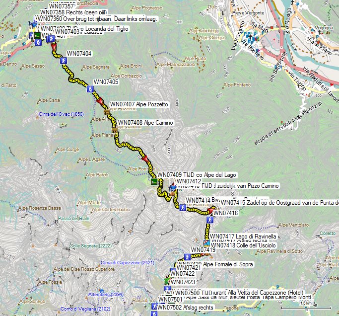

 From the Albergo Locanda del Tiglio (WN07400), you return to the point where you entered the valley yesterday on the main road (WN07362). Here you go to the left down the stairs and walk to the bridge over the river at the church. The church is really beautifully situated. On the other side of the road turn left, to find a mule track up to an asphalt road (WN07401). Follow this road to the left until the end of the asphalt (WN07402). Here you cross the bridge (WN07403) and follow the gravel road along the river. The road is gradually getting worse. Just before the end of it (WN07405), take a path up to the left. After the last bridge over a tributary, you come at a fork in the path, where you turn left. The path climbs very steeply zigzag through the forest. You pass several Alpine huts. The path then passes through a semi-open spot in the forest, which as usual, next to being marshy, can be strongly overgrown with herb, so you have to pay close attention to the path. After this clearing, you will enter the forest again until you definitively leave it at the tree line. Here you continue for some time until you reach the Alpe Camino (WN07408), which was operated in 2019 by someone who looked after goats, so the usual jungle of herbs was missing. Later on, you will have to deal with very long grass again, which in some places is also very annoying. Watch out for ticks! Further on, the path has been widened, so that the inconvenience of the long grass is less. You climb to the highest point (approx. 1600m) and then descend to the self-service cabin Rifugio Alpe del Lago (GPS0801) (3h30′).
Rifugio Alpe del Lago: 9 beds with blankets, always open, stove on gas, wood fire, (messy), hose with running water. No visible herding activity in 2019. The cabin Bivacco Alpe Pian Lago is located at 1h30′ and is clearly neater and better equipped, except for the blankets.
From the Rifugio Alpe del Lago you have to return on your steps and cross the bridge again. Then you follow an initially very vague, but marked path left of the river, up to a gorge where the river comes out. Here you climb up the slope to the left of this gorge. At the top, you come in a kind of bowl, with lots of rhododendron bushes in combination with long grass, so you have to be very careful to follow the path. The course of the path is very erratic, and for a long time you will be kept in suspense, to which pass the path will eventually lead. It’s not a pass in the direction from which the river is coming, because they are way too high, but the left one of two lower passes to your left. From the pass on the ridge south of the Pizzo Camino (WN07410) (45′) the path descends along the other side of the ridge, first going 250m to the left, then going underneath to the right and then climbing again for a short while to finally descend to the Bivacco Alpe Pian Lago (WN07413).
Bivacco Alpe Pian Lago (WN07413):
Much nicer self-service cabin than the last one. This one is owned by the municipality. Cleaner, better equipped, gas cooker and useful cooking utensils, nice terrace, no blankets, 6 beds. No exploitation in the area in 2019, so the grass is also very long here. So pay attention.
From the hut, you walk 750m almost flat in the flank and then make a right turn and ascend to the small pass (WN07415) on the east side of the Punta dell’Usciolo. The pass is already visible from the hut.
On the left, you have a viewpoint here. On the other side of this ridge, walk to the right and stay at approximately the same level until you reach the bowl (WN07416). You’re climbing to a fake pass. Then you descend lightly to the Lago di Ravinella, which you round along the left. Just above the lake, you will find on your left the exit to the valley (WN07417 – San Guido & Forno). Here you have to go straight on to the real Colle dell’Usciolo (WN07418).
From the col, you descend again over a ridge between 2 mountain streams. 200m below the pass you will find a signpost (WN07419) near stables. Just before the confluence of these streams, you will find the stables of the Alpe Fomale di Sopra (WN07420). Here too, there was no form of exploitation in 2019, which again resulted in very long grass. After the stables, you cross the brook on your left (WN07421). Then you descend via the left bank, and after the confluence of all streams, you cross the river (WN07422) to the right bank. Then the path goes up lightly, through a stretch of forest, after which you get a view on Capello Monti. For once the path doesn’t descend straight to the village, but first turn right diagonally to end up on the path (WN07424) coming from the Bocchetta di Campello/Rimella. 
If you want to spend the night in the Posto Tappa (WN07426) you have to turn right here 200m, slightly uphill to the Alpe Sass da Mur (WN07425), where you can obtain the key to the Posto Tappa. A deposit is asked for the key (15 € / p).
Posto Tappa Capello Monti (WN07426): Second floor of an old school building with shop and meeting room on the ground floor. Salmon pink building with green shutters on the playground. 7 bunk beds 2 high, shower with hot water, washbasin, normal WC, chairs (15€/p (2012))
Restaurant/Pizzeria/Albergo Alla Vetta del Capezzone (WN07500 just across the bridge):
Half-board 42€ (2019) (room with two beds and shared sanitary facilities) Very limited capacity. If full, there is still the Posto Tappa, but then you have to walk back up to the alpine pasture to fetch the key of the Posto Tappa (if there is no one else present yet in the Posto Tappa, which is unlikely given the increased traffic on the GTA). For food, you have to rely on the restaurant anyway.
1/2L Red wine: 3,50€
Breakfast: (from 6h30)
Very copious: ample amount of bread and not dried out, 2 slices of ham, 100 gr cheese, jam, 2 teas /coffee
These people have clearly understood that the predominantly German and Swiss mountain hikers have different breakfast habits than the Italians. 🙂
Day 09 Campello Monti – Alpe Baranca
18,8km +1600 -1300
With rest: 8h30′, without rest: 8h00′

 After breakfast in the Albergo, walk (back) up to the Alpe Sass da Mur (WN07425). If you slept in the Posto Tappa yesterday, you will get your ID-card back after paying 15€ (2012). From here on, you really tackle the climb to the Bocchetta di Campello/Rimella (WN07505) (in the Rother guide: Bocchetta di Campello, on the signs in Campello Monti: Bocchetta di Rimella). You cross the brook to find a signpost (WN07501). You climb further south, to a stretch of forest. Back on the mountain pasture, near GPS WN07502 you will find a signpost near an Alpine farm, where goats were reared in 2019. You walk uphill, next to the electric fence, without crossing the brook.
 At an altitude of almost 1700m, you will find a signpost near the Alpe Scarpia (WN07503). 75m further you cross a tributary (WN07504). The further climb to the Bocchetta di Campello/Rimella (WN07505) is problem-free and well marked. Just behind the pass (WN07505), you’ll find a seating area (WN07506).
Before starting the descent, it is advisable to turn on the GPS. In 2019, the underlying mountain pasture was exploited by a shepherd with a herd of goats and sheep. As a result, the path was more clearly visible and marked in 2019. You’re leaving the pass in a southerly direction. 150m further you leave the path that descends to the Alpe di Pianello. In 2019 there was no indication of a possible Rifugio Borgomanero (CAI) on the terrain.
But in 2019 you were sent to the right near GPS WN07507. You descend to an altitude of 1800m. In the flatter part there, you will be sent to the left again in the direction of the Alpe di Pianello. But after 100m you leave this direction again to go through the bowl in a westerly direction until you arrive at a signpost (WN07508) on a wider road coming from the Alpe di Pianello. From here on, you follow the mule track down to the asphalt. Fortunately, the border stones are usually large and flat, so you can walk on them instead of the typical boulders that normally form the “road surface”J.
In Alpe Selle (WN07509), above the village, turn right towards a riverbed. You enter the forest, and 500m further you reach a fork in the path (WN07511), where there are no meaningful signposts.
Here there are 2 possibilities:
- T
 urn right and follow a path that remains largely at the same level until you reach the church of Villa Superiore (WN07512). A bit further you find a path (WN07513) down between the houses up to a parking lot (WN07514). At the beginning of the road, you’ll find a path (WN07515) to the left that crosses the hairpin bend in the road. You cross the road (WN07516) and continue your way down the path. At the edge of Prati (WN07517), go straight down. You will reach Rimella and continue straight down along the church and the town hall (Rother).
 - If you turn left, you will soon reach the asphalt. But after 500m you leave this again via a path to the left, indicated by local signs GTA. It leads you to
 Sella, after which you cross the hairpin bends of the road, to finally end up at the church of Rimella. Turn left of the church in the direction of the town hall. Here you descend left in front of the building to pass the Albergo Fontana (WN07518). (2012)


Then go down to the left until you reach the asphalt. Along the way you pass a source (WN07519), where you can also sit in the shade. On the tarmac, you turn right to the first hairpin bend, where you’ll find a path at the end of 2 material cable cars (WN07520), just past a side road to Pianello. The path descends to the bridge over the Torrente Landwasser, then starts the climb towards La Res (WN07526). In the villages of Roncaccio Inferiore and Superiore, you have to be careful, because the difference between the path and the private access to a house is often not very big. In Superiore, you pass by a Rifugio (GPS0908), which is supplied by a cable car. From here you follow a nice relatively flat path through the forest. Just before La Res, you walk through an alpine pasture, where the path fades a little. You climb to the pass, where you go to the left and immediately to the right, near an information panel (WN07526) of the Via Alpina. Here you follow in a northeasterly direction. The beginning of the path that descends from La Res (WN07526) is also vague, as it passes through an alpine meadow. Once at the tree line (WN07528) you will find a very clear path to Belvedere (WN07530). Just before the hamlet, you turn sharply right (WN07530). Along the way you pass a water collection point with a tube where you can tap water (WN07531). 200m further you left this path in the past (WN07532 Trajectory change) to the left. Now you leave this just before Ronco sharp left (WN07523). You return to a church that you just saw from above (WN07524). You reach Bocco Superiore (WN07525) and descend through the village to a better road, where you return to the old track.
The path becomes fainter and has problems with overgrowing grass. Above La Piana, there is another change of route (WN07527). You don’t descend in between the houses but continue straight on via a little-used path with nettles towards a few detached houses, where you will descend to the asphalt (WN07528).
From here on, you can’t avoid it until the end in Campo (WN07530). On the way, you pass by the hamlet Santa Maria (WN07529), with a Posto Tappa that is closed at this time. The B&B Yellow House is now open. In Campo (WN07530) you will find signposts and a path to the Alpe Baranca (1h).
You ignore the first exit to the left in the direction of a metal bridge but continue to climb along the same bank up to a tube bridge (WN07532), where you can bathe when the weather is fine. Here you cross the river and continue to climb slowly until you reach the Alpe Baranca
(WN07600). The hut itself is a little to the right of the path to the Colle Baranca. The mast with an Italian flag, which you can see flying along the path, just past Alpe Baranca, is a chapel.
Alpe Baranca (WN07600): 
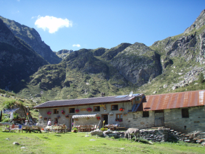
Tel: +39/347/8659385 Open: mid-June to the end of September
rifugioalpebaranca@gmail.com
Half-board: 45€ (2019 – no recent tarifs online)
1/2L Red wine: 5€
Small beer: 3€
Dinner:
1°: Anti-pasta (very wide choice, almost a meal in itself) Photo 2012 (before the fire) 2°: Pasta Pomodoro
3°: Sausage with beans (canned)
4°: Cheese (if there is still an empty spot left in your belly)
Already during the meal vomiting tendencies were experienced. Problems with food hygiene?
Breakfast: Toast, jam, muesli, coffee or tea, no cheese or meat. (Take-away, due to lack of appetite)
Room:
1 Dormitory under the roof.
One shower and toilet. (Pretty crowded by 1 family with children and some more couples, well full… ).
Day 10 Alpe Baranca – Carcoforo 8,3km +700 -900
With rest: 4h00′, without rest: 4h00′
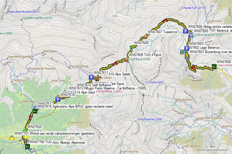

 From the hut, you walk to the right up to the main path to the Colle Baranca (GPS1003). First, you pass the flagpole at the chapel, where the path makes a zigzag to the left. Then you climb up along the river to the tube bridge (WN07601) just below Lago Baranca (WN07602). It then turns right from the lake to the Colle Baranca (WN07604) (45′).
On the pass, you will find a drinking trough (WN07605). Here you go left between the houses. You will find an old inn with an inscription on the facade, wherein 2019 there were traces of active exploitation, but probably not at the early hour that I passed there. You pass a drinking trough for cattle, and you follow the road until you see a signpost (WN07606), where you leave the wide road to the (dilapidated) Villa Lancia to the right for a path, which climbs. The path is sometimes somewhat blurred in the flat grassy areas, but it is well marked. Via a pass (WN07607) you climb to the Colle d’Egua (WN07609 -1h40′). From here, in clear weather and if you are early enough, you have a beautiful view of the Monte Rosa group.
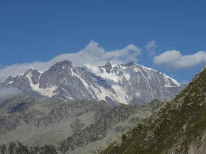 From Colle d’Egua take the marked path. At the Alpe Seletti (WN07610), pass to the right of the buildings, and turn right at the last building. 150m further, after crossing a streambed, you’ll find a signpost (WN07611). Here you take the descent path to the left, not the horizontal path to the right. 200m further south, 50m before the Alpe Egua, the path returns in northwestern and later western direction. You descend further until you arrive at a junction to the Rifugio Boffalora/Paolo Majerna (WN07613 – CAI). The path to the hut is the clearest at the moment, and if you want to have a drink or a meal in the hut, feel free to follow the markings straight ahead. The variant to the left is not shorter, and certainly more overgrown, than the one via the hut. Both variants come back together on the Alpe Giant (WN07614), just below the Rifugio.
Beneath the hut, the markings lead you in the direction of a streambed (WN07616), where you should wade. On your right, you’ll see a bridge (WN07615), which you can use to cross the brook. From the valley, it is better signposted. At an altitude of about 1500m, you pass the Agriturismo Bruc (WN07618). 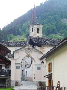
At the beginning of the village, you pass a GSM mast (WN07620). Then you go through the village, past 2 churches to the asphalt. Here you turn left over the bridge, after which you’ll find Albergo Alpenrose (WN07700) (2h) on your right-hand side.
Albergo Alpenrose (WN07700):
Tel: +39/0163/95646 or /95601
Open: early June to late September
Half-board in a common room: 45€ (2019)
Half-board in an individual room: 55€ (2019)
1/2L Red wine: 4€
Pasta ragou in the afternoon: 8€
Dinner (19.30h):
1°: Tagliatelli with wild mushrooms
2°: Pork strips, pork leg or roast.
3°: Cake
Breakfast: very large breakfast buffet Several types of bread, toast, cheese jam, ham, muesli, coffee or tea, fruit juice, yogurt.
Room: 2 common rooms with bunk beds. Each with shower and toilet. (with 3 in one room)
An individual room is possible at an extra charge.
Shop: 1 (WN07621) Opening hours unpredictable.
Day 11 Carcoforo – Rima 8,7km +1050 -900
With rest: 4h30′, without rest: 4h00′

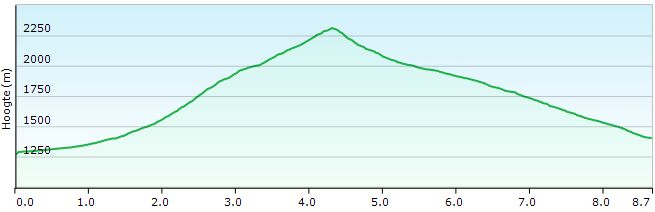 As I had walked for 7 years to the Rifugio Ferioli because of weather forecasts for the next night and morning and I liked it, this was also my initial plan. According to the information in the Rother guide, the Rifugio Ferioli only opens in early August. However, this turned out not to be correct according to the information published in Rima. If you want to be sure of the accessibility of the Rifugio Ferioli, you should check out the site of the CAI’s local department: www.caiolgiate.it.
From Albergo Alpenrose (WN07700) you turn left, back over the bridge. Then go straight on and pass a group of houses on the left side. You keep following the road until the end of the rideable part. First, you turn left (GPS 1102), at a first bridge. Then you go on until after the second bridge, where the road is no longer passable. Here you cross a second bridge. A little further you will find a signpost (WN07702). Here you go left up. Higher up you’ll find an arrow with GTA between the houses of the Alpe Selva Bruna (WN07703).
In 2019 this Alpine farm was operated (cows). You cross two brook beds and then it zigzags up a good path along the Torrente Trasinera to the Alpe Trasinera Bella (WN07705). This mountain pasture is exploited by a shepherd, and that can be seen along the path. You go up in the direction of the dilapidated Alpe del Termo (WN07706). The path continues without any problems, except in the bowl under the Colle del Termo (WN07707). In the gravel field there, you have to be careful to distinguish the path. The markings are not very good here, and from above the path is more visible. From the Colle Terme (GPS 1104) you again have a partial view on the Monte Rosa.
In the descent follow the path first goes 100m to the left, then descends in a zigzag to 2050m. The path is reinforced with wooden beams against erosion by water and sheep. The upper part is grazed. Then there is a traverse of about 500m to the right, after which the descent through the forest begins. The descent is long, but not so difficult for the knees.
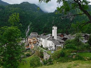 At an alpine hut (WN07710) you will find barking dogs on a leash. You descend further through the alpine meadow and then through the forest until you join a second path. You won’t find any indication here. You descend further down to the village to continue straight ahead through the village.
On the main square, at the entrance of the church you will find the Albergue Alpino (WN07712), today the information point for the Posta Tappa (WN07800).
Posto Tappa (WN07800): 
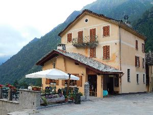
14 beds, 1 shower, 2 toilets, electric towel dryer, pellet stove, covered terrace with a magnificent view.
Beds with duvet and set of disposable sheets and indeed a pair of disposable hotel bath slippers.
In the bathroom also hotel shower soaps.
Albergue Alpino (WN07712): 
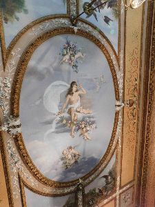
Half-board 50€ incl. overnight stay at the Posto Tappa
Dinner (19.30h):
1°: Pasta or broth with pasta
2°: Brasato or Vitello Tonnato with cold potato lettuce
3°: Cake
Bottles of wine: from 16€
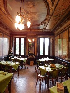 The facade along the car-park or valley side of the Albergue Alpino betrays that it is a Walser house, but the interior of the restaurant leaves you speechless. It’s a kind of showcase of the skills of the craftsmen in Rima, regarding fake marble. Really amazing. You eat under the watchful eye of a lady with bare breasts painted on the ceiling. Except for the heating system, everything seems pretty original. Beautiful!
Breakfast luxury (7.00h): Several types of bread, toast, cheese jam, ham, cereals, coffee or tea (even white), fruit juice, yogurt.
Day 12 Rima – St’Anton di Val Vogna 15.1km +1400 -1100
With rest: 6h00′, without rest: 5h45′ (cool climb)

 You turn into the street at the sidewall of the church, which you also use to walk to the posto tappa. On the square with the pump, you go left straight on instead of right straight on to the posto tappa. Behind the first house, turn left and at the first possibility turn right. You now walk next to a stream and find a signpost at GPS WN07801. Walk behind the houses and then turn left over a small bridge. The path goes up between cottages to a fork in the road at a large info panel (WN07802). Here you turn left in the direction of Rifugio Ferioli. It’s a good path. Higher up you’ll find another junction, with a large signpost on the left (WN07803). On the right, you’ll find a small arrow leading you up to the Rifugio Ferioli.150m higher you are on the Valmontasca (WN07804). Another 150m higher you are on the next alpine pasture (WN07805 Alpe Vorco). Further on it goes up to the Colle Mud (WN07806) without any problems.
From the pass, you descend via path number 8. Further down there is a junction (WN07808), where you go to the right if you want to visit the Rifugio Ferioli (WN07809).
In 2012 it started to rain lightly, on arrival at the Colle Mud. An hour later this turned into a full-fledged hailstorm. After the hailstorm two more day hikers descended to Alagna, making me the only guest that evening.
Rifugio Ferioli (CAI) (WN07809): 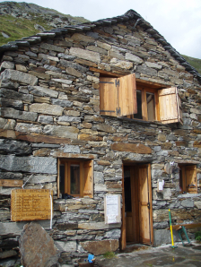

Walking time without rest: 6h30′ with rest: ca 6h40′ (From Carcaforo)
Tel: +39/0163/91207
Tel: +39/334/5631105
Open: 5 July to 15 September, weekends only until 29 September (dates 2019, see website for current dates!!!).
Prices 2012:
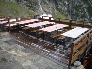
Terras na de hagelbui 😦 .
Half-board: 29€
1/4L Red wine: 2€
Total: 31€ (Everything else on the house)
Note: since I was the only guest, I ate together with the crew of 4 men in the kitchen.
Dinner:
Happy hour 🙂 : 2 carafes of wine with cheese and salami, smoked ham, fat
1°: Anti-paste
2°: Pasta ragù
3°: Polenta ragù
4°: Cake
5°: Coffee with schnapps.
Breakfast: Toast, jam, coffee or tea, no cheese or meat.
Room: complete dormitory for me only
Note: the supply of bread and cake is done on foot. Everything else is delivered by helicopter. The hut is a fairly simple and small hut. When the weather is good, you can eat on the spacious terrace, and when the weather is bad, you can eat above the kitchen. There is a freight elevator from the kitchen and a stepladder for operation. You can sleep in the cabin next to it. In another cabin, you will find one shower and 2 French toilets.
However, if you have slept in Rima and do not want to take a break, you can turn left at the junction above the hut (WN07808). The path is shorter, but little used, and early in the season you will have to swerve because of snow debris. In practice, you’ll get down quicker, passing the hut, as the path is significantly better.
Both paths converge at GPS WN07810. 100m down you reach the Alpe Venghy (WN07811). Another 150m down you pass the Alpi di Mud di Mezzo (WN07812). In the higher part of the descent, you will find a lot of loose material on the path. The lower part is grazed by cows.
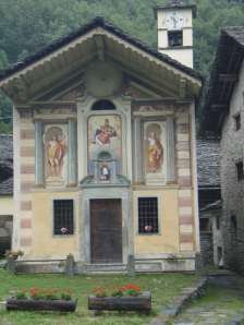 In the wooded area, there are deviations, both from the Rother tracklog and the path indicated on the digital map. You come to a stretch of a path where people have made stairs by nicely stacking stones. You can cross the river at a flood dam, but the signs lead you to a lower bridge (WN07814). A little further you arrive at the asphalt. You walk over the asphalt through Pedemonte and pass a church with beautiful frescoes on the facade.
At the bridge, you can take the gravel road before the bridge and follow the asphalt over the bridge to the left. 200m further you can’t avoid the asphalt anymore and follow this to Alagna (WN07818). Here you will find two ATMs (WN07817 & WN07820), a small grocery store (WN07819) and many expensive hotels. It’s not a place that makes me happy.
At a fork without a signpost (WN07821), turn left. 50m further you will find a covered picnic with a spring (WN07822). 150m further you reach the main road, which you follow 50m to the right to cross the river via a pedestrian bridge. 1,5 km further you reach a concrete bridge (WN07826), where you cross the river again.
You cross the SP299 and follow a street next to an apartment building, which is a dead-end for car traffic. You follow this until you reach the Via Real. If you want to see the special church of Riva Valdobbia (WN07828) (photo page 83 Rother), turn left into Via Real. If not, follow the rising asphalt road in front of you. In the first hairpin bend, the two come together again.
A little less than 100m past the bend, you will find a small wooden signpost with the indication “Alta Via”. Take this vague path to the edge of the forest, where the road widens. At a GSM mast (WN07830), follow the road to the left. In the next hairpin bend, you leave the asphalt again via a small path next to a drinking water collector in a small building. Just before a picnic at a war memorial, you return to the asphalt, not to leave it until the Rifugio Sant’Antonio di Val Vogna (WN07900).
Rifugio di Sant’Antonio di Val Vogna (WN07900): 

Tel: +39/0163/91918
+39/347/3368950
Open: all year round.
Half-board in Dormitory: 38€ (2019), very limited capacity in terms of rooms (I only saw one double room).
1/4L Red wine: 3€
4dl Beer: 5€
Deca: 1,20€
Lunch (2012):
1°: Homemade ravioli with bread: 4
2°: Rabbit with potatoes: 12€
Dinner 2019 (20h):
1°: Homemade ravioli or pasta pomodoro
2°: Rabbit, goulash or brassato with potatoes
3°: Cheese or pie.
Less crowded in the restaurant than 7 years ago, as the last part of the road is closed to normal traffic. What impact does such a measure have on the quality of life of the restaurant/posto tappa? And it wasn’t that this place used to be black with the people or that there was heavy game parking being done.
Breakfast (7h): Bread, toast, jam, chocolate, coffee or tea.
Dormitory under the roof: minimal separation by partitions, some bunk beds, and ordinary beds. Shower and toilet.
Day 13 St’Anton di Val Vogna – Rifugio Rivetti
With rest: 6h00′, without rest: 5h30′


 Leave the Albergo to the left and follow the gravel road in line with the asphalt until you leave the road just before a small hydropower plant via a path (WN07901) that goes up to the right. The road effectively stops at the hydroelectric power station. Then follow the broad path along with the church of Peccia, until you reach the Napoleonic bridge. Immediately after this bridge over a tributary you’ll find a signpost and turn left via a wooden bridge over the main river.
You follow this path further upstream and pass the Alpe Buzzetto (WN07904), where an organic farmer breeds West-Highland cows and sells organic products. At waypoint WN07908 you cross the main river. It is very difficult to get ahead here, because of the landscape itself on the one hand and the presence of cows and their tannins on the other hand. The path is marked by often small cairns and a few recently refreshed paint signs, which are also applied at large intervals. Attention is therefore essential here.
The Alpe Camino (WN07909) has recently never been operated. On the digital map, after the hut, a split between two paths is indicated, which both end at the Alpe Maccagno.
The path in a counterclockwise direction is used to go to the Alpe Maccagno. Whether the other path is actually there could not be determined on the ground.
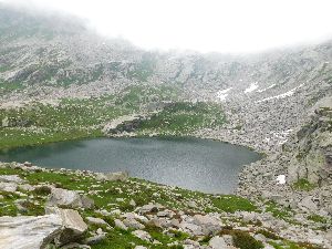 The Alpe Maccagno (WN07911) was no longer operated in 2019, possibly due to the current condition of the hut. Just before the hut, you have to cross a river (WN07910) using the high stones. The path leads you to the vicinity of the hut, and leads you immediately away from it to cross the same river again, using again some high stones. Nowadays there is a shortcut (WN07912). You walk along the western side of the lake at the Alpe Maccagno. Then you return to the main river to cross it near GPS WN07914. Immediately afterward, the path goes up to Lago Nero (WN07916). From there, the path is better marked and goes up partly via blockwork to the Passo del Maccagno (WN07917).
The descent is very steep. Extending your hiking poles by 30cm is advisable. In the first part, you descend along a rocky passage, where you have to use your hands for a big step down. Then it turns into a grassy slope, with a mixture of stone, earth, and grass. The markings here are yellow. Past the stream (WN07918) in the deepest point of the bowl, you can already see the path to the next pass. In the middle of the bowl, you’ll find a signpost near a gigantic cairn (WN07919). From there on, you also walk on the Alta Via 1. After the second pass, Colle Lazoney (WN07920), the terrain is again rocky. The paint markings are very good here. You walk through blockwork, usually with flat stepping stones. At the last signpost before the third pass, the Alta Via 1 turns right. The Colla della Mologna Grande (WN07926) is 5′ straight on from here. You recognize the pass by the Tibetan pennants. From the pass, you can see the hut (WN08000). Along the way, you’ll find a lot of blockwork, mostly with flat stepping stones. The entrance to the hut is on the right hand, the kitchen is on the left.
Rifugio Rivetti (WN08000): 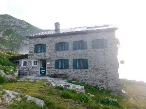

Tel: +39/015/2476141
Open: mid-June to mid-September.
Half-board in Dormitory: 40€ (2019)
Shower: 1,50€ 1/4L
Red wine: 3,00€
Soup: 6€ (in the afternoon)
Dinner:
1°: Antipasti
2°: Couscous, pork stew, zucchini, bean lettuce
Breakfast: from 7.00 am (in practice 6.30 am) Large can of tea or coffee, fortunately there is muesli, very dry bread or pre-packed toast with jam only.
Renovated sanitary next to the entrance, with one shower, 2 French toilets, 1 normal toilet.
Day 14 Rifugio Rivetti – Rifugio Savoia 19,5km +900 -1725
With rest: 6h45′, without rest: 6h15′ (with lift (2019))
With rest: 8h30′, without rest: 8h00′ (without lift (2012))

 The descent goes smoothly down to the first Alpine hut. On your way, you’ll pass the Alpe Lavazey with the ruins of the previous Rifugio Rivetti (WN08001), which was destroyed by an avalanche. From the next hut (WN08004) on, you will find a mule and cattle road with cobblestones. It is very difficult to walk to Piedicavallo, because of these cobblestones and when the stones are wet and slippery because of the rain, it only gets worse.
At the end of the path, you arrive at the main road in the village. You can either go further to the right, direction parking and bridge over the river. There you will find the beginning of the path to the Madonna della Neve. From the street, you can see a material lift that ends in a bare pass between the trees. That’s the Madonna della Neve. This is especially a destination for day-trippers from Piedicavallo. Personally, I find the number of additional altimeters too large and moreover they are avoidable by road. In Piedicavallo itself, only bars and a regional specialties and souvenir shop are to be found. So here you better follow the main road 3km to the left, to descend to Rosazza. Here too, no grocery store was found.
Walk through the village of Rosazza, at the end of which you take the well-signposted turn-off to the Santuario San Giovanni (WN08012). Follow the asphalt to the beginning of the hamlet of Gliondini (WN08013). Here you can leave the asphalt for the first time on your way to San Giovanni Sanctuary. You walk between the houses of the village and at the end of it, you briefly descend in the direction of a bridge that you cross. On the other side you turn left along the river and a little further (WN08014 Path up) you come at a fork in the road between a rising and a falling road. You won’t find any indication here, but logically you’ll take the uphill forest road. The road usually stays close to the asphalt road. Usually, the historical road is relatively wide, except in one place, where it is partly narrowed by the slope of the carriageway higher up the slope. You pass the Cappella di Santa Maria Magdalena (WN8016), where you also ignore the path down. Just before the Santuario (WN08017) you return to the asphalt road.
Turn right in front of the entrance of the Santuario (WN08018). At the back of it, take a road (WN08018A), which goes underneath the most uphill road. This road passes through the hamlet of Case Gamma. At GPS WN08018B you return to the main road, which you follow until you come across a large building (WN08020 (former hotel?)) in a hairpin bend. Here you will find a signpost (WN08019) and an indication GTA. Take the grassy road underneath the building. At GPS WN08021 (turn not left) you will find the junction between the low variant, which goes around the mountain (turn left, described in Rother) and the original GTA trajectory, which goes over the mountain. If you want to cross the mountain, continue in the same direction and go up a wide forest road until you reach the asphalt again (WN08022 Signpost). Here you follow the asphalt to the left. Further on you’ll find 2 more shortcuts from the asphalt, which were already very steep, but have become totally unusable due to recent forestry (WN08023). In the penultimate hairpin bend (WN08023), you’ll find the beginning of a usable longer stretch of path, which will lead you back to the road (WN08024) at the boundary of the tree line. On the left-hand side of the road, you will find the Locanda della Galleria Rosazza (WN08024A), a hotel with a view, which provides organic meals. However, the path crosses the road and climbs in the flank of the hillside in the direction of a stone stable (WN08025). From this stable, you can see an almost horizontal road in the direction of the pass. The stable is no longer exploited today, which results in very long grass, which makes walking and orientation difficult. From the barn, the road widens and the long grass doesn’t bother you as much.
Once on the Colle della Colma (WN08026), you have a view splendid over the Santuario di Oropa (WN08035). You descend from the pass to the right. You enter the forest and just above the Cascina Orone (WN08027 – ruin), you’ll find at a very short distance 3 signposts that will lead you clockwise around this ruin, to go down left at the third one (WN08029).
Finally, you arrive at the asphalt road, coming from the Locanda della Galleria Rosazza. The choice of the route you make now is mainly determined by the fact whether you want to stop in the Santuario di Oropa or whether you take the cable car up towards the Rifugio Savoia in the evening. In this case, you go to the left, slightly up until you find 100m further a descending path to the right. The mountain station that you can see from the Santuario di Oropa is not that of the Rifugio Savoia, nor that of Capana Renata, but the Bergstation on the Monte Mucrone that has been abandoned for 40 years. If the top of the mountain looks a bit white, that’s important to know :-). If you still have the energy to walk to the Rifugio Savoia, turn right here and save a few meters of ascent. Follow this road downhill until you reach a wide forest road (WN08031), with signs indicating the Rifugio Savoia. First, there is a path from the left that comes from the Santuario di Oropa (WN08037). Further on you will find a yellow marked path, indicated as Oropo Verticale, a climbing- and Via Ferrata-area.
A bit further the road crosses a rather wide stream, when it rains, using the high stones. Just past this crossing, you leave the wide road, which is locally in very bad condition, for a pretty good path that climbs the flank in a zigzag up to the Rifugio Rosazza /Mucrone (WN08038).
Rifugio Rosazza /Mucron:
Claudia Comello
tel 0039 339 460 2133
mail info@rifugio-rosazza.it
This is not a CAI hut, as claimed in the Rother guide. The inside looks a bit primitive, and the Rifugio Savoia is certainly a better place to spend the night.
From the Rifugio Rosazza, you climb a little further up to the end station of the cable-car, to continue horizontally to the Rifugio Savoia (WN08100).
Rifugio Savoia (WN08100):
Walking time without rest: 8h00′ with rest, 8h30′ (2012)
Piazzale Funivie, 6 – 13900 Biella Oropa (BI)
Tel. 015/2455929 – Fax 015/8970515
Open: early July to early September.
Prices 2012:
Half-board in room: 39€
1/2L Red wine: 3,00€
Bar: 2€?
Dinner (19.30h):
1°: Anti-paste
2°: Pasta
3°: Grilled meat with vegetables
4°: Cake with tea or coffee
Breakfast: from 7.30 AM Fresh croissants bread, jam, chocolate, honey, tea or coffee
Room of 4 with shower and toilet in the room, no sheets, own sheet bed-liner to be used, but with towels were supplied by the cabin.
Note:
- In 2012 I was the only real guest here, so I ate at one table together with the owner and the cook and the lift attendant. Traveling alone… it sometimes has its advantages.
- In 2019 there was a meeting of the local Alpine club, with the result that there was a sea of often very drunk people. Moreover, the Rifugio Savoia was full that weekend and the staff was very stressed by the crowds. Not very attractive as an area, so I went even further to the Rifugio Coda (2h30′). Luckily I had gone up by cable-car in 2019. The combination of climb and sequel would have been too much, after a start from the Rifugio Rivetti.
Day 15 Ref Savoia – Trovinasse 13,9km +750 -1250
With rest: 6h45′, without rest: 6h15′
 Leave the Rifugio Savoia (WN08100) through the front door and turn left to the signpost. Here you turn left again via the wide road to the Lago di Mucrone. If snow falls here at night, the road turns into a shallow brook. Further on, this road descends into the valley. This is the road you could see on the other side of the valley yesterday during the climb. However, you leave this road at a signpost (WN08101) to the right, just past a side stream. First, you pass the Lago di Mucrone, a picnic area on sunny days. 80m further there is an exit to the Colle Chardon. Further on, the path to the pass has been redesigned with beams to prevent erosion on the shortcut, but in fact they promote the use of the shortcut instead of the original path.
Just past the Bocchetta del Lago (WN08104) you turn right, and follow a well laid out path on the side of the mountain. You don’t lose much height. Only in the last part just before the Rifugio Coda, you gain altitude. Here you will find a number of passages, which are secured with ropes and chains. Especially in an intermediate descent, these aids can be used.
And then suddenly you’re at the Rifugio Coda (WN08109). For those who slept in the Rifugio Savoia (WN08100), it is too early to stop. But since I did this in combination with the previous stage, I spent the night here.
Rifugio Coda (WN08109): 
Tel: +39/015/2562405Tel: +39/370/3266366
Open: early July to early September.
Prices 2024:
Half-board in a dorm/room: 48€
1/2L Red wine: 5,00€
1,5L water: 2,50€
Shower not charged because of problems with the geyser (cold).
Dinner (20.00h):
1°: Pasta – Minestrone
2°: Large chicken leg with beans, potato macedoine, and lettuce.
Breakfast: from 6.00 a.m. (officially from 7.30 a.m.) Typical Italian (all packed): toast, cookies, jam, chocolate, tea or coffee.
Room of 4 (next to the plumbing and so much night noise), no sheets, own bagliner to be used.
 The signs in the vicinity of the hut are of little use because they all point you to the valley. From the front door of the hut, you start at right angles to the front facade in the direction of 2 columns of stacked stones (cairns) to a small pass (WN0811).
This path is about the opposite of the path you followed to the Rifugio Coda. Here you walk on the ridge, or close to it, and that means a lot of going up and down. You are also walking on the border of two Italian regions, which means that neither of them wants to take responsibility for who is going to maintain the path and so I have never seen such a cacophony of different colors of characters before, with the common characteristic that none of them has been refreshed recently. The path itself is narrow, often overgrown with grass, which makes it sometimes difficult to see and, moreover, in a number of strategic places on the path you have to deal with mainly goat manure. In the difficult passages, the path is secured with brackets, rods or rope.
Just after Colle Di Carisey (2142m) (WN08111) you will find the junction (WN08113) between the GTA and the ridge route of the Alta Via 1. The path of the GTA is heavy grown, especially in the flank of the Monte Bechit (2320m) (WN08114). You have to be very careful when placing your feet in this part. Just below the top of Monte Bechit (2320m) (WN08114), you’re back in more open terrain (WN08117), but you have to climb. Around an altitude of 2100m, you turn back into a traverse until you arrive just below the Colle della Lace (WN08119). From this point, you have to climb back to the confined building on the Alpe della Lace (WN08118), from where you climb to the Colle della Lace (WN08119) itself.
In 2012 the path of the GTA was closed and I had to follow the route over the ridge. At first sight, it seems more difficult than the GTA trajectory in the flank, but in practice this difference is negligible. From the junction, you will be directed towards Monte Bechit (2320m) (WN08114) and Monte Roux (crucifix at the top) (2316m – WN08116). Just before the top of the latter, you’ll be steered left around the top (WN08115) via a path secured with a thick bright blue synthetic rope, which will help you through the most difficult parts of the descent to the Colle della Lace (WN08119). On the Col, you’ll see a broken cow track straight down. On your right, you’ll find a path that goes in the flank of the mountain to the Colle di Giassit (with a cross).
On the Colle di Giassit, you don’t go down to the right, but you stay to the left of the ridge. You’re going down towards a farm. In front of the farm, you will be sent down to the left, via an already changed track, especially next to an electric fence. Rother’s GPS tracklog doesn’t add up here either. You now walk in a still wide clockwise curve around a small hill and the farm in the direction of the riverbed of the Torrente Chiussuma.
Lower you get to a cow track/path that comes straight from the Colle della Lace. With a bit of courage, and with good visibility, it is better to descend directly via this wide cow track/path that comes directly from the Colle della Lace.
Just before the Alpe Druer (WN08124), you reach an artificial cattle watering hole, where it is very swampy and the markings of the path are difficult to follow, and then you descend to the right via a slightly better path to a large cowshed on the Alpe Druer (WN08124).
Here you will finally find a drivable gravel road. You follow the slightly descending road in the right flank of the slope. Just before a second farm (WN08126 Alpette), you’ll find a signpost to Belvedere. You descend through an overgrazed and fertilized meadow towards a ‘path’ between the remains of two drywalls in the direction of the Torrente Chiussuma. At this moment it is best to aim at the bridge and find your way to the bridge (WN08127). You continue your way along the other side of the valley. First, you traverse at equal height to a hut at the edge of the forest (WN08128), where you start the final descent. You end up at a house near a gravel road (WN08129). Through a narrow path next to the driveway of the house, you reach the road. On the road, you turn right downhill until you see a signpost (WN08130) at the beginning of a forest road. Here you turn left and descend to the Agriturismo Belvedere (WN08200).
Agriturismo Belvedere (WN08200): 
Tel: +39/0125/658731
+39/333/2415816
Open: from May to October.
agribelvedere@alice.it
Full-board in a room: 50€ (Half-board: 42€) (some mattresses need to be replaced :-()
Red wine: included at the table.
A large bottle of beer 66cl: 4€ (33cl: 3€)
Lunch (13.00h):
1°: Pasta
2°: Pizza
3°: Cake
Dinner (19.30 to 20.00):
1°: Anti-pasta: chestnuts, vitello tonato, paprika, veal tongue in tomato sauce
2°: Lasagna Verde
3°: Brassato, lettuce, puree.
4°: Fruit or sweets.
Very large portions.
Breakfast: from 7.30 AM: Horn of plenty.
Room with 2 bunk beds, shared shower and normal toilet in the hallway.
Original description GTA 2012:
Day 16 Trovinasse – Le Capanne 11.8km +1109m -1170m 4u45′
Walking time without rest: 4h45′ with rest, 5h30′ (shopping in Quincinetto)
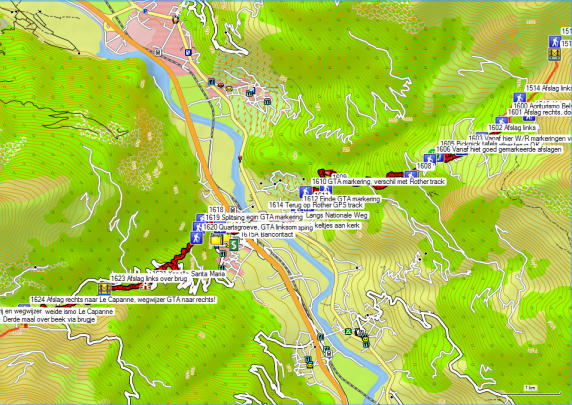
 You leave the Agriturismo Belvedere (GPS1600) via the road underneath the concrete wall, which makes the terraces what they are… flat. At a house you turn right and then you go diagonally left through the meadow, in the direction of two historic arched bridges, which are difficult to see because of the vegetation and the trees. There are a few yellow arrows hanging on the trees to clarify the road. Once over these bridges, everything is perfectly marked with paints and signposts by the Regione Piemonte. Just after a house with a small vegetable garden (GPS1603), the GPS steers you to the right. This route goes down a vague road and then reaches the asphalt more quickly. It is better to follow the markings and the road to the left here. Contrary to what is stated in the Rother-guide, the present state of the way markings (2012) is good. You descend via a mule track, which is in very good condition and therefore not too stressful for the feet. From GPS1604 on, the way markings and the Rother tracklog coincide again, until shortly before Quincinetto and more specifically GPS1610. Rother follows a route via Airale. The GTA markings lead you down through Torredaniele. At GPS1612 the markings stop and you continue along with the asphalt in the direction of ‘centrum’ and then on to the main road. This variant stays a bit longer away from the asphalt, but you have to follow the main road (SS26) into the valley over a short distance. At the bridge over the river Dora Baltea (GPS1614) both variants come together again. First, you cross the stream, and then the motorway, both via a bridge.
You leave the entrance to the motorway to the right and then you go straight on through the narrow streets towards the church into the village.
If you need to replenish your cash supply, turn left, right next to the motorway entrance and follow the signposts for ‘Town Hall’. On the corner of a strange square with shops and a bank, you’ll find an ATM (GPS1615A). In Quincinetto you will find next to the ATM also 3 small shops, to replenish your stock. (2 at the church, 1 on the square just past the hotel.)
Immediately past the church, you can turn right. Follow your GPS tracklog, for a moment. At GPS1617 you will find new markings of the GTA. 
You immediately start the climb through the forest. At GPS1619 you’ll find a fork to the right over the bridge. You stay on the same bank and continue straight on until you reach the entrance of the quartz quarry. Attention: the GTA does not go through the quarry, but counter-clockwise via the road (GPS1620). Don’t break your legs during your visit to the quarry :-(.
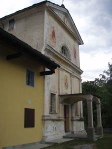 Higher up, you reach a driveable road. Here you always cut short the hairpin bends, but sometimes you have to look carefully to see the beginning of these shortcuts. The chapel of Santa Maria (GPS1621) is in good weather a nice place for a (meal) break. Shortly after the chapel, you return to the road, which you follow until you reach a chapel (GPS1622), in a hairpin bend in the road. Here you leave the road, by crossing the mountain stream via a bridge (GPS1623) and on the right bank of the stream you climb up further through the forest. Higher up, you cross the road twice, before you arrive at a signpost on a country road. The GTA signs point to the right in the direction of Scalaro. Unless you stayed overnight in Quincinetto, you turn left here towards the Agriturismo Le Capanne (GPS1700).
Agriturismo Le Capanne (GPS1700):
Walking time without rest: 4h45′ with rest, 5h30′ (shopping in Quincinetto)
Tel: +39 0125 757397
Mobile: +39 333 8279078
nicolamonettalecapanne@yahoo.it
Open: early April to early November.
Half-board in a room: 40€
1/4L Red wine: (included, full-bodied dark local wine from Biella)
Dinner (19.30h):
1°: Anti-paste
2°: Pasta with tomato sauce
3°: potatoes, stew, tomato
4°: Fruit and cheese
A little more measured than in Belvedere.
Breakfast: from 7.30 am Traditional Italian breakfast with bread, jam, coffee or tea.
Room with 2 single beds, TV, private bathroom with shower and normal toilet suitable for wheelchair users. The central heating was lit, given the rainy weather. Towel drying radiator, which was ideal to wash my clothes and also get them dry :-).
Note: A good place to stay, for those who love peace and quiet. Children’s playground. More luxurious, but a little more businesslike than Belvedere.
Day 17 Le Capanne – Fondo 12.4km +869m -1153m 5u00′
Walking time without rest: 5h00′ with rest, 5h15′

 You leave the Agriturismo and walk around the outside of the stable. Follow the road and the markings on a ridge between 2 streams along the electricity line, until it bends to the left. Here you go to the right and follow a horizontal traverse up to a stream, which you follow up. You cross the stream 3 times: 2 times without aids and once via a bridge (GPS1701), close to the road. You don’t reach the road, but you cross a meadow again in the direction of a higher part of the road. Here you cross the road to climb diagonally through the meadow to a signpost in the middle of the meadow, without any visible purpose (GPS1702).
From here the path itself becomes more difficult to follow, because of the many tracks that were made by the cows. In principle, you always walk in the direction of an elevated stable or alpine farm. This is the case with both GPS1703 and GPS1704. Here you arrive at a road, which is not on the digital map. You go to the left, away from the bridge and follow the road up towards a third Alpine farm with a dark green painted part, but you leave the road at a signpost to the left. You won’t find that many paint marks here (GPS1706). After a while, you reach a tractor track, which you leave again to walk towards a tube bridge (GPS1707) in the shortest way. Here you follow the road again in the direction of the remains of a stable. You leave the road for a path (GPS1708). The path climbs easily towards the Colle di Pian Spergiurati (GPS1710), which is somewhat hidden behind another highest point (GPS1709).
 On the col, you’ll find cows. From here the path goes almost flat to the Rifugio Chiaromonte (GPS1711). The cabin itself is closed. There is a text in three languages on the door, that you have to pick up the key to the self- service hut in the Alpe Chiaromonte (GPS1712), not 5′ but in reality 10′ further.
At the Alpe, you are offered coffee. In the horizontal part up to the 2 drinking troughs, you have a lot of trouble with cow tracks. At GPS1713 you will find the path to Traversella and the Rifugio Brunno Piazza. The path is very badly marked. Further on, the path remains narrow and suffers from overgrowing grass. This is the case until the path begins to descend. Lower down the slope you pass a third Alpine hut, which is in good condition and is used by a shepherd. In the descent, the slope is grazed by the sheep.
At GPS1714, the path disappears below the tree line. You pass through a ghost village and follow the now clear markings between the houses. You descend to a fork in the road where you go straight ahead. Then the path goes up slightly, and down again to the bridge over the river. After the bridge, the path climbs back to a second village, where a number of houses have been restored and are used as holiday homes. At the end of this road you turn right (GPS1715). The path descends to rise again just before the waterfall. At the bottom of the waterfall, there is a long wading passage (GPS1716). Especially in rainy weather, you have to be very careful here. After the passage underneath the waterfall, the worst of your ordeal is over and you can easily descend to the Trattoria del Ponte (GPS1800).
Trattoria del Ponte (GPS1800):
Manager: Luciana Bertolino
Tel: +39 (0) 125 749124
Mobile: +39 3488891454 (om te boeken: zend messages via Whattsapp)
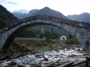 Open: all year round.
Half-board in room: (No recent prices online)
Dinner (20.00h):
1°: Risotto
2°: Sausage with vegetables
3°: Fruit or cheese
Lunch:
1°: Pasta ragou (Bolognaise)
2°: Pork chop with salad
Breakfast: from 7.30 am Traditional Italian breakfast with bread, jam, coffee or tea.
Room with 1 double bed and 1 single bed, common bathroom with shower and a normal toilet.
Maintenance leaves something to be desired. Check the sheets!!!!!!! They’re hanging out to dry, and a bird might defecate on them. Lots of life between the inner and outer roof. The adjoining part is under renovation. I suspect a big bird made his nest under the roof above the bedroom.
Note: again 2 old people. How long will they last? Their daughter will take over the business. Age does explain something about maintenance, etc.
Day 18 Fondo – Piamprato/Ronco 11.8km +1343m -863m 5u15′
Walking time without rest: 5h30′ with rest, 5h45′
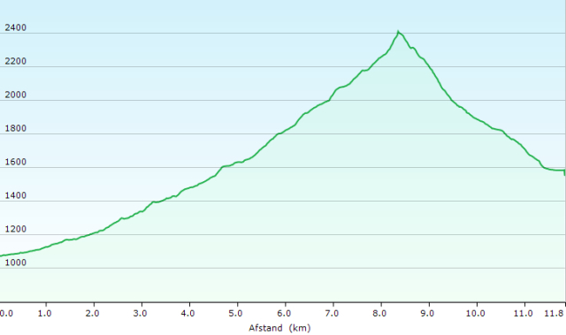
 The climb to the Boccheta delle Oche is relatively easy. Just before the first Alpine hut, there are old and new markings, where the trail is slightly different. At least you’ll have to pass by the cabin. After the hut, you have to follow the road to the second hut. Do not try to follow the old paint markings and the GPS tracklog which will lead you through the quite swampy meadow. So you don’t gain anything by not walking along the road. After the second alpine hut, you leave the road at GPS1802 to go up along a tributary stream. At waypoint GPS1803 you have to wade carefully through the river. At waypoint GPS1804 you change riverbanks again, but this time the bed is very shallow, so there are no problems with wading here. In the next part, you have to keep a close eye on the path because the course is not always clearly visible in the landscape. You walk from one paint marking to the next, without it being clear whether you are walking on a path or on a cattle track. The last part of the climb is strenuous because the path goes straight up to the pass. After 3:30, you reach the top of the pass.
Make sure you grab some calories on the pass because the following descent is nerve-racking. The path is very steep and very humid. This means that the vegetation here is lush and that you cannot see the stones on the path very well. Due to the high humidity, these stones are also slippery. The path also runs close to the river, so any slip can have major consequences if your fall is not broken by the presence of shrub-wood. 2 stretches of path are secured with a rope. The use of the rope is absolutely necessary, because of the humidity and slipperiness of the rocks. The last rope should be used as a descender rope, holding it between the legs in order to bridge 2 altimeters. After 1 hour you arrive at the river, which you ford to the other side (GPS1806).
The next part doesn’t descend so steeply anymore. The path still runs close to the river. Several narrow rock passages are secured with chains. After half an hour the path goes away from the river (GPS1807), and finally, it becomes a normal path. At waypoint GPS1808 you arrive at a T-junction, without any indication. Here you go to the left downhill towards the valley. The end of the path is a wide unclear area next to the riverbed. You pass a fit-o-meter and continue along the river towards the road. Here you turn right over the bridge, past the church until you reach the Aquila Bianca (GPS1900), located on the left behind the church at the ‘village square’ (30′).
Aquila Bianca (GPS1900):
Frazione Piamprato – 10080 – Valprato Soana (TO)
Tel. +39/0124/812993 – 0124/68322 Fax. 0124/812993
E-mail info@locandaaquilabianca.it
Open: all year round.
Half-board in room: 110€ is too expensive!!!! (2024 via Booking.com)
1/4L Red wine: 3,50€
1/2L Red wine: 4,50€
Cheese: 3,50€
Dinner (19.30h):
1°: Anti-paste (small)
2°: Pancake chips with cheese
3°: Braised trout with lettuce and polenta
4°: Cheese (3’50€ extra)
Breakfast: from 7.30 am Traditional Italian breakfast with bread, jam, coffee or tea.
Room with 1 double bed, 1 bunk bed & 1 single bed, TV, private bathroom with shower and normal toilet. Pellet stove and air conditioning unit in the room. Pellet stove is too noisy to leave on at night. By far the most expensive, but certainly not the best.
Taking the evening bus seems sensible.
Day 19 Ronco – Talosio 12.7km +1187m -903m 4h15’+bus
Walking time without rest: 4h15′ with rest, 4h30′ bus ride: 45′
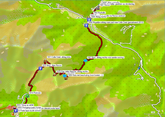
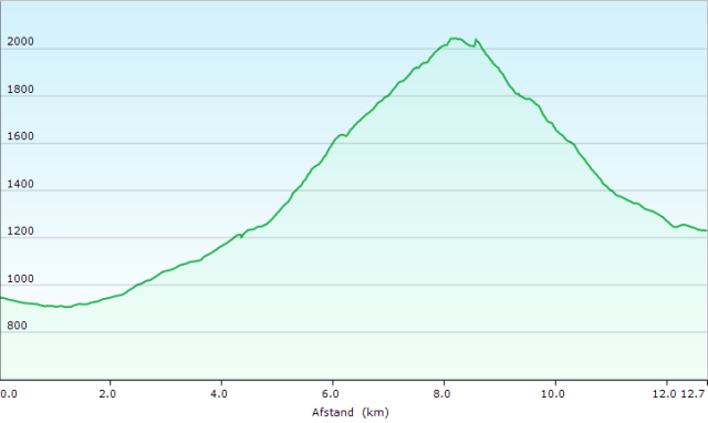 Officially the bus to Ronco leaves at 09.20h and 17.30h. In practice, this is more than 10′ later. Especially in the morning, the driver has to drink his coffee in the Aquila Bianca before he can start the descent.
Along the way you pass Lo Moderno, Via Valprato 41, Ronco Canavese, (GPS1900A) the pizzeria and rock café mentioned in the Rother guide.
From there it is a short drive to the finish in the center of Ronco. You’ll be there by 10:00 AM. (GPS1901) A ticket is bought on the bus.
In the town, you will find next to a pharmacy (GPS1900B), 2 food shops (GPS1900C & D).
Bank without ATM.
In the towns center you will find:
Locanda della Luna:
via Alpetta
10080
Ronco Canavese (TO)
No prices to be found online.
600m before Ronco you will find:
Lo Bec:
Handy: +39 349 3636611
Bed: 20€ Room 75€ via Booking
3km before Ronco in Valprato Soana, you will find:
Phoenix Hostel:
Tel. +39 (0) 124 373288
Mobile: +39 338 4275195
Bed: 25€ via Booking.com. Less interesting because of the location.
From the bus stop (GPS1901) walk downhill to the bridge over the river (GPS1903). Across the bridge, do not take the first street to the right, immediately after the bridge, but the second narrower street, 60m further along the main road. The route mentioned in the Rother-guide follows this road until the end at GPS1907.
If you look closely at the map in the Rother guide, you will see a dotted line from the hamlet of Bosco (Pinera on the GPS map) to the Colle Crest. In Piamprato I spoke to a park ranger of the Parco Nazionale del Gran Paradiso. He told me that the path is used by hunters and that in the week following our conversation (September 2012), the path would be marked again. On my passage over the Colle Crest, I found a signpost and paints on the pass in the direction of the valley (Bosco, Ronco). If you’re a bit adventurous, you should take a look at it. You’ll save at least 3km of steep asphalt. The path runs partly inside, partly outside the park, so the chance that it is or remains in good condition is greater than outside the park.
But since I assumed that the other route was not yet marked, I stuck to the Rother variant.
You follow an almost car-free stretch of asphalt for 3km. The asphalt is mostly in the shade, but it is very steep, almost like a mule track. The standard vehicle here is a Fiat Panda 4×4, which is no superfluous luxury. At GPS1907 you are at the end of the asphalt. Just past a well and just before the wall of a house, the GTA goes up on the right and then passes behind the houses. The path runs on the left bank of the Guaria up to a first tributary. Here the path leaves the river and then zigzags up through the forest. Once you leave the forest, you are confronted with a multitude of animal paths, making it difficult to find the right path. Due to the long grass, a number of markings are not easily noticed, as they are often placed close to the ground. In addition, the distance between the markings is large. Fortunately, the GPS brings some relief. At the Alpe Goie you have to walk along the top of the hut. Then you zigzag to a small hut, and from there through a crevice between the rocks to the Pian delle Masche (Plain where the witches dance) (GPS1910). Here you don’t go left, but right up to the highest point, the Col Cima Rosta. From the pass, it goes downhill in the direction of the Colle Crest (GPS1911). On this Col, you will find better signposts and as mentioned before also markings towards Bosco and Ronco. Here you descend from the pass to the left (or straight on if you come from Bosco via the hunting path). The descent is better marked up to the Santuario di Prascondu. You don’t go to the church itself, but you descend straight on until you reach a chain, where you turn left over a small bridge (GPS1913). Here you will find a picnic table (GPS1914). You descend along a path between drywalls to the bridge over the river Ribordone. You climb back up to the road. You descend along the road to the village. Here you will find the café/restaurant (Trattoria GrisolanoTalosio) (GPS2000), wherein the house just in front of the restaurant you will find the manager of the Posto Tappa. This is the daughter of the parents who still keep the café/restaurant open during the day. She will lead you to the old school building, where the Posto Tappa (GPS2000A) is located.
Trattoria Grisolano Talosio (GPS2000):
Trattoria Da Marina / The Wolf
Manager: Marina and Luciano Grisolano
Tel: +39 0 124 818015
Mobile: +39 3409191958
Open: all year round.
Half-board in posto tappa: 40€ (2009) (expensive in view of the comfort offered in the Post Tappa)
Red wine: included
Dinner (20.00h):
1°: Anti-paste (large)
2°: Pasta
3°: Main dish
4°: Cheese and fruit
Breakfast: from 7.30 am Generous breakfast with bread, jam, coffee or tea, yesterday’s cheese and ham, biscuits, fruit juice, etc.
Posto Tappa (GPS2000A):
This is an old school building, with bunk beds on the ground floor and single beds on the upper floor. The ones upstairs looked like the “cleanest”. On the best beds, you’ll find a sheet covering the mattress and a horse blanket. The use of your own sheet and/or sleeping bag seems advisable. The overall impression is not favorable when it comes to cleanliness.
Amenities: shower with hot water, without a curtain, toilet without a seat, little toilet paper, main electricity switch on the balcony of the first floor. No possibility to lock up.
Note: it is advisable to explore the beginning of tomorrow’s route in the evening.
Day 20 Talosio – San Lorenzo 13.4km +1379m -1523m 6u15′
Walking time without rest: 6h15′ with rest, 6h45”
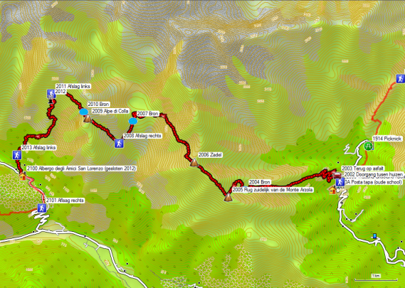
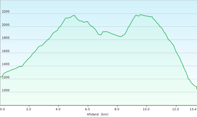 If you don’t have a GPS with you, it’s best to walk back to where you came on the road yesterday, and then turn left 75m further on an asphalt road to Posio, where you can find the GTA signs further down this street.
The normal Rother route starts via a narrow corridor next to Trattoria GrisolanoTalosio (GPS2000). You go up to the street, where the church (GPS2001) is located. Here you turn right to the church. You round the church in a counter-clockwise direction, after which you go through an arched passage between 2 houses (GPS2002). The path first runs behind the houses. Then it goes up, to continue horizontally to the left again. When you are about back at the position of the passage between the houses, the final climb through the forest towards the road (GPS2003) is started.
In 2012 they were working on a combination of sewers and improvement of the path. Rother’s tracklog continues to follow the lane here, but there are some shortcuts to cut off the hairpin bends. The path may be very steep. In Posio you walk between the houses to find a nice path, first through the forest, and then through the Alpine pastures. At the alpine hut (Alpe Arzola) you have to watch out for 5 to 6 dogs, which are not on a leash, and who are more awake than their owners. The latter had to put on his clothes before he could call his dogs to order. The path to the first saddle (GPS2005) is without any further problems.
 The path from this saddle up is rather narrow due to overgrowth. The signs are hard to see. After the summit, the path is fairly flat. At some point, you change sides on the ridge. You then walk to a small pass/saddle (GPS2006), from which you can start the descent. You have to pay attention to the signs. Especially in the second part of the descent, the soil is marshy due to the presence of streams. The path doesn’t run in a straight line to the stowage-wall but descends rather steeply in order to be able to cross the last tributary stream. It then finds its way through the bowl at the bottom of the stowage-wall. Upon arrival at the wall, you go to the left, in the direction of the building at the top of the wall. There is a path in zigzag and then stairs up until you reach the top of the wall. Here you follow the road to the left at the bottom of the building. You come to the second part of the wall, where you follow the road over the wall. Beyond the stowage wall, the road makes a hairpin bend to lose height. When the weather is dry, you can take a path to the right. The last part runs over slanted rock slabs, which you better avoid when wet.
You keep on following the road until you find a side road and a signpost at some conifers (GPS2008). Here you go to the right. At first, the road climbs gently until you leave the road in a bend to follow a path straight up. The path is well marked, but the last part, just below the Alpe di Colla, is a true direttissima. On the pass, you will find a hut for the park rangers, which is closed. On the outside, you’ll find a water tap and a mirror.
Behind the pass, the path goes up and down a bit, up to the Alpe Praghetta (GPS2011). Here you have to be very careful not to miss the exit to the left. You are easily mistaken, following the path that rises further and runs along with the stables in front of you. You won’t find any signposts here. Due to the presence of cows, there is no really clear path. You descend zigzagging to a column of stacked stones to the left of the support of a material cable car (GPS2012). From there the path goes down in zigzag again. The path is very difficult to follow. The cows determine the path here and that means that it has dissolved and sometimes goes in all directions. You arrive at a stone building, where a signpost points to the left, while the white/red paint signs go to the right. Again it is a matter of looking for a path between the mud and the manure. Upon arrival below the tree line, you will find orange markings instead of the normal white/red ones. A little lower you will finally find a better path, which you follow to the right. You won’t find here any signpost worthy of that name either. For the people who come out of the valley, the only signpost exists of a wooden arrow with a metal plate of the Via Alpina. You descend along this good path to a riverbed formed by stone slabs. Here you turn left and a bit lower you turn left again (GPS2013) between drywalls. At the first house and chapel, you ignore the wide road behind the chapel but choose again a narrow path between drywalls that descends straight on into the village. In the village, you turn left on the asphalt to the Trattoria Da Livio di San Lorenzo.
Albergo degli Amici (GPS 2100) (closed in 2012):
Tel: +39/0124/800195
Alternatief volgens Folder GTA:
Trattoria Da Livio di San Lorenzo
Manager: Simona Reali
Tel: +39 0 124 800213
Mobile: +39 3475925546 – +39 3401260343
Reservation via +39 3475925546 – Overnight stay only after telefonic reservation.
Friday closed.
Accommodation available after reservation by telephone only .
Note: I had already heard rumors that the Albergo degli Amici was closed, but I was not aware of any alternative and as such did not have the data of the Trattoria Da Livio di San Lorenzo. I presented myself there but understood from the “mother” that they would not give me a room. Admitting… my Italian is not very good.
Day 21 San Lorenzo – Noasca 12.2km +833m -838m “Ca.4h30
Walking time as described above without rest: 3h00′ with rest, 3h15′.

Normal GTA Rout San Lorenzo – Noasca
Hoogteprofiel normale GTA Route San Lorenzo – Noasca
As I couldn’t find a place to stay in San Lorenzo, I descended via the road to Rosone in the valley, hoping to find a bus there, but it only runs to Noasca at 18.15hrs outside the school year. So I walked along the road (SS460) to Grusiner, where the GTA crosses the road (GPS2102). Here I started to follow the GTA again until Noasca. Following the path, you bridge a little more height difference than along the road, but the path is otherwise problem-free.
Albergo Gran Paradiso (GPS2200):
Sandro A. +39 340.4729334
Sabrina C. +39 334.3721183
Via, Corso Umberto I, 2,
10080 Noasca TO, Italië
Open: all year round.
Half-board in a room: (Suplement of 10€ for individual use): 90€
1/4L Red wine: included
1/4L Red wine: 2,50€ (if you are very thirsty ;-))
Dinner (20.00h):
1°: Anti-paste (large)
2°: Pasta
3°: Meat or fish (meat is the better choice here ;-), the fish is acceptable) with fries and salad 4°: dessert or fruit
Breakfast: from 7.30 AM. (in practice 08.00 AM, as Italians have a hard time getting started in the morning). Very large breakfast with croissants, bread, jam, cheese, salami, fruit juice, coffee or tea.
Room with 2 single beds, common shower, and normal toilet. Rooms on the street side have some noise from the traffic (single glazing). In rooms along the riverside, you can hear the river.
Day 22 Noasca – Ceresole Reale 10.0km +1017m -565m 4u00′
Walking time as described above without rest: 4h00′ with rest, 4h20′.
After yesterday’s marathon :-(, this feels like a day off :-).

 Leave the Albergo Gran Paradiso (GPS2200) via the main road to the left. Follow the road up through 4 numbered hairpin bends, and then leave the road at the second signpost (GPS2201).
The first part of the climb rises quite brutally. You end up on asphalt, where you go up further, but at the first house, you leave the asphalt again, via a not so clear path. The idea here is that you first go up a few meters parallel to the asphalt, and then go to the left between two drywalls. The markings here are not optimal. It is a kind of mule track that you follow until you reach the next signpost (GPS2202). From there on, you go up a gravel road (GPS2203), where work was done in 2012 to widen it, probably up to a drinking water collection point. Because of those works, I didn’t find any signs here. From GPS22004 I found them again and further along the path no problems were encountered.
 You pass several hamlets, most of which are deserted. Especially in Maison and Capelle, you should take a look around. In Maison, the path passes an old school with the original wooden desks, the teacher’s desk, and in the room behind it, even the bed are still present in the original state. This looks like a scene from a local museum. After Capelle, the trail goes slightly downhill until the bridge (GPS2209) over the river that comes from the waterfall. From here on, you walk in the direction of the wooded mountain flank, to start the climb. At first it’s quite brutal, but later on the inclination decreases. Once at the top, there is a fairly long traverse to Pra del Cres (GPS2210). The signpost here is unclear. You take the descending path to the left, to end up at the Casa Bianca (GPS2211) a little later (5′) (Only the facade is white :-)). On the other side of the valley, you can see the Colle della Crocetta (second from the left). From here a wide path descends through the forest in the direction of Ceresole Reale. At GPS2212 you will find another signpost. On the right, you go to the center of Ceresole Reale, on the left to the Fonti Minerali.
If you still want to do some shopping or need cash, you better go to the right here. The ATM can be found in the sidewall of the post office, at the end of the village. You’ll find many hotels, restaurants, cafes, and even a souvenir shop, but no food shops. Typical for a tourist trap :-(.
If you turn left at the signpost (GPS2212), you’ll arrive at a small parking lot at the end of an asphalt road. This will take you down to the main road, where you will descend to the left. After the hairpin bends, you will find in the next bend on your right a newly constructed road with a railway track, where you can already descend towards Fonti Minerali. At the end of this road, you’ll find another signpost, where you turn right until you reach the bridge (GPS2216) and the Albergo Fonti Minerali (GPS2300).
Albergo Fonti Minerali (GPS2300):
Borgata Fonti Minerali, 1
10080 Ceresole Reale
Torino – ITALIA
Open: May until the end of September.
Overnight stay in a dorm room (exclusively for you, if possible): 50€ Individual room: 60€
Dinner: best option: small salad + pizza of your choice + dessert + 1/4L red wine
Breakfast: Any time you want. It’s ready.
Obviously too lazy to get up :-(. Coffee or tea in a thermos, not very warm after 9 am.
O,5L for 2 persons. In addition, the tea bags are left in the water all night long instead of 4 to 6′. Green tea requested. Pale normal black tea with vanilla flavor :-(.
Dry bread (again :-() jam, cake, cookies, a small bowl of muesli with pink yogurt.
Room with 2 bunk beds, no sheets, common shower, and a normal toilet. Towel. Rooms are quite humid due to the lack of heating and the fact that the building remains in the shade of the hillside for a long time.
Note: In the basement under the sleeping area there is actually another source (Fonti Minerali), but right next to the river… purity, water quality?
Day 23 Ceresole Reale – Pialpetta 12.9km +1142m -1486m 5u20′
Walking time without rest: 5h20′ with rest, 6h00′
 You go up along the ski slope to the top of the dam (GPS2301). Along the way, you pass traces of a primitive iron-smelting furnace. Once on top, don’t cross the dam, but continue along the lake, via a wide gravel road, past the barrier to the second signpost (GPS2302). Here you go up left via a path. On the signposts, you will find the Colle della Crocetta and Balme. This is not tomorrow’s final destination, but the name of an Alpine pasture of the same name on its way to the Col. The path is in good condition and well marked. Sometimes the direttissima are clearer than the original path. After all, we’re in Italy…
The course of the path is quite complicated. The Colle della Crocetta with its cross is only visible late. If you are still walking on low shoes, a shoe change at GPS2305 is recommended, as this is where the block-work zone begins. This climb up to the Col is tiring. On the Colle della Crocetta (GPS2306), next to the already mentioned cross, you will find a Pass-book, in which you can write your name and other outpourings.
The descent up to the first Alpine hut that can be reached by car is easy. Further on, the path becomes a little vaguer. In 2012 fallen trees were hindering the passage along the path. You go straight on, parallel to the vague track to the huts, but a bit higher on the mountain flank. You have to keep an eye on the signs until you descend to the left in the direction of a small building at a bend in a gravel road. You cross the road and descend straight down in the direction of the forest. You continue through the forest until you reach the beginning of an asphalt road. Rother’s GPS tracklog follows the asphalt from here. The GTA marking follows a field road underneath the asphalt, but this is not so clearly indicated locally. You arrive at an intersection. On your right, you will find a large information board together with signposts. The GTA is not clearly indicated here. You descend straight on in the direction of a white church, Cappella della Visitazione (GPS2309). From this church, you can also see the Colle di Trione (GPS2405), where you will pass tomorrow.
At the church, turn left. You follow a path, partly between drywalls. You cross the road several times. Here and there you have to pay attention because not everything is well marked. When in doubt, your GPS delivers you a definite answer. From a building with a large statue of Christ at the back, the Rother tracklog differs with the GTA markings and signposts on site. The paths followed are sometimes narrow, but the indications are good. The big advantage is that you don’t have to follow the asphalt so much. You arrive in the village near the Albergo Pialpeta (GPS2312). This inn is significantly more expensive than the Albergo Setugrino and moreover, they were not very friendly. I arrived there on a Sunday during the rush of the lunch service. The Albergo Setugrino (GPS2400) is located on the main street to the left.
Albergo Restaurante Pialpetta:
Piazza S.Lorenzo 1 Fr. Pialpetta, Groscavallo, Italy
+39 377 083 0868
albergopialpetta@hotmail.com
The first thing you see is a sign for Illy (coffee). The room was reserved by telephone from the Albergo Fonti Minerali. In the village, you will find a grocery and a butcher shop (GPS2311A), which is even open on Sundays. Finally, a place to replenish your shrunken stocks. 🙂
Hotel Setugrino (GPS2400):
Hotel Setugrino
Manager: Giuseppe Berardo
Tel: +39 0 123 81016
Mobile: +39 333 3442853
Corso Roma 10, Groscavallo, Italy
Open: May to October.
Half-board in a room: 50€ (2009 – No actual prices online)
1/2L Red wine: ( the least good wine of the whole trip)
Dinner (19.30h):
1°: Lasagna Vegetariana
2°: Soup
3°: Pork chop with potatoes and vegetables
4°: Dessert (cake or fruit)
Breakfast: from 7.00h Breakfast with bread, jam, honey, coffee or tea, fruit bowl
Room with 2 beds, TV, private shower and a normal toilet. Rooms 7 & 8 at the rear suffer from the noise of the compressor of the freezer in the kitchen under the rooms.
Day 24 Pialpetta – Balme 14.6km +1634m -1161m 6u45′

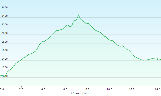 You leave the hostel via the main road to the left until you reach a small park near a stream. Here you will find a signpost to the right. Follow the gravel road to the bridge over the Stura Di Valgrande. On the other side, you take the ascending road to the right, which you soon leave via a path uphill to the left. The path is rising very fast. Then there is a section of traverse, where you stay almost at the same level and a number of brook beds to traverse until you arrive in the right gorge. Here you will climb to the first Alpine hut with cows. From there it goes uphill again, after which there is a traverse along with the second Alpine hut. At the third alpine hut, you pass along the lake. Then you have to be very careful. In the vicinity of a relatively large white/red sign, do not follow the unmarked path straight ahead, but an almost invisible path that disappears between the bushes. Then follows a traverse, in which you even descend a bit back into a bowl, until you are almost back above the previous hut. Here the path once again takes on the climb between the bushes. You almost need a machete to make your way through the bushes, which slowly overgrow the path (GPS2404). Then there’s some scrambling to be done until you finally end up in the bowl under the Colle di Trione. First there is a zone with very large flat stones, which makes you wonder how many people it took to lay them out so beautifully. At the end of this part, the path zigzags to the right of the block field up to Colle di Trione (GPS2405) (4h00′).
 The descent is very weakly marked. The first part, up to a half-dried-up lake is still pretty good. There is a good chance of spotting both ibex and chamois here. After this lake, you detect the path continuing in the direction of the pass. Later on, the path fades. You pass the first Alpine hut (GPS2406), where the path continues to traverse to the left and then descends between the cow tracks.
First, it goes straight down, and then diagonally to the right, in the direction of a second Alpine hut. Here you continue to the left in the direction of a mountain stream, where I found a metal signpost of the GTA again. Further on, you descend via a vague path that disappears quickly, until you see a stretch of path to your right again. You pass back through the riverbed again. From here on, you will find some path in the direction of the next hut (GPS2409). This is followed by an almost horizontal section in the direction of the next brook bed (GPS2410). You climb up out of the riverbed again to descend parallel to the stream until you find some clear signs again at waypoints GPS2411. A bit lower, at GPS2412 you will find another cabin, the first one that can be reached by car. You descend a little along a vehicle track until you leave this track to the right at the level of a sign. Here you descend into the flank until you reach the road (GPS2413) again. You can also follow the vehicle track through the meadow to reach the beginning of the road and get back to the intersection with the path.
Attention: do not follow the vaguely marked path (GPS2414) that descends to the left, but follow the road until it climbs a second time. Left, down in the valley, you’ll see stables and a path that descends in the direction of those stables (GPS2415). This is the path you need to take. From here it is finally well marked, although the course of the path remains erratic. At waypoint GPS2416, you can reach an asphalted road and signposts. A little higher there are still a few signposts that don’t make you much wiser.
Once on the asphalt, you descend to the right until this road ends in a wider road, with a bad road surface. Here too you go to the right. You pass through the hamlet of Chialambertetto, where a bridge lets you cross the river. In 2012, the remainder of this road was closed off to car traffic due to landslides of the mountain flank. You could still pass on foot though. A little further the still passable road crosses the river to join the local street through Chialambertetto.
You continue past a bottling plant of mineral water until the first street to the left. Don’t look in vain for the Albergo Cammusot, because it has been closed since 2012. The new posto tappa is located on the road over the bridge to the left. Its name is Les Montagnards (GPS2500) (the landlady speaks French).
Les Montagnards (GPS2500):
Adres: Frazione Cornetti 73, 10070 Balme (TO)
Tel: +39/0123/233073
+39/347/3634082
Open: gans het jaar.
Open: 01/06/2019 to 30/09/2019 (GTA)
Prices 2022:
Half-board in a room: 58€ (anti-pasta is not worth an extra 10€) (Didn’t order it myself, but saw what the other GTA walkers got. But for the rest, absolutely no complaints. Very good cook even)
1/2L Red wine: 4€
Dinner (19.30h):
1°: Pasta Fungi
2°: Donkey stew (yes J) with mushrooms and salad
3°: Chocolate cake or Panacotta
Breakfast: from 7.30 AM. (In practice a lot later… Italians, they start slowly…) Breakfast with bread, toast, muesli, cake, jam, honey, fruit juice, coffee or tea
Room with 1 bunk bed, private shower and normal toilet (completely new of course).
Note: Check the invoice if you didn’t take an anti-paste… 10€ less.
Day 25 Balme – Rifugio Vulpot
18.7km +1739m -1432m 9u00′
Walking time Balme – Usseglio without rest, : 5h35′
Walking time Usseglio – Margone (estimated: 40′)
Walking time Margone – Rifugio Vulpot without rest: 1h00′

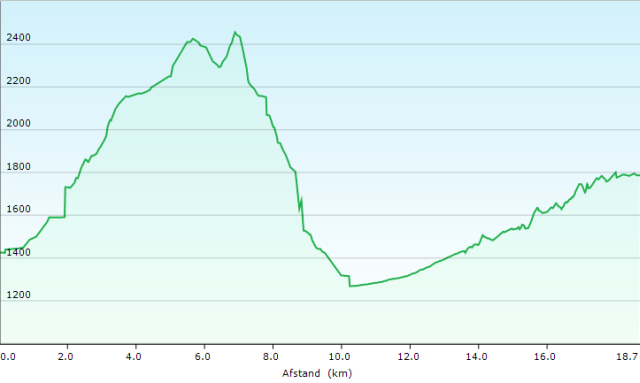
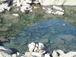 Leave the Posto Tappa (GPS2500) to the right. You can either cross the river on the first bridge, or you can walk to the end of the street and cross the river there (GPS2501). First, you climb next to the river, and then above the river. Higher up, you’ll descend back to the riverbank. Follow this road until the exit to the Lago di Paschiet (GPS2503). You ignore the exit and follow the good white/red markings uphill until you cross the river at GPS2504. Especially around the Laghi Verdi you walk in very difficult stony terrain. The water in the lakes is so clear that you can see the rocks at the bottom.
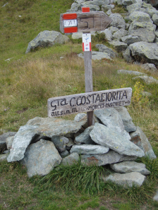 Higher up, you arrive at the Bivacco Gino Gandolfo (GPS2504), a cabin with 6 beds and a table, but without any further provision. It appeared clean, considering the fact that it’s an unguarded and unlocked hut.
Attention: The hut is on the right side of the path. From the hut, you have to return in your steps and go to the right to find the markings of the path. From here you slowly climb to the Colle Paschiet (GPS2505) (3h00′).
After the Col, there is a smooth descent to a bowl at the bottom of the pass (GPS2506) (15′). You’ll find a signpost there. In the bowl follow the painted arrows diagonally to the right towards the beginning of the climb (GPS2507) to the next pass, being the Colle Costa Fiorita (GPS2508). Also here you can call the path a direttissima, going straight up. After 20′ you are on top of the Colle Costa Fiorita (GPS2508). On the Col, it is best to extend your hiking poles by 20cm because at first it descends moderately, but then steeply downhill to a saddle visible from the Col (Photo Rother guide page 130). Here you will find a signpost to the left. From here on, an unpleasant descent follows until you find a good path again in a stretch of real forest!!
The descent is difficult because of the slope in combination with the long grass. In dry weather this is difficult, in wet weather it is potentially dangerous. Especially in the brook-beds, you need to be extra alert for slippery stones. Good footwear is absolutely essential here. After passing the river, you will end up in a flank with lush vegetation (weeds) in combination with moist soil (mud). The second riverbed is of an almost identical level of difficulty. You’re happy when you finally find a pleasant path under the tree line again. When you look back up, you admire the steep and hilly terrain that lays behind you and you comfort yourself with the thought that all in all it was not too bad. The conifers turn into deciduous trees. At the end of the zigzag descent, you arrive at the riverbed, which you follow until the beginning of the confinement walls of the riverbed. First, you walk a bit on this wall, then within it.
At an opening in the wall, go to the left through the opening and then take the descending road parallel to the wall, until you reach the asphalt (GPS2509) (2h00′). If you want to go to the Rifugio Vulpot on foot here, you should change to lighter footwear. You can also call the Rifugio Vulpot (see below) and they will pick you up in Usseglio. I raised my thumb and got a lift to Margone (about 30 to 45′). From there I walked over the asphalt to the Rifugio Vulpot (1h00′). The asphalt is pretty quiet, so you don’t have to fear dense traffic. The path proposed by Rother is much longer and you also have to overcome more height difference. The path through the valley isn’t longer, but you have to bridge more height differences. Especially in the second part, you have to descend from the road. On the other side of the river, you have to climb to the dam, from where you have to go through the riverbed again, to return to the road. Moreover, the path is situated in the neighborhood of the electricity line, which does not provide the most beautiful scenery. At the dam, the road makes a turn to the right, to descend to the Rifugio Vulpot (GPS2600AB), at the end of the asphalt. The Rifugio Vulpot is not really a hut, but rather a mountain hotel.
Rifugio Vulpot (GPS2600AB): 

Tel: +39/0123/83771
+39/320/8407078
Open: mid-June to mid-September.
Half-board in a room: 58€ (2024)
1/2L Red wine: 6€
Second tea at breakfast: 1,30€
Dinner (19.30h):
1°: Anti-paste
2°: 2 kinds of meat, cauliflower, polenta and salad
3°: 3 kinds of cake
Breakfast: from 7.30 am (typical Italian breakfast)
Breakfast with bread, toast, jam, coffee or tea
Room with 1 single and 1 double bed (only) (sheets, blankets, and possible duvets: old as the owners), private shower and toilet (suitable for disabled, completely new, but located on the first floor, without elevator?!!).
Day 26 Rifugio Vulpot – Rifugio Truc (dir) 14.0km 816m 910m 4u45′
Walking time without rest: 4h45′, with rest: 5h00′
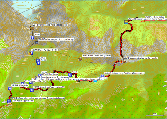
Vulpot – Il Trucco (red)
Vulpot – Cà d’Asti – Rocciamelone – Il Trucco (fine black line)
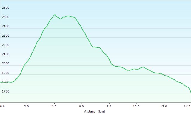
Altitude profile Vulpot – Il Trucco
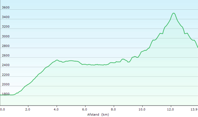
Altitude profile Vulpot – Cà d’Asti – Rocciamelone – Cà d’Asti
 The weather conditions on this day were not very favorable: cold, rainy weather with lots of wind. And so I didn’t consider a climb to the Cà d’Asti and the Rocciamelone. In favorable weather conditions, the direct ascent is an absolute must. Eventually, I got there the next day via a detour.You leave the Rifugio Vulpot (GPS2600AB) and walk along the left bank of the lake, to round it in a counter-clockwise direction.
You walk up to the tube bridge over the supply river of the reservoir. You cross it and then walk back towards the lake. Above a farmhouse at the lake, you will start the real climb to the Colle Croce di Ferro (GPS2602AB).
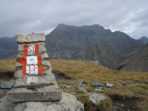 The path is well marked and causes few problems. On the pass, however, you will search in vain for a cross… a masonry stone column is all there is to find. From the pass you descend straight down, to reach the almost horizontal path to the Capanna Soziale Aurelio Ravetto (GPS2603AB). This hut is only open from mid-July to the end of August, and that’s not much use.
Because of the weather conditions, I immediately continued on the almost horizontal path that is clearly visible in the flank. In clear weather, you have a beautiful view of the valley of Susa from the pass and during the entire trip. You walk up to a pass on the ridge of the Monte Palon. Shortly after this pass, you’ll find the junction between the path to the Rifugio Cà d’Asti and Il Truc. The path to Cà d’Asti is much less ingrained in the landscape than the path to Il Truc. Considering the already mentioned less favorable weather conditions, I descended further to Il Truc.
First, you descend in a zigzag. This is followed by a descending traverse up to a stable with a signpost (GPS2606A). You won’t find any indication of the GTA here. You follow the road, which first goes to the left, and then makes a turn to the right and passes underneath the stable to end up on the road, which you can see from afar in the flank of the bowl. Along the way, you pass a signpost at the beginning of a path to the valley. Ignore this and follow the little arrow with “GTA” and stay on the road. You round the bowl and on the other side, the road rises slightly in the direction of a saddle. Once you get to the top, you’ll see a very large stable here. You keep on following the gravel road, which descends slightly. You come to an intersection with a gravel road to the left. You also ignore this exit and continue on the same road until you reach the edge of the forest. Here you leave the gravel road to the left (GPS2607A) for a forest road, which is clearly not used by motorized traffic. The branches of the trees on both sides of the road hang quite low. Further on you’ll notice that what was originally a moat on your left turns into a kind of water gutter (Il Truc). You descend further and pass under a farm.
At the next farm/holiday home, you take the most downhill forest road (GPS2619AB). In a second bend to the left, situated in a more open part of the forest, you cross Il Truc and leave the forest road via a somewhat vaguely marked path to the left towards Posto Tappa Il Truc (GPS2700).
Rifugio Truc (GPS2700):
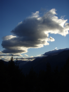
Tel: +39/0122/32963
Katerina Giorsa speaks German well.
Open: early June to mid-September (not late September as mentioned in Rother).
Half-board in a dormitory room: 55€ (2024)
Carafe: 3/4L Red wine: 6€
Bottle: 3/4L Red wine: 8€
Pasta in the afternoon first day: 5€
Dinner (19.30h):
1°: Anti-paste (much)
2°: Pasta (much)
3°: Day 1: salad with vegetables,
Day 2: Osse Bucco with tomatoes
4°: dessert
Breakfast: from 7.30 am (typical Italian breakfast) Breakfast with bread, jam, honey, coffee or tea
3 Rooms of which 1 with double bed, 1 with 2 bunk beds, 1 with 3 bunk beds, further accommodation in a holiday home with 1 double bed, 1 bunk bed and 1 single bed (common bathroom).
Dag 27 Il Truc – Rocciamelone (H/T) 13.9km +1333m -1832m 6u00′
Walking time without rest: 6h00′
Map: see day 26
After a stormy night, the sky was wiped clean. There is still a northern wind, but fortunately, that climb is on the south side of the Rocciamelone. Katerina Giorsa will take guests up by car to the parking lot just below the Rifugio Riposa 2205m (GPS2614BB). That shortens the climb by about 500m, but it still leaves 1333m.
Rifugio Riposa:
Tel: +39 0122 675173
+39 3474717113
rifugio.lariposa22@gmail.com
The smallest model Lancia loaded with 5 people and some daypacks, has a hard time on the not so smooth gravel road. We are dropped off at the beginning of the path (GPS2615B) to the Rocciamelone. Just below us (GPS2616B), the material cable car leaves for the Cà d’Asti. So we know where our first stop is. First, the path climbs almost parallel to the gravel road towards the Rifugio Riposa (GPS2614BB). Then it goes straight up. Consecutively it rises in a few zigzags. The markings try to lead you along the official path as much as possible, but an Italian who sees a direttissima…
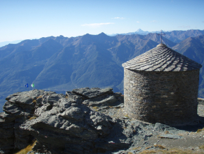 On the way up, you will see only one official direttissima. You come across a junction (GPS2613B) with an arrow ‘Short’ to the left and a ‘Long’ straight ahead. I went to the leftJ, and that went without a hitch. Both paths meet again (GPS2612B) just below the final climb to the Cà d’Asti. The first thing you see is two flapping flags. Then you see the chapel. You only see the Cà d’Asti itself at the last minute. This has to do with the location of the Cà d’Asti on the one hand, but also with the color of the building on the other hand, which makes it blend in with the landscape completely. Just below the hut, the direct path from the Rifugio Vulpot (GPS2606B) meets the path from or to Il Trucco. After exactly 1h30′ you arrive at the hut (GPS2607B).
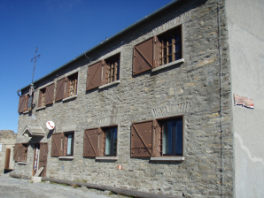 Just put your heads inside the hut, to report your presence, and then you immediately move on. If you want to eat after your return from the Rocciamelone, please report it. The first part of the path to the Rocciamelone, is clearly visible in the mountainside. However, please note that the real top of the Rocciamelone is not visible from the hut. What you see is a front top. When you go to the right of the path at the end of the first straight leg (GPS2608B), you can see the real top.
Up to the front, recognizable by the high stone column with a cross (GPS2609B), the path itself does not involve any difficulty. But it’s getting more and more breath-taking, especially if you haven’t been here around for four weeks. From the column, the path goes in a kind of ledge, diagonally in the flank. In this ledge, there is a lot of snow. In mid-September, the quantity was not annoying. You could easily get around it. But don’t count on the snow to be soft. At the beginning of the summer, it may be advisable to bring crampons. After the long passage in the ledge, you go to the left and you’ll see the first ropes.
Also notice the icicles on this first rope, which actually hangs on a kind of pass under the top. These are mainly installed in view of the powerful wind field that can manifest itself here. Just above the top quite often, you will find cirrus clouds.
 When you really want to stand on the top, at the orientation table, and the wind comes from the north, it’s as if you pull open the door of a fast cooling system. First of all, you have to make sure you don’t get blown over. Then you throw your backpack down in search of your gloves because your hands will feel as if you’ve put them in liquid nitrogen. After having taken the necessary pictures on a trot, you plunge back into the lee of the southern slope at the Bivacco Santa Maria. The Madonna del Neve (snow)… she didn’t steal her name. Luckily they have been kind enough to turn her back to the north so that she looks down on Susa with kindness. Behind her back is only a glacier. In Austria, they often solve this problem by hanging a Christ on both sides of the cross, so that Christ would not seem to turn his back on the other valley… (the sensitivities of symbolism :-)).
In case of emergency, the Bivacco Santa Maria is always open, but apart from a cabin with 14 beds, there is absolutely nothing here… not even water. There is a (dry) toilet in the flank under the hut, indicated with an arrow. However, the chapel is only open on public holidays.
After a short break, you start the descent. It’s better to take a longer break at the stone pillar with a cross on the front top because that was the first place where it was somewhat pleasant (out of the wind). But after 10′, you’ll probably continue the descent to the Cà d’Asti (1h15′)
Cà d’Ast:
- Proprietor: Parrocchia S. Giusto Susa Tel.0122-622053 (NON-CAI)
- Beds: 60 summer – winter room
- Open: July tot half-September
- Tel Rifugio: +39/0122/33192 (only during hut opening)
- Tel propietor: +39/011/9632015 (Fulgido Tabone)
- rifugiocadasti@libero.it
Meal: spaghetti from a plastic plate with plastic cutlery (7€) and a glass of red wine from a plastic cup (1€, 8€/L, not super) (Half-board: 27€ given the food probably not a big luxury).
As said before, there is no potable water here, and therefore no water for washing dishes. That’s why everything here is disposable. The drinking water is supplied from the valley by means of the material cable car. After enjoying the sun and the view outside, at the front of the Cà d’Asti, you descend to the parking lot (1h00′).
From here, the Rother tracklog leads you down via cattle tracks, thus cutting off the hairpin bends from the road. That is so difficult that descending by road seems to me to be a better option. From the intersection GPS2617B, you can see a farm on your right. Turn right and descend in that direction to a farm/holiday home (GPS2618AB) at a crossroads underneath this farm. From here you descend via a marked forest road until you find in the second bend to the right a signpost (GPS2619AB) to the left in the direction of Posto Tappa Il Truc (GPS2700) (45′).
Rifugio Truc (GPS2700):
For all other information, see the above.
Day 28 Il Truc – Meana di Susa 10.5km +162m -1335m 3u15′
Walking time without rest: 3h15′
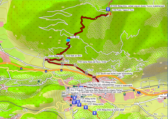
Il Trucco – Susa (dikke rode lijn)
Susa – Meana di Susa (fijne rode lijn)

Hoogteprofiel Cà d’Asti – Il Trucco (1705m) – Susa
According to Katerina Giorsa (situation 2012, future?), path 558 (direct descent to Susa) is blocked in many places by fallen trees. Asking for the status of this path is therefore advisable. You descend therefore along the normal GTA path.
You descend the gravel road in a westerly direction. In the first curb, you will find markings of the GTA. You cut off a couple of hairpin-bends off the road. At a certain moment, you see on your left a signpost to the Rocciamelone and Cà d’Asti. I suppose this is where you’ll find the beginning of path 558. I didn’t immediately see white/remarkings or signposts to the valley.
The only good markings you’ll find are those of the GTA and so you follow these and descend into the valley without any problems. Here too, you’ll need to watch out for small pine cones on the path, which work like bearing balls or Rolling Stones under the soles of your shoes. The deeper you descend, the more you are confronted with the noise of the motorway in the valley. The plinths of electricity pylons also point out the characteristics of our modern society, which are squeezed together once again in a mountainous landscape and are therefore strengthened in the valleys.
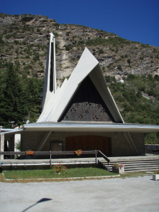 At the church of the hamlet of Marzano (GPS2702) ends the GTA marking. You descend via the asphalt towards San Giuseppe (GPS2703), where you arrive at the slightly wider SP209. Here you go to the left and walk parallel to the highway, which is enclosed by sound walls. Along the way, you will pass 2 restaurants and a modern church with the same statue of the Virgin as on the top of the Rocciamelone as the spire on the church tower. After the second restaurant (GPS2706), turn right (GPS2707) under the highway. At the end of this road (GPS2708) you turn right towards the center. You cross a canalized stream and walk to the parking lot next to the station. Here you turn left (GPS2709) until you reach the station building.
Susa Station: The station in Susa is a terminal (GPS2710). So you can only leave here in the direction of Torino. If you want to travel back to France, you should either take the train here to the first station that is not on the end track of Susa, namely Bussoleno. Here you can also take the train to Bardonecchia. You can buy a ticket to Bussoleno or Torino in the bar of the station of Susa.
For those who have some extra time, there is another possibility to continue walking towards Meana di Susa. This station is located directly on the aforementioned international railway line Italy – France. This is where the Torino – Bardonnechia train stops. The advantage of this option is that you can quietly visit the town of Susa and that you can stay overnight in the Posto Tappa of Meana si Susa, Albergo Bellavista.
For the continuation of the GTA towards Meana di Susa, turn right at the station of Susa. In the park there you will find a water tap (GPS2711), where you can replenish your water supply. At the first traffic lights (GPS2712), cross the road and walk towards the bridge (GPS2713) over the river Dora Riparia. Cross the bridge and walk in the same direction until the road makes a slight turn to the left. You will find a pharmacy on your right (GPS2715). If you are in a hurry, walk straight ahead in the direction of GPS2723.
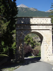 If you have a little more time, turn right here. Halfway down the street, you’ll find Pizzeria Ristorante Italia (The best pizza in Susa according to Rother) (GPS2716). At the end of the street, you will find a grocery store (GPS2717). Here you turn right at the cathedral of San Giusto (GPS2718) and the Porta Savoia (GPS2719). You continue straight ahead, slightly uphill. The road makes a 90° turn around a park. Higher up, you will first find the Arch of August (GPS2720) and shortly after that the remains of an aqueduct (GPS2722). Between them, you will find the entrance to the castle (GPS2721). After the aqueduct turn left and descend back to the main street (GPS2723). Here you turn right towards an intersection with the SS 24. Take the zebra crossing on the left side of the street and cross the SS24. Here (GPS2724) you turn left into a small street (Via Colle Delle Finestre). From here on, you’ll find signs for the GTA and a sign for the Alpe Toglie and Meana di Susa ’30’. The street makes a bend to the right (GPS2725) and at the end of it a bend to the left (GPS2726) before leaving the boundaries of Susa for a mule track, that goes up through the forest. You pass some kind of gate building, where you take your way to the right of it. This leads to a short stretch of asphalt on private property (GPS2728). Here you go left up. The asphalt becomes a gravel road again. This is followed by a descent and another climb to an intersection with signposts (GPS2729). Here you turn left into Via Pian Barale. Opposite the access road to the station (GPS2731) you will find the Albergo Bellavista (GPS2730).
Albergo Bellavista (GPS2730):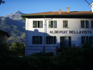

Tel: +39/0122/39162
Open: All year round, but how much longer if you see the age of the current owner?
Half-board in a room: 44€
1/2L Red wine: 4€
Dinner (19.30h):
1°: Anti-paste (much)
2°: Pasta (good)
3°: Meat with mashed potatoes
4°: dessert or fruit
Breakfast: from 7.30 am (larger Italian breakfast) Breakfast with bread, 2 croissants, cornflakes, jam, honey, fruit juice, coffee or tea
Room 1 on the third floor with 2 single beds, private bathroom in the room. Problems with the overall cleanliness of the room. The owner has already passed the age of 70. Noise from passing trains, which run approximately at the height of the third floor, despite the location of the room on the other side of the hotel. Nice view of the Rocciamelone.
Price conscious alternatives (2024):
Half time conclusions for those who break up their hike in Susa:
After 4 weeks my vacation for the current year is over and I have to return home. My condition is optimal. I’ve had almost no physical trouble and only a small blister from the day that I combined 2 stages because of the closure of the Albergo degli Amici in San Lorenzo. I’ve conquered some 33,000 altimeters. From my conversation with a park ranger, I learned that the 2 rainy days I had to endure, were the only 2 rainy days since August. Because I partly anticipated weather changes and also had a dose of luck, I didn’t have to deviate from the planned route because of the weather conditions.
I recommend the use of GPS in Italy because you can never be sure of the quality of the markings and signposts on the terrain. It is not absolutely necessary, but it does save time, energy and frustration. I’m old enough to be able to do without it, but the technology exists, so I don’t see why you shouldn’t use it. I’m not constantly looking at my GPS. I only use it if the markings on the terrain are insufficient.
In addition to self-knowledge, this trip requires a wealth of skills, mainly walking technique on all types of terrain, including stone plates, loose gravel and to a limited extent: snow. A little elementary climbing technique doesn’t hurt either. In addition, you must have basic knowledge of meteorology and be flexible in your plans. Adjust your travel plans according to the weather, your physical condition, and your skills. Self-overestimation leads to accidents. Go into the mountains, but come back (alive!).
Coördinatenlijst (2019):


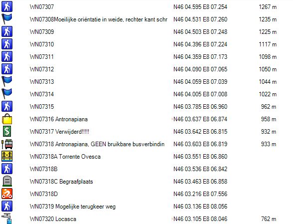
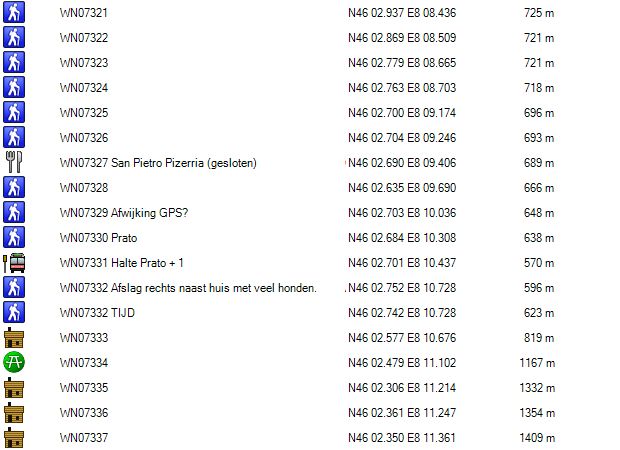
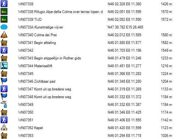

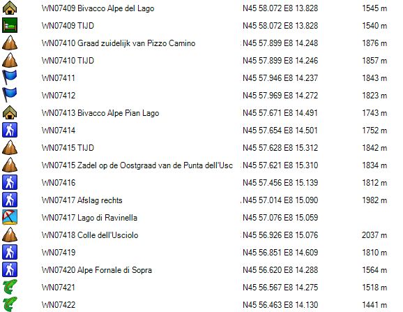
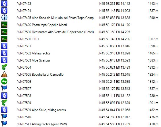

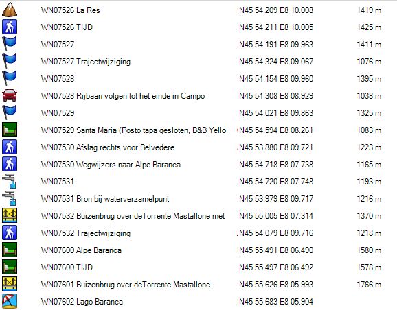
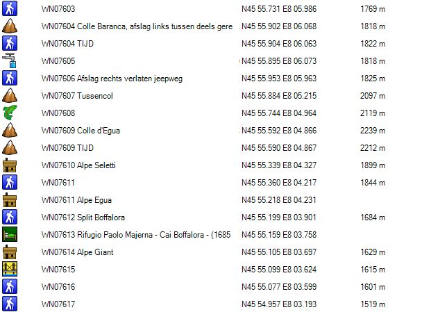


/Cima%20Verosso/Tanti%20laghi.jpg)
/Cima%20Verosso/Grossi%20blocchi.jpg)
/Cima%20Verosso/Lago%20di%20Oriaccia.jpg)