
Travelogue GTA South – GrandeTraversata delle Alpi
Great Crossings of the Alps (Susa – Ventimiglia).

Countries: Italy, sometimes literally on the border with France
Region: Piedmont
Route: Susa – Ventimiglia (Italy)
Period: 26/08/12 to 16/09/12 (Updated 2024)
Travel company: solo
Public transport:
Outward trip:
- Each Belgian Railway station – Brussels-South (Midi)
- Brussel-South (Midi) – Paris (Gare du Nord)
- Paris (Gare du Nord – Gare de Lyon RER D (2 stops, approx.10’)
- Paris (Gare de Lyon – direction Milano until Oulx)
- Oulx – Meana di Susa (direction Torino, 1 to 2 trains each hour)
Return trip:
- Ventimiglia – Menton (at least 10 minutes of queuing at the ticket counter, because cross-border tickets are not available at the vending machine.)
- Menton – Nice Ville
- Nice Ville – Brussels-Midi (a TGV with a delay of more than 25′, which runs via Lille instead of splitting in Paris Charles de Gaulle and then driving directly to Brussels).
- Brussels-Midi – each Belgian Railway station
Lodging:
- Cabins owned by the CAI (Club Alpino Italiano) (56€ (2024) Half-board on a dormitory, as a member of a mountain sports association).
- Posto tappa to Hotels elsewhere from 40 to 100€ in a room or on a dormitory with half-board.
- Exception: Arrucador/B&B L’Abric: >100€ HP (2024) Half-board without any extra charge (luxurious, but not very transparent in their billing). They are clearly used to customers here, who do not look at the bill but just pay
- One cabin mentioned that their water does not meet government standards to be classified as drinking water. In the kitchen of the hut additional filters were placed and you can ask for your drinking water for the next day there.
- The unmanned hut Rifugio San Remo only has rainwater, which you have to boil at least 10′ before use. As the stages of the day are not too long, I arrived with the 1.5L normal drinking water of the previous day.
Payment method:
- Cash
- ATM (Attention: only available in the slightly larger places in the valleys, see travel report)
- Visa (Attention, difficult acceptance, given the small amounts.)
- Cash collection with Visa expensive!
Travel literature:
A recent (2013) and extensive edition now exists at Rother: GTA Grande Traversata delle Alpi (with GPS coordinates and a tracklog for the entire main route.) In my opinion the best and most detailed guide at the moment. No risk of getting lost. In view of the varying quality of the markings on the terrain, this is sometimes not a superfluous luxury for those who are reluctant to drive extra kilometers.
Note: only the parts in purple indicated on the maps are personal tracklog recordings. These are usually the variants indicated in the guide that I explored. Between Pontbernardo and Strepeis this is mainly a large shortcut since the choice of route by both Rother and the GTA seems illogical to me. Only these recordings can be obtained from me. For the Tracklog of the main route, I refer explicitly to the Rother guide and website.
Survey maps:
Only the maps drawn in the guide and the digital relief maps in the Garmin GPSMAP device. Additional digital maps uploaded from www.freizeitkarte-osm.de using (Garmin) Mapsource.
Internet:
www.klingenfuss.org/gta_nord.htm
www.ratp.fr (metro Paris)
www.tilo.ch or www.trenord.it (Connection Milan – Airolo)
Personal data:
Great Crossings of the Alps
(Susa -Ventimiglia).
Introduction:
Whereas München – Venetië is a trip of 3 weeks alpine and 1 week “flat” terrain, with a total height difference of approx. 25,000 meters and the E5 Oberstdorf -Verona is clocked at approx. 21,000 meters, for the southern part of the GTA (Susa-Ventimiglia) as described in this report you have to overcome 30,000 meters, and that in 3.5 weeks. In short, this means more than 1,000 altimeters up and down per day and that for 23 days at a time. Those planning to walk the whole stretch, have to add the 4 weeks and 33.000 meters of the GTA-North.
That’s a lot. That’s is huge. And so it is important to know the limits of your body and especially not to exceed them. It is therefore important, not only to keep your own body weight low but also to limit your backpack weight as much as possible. Know your material well: good shoes and especially a pair of hiking poles are indispensable.
GTA (North), seven years later:
Whereas in 2012 I was mainly alone on the GTA and therefore also mainly slept alone, this was completely different in 2019. In 2019 my travel companions were Germans and German-speaking Swiss men and couples between the ages of 60 and 70.
Apparently, these people can no longer correctly assess their own physical abilities. The result is that they needed 2 to 3 hours additional time than what is indicated in the guide for that day trip of about 6 hours. An additional problem is that the legs further on the GTA sometimes surpass 8 hours, and if you add then another 3 hours or more, there is a danger that you will endanger yourself as a mountain hiker.
From the reactions of these travel companions, I also understood that they have greatly underestimated the physical difficulty of the GTA. I myself don’t see myself hiking any more along the GTA once I have reached that age group. I may be able to handle it physically, but will I still like it, or want to do it? I think the odds are slim. I can already see that my pace is slowing down, especially on very hot days. And given that these will increase with global warming…
Especially the E5 Oberstdorf-Verona (Dutch version only), as well as Munich-Venice, seem to me to be more pleasant alternatives, as the number of accommodation points is higher and you can choose your own pace better so that with the increase of the years it still remains a holiday.
For family reasons, I had to travel earlier than usual in 2019. As a rule, departing early means more problems with snow residues. From a conversation with the locals I learned that May 2019 was exceptionally cold in the region concerned, so there was still a lot of old snow in the higher regions of the GTA and surroundings.
The return visit to the GTA is part of my project Vienna – Nice. My original plan was to reach the GTA at the Rifugio Margaroli. However, this meant that I would have to go above 2600m for several days. Given the snow load, I was advised not to do this, and I also followed that advice.
Of course, I had already set out an alternative route at home, which remained a bit lower in altitude, and was, therefore, more snow-free. My fellow mountain hikers in the age category 60 to 70 years, showed the traces of the of injuries sustained during slidings in the snow, because they stuck to their original plan to walk the GTA from its normal starting point, as described in the Rother guide, being the Alpe di Cruina, resulting in the fact that during the first two to three days at least 2 passes above 2600m have to be conquered.
Flexibility in planning and knowledge of one’s own limitations and skills are once again of the utmost importance when it comes to planning and executing mountain tours, especially when they take place early in the season. Go into the mountains, but come back (alive!)
GTA & the Tiger Mosquito:
Especially on my last real high altitude day in 2019, being between the Rifugio Coda and Trovinasse, mosquitoes were to be found at an altitude above 2000m, which was never experienced before. And it really wasn’t about a lost specimen. They were numerous enough and above all much more aggressive than what we are used to from our local “house mosquitoes”. You can rather compare them to Scandinavian mosquitoes, for those who have experience with them. Only these specimens can transmit tropical diseases. That’s why the people at the Red Cross are afraid of its impact on blood safety. For the Red Cross, there must be one month between the end of the journey and the blood donation for destinations in northern Italy and in particular cities in and around the Po Valley.
And so it is better to bring along a DEET spray of at least 30% active ingredient, especially for the parts of the GTA around the Po plain. Such products are available from the brand Care Plus, available in the better outdoor sports shop. But also at Decathlon, there is already a “Private label” product available, which is sufficiently strong.
Physical preparation:
The better your physical condition at departure, the greater the chance that you will be able to enjoy your trip. Maybe it has something to do with the increasing number of years, but I am becoming more and more convinced of the need for good physical preparation.
Walking in midrange mountains is good, but the feeling of a climb of 2500m in combination with a descent of another 1000m is hard to match. Find yourself a challenge in a nearby mountain group, where you’ll come as close as possible to the normal mountain trail stages in terms of meters of ascent and descent. Start with smaller stages if possible in terms of accommodation. If you live near sea-level, your body needs at least 3 days to get used to sleeping above 2000m.
It is wise to bring your BMI below 25, as you not only have to carry every kilo of equipment but also every kilo of excess body weight.
Equipment and nutrition:
Clothing on the body:
- Shoes: For longer tours with a reasonable amount of technical difficulty, I nowadays usually use a combination of 2 shoes, namely:
- A pair of approach shoes type A (The North Face Hedgehog)
- A pair of type C mountain boots (La Sportiva Trango Alp Evo GTX – Löwa Alpine Evo GTX of Cadin II GTX Mid) with a climbing type sole. It has very good contact properties on wet stones, but it does wear out quickly, making it quite expensive to use. Generally speaking is the level of difficulty lower in the southern part than in the northern part. Therefore a less technical shoe like the Lowa Renegade Mid A/B can be considered, when there is a low chance of having to use crampons or an ice axe.
- Set of socks: preferably 2 of good quality (loop fabrics on the inside and ranging in materials from wool to Coolmax)
- Summer climbing pants (Mammut Schoeller Dryskin) or a cheaper alternative from Decathlon.
- Synthetic underwear: briefs (my preference goes to the microfiber ones by Nur Die) and T-shirt with long or short sleeves (for sale at Decathlon or the classic outdoor sports shops)
- Lightweight fleece
- Sun hat (Decathlon)
Clothes in your backpack:
- Gore-Tex jacket with hood or rain hat (Outdoor Research). (Gore-Tex still enjoys my preference, but those who are deterred by the high purchase price, may find reasonable alternatives at the Decathlon store)
- Sunglasses with high filtration rate, sunscreen (SPF 20 or higher) and possibly lip balm with sun protection)
- Replacement synthetic T-shirt and slip
- Set of spare socks
- Set of spare clothing (shorts with your spare T-shirt) to wear in the cabin and cabin slippers. In most lodges you can’t enter in your hiking boots, but the floor isn’t sufficiently even, to just walk around wearing only socks.
Other equipment:
- Telescopic walking poles (relieves the pressure on the knees, when descending). It is advisable to buy poles of well known brands: Leki or Decathlon, as a cheaper alternative. Even cheaper are Naturehike poles bought on AliExpress. Pay attention to the material of the handles (no hard plastic) and eschew particularly sticks with a buckle in the hand strap. Prolonged use will irritate your hands at the buckle.
Backpack of 45+10l.van Lowe Alpine, which is lighter than my previous model from Decathlon. Despite the fact that the backpack comes with a rain cover, I always put everything in plastic bags closed with a metal clip. Small gear and daily rations go into freezer bags from Aldi. - Silk sleeping bag liner (Sea to Summit)
- Cabin type sleeping bag 10° (Decathlon, used twice, as I had it with me anyway, but I wouldn’t drag it with me a second time :-)).
- 1 towel 50 x 30 cm, preferably in micro fiber (dries faster and carries less odor, when not dried properly.)
- 1 small bottle with a shower soap and shampoo, a washcloth, a small travel toothbrush with toothpaste (you can also save an almost empty tube for travel), a stick of shaving soap and disposable razor blades or an electric travel shaver on batteries.
- A few packets of paper handkerchiefs, does double duty as toilet paper.
- A Camelbak preferably with a total capacity of 2 to 3 liters (see trip descriptions for sources along the way.) Don’t know whether I like the new models with the zipper closure.
- Opinel knife or Swiss Army knife
- Micro Headlamp (Petzl Tikka Plus 2) to find your way back to your tent in the dark.
- Personal pharmacy: bandages, sterile gauze, antiseptic, wound plasters, scissors, sports tape, Compeed, ibuprofen, paracetamol, Rinomar (for runny nose) Immodium (generic: Loperamide for diarrhea).
- Spare plastic bags
- Needle and thread
- GSM (network coverage not assured) or GPS with combined satellite phone for those who can or are willing to pay for it.
- Orientation aids: GR 20 guide with topographical maps (see above), compass and / or GPS
- Mosquito product (Care Plus)
Nutrition:
According to nutritional guidelines, your diet should contain a ratio of 15% protein, 30% fat and 55% carbohydrates. For some sports, you can even use up to 70% carbohydrates. However, take into account the fact that fat contains more calories for the same weight of food. For this trip, I only brought some reserve from home for the first few days. In practice, this is up to Ghigo di Prali (4 days). Finding decent supplies is a relatively big problem here, as the village shops sometimes have a very limited range. So you will have to be satisfied with that what’s available. A good strategy is to limit yourself to chocolate and cookies, and when you arrive early, you can have pasta for lunch at the cabin, hotel or Posto Tappa.
A menu must be sufficiently varied and must, of course, be acceptable to you.
Many sports foods already state their composition. If you don’t find it on the packaging, you will have to use a list with the nutritional composition of different sorts of food. These can be found in a book on dietetics in the library or on the Internet. If you know that 1gr of proteins corresponds to 17 kJ or 4kcal, 1gr of fat to 38 kJ or 9 kcal and 1gr of carbohydrates to 17 kJ or 4 kcal, then you can do it yourself.
| Naam: | Gr.: | Proteins: | Carbohydrates: | Fat: | KJ: |
| Muesli bar Aldi | 75 | 5,2% | 52,20% | 9,00% | 1313,25 |
| Energy Bar | 80 | 3,9% | 56,72% | 7,52% | 1308,08 |
| Chocolate nuts | 120 | 9,84% | 41,72% | 13,57% | 1374,65 |
| Snickers (Foré) | 60 | 5,7% | 34,80% | 15,00% | 1243,20 |
| Total: | 335 | 7,39% | 56,75% | 13,60% | 5239,18 |
The chocolate is usually from Ritter Sport. Alternatives can be found also at Lidl or Aldi.
Energy Bars can be found at Aldi of Lidl. Foré (fake Snickers) can be found at Aldi. Buy hard muesli bars, not the soft variety, because they crumble easily when being stored in your backpack. Otherwise, you need to keep them in a box which adds extra weight.
Italian cuisine and eating habits:
In a low carbohydrate diet, carbohydrates (bread, pasta rice, potatoes) should preferably be replaced as much as possible by higher-quality foods such as vegetables, fruit, and nuts. And let the Italian and Piedmontese cuisine be principally based on refined carbohydrates like bread, pasta, and polenta. Good for sportsmen, but very bad for those who aren’t. Polenta tastes absolutely like nothing, even if it is prepared in a copper kettle over a wood fire. It is an unattractive porridge that only gets its taste from what is added. The production of handmade pasta is very labor-intensive, but the difference in taste is too small in relation to the energy invested. And if you sometimes eat pasta twice a day, you’ll get tired of it anyway. The lack of unprocessed fruit and vegetables only reinforces this feeling of culinary poverty. Canned pasta, polenta, and tomato concentrate have a longer shelf life and are easier to transport than fresh products. However, most of the accommodation points are on the tarmac, so this is not really an excuse.
In addition, the timing of carbohydrate intake is also very bad here. The main meal is enjoyed in the evening before going to bed with an excess of calories, while the Italian breakfast is notoriously frugal. Very often the bread is the surplus of what you got at the main meal in the evening and therefore dry. In addition, the supplement is limited to sweet. Cheese or meat are real exceptions. Sometimes you get muesli or brown bread. So you have to systematically ask for bread.
Booking of cabins, hotels and posto tappas:
For this trip, I did not book a single night from home. That was a good thing because during the first five days I was one day behind and from day 20 on, I was one day ahead of my planned schedule. All this happened through no fault of my own. In most of the places where I stayed overnight, I asked to call the next place to announce my arrival and the arrival of my possible fellow travelers. This is good for all parties involved. In this way, they can prepare for the arrival of the right number of guests. For the sake of completeness, I will provide the phone numbers found on the internet. Know that in reality, it is sometimes difficult to reach GSM numbers in particular, as we have to establish an international connection.
Outward journey:
Where you can easily book a plane a year in advance, this is still not possible with a TGV. 3 months in advance is usually the maximum. How people still don’t realize, that this is a handicap is still a mystery to me. Moreover, environmentally conscious travel by train is often more expensive than by plane (depending on the destination). A TGV is often referred to as TGV, but in practice, this is often not the case, either because there are too many stops, or because the tracks have not been adapted. Moreover, there is still the problem of Paris, a city without a north-south connection for trains. And if you ever take a train that goes around Paris, they’ll make it stop in Lille on its way to Brussels South, where that train was announced as two trains at the time of its departure in Nice (Lille Europe – Brussels South). Splitting the train in Charles De Gaulle is probably too logical, or the Belgian conductors will be obliged to work on French territory for too long…
However, that year for the first time I managed to buy a ticket for both outward and return journeys at an acceptable price. Most of Milan’s airports are far away from Milan and flying directly to Turin is expensive. Moreover, the tickets for Flixbus have become considerably more expensive lately, making the train suddenly attractive.
In 2024 Ryanair flies from Charleroi (Brussels South) to Torino at competitive prices, which makes it a very attractive option! (Fast, cheap, but less ecological).
You can take a TGV to Paris North. In Paris, you dive into the subway and follow the indications RER D. At one of the vending machines you buy a single ticket (Taking Euro coins along is handy) Then you look out for the Line 44 and the Garde de Lyon which is announced well. 2 stops and 10′ later you leave the metro and follow again the indications Grandes Lignes and Garde de Lyon. In the station itself, the correct tracks for the respective destinations are announced late. If you are also unlucky enough to be in coach 1 of a train with 16 carriages, it is useful not to have too much luggage with you ;-). Until Lyon, the train runs at TGV speed, but after that, it becomes a very normal train in terms of speed. In the Vanoise, the carriages destined for Annecy are disconnected. In Modane, customs come on board. In Turin, the train stops at the wrong station and you have to return. So it’s better to get off at Oulx and change to the local line that stops at Meana di Susa and Torino Porta Nuova. Despite its name, this appears to be the old terminus and not the station where the international trains stop.
Don’t forget to bring cash for the first few days when you leave Meana di Susa, as there are only ATM’s in Susa itself.
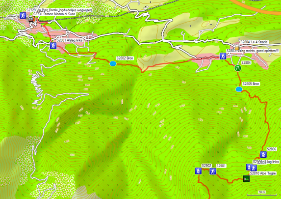
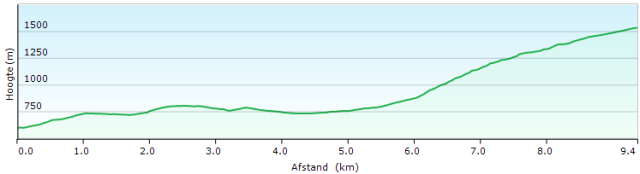
Day 28: Meana di Susa – Alpe Toglie 9.4km +1150 -117
Albergo Bellavista (GPS2730) (Probably closed):
Language: Italian and French
Tel: +39/0122/39162
Via Pian Barale, 6, Torino,
Dinner (19.30h):
1°: 2 Anti-paste (much)
2°: Pasta (good)
3°: Chicken with carrot
4°: dessert, fruit or cheese.
Breakfast: from 7.00h (larger Italian breakfast) Breakfast with bread, 2 croissants, cornflakes, jam, honey, fruit juice, coffee or tea
Room on the first floor with 2 single beds, and private bathroom for 2 rooms, the second one was not occupied. Problems with the overall cleanliness of the room. The owner has already passed the age of 70. Noise from passing trains is less on the first floor than on the third, despite the location of the room at the front of the hotel.
Possible price conscious alternativs (2024):
Oasi verde Susa città, 1 Via San Saturnino, 10059 Susa, Italië(53€)
Convento Boutique Hotel, 5 Piazza San Francesco, 10059 Susa, Italië(70€ met ontbijt)
Those descending from Il Truc, can consider continuing towards Alpe Toglie.
From the Albergo Bellavista, you go to the left. At the end of the street, you go to the left under the railroad tracks, and then you go back to the left. Before the first bend in the road, you leave the road to the right via an overgrown mulattiera in the direction of Cordolla. You cross the village in a straight line and at the end, you turn left (S2801). Then it goes through Assiere towards Menolzio. After the city center, you turn left (watch out for the exit – GPS S2803). You reach the asphalt again at a picnic area, where you go down right. From here the better climbing starts J. At GPS S2806 you reach the border of the Parco Naturale Orsierra Rocciavre. You enter a more open part and there is also a split of 2 variants, which eventually come together again at GPS S2809 (signpost Alpe Toglie 10′), where you come back on a wider gravel road. Then it goes up not to the first hut, but to the slightly higher Alpe Toglie.
Walking time without rest: 3h00′ with rest: 3h00′ (first short day)
0.5L water
Posto Tappa Alpe Toglie (GPS 2810):
Language: Italian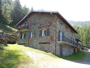
Tel: +39/338/1249716
+39/339/3980457
Open: June until the end of August!!!!! (Check by phone from your hotel in Susa!)
(Alternative: Bivacco Orsiera: well-equipped unmanned cabin, 10 beds with blankets, oven, gas fire, spring, and shower, adjacent to an alpine farm, which was unmanned at the end of August 2013. Attention: you have to bring your own food. Walking time Alpe Toglie – Bivacco Orsiera: 1h15′)
All in: (No recent tarifs on the internet)
Dinner 19:00hrs:
0°: Anti-paste
1°: Pasta
2°: Meat with tomato
3°: Cheese dish (Portions small, but all together OK)
Dinner outside unpleasant because of the noise of the engine of the milking machine that they have just hung on the terrace. (Strange choice of place!!!:-()
Breakfast 7:00: Typical Italian with only bread and homemade jam, coffee or tea.
Room: 14 beds, with blankets, a hot shower and toilet, hand soap, table chairs and a small kitchen for self-catering. Sheet-bag required.
Day 29: Alpe Toglie – Usseaux 15.2km +1327m -1432m
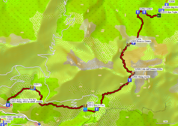
 You leave the Alpe Toglie to the left parallel to the stables. At the end of them, near the access road to the stables for the cows, go right up towards a small house. The path will remain more or less horizontal for a long time until GPS S2901. Here it goes up to GPS S2902. Here you go to the left and it goes up slowly on the ridge between Monte Benetto (1717m) and Monte Genta (1872m). From Monte Genta (1872m) the path goes horizontally to the Bivacco Orsiera (GPS S2905). You have a view over the valley here.
Well-equipped unmanned hut, 10 beds with blankets, oven, gas fireplace and shower, adjacent to an alpine farm, which was unmanned at the end of August 2013.
Please note: you must bring your own food.
Walking time: Alpe Toglie – Bivacco Orsiera: 1h15’
 After the Bivacco Orsiera, the path is vague, a phenomenon that often occurs in grazed areas. You’ll only find cairns there. Once in the real slope, the path is clear again. The path is rather marshy because of the mountain stream. In addition, the path is partially overgrown as a result of the lush vegetation. So pay close attention to the signs. Only at the end of this zone does the path turn towards the Colle dell’Orsiera 2595m (GPS S2906). Just in front of the Col, you’ll find high wooden poles, which show the way in the snow.
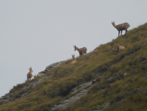 On the Col, you may find chamois near the Monte Orsiera. After the Colle dell’Orsiera it goes to the right below the ridge. The paint markings here were very good (in 2013). At GPS GPS S2908 you turn right towards Pracatinat and La Chalps. Then follows a descent in a zigzag to an altitude of about 1900m, after which the descent turns into traverse in the forest until you cross a gravel road (GPS S2909), where there was relatively much traffic on Sundays. After the road, you descend in a zigzag to Puy. In Puy, the markings follow a different route than the GPS tracklog. In front of the church, turn right. Then you descend to the river, which you cross over a bridge. Then follows a short climb through a meadow that has been eaten bald, without shade. After Puy you mainly stay at the same level. Then a stretch of forest follows. Here you’ll find a lot of wild strawberries. Further on it goes through a meadow area, where the route is indicated by plastic red poles on springy pedestals. Just before Montagne D’Usseaux, turn left in the direction of a signpost at GPS S2914. Here you will find a clearer way to the GPS points S2915 to S2917. From there, you descend again strongly to Usseaux itself. Next to the road you will find proverbs engraved in wood, made by the owner of Posto Tappa ‘Pzit Rei’. At the source in Usseaux you turn left into the street until you see the trinket shop and Posto Tappa ‘Pzit Rei’ (ring the bell) on the right side of the street.
Walking time without rest: 6h00′ with rest: 6h45′
1.5L water
Posto Tappa ‘Pzit Rei’ (GPS 2918) (Closed!):
Language: Italian, French, and English
Jamier Anna
Tel: +39 012183876
E-Mail: annajahier@alpimedia.it
Taal: Italiaans, Frans en Engels
www.pzit-rei.it (Site not accesible)
Alternative:
La Placette
by Elisa Blanc – Via della Chiesa 5 – 10060 – Usseaux (TO)
Day 30: Usseaux – Didiero 22.6km +1452m -1659m

 Leave the Posto Tappa ‘Pzit Rei’ by the back door to the breakfast kitchen and turn right. You descend the half paved road to the asphalt. Here you go to the left and descend to the main road. Follow this road to the right until you pass a bridge. A little further you will find an exit to the left in the direction of Laux. You descend on this road to a second bridge (over the main river) and then you climb towards first the Hotel Lago del Laux (Expensive!!!) and consecutively towards the hamlet Laux, which is said to have been declared the most beautiful village. Either walk to the right through the parking at the beginning of the village or walk into the village and then take the first street straight. Follow this road to a fork in the road (GPS S3003), where you take the rising road to the right.
At GPS S3004 you will find the first signs of a path. The road ends at GPS S3005, where you will find a caravan. From here it becomes a real mountain path, which climbs through the forest. At GPS S3007 you will find the first junction to an Alpine farm. At GPS S3008 you will find the junction to Lago D’Albergian. Here you go right. Then the path zigzags to the Colle dell’Albergian 2713m (GPS S3010).
In the descent, in the south flank, you will find a lot of erosion. You first pass by a stable (GPS S3011 Rifúgio Moremout). Then you descend on the left bank of the river. Leave it at the waterfall and follow a path in the flank, until you can descend again at GPS S3016 in the direction of the main river. It then follows this river to Balsiglia (Start of asphalt – GPS S3017).
Posto Tappa Balsiglia (GPS S3017)
 Contrary to what is stated in the Rother guide, it is not closed, but open. This is a self-care posto tappa, as usual in the old school building, where a MuseoValdese is located on the ground floor. You will find beds with blankets and even sheets, a gas fire, microwave, and some pots. There is no restaurant or shop in the village. When it comes to food, you have to rely on the contents of your backpack. There is a donation box, where you have to leave the requested compensation.
From Balsiglia you walk to Didiero in 1h15′. On the way, you won’t find any signs to Didiero, but you will find signs to Salza di Pinerolo, the main town to which Didiero belongs. Ghigo di Prali is also indicated. Ignore all signs that want to make you deviate from the asphalt road because they mean more climbing and descending. There’s almost no traffic on the road On the way you will pass La Foresteria di Massello, for those who like more luxury.
At the entrance of Didiero, you have on your left the town hall with behind it a pizzeria. 70m further on the right side you will find the La Foresteria di Massello HP 70€.
In 2013 there were heavy rebuilding works going on here so that the entire facade was in the scaffolding. Again, the Posto Tappa is the old school building (locked), located behind Agriturismo La Miando.
Walking time without rest: 7h30′ with rest: 8h00′
1.5L water
Posto Tappa/ Agriturismo La Miando (Didiero):
Language: Italian, French
Owner: Renata Canal Brunet
Tel: +39 0121 801018
GSM: +39 339 2763215
agriturismolamiando@gmail.com
+39/339/2763215
Open: all year round
Half-board: No recent price indication other than the price of a menu: 25€
Dinner 19:30hrs:
0°: 3x Anti-paste
1°: Pasta
2°: Meat with potatoes
3°: Dolce
(Very large portions and delicious)
Breakfast (7:30): Typical Italian: bread with only jam as a spread. Coffee or tea.
Posto tappa: 10 beds, with blankets, table, chairs, wood stove. Renovated bathroom on the mezzanine floor with toilet and hot shower. A (shaving) mirror is still missing. Attention: the unmarked switch to light the electric boiler is located next to the socket to the left of the entrance door to the bathroom!!! Get the boiler’s red light on!!!!!!! sheet-bag required.
Day 31 Didiero – Rif LagoVerde 22.2km +1934m -600m

 You leave the Agriturismo La Miando and descend to the main road. Here you go to the right and across the bridge, you go to the left (signpost). On this jeep road, you will find many crossings, almost all of which are marked with signposts. At GPS S3101 you’ll find the longest shortcut, but it’s also used by the local cattle farmer to drive his cows to the farm. This happens as usual with dogs and the trail moto. When you get back on the jeep road, the situation is a bit unclear. You see picnic tables above the road. Climb up to this picnic and then follow the ridge up towards a pylon. At the end of the meadow, you return to the forest with a clearly marked path.
You reach the Colle di Serrevecchio (GPS S3104) where you change mountain flank to descend towards the hamlet Serrevecchio. In the hamlet, you don’t descend to the road, but follow the path until you come to a signpost between the houses. Here you turn left for a short time to turn right at the next T-junction. You round a meadow and descend towards Bounous. In Bounous you can reach the asphalt. You descend via the asphalt to a crossroads in a hairpin bend. You don’t follow the main road to the left. Don’t take the asphalt to the right, but take a country road, which runs to the left of the last one. You cross a meadow through two rickety gates. Then you descend to a recent pedestrian bridge, which crosses you. On the other side, the light goes up until you come back on a paved road (GPS S3114). Here you are back on the Rother tracklog. At GPS S3115 turn right and it goes up further. You can either follow the road, or you can follow the crossings via the path. Especially at a source, the path is very vague and the signs are not very visible. The GPS will then bring relief.
Back on the road, follow it through a few hairpin bends until you see another signpost. From here the path is clearer. For a meadow, you turn right, along the fence to the next signpost. At the next junction take the horizontal path to the left. You follow this up to a jeep road, which you follow downhill to the main road in the valley. At GPS S3127 you have to turn left, along with the houses of the hamlet Cugno, to reach the asphalt. Rother’s tracklog follows the main road. You can also cross the river via a tube bridge and then on the other side via a camper parking and a picnic to reach the Ghigo di Prali.
In Ghigo di Prali you can replenish your reserves both financially and in terms of emergency food supplies. At GPS S3129 you will find a shop with a fairly wide assortment, which is also open on Sundays. It is only closed on Monday afternoons (8 – 12.30 & 16.00 – 1930). Without a break, you need 3 hours to get to Ghigo di Prali. If you want to go even further, it is important to arrive here before 12.30 pm. As is often the case in the somewhat larger villages, where there is no bank, you will find the ATM here in the sidewall of the town hall (GPS S3130).
Note: the chairlift to the Bric Rond only works daily in July and August (8-17h) In June and September this is only during the weekend. This lift is mainly built with a view of ski tourism. This type of slope is often not very attractive to do on foot.
A good alternative is a variant via the Rifugio Lago Verde. The next day there is a variant via the French side, which is lighter than the one proposed in the Rother guide.
You leave Ghigo di Prali on the main road. Just before the bridge, you’ll find a signpost to the Rifugio Lago Verde, but otherwise, you’ll have to guess. You walk towards the valley station of the ski lift. Just before that you take the bridge over the river on your right and climb the road to the hamlet Orgiere. At the beginning of this hamlet, you will find a signpost (GPS S3135) to the Rifugio Lago Verde. Follow this mostly horizontal path in the flank until you reach the next hamlet: Pomieri. You enter the hamlet, and between the houses, you’ll find a signpost (GPS S3136) to the right up towards Rifugio Lago Verde.
First, you get a steep track, then it flattens out next to the river. Near the bridge (GPS S3138) you will find a fork in the road:
- Or you stay on the same bank and follow a path on the left bank of the river to GPS S3141, just before the Rifugio Lago Verde (less well signposted).
- Either you cross the river via a tube bridge, and you go via a road to a parking lot at the end of a tarmac road. Here you follow a steep jeep road up to a pass (GPS S3140), where you descend a bit through a bowl, to start the climb through a gorge towards the Rifugio Lago Verde.
At GPS S3141 both variants come together again. The typical Italian flag at the hut (GPS S3142) itself can only be seen from GPS 3142 on.
Walking time without rest: 6h30′ with rest: 8h00′ (shopping in Ghigo di Prali)
1.5L of water (climbing in the afternoon in sunny weather makes you thirsty)
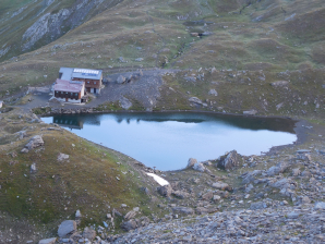
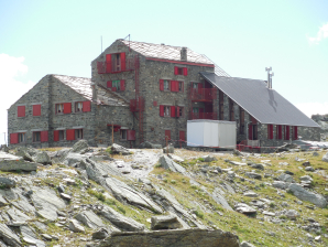
Rif LagoVerde (2583m): 
Language: Italian, French (pleasant people, relatively young)
Tel: +39/348/6009920 (valley – winter)
+39/0121/806124 (cabin)
rifugiolagoverde@outlook.com
angy.meloni@live.it
56 beds (CAI)
Open: 15/06 to 20/09
Half-board: 56€ on the dormitory (2024)(room for me alone)
Dinner at 19.00hrs:
0°: Sandwiches
1°: Pasta or soup
2°: Rabbit with plums!!!
3°: Cheese
4°: Dolce
5°: Schnaps
(Very large portions and delicious)
Breakfast (7.00 AM):
Extensive Italian: bread with jam only, cornflakes, milk, biscuits, toast. Coffee or (green) tea and fruit juice!! (Quite spacious for a high cabin where everything is brought in by helicopter.)
Day 32 Rif LagoVerde – Rif Jervis 10.1km +613m 1453m

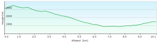 This day is only partly based on the Rother guide. The route proposed here is simpler and easier than the variant proposed by Rother. Don’t expect too many indications, however, in terms of signposts on the terrain. Only at the Rifugio Lago Verde, you will find a signpost to the Rifugio Jervis and of course if you choose at the Alpe Crossena to descend to the main route from Villanova to the Rifugio Jervis. But between the Col Valpreveyre and the Alpe Crossena, you will look in vain for signs to the Rifugio Jervis.
Leave the Rifugio Lago Verde and walk to the right of the lake on the short side in the direction of the nearest mountain slope. Along the Italian side, the path is well marked. As mentioned, here you’ll find a signpost to the Rifugio Jervis and the Bivacco Soardi (2620m). Depending on the map material, you will reach a col called: Col Val Preveire (Valpreveyre) (2746m) after 15 minutes. On the other side (France) you should lose as little height as possible and walk around the Bric Bucie (2998m). To do this, use a path that runs in the flank of the aforementioned mountain, which is vaguely marked yellow. Especially at GPS S3202, you have to be careful not to go back up too fast and follow a vague path towards a pass between the Bric Bucie (2998m) and the Bouciret (2936m). You descend a little towards GPS S3203, where you can already find traces of a vague path towards the aforementioned col. You keep descending gradually until you find a path at GPS S3204 that is only marked with cairns. Follow this path until just below the Col Boucie (2630m). Here you return to the Italian side. The Bivacco Soardi (2620m) is just below the col.
Bivacco Soardi (2620m): 
This bivouac differs from what is usually understood by Italy as a bivouac. This bivouac is actually a small hut. It’s manned in July and August. There are 15 beds and a very limited choice of food is available (soup and pasta only). Water comes from a well just below the hut.
The path descends in a zigzag direction towards the source, from where it changes into a slightly descending path, followed by a slightly ascending traverse towards Col Di Boina (2412m). The pass is marked by a barrier for cattle.
A little lower, you’ll find a junction (S3209), where you take the descending path to the left. The ascending path leads to Col Malaurat (2603 or 2534m) and France. Especially the French make a round trip here in combination with the Col Boucie.
You descend to waypoint S3210, where you go to the left and stay at the same level until you descend 650m further in zigzag until you come close to the river. From here, the declination of the slope decreases until you find a signpost and a junction at S3211 (Alpe Crosenna 1654m), just above an alpine farm.
From here there are two possibilities:
- Take the ascending path towards the Colle Del l’Urina (2523m) until the Col Bufafol (1927m), then start the descent towards Refugio Jervis (1732m).
- You descend near the alpine farm with stray dogs to a bend (1475m) in the gravel road between Villanova and Rifugio Jervis. Here you also start the climb, along a boring gravel road with a number of crossings, in the direction of Rifugio Jervis (1732m).
Walking time without rest: approx. 5h00′ variant via Col Bufafol: approx. 5h30′.
1.0L of water
Rifugio Jervis (1732m): 

Language: Italian, French
Tel: +39/338/6385677 (valley – winter)
+39/0121/932755 (cabin)
80 beds (CAI)
Open: all year round
Half-board: 56€ on the dormitory (2024)(room for me alone)
Dinner 19:30hrs:
0°: anti-paste: cold cuts
2°: polenta with 2 kinds of meat
3°: cheese
4°: cake
(Very large portions, delicious, except for the eternal polenta)
Breakfast (7:00 AM):
Extensive Italian: bread, jam, cheese, meat, muesli, milk. Coffee or (green) tea.
(self-service, very large choice)
Day 33 Rif Jervis – Pian del Ré 17.0km +1573m 1258m

 Leave the Rifugio Jervis and walk back to the first signpost. Here you turn right and descend towards the river and the gravel road through the valley. You cross the Torrente Pèllice via a bridge to cross a fence consecutively. Here you will find a signpost in the direction of Rifugio Barabara Lowrie. Once in the meadow, the track is difficult to follow because of the many cow tracks and the lack of painted signs. You climb diagonally right up in the direction of the road. Follow it a little to the left and then leave it for a path. However, the first shortcuts are very steep and you can, therefore, consider just following the road. Higher up, the shortcuts become less steep. The marking here is a combination of old yellow characters and red and white. The routes along the mountain road are sometimes unmarked over longer distances. You come to the top of a hairpin bend, which turns out to be the cows’ favorite dung spot. You follow this road to a saddle with stables. Further down the road, there is another short cut to the real Colle Barant. Just behind the col, you will find the Rifugio Barant, where there was a human presence, but where there was no direct commercial exploitation. On the Col, there is also a botanical garden, which can be visited for free.
Immediately after the Col, there is a small deviation between the tracklog and the waypoints. As the area is open, this poses a few problems. From GPS 3320 on, follow a road to a T-junction with a bench. Here you go to the right.
 At GPS 3323, you can follow the road and descend or you can follow a small path that is not marked with a signpost, but is marked along the GPS points GPS 3323 to GPS 3327, where you reach the road just before the Rifugio Barbara Lowrie.
Rifugio Barbara Lowrie:
TEL: +39 0121930077
E-MAIL:info@rifugiobarbara.it
No tarifs on the internet.
You pass the hut on the right side, after which you will find a large grassy area, where horses can walk. Follow the grassy plain to the left of the river until the end of it. There the path goes into the forest and you start the climb. This path is not a GTA-trail. It’s a short cut. The official GTA passes over the Granges della Gianna, but that means more descent and then more climbing. At a certain moment, you arrive at a more or less horizontal T-junction, where you go to the right (GPS S3332). Further on there is another stretch of path that is clear but is very badly marked. Then you reach a sign that indicates the Colle Proussera. It is a kind of lowest point, in the middle of scattered trees. Higher up, the landscape quickly becomes more open and the trail markings become better. First, you come on an intermediate saddle, after which you follow the shoulder up to the top. Then the climb flattens out. At GPS 3339 the real GTA returns to the short cut followed by Rother. After the last climb, you reach the real Colle della Gianna (2525m).
Just below the Col, you will find a junction between the paths to Pian Melzé and Albergo Pian del Rey. Unless you want to abort the trip, the descent to Pian Melzé is completely unnecessary. By descending to Albergo Pian del Ré you save 270m of descent and 270m of climbing the next day. Especially the beginning of the path to Albergo Pian del Ré looks better than the path to Pian Melzé. It takes a long time before the path to Albergo Pian del Ré starts the final descent. You’ll stay at the same height for a long time, even climbing to a saddle on a ridge of the Truc Teston.
At GPS 3342, you arrive at a jeep road, which you follow downhill to the left. You arrive at the (paying) parking under the Albergo Pian del Ré and cross it to go to the Albergo with red shutters itself.
Walking time without rest: 6h30′ with rest: approx. 7h00′.
0,5L water (supply in Rifugio Jervis)
Albergo Pian del Ré (2020m): 

Language: Italian, French
Tel: +39/349/5315921
+39/0175/94967
50 beds
Open: mid-June to the end of September
Half-board: 70€ (2023) in a room with shared sanitary facilities
2 glasses of red wine: 5,50€
Dinner 19:30hrs.
2°: again polenta with sausage in tomato sauce and again beef stew
3°: several sauces, including cheese sauce, anchovy sauce, Boursin and fruit jelly
(Served all together. Very large portions, but no vision)
Breakfast (7:30 AM): Extensive Italian: 2 sandwiches, 1 croissant, jam, muesli, milk. Pot of yogurt. Coffee or tea.
Day 34 Pian del Ré – Rif Bagnour 15.7km +1132m 1126m
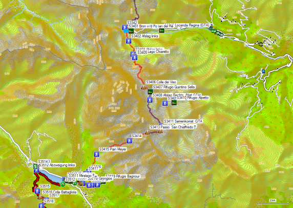

 From the Albergo, you follow a narrow path towards the river. A little further you reach the Source of the river Po. Beyond it, the path takes on the climb in the flank of the slope. Higher up, you’ll soon arrive at the Lago Fiorenza. This area is a regional natural park and the Rifugio Quintino Sella is also very well known. On a clear day, this leads to the presence of many day hikers. The path is strongly eroded locally, especially because the Italians cannot suppress their urge to use short cuts or direttissima.
Just before Lago Chiaretto, all tourists are directed to the right, via the long road to the Rifugio Quintino Sella. This road runs straight underneath a vertical wall and is potentially dangerous because of the risk of falling rocks. If you want to take the shortest route, you have to follow the sign Rifugio Arpetto to the left. Further on you’ll find another wooden sign Arpetto to the left. Here you go straight on via a marked, but not signposted path. After a bumpy path on the left bank of the lake, you start the climb in the slope. Higher up the path joins again with the path V13 that followed the other shore of the lake. The path goes even further to the left and then climbs to just above a snowfield to get into the bowl under the Colle del Viso. The route through this bowl is erratic. Just before the pass itself, you go to the left against the mountain flank to reach the pass. After the pass, the landscape is almost lovely in comparison to the stony bowl you just left. It goes on to the Quintino Sella hut, which was being enlarged in 2013.
Tel: +39 0125 366113
Gsm: +39 348 8107793
rifugioquintinosella@gmail.com
Half board: 80€ (2024 – members )
 You round the hut and continue along the lake to the end of it. At the end of the lake, you will find a path to a pass (2901m). Further on, just before a small lake, you’ll find the junction between the path to the Rifugio Arpetto (left) and the Passo San Chiaffredo. The path is a stony traverse in the flank up to GPS S3411 (Meeting GTA). From here on, you can tackle the final climb to the Passo Gallarino. From this pass, it continues along the right flank to the Passo San Chiaffredo.
 On the pass, you’ll find a signpost to the Rifugio Bagnour 3h30′. However, please note that the road through the valley may not be shorter in distance, but it is shorter in walking time, namely 2h40′ (Rother, 2h15′ actually). If the weather conditions are favorable, you can consider this longer version. Near Lago Bertin, you will find a lot of large cairns At the end of the lake, you descend through a kind of gorge, where the waymarks are weak.
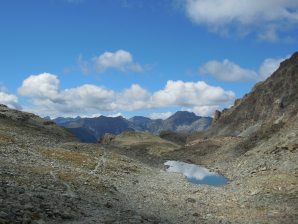 You remain to the left of the river and don’t be fooled by the access path (GPS S3414) to the Bivacco Bertoglio which lies like an eagle’s nest on top of the rock face. The path towards it is “difficult”. The further descent to the Pian Meyer is trouble-free.
 On the Pian Meyer, you’ll find a patchwork of signs to all kinds of Rifugios, including the Bagnour. The path itself is quite clear, but the markings are weak. Mainly you follow signs with VTT but also red stripes and sometimes triangular red flags. Your own recorded waypoints differ from the Rother tracklog. At the end, you’ll find yourself on a wider road, which you’ll leave for a steeper climbing path between the trees up to the Rifugio Bagnour.
Walking time without rest: 6h15′ with rest: ca 6h45′
1.0L of water
Rifugio Bagnour (2017m):
Language: Italian
Tel: +39/320/4260190
www.rifugiobagnour.it Site not available, Facebook is.
20 beds
Open: mid-June to end of September
Half-board: No recent tarifs online
Dinner 19:30hrs.
0°: anti-paste: kir (aperitif) with deep-fried dough stalks
1°: risotto
2°: leg guards with beans
3°: cake
(Rather small portions)
Breakfast (7:00 AM): Extensive Italian: home-baked dark bread, chocolate, jam, coffee or (green) tea.
Day 35 Rif Bagnour – Rif Melezè 15.8km +1107m 1303m

 You leave the Rifugio Bagnour by the same road along which you reached it yesterday, up to the point where you reached the wide road (GPS S3418). From here you descend via this wide road to GPS S3504, where you take a little path to the left and pass behind the :
Rifugio Grongios (GPS S3506):
Half-board 85€ + 20€ for single use of the room (expensive!!!).
From here you follow a wider road again until you reach the asphalt near the
Rifugio Aleve GPS S3508 (Closed?):
www.rifugioaleve.it (site not available!!!)
Half-boar: ?
Follow the asphalt to the right. You pass a covered picnic table at GPS S3509. Follow the asphalt through Frazione Castello. When the main road passes along the lake, you turn left and follow this bank of the lake to the dam. You cross the dam, to return to the right lake bank. At first, this is still a jeep road, which turns into a path halfway along the lake, and at this moment it passes more rocky passages.
At the end of the lake, just after passing a (sometimes dry) streambed, you’ll find a simple wooden sign with the inscription: Battagliola. This is where you have to turn left.
However, it is advisable to first enter the village of Maddalena to replenish your stock of cash (GPS S3514) and provisions (GPS S3513).
The path to the Colletto Battagliola is brutally steep until you arrive above the tree line. Hence the climb becomes less steep. The climb ends at a sort of intermediate pass (GPS S3515) to continue in a traverse to the real Colletto Battagliola (GPS S3516). On the pass, you turn left. The Rother tracklog steers you towards unmarked short cuts of the jeep road, which you may wonder if it makes sense to follow instead of just following the road. Especially the last cut off for the first “Grange” concerns one with clayey soil that has been trampled to shreds by cows, which are bone-hard in dry weather and pappy in humid weather.
At GPS S3519 you will find the junction to Chiesa (grass road on the left). In the direction of Chiazale, follow the gravel road until you reach the asphalt at GPS S3520. Here you go uphill to the right and follow the asphalt in the direction of Celle and Chiazale.
In Chiazale you will find Agriturismo Lou Saret (Closed?).
Agriturismo Lou Saret:
Chiazale 27, Bellino, Italy
+39 347 975 3899
lousaret@libero.it
http://www.agriturismolousaret.it (not available!!!)
It is more budget-friendly to follow the asphalt 1.5 km further and to spend the night in the
Walking time without rest: 4h30′ with rest: ca 5h30′
1.0L of water
Rifugio Melezè (1806m):
Language: Italian, French
+39 335 135 7322
+39 328 144 4923
Tel: +39/0175/95338
54 beds
Open: mid-June to mid-September
Half-board: 58€ All in (2024) (alone in a dormitory)
1/4L Red wine: included
Dinner 19:30hrs:
0°: anti-paste: none
1°: pasta
2°: chicken with peas from cans
3°: pannacotta
(Rather small portions. Especially disturbing was the fact that the crew ate steak, sausage, lettuce and tomato with guests).
Breakfast (7:30 AM): Extensive Italian: bread, toast, muesli, fruit juice, each with 1 small pack of chocolate, jam & honey. Coffee or (green) tea.
Day 36 Rif Melezè – Campo Base 15.3km +1017m 1135m

 Leave the Rifugio Melezè and turn right on the tarmac. You follow this to the hamlet of Santa Anna, where the asphalt ends. After the last house, cross the river and continue straight on via a gravel road. At a parking lot overlooking the Rocca Senghi, you will find a sign with an explanation of the minimum equipment for ascending the Via Ferrata on the Rocca Senghi. If you want to know more, you can find several videos on YouTube. From the parking lot, the road is forbidden for traffic in general. The road also gets rougher (jeep road) and crosses 2 bridges, after which it leads to a first alpine meadow with a hut. The jeep road makes a detour here, so you follow a somewhat vague track parallel to the stream until it ends up on the gravel road again. Then you cross a tributary and enter the gorge of the main river. Especially in the higher part of the gap this results in “nice” images. You just have to think that the cows are also coming off the mountain pasture on this route at the end of the season. Once out of the gorge, you come back to an alpine meadow and follow a trail that is partly due to footsteps, but also partly due to the use of trail bikes. Here, too, the new generation of shepherds use these machines to monitor the cows on the high mountain pastures. In function of the contours of the landscape, the path does have a logical course, which may not be so clear on the map :-).
 At GPS S6312 you’ll find the junction between the path to the Col de l’Autaret (FR – straight on) and the Col di Bellino (left). At GPS S3614 you’ll find another junction with a very vague path in the direction of a hut and pass located to the left of the Col di Bellino. The path to the Col di Bellino is not to be missed. If you’re lucky, you’ll find edelweiss among the loose stones here.
As is often the case in this region, the north side of the Col di Bellino is stony, where the south side is more like an alpine pasture. In the highest part under the pass, the path is very good. At a lower altitude, however, you get into the cow’s territory, and there it is again searching for the right path. There is also a difference between the Rother tracklog and the path drawn on the (paper) staff map. The Rother tracklog mainly follows cattle tracks on the right bank of the main river, close to the border mountain range and this in the direction of an alpine farm and the road to the Colle del Morin. The road drawn on the staff maps splits from the Rother tracklog near GPS S3617 and then follows the left bank of the mountain river, crosses a tributary coming from the Monte Eighier twice and then follows it to the Grange Collet, where the two variants come together again.
At the Grange Collet, there is an unofficial parking lot. The cars go to the right to find the best way. Walkers go straight on and follow a narrower road, which descends faster and crosses the first road back a lower altitude. In 2013, there were works of a hydraulic nature in progress here, probably in view of the production of hydroelectricity. Follow the narrower road on the right bank of the river to a camping site for camper vans and the lower situated Campo Base.
Walking time without rest: 5h00′ no rest was taken (non-stop)
1.0L of water
Rifugio Campo Base (1650m):
Language: Italian, French, English
Tel: +39/0171/99068
(+39) 334 8416041
26 beds
Open: all year round
Full-board: 59€ (55€ -5% member discount) (with three on chamber dormitory of 8 persons) (2024)
Lunch: 13:00hrs:
0°: anti-paste:
1°: pasta
2°: cutlet with carrot
3°: dessert
Dinner 19:30hrs:
0°: anti-paste: none
1°: pasta
2°: meat with vegetables
3°: ice cream with real strawberries!!!
(Rather small portions)
Breakfast (6h30′ or 07h30′): Extensive Italian: bread (large), muesli, jam, ham!!!.! Coffee or (only black) tea.
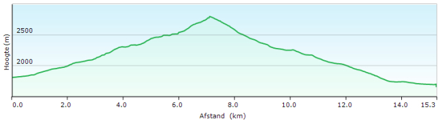
Day 37 Campo Base – Pontbernardo 25.4km +1489m 1772m

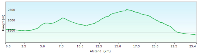 A double stage, but this saves you 337m of descending and ascending the next morning. You can shorten them by spending the night in Saretto instead of in Campo Base.
Taverna di Diego
(www.dadiego.it ) (Limited functionality of the website dated 2022???) – 55€ Half-board)
You leave Campo Base and descend via the asphalt through Chiappera. You pass the cemetery and 150m further you leave the road in a bend for a forest road/path. The path remains at the same level for a long time. There’s a lot of turns, but you keep going in the same direction.
Just before the Sorgenti del Maira, the variant via the Bivacco Bonelli and the Colle d’Enchiausa is indicated by a sign to the right. This variant extends the stage by 2 hours and can only be considered for those who stop in Chialvetta.
Just before the Sorgento di Maira, walk over the lids of a drainage canal. You hit the road from Saretto. You can follow this until just past a hairpin bend. Here you turn left via a small bridge and then you climb to the sanitary facilities of the campsite (containers), where you will find a better forest road, which you follow to the left uphill, away from the campsite for mobile homes on the Sorgento di Maira.
Cows can be found on the meadows. You have to ignore one more turn to the left. Continue straight on until you reach the Colle Ciarbonet. The path to the Col is marshy and eroded by the cows and mountain bikes.
Once you cross the pass you will find a good road, but it descends very slowly. The Rother tracklog follows the short cuts, of which the higher ones are almost invisible on the terrain. So you really need to follow your GPS and look closely at the terrain to make the short cuts in a safe way. Lower down the slope, the short cuts become clearer and easier to follow. You descend to a parking lot along the road, where the day hikers leave their vehicle for the climb to the Rifugio Gardetta.
 The Rother tracklog descends a little further towards Chialvetta, but that is, of course, unnecessary for those who combine the two stages. At GPS S3717 you take the exit to the right (rising road) and do not descend further. At GPS S3718 the tracklog from the valley comes back at the road to the Rifugio Gardetta.
Rifugio Gardetta:
Follow the jeep road until you see a signpost and then take the path to the left. The last part of the road/path between the bunkers is very eroded (mountain bikes?). From the Passo della Gardetta, you have a beautiful view of the lower situated Rifugio Gardetta. The GTA, however, follows an old military road in the flank of the mountain to the Passo di Rocca Brancia.
Just past the pass, the Rother tracklog follows the slowly descending road, where there is also a good shortcut straight ahead. At the lowest point of the road, leave it for a path to the left. The signposts are plastic plates glued to the rock and marked with an alcohol pen. The direction to follow is indicated as P Servagno and V. Stura.
The first part of the path is clearly visible. Once you get to the alpine meadows, the path fades due to the presence of the cows. Near GPS S3728 you will find a small shepherd’s hut. Here you have to pass through an elongated stretch that is completely covered with cowpats. After this part, you will find a normal path again until you reach the asphalt.
On the tarmac turn left and descend towards Pontebenardo. At the falling stones gallery, you first walk next to this gallery until you reach the old road. Follow this road to the exit of the tunnel where the old road joins the new one.
When you see the church, you descend diagonally to the left via a path. You go through the village until GPS S3733 Pension Le Barricate (Half board: 45€ Dormitory, Half board in a room 1p: 85€ (2024)) or on the left, on the village square, you will find the Posto tappa on GPS S3732. (22beds)
The upstairs neighbor of the Posta tapa uses it as a kind of extension of his own home. At the weekend, he’s lodging there drunk guys, and that’s not pleasant. The house is unheated and therefore there is a musty smell.
For the small price difference, you are better off at Pension Le Barricate itself. (Italian only)
Le Barricate
Via Delle Alpi, 16
12010 Pontebernardo
Pietraporzio (CN) Italy
Tel: +39 0171 96616
Email: lebarricate.gta@libero.it
Pension Le Barricate (H/P: 45€ Lager, H/P op Kamer 1p: 85€ (2024))
For dinner, you go here to restaurant Osteria Le Pecora Nera (GPS S3731 – Italian, English). If you sign up with one of the two, they’ll pass this on to each other. At the restaurant, you’re expected at 19:00hrs. punctually. The Italians arrive at 20:00hrs. As the number of seats in the restaurant is limited, this way you don’t take the place of other guests, who eat a la carte and therefore yield more.
Osteria Le Pecora Nera (GPS S3731 – Italian, English)
1°: Risotto in barbera (wine)
2°: Breaded chicken breast, zucchini, and potato in tomato sauce
3°: Cheese dish
Menu: Current price unknown.
Breakfast: bread, packaged croissant, jam, local honey, coffee or (green) tea.
Walking time without rest: 8h15′ with rest: 9h00′
2.0L water (in hot weather)
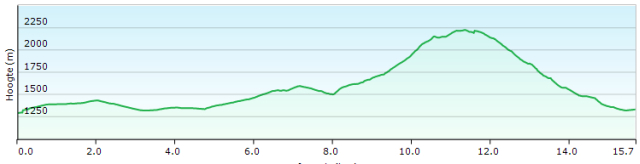
Day 38 Pontbernardo – Strepeis 15.7km +1215m 1175m
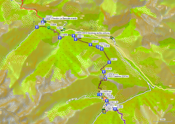
 The route proposed by Rother between Pontebernardo and Stepeis is far too long. It covers almost 20 pages in the guide. If you have endless time, you are free to follow this.
The route proposed here is the shortest. Parts of the route is not GTA and was therefore logged.
From Pension Le Barricate walk back to the main road. Here you go a few meters to the right, and then take the ascending road to the left. In the first hairpin bend, you will find a small path to cut off the second hairpin bend. You continue your way up. At an intersection, the white-red markings go to the right. You continue straight on, make a bend to the left and then cross the river. The road climbs back towards the main valley. This is followed by a false flat until the road really starts to climb again to GPS S3807. Then it descends into the side valley until you cross the road from the main valley (GPS S3808). You cross this road and then the bridge over the tributary.
You’ll start the climb again towards the main valley. Once back in the main valley, the road undulates. After a first mountain stream, you’ll find at GPS S3810 a partially overgrown gravel road, which you follow up to the right via 4 hairpin bends. Then the path slowly climbs into the flank. At GPS S3813 you will find a signpost to the right towards Monte Vaccia. Continue straight on and at GPS S3814 there is a road from the valley. A little further on there is a fork in the road and you go to the right, after which you run into a chain over the road.
 At GPS S3818 you can leave the road for a path that ends at a signpost. Here you go left up to a water collection point. Or you can follow the increasingly overgrown road to a water collection point.
Here you will find the GTA again. The path next to the water collection point initially climbs very steeply, but higher up the slope softens. When the vegetation changes, you will find a lot of blueberries in the season. The path climbs in a zigzag through the open slope, and at the end of it turns left towards an in-between col. Then you descend a bit, to climb again to a second intermediate col. Here you will find a plain with two ruins. The path runs to the left of the left ruin and turns to the left to reach the real col Caserma (2241m).
The descent is very nice, except for the last part shortly before Baita Luca, which is very stony.
At GPS S3823 you leave the GTA again for a shorter route in the direction of Strepeis. At the fork in the road, turn left in the direction of the hamlet. At the end, you turn right and descend towards a bridge over the river. Here you go up lightly and reach the asphalt road. You cross the hamlet of Besmorello and just after a right turn you leave the asphalt for a path. You descend towards Bagni Di Vinadio.
In the village, you will find a grocery store (GPS S3830), where you can replenish your supplies. From the central parking lot, you can go down via a path (GPS S3831) in the direction of Strepeis. Once back on the tarmac you turn right towards Strepeis.
Walking time without rest: 5h45′ with rest: approx. 6h15′
1.0L of water
Albergo Strepeis (1281m):
Language: Italian, French, English
Owner: Margherita Degioanni
Frazione Strepeis 16, Vinadio, Italy
Tel: +39 0171 95831
Cell: +39 3383691707
20 beds
Open: mid-June to mid-September
Half-board: 56€ (in a room alone) (2023)
Posto Tappa: (tent-shaped building at the campsite)
Actual price unknown. Half-board shower with coin.
Dinner 19:30hrs.
0°: anti-paste: 4 kinds
1°: pasta or soup
2°: meat with real fresh vegetables
3°: dolce or fruit
Breakfast (8:00 AM): Standard Italian: bread, muesli, chocolate, jam. Coffee or (green) tea.
Day 39 Strepeis – St Anna 9,1km +1132m 382m
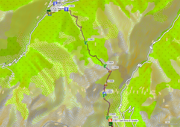
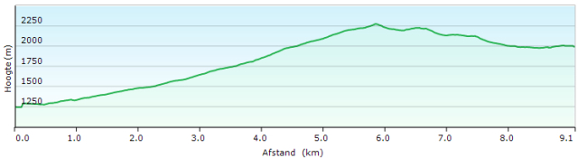 Rother chooses its own route here. The total distance is longer, the distance over the paved road is longer, the difference in height is greater.
The start of the GTA trajectory is not very attractive either. The second part is nice.
Leave the Albergo Strepeis to the right and cross the parking in the direction of the wooden bridge over the river. You cross it and follow the gravel road to the left. After 350m there is a junction between a road that continues to follow the river and one that rises slowly. In an open space, it flattens out and becomes vaguer. You descend a bit and arrive at a road that rises from the bridge at Bagni Di Vinadio. Higher up at GPS S3902 you will find a signpost for the Passo di Bravaria. The road is steep and unpleasant and ends as a road near GPS 3903, where it turns into a path and crosses the river.
From here, the path is slower to climb and more pleasant to walk on. With GPS S3904 you cross a branch of the upper reaches of the river; a little later you are on the pass. On the pass, you reach sounds of civilization in the form of noise from cars that drive on the road in the valley.
After the pass, turn right and stay on the same level for a long time. At GPS S3906 you cross a saddle and then slowly descend towards the junction of the path to the Laghi Muton or Gemelli. A little further on, you’re blocking the outlet of a small lake with swamp lint plants.
 The path descends a bit and then crosses the river again until you cross the river just below a locked up building near Sant’Anna di Vinadio. At this building, you will find a paved road to the Rifugio San Gioacchino, which is the property of the monastery. The map from the Rother guide shows a longer route that leads to their proposed route on the rock with a statue of Mary, which you still pass on your way to the Colle della Lombarda on day 40.
Walking time without rest: 3h15′ with rest: ca 3h45′
0.5L water
Rifugio San Gioacchino (2035m):
Language: Italian, French,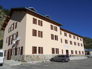
Frazione Sant’Anna, Vinadio, CN
2035 mt
Tel: +39 392 545 6245 – +39 0171 959125
https://www.santannadivinadio.it/ospitalita/#camere (Starting from in communal room: H/P: 40€ – 2024)
Email: prenotazioni@santuariosantanna.eu
Open: early June to late September
Half-board: 53€ (in a room alone, very nice, antique roof beams in combination with many home automation. You have to keep the door of the bathroom closed, otherwise, the ventilator in the bathroom will always be switched on.)
Dinner 19:30hrs.
0°: anti-paste: none
1°: pasta or soup
2°: turkey with tomato and endive (been given a second serving, so more than enough)
3°: dolce
Breakfast (8:00 AM): Large Italian breakfast in self-service: bread, toast, croissant cornflakes, fruit juice, chocolate, jam. Coffee or tea (no green)
+Day 40 St Anna – Rif Malinvern 12,3km +813m -975m

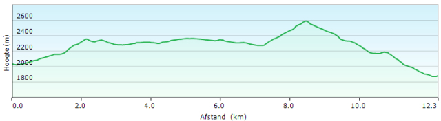 You leave the hostel and descend to the right until you reach the place where you can choose between the descending and the ascending road. You take the ascending road and follow it to a parking place. Here the road surface changes from asphalt into a rough 4×4 road, that rounds the rock with the statue of the Virgin and climbs further to a fork in the road (GPS S4002), where you turn left. You pass a little lake whose banks are dotted with cow manure. Then you climb to a pass via a rough old military road.
At the top, you enter a relatively flat area. The path follows the border stones in the direction of Colle della Lombarda. This Col is a popular pass for motorcyclists and cyclists, who pose there at the nameplate on the col.
From the pass, you follow a path that you have to improvise. With GPS S4010 you reach the road again, which you cross to find a vague path parallel to the road towards an S-turn. From here on, you follow the road to a path, at the height of a wooden pole without signposts, that rises to the right on the slope. Only at GPS S4013, you will find a real signpost towards Passo d’Orgials and the Rifugio Malinvern.
Both the climb to and the descent from the Passo d’Orgials can be considered as difficult. High shoes are advisable. The last part of the descent just before the Rifugio Malinvern is marshy due to the presence of streams. Moreover, the path is not properly marked at that very spot, so it is best to follow the mud
Once down, you can’t see the hut itself, because of the trees there. You have to orientate on a blue tent, to the right of the hut and the off-road vehicle of the proprietor at the bottom of the hut.
Walking time without rest: 4h15′ with rest: approx. 5h00′
1.0L of water
Rif Malinvern (1839m):
Language: Italian, French, English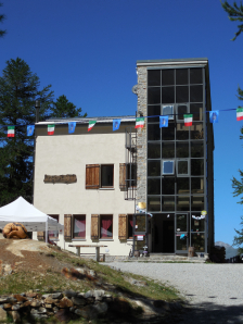
Tel: +39 0171 1936018
Gsm: +39 340 2768964
Gsm: +39 348 1119086
Open: mid-June to mid-September
Half-board: 48€ (2024) (alone in chamber dormitory)
Dinner 19:30hrs.
0°: anti-paste: none
1°: polentaL
2°: meat in tomato sauce, sausage in gorgonzola sauce, 4 kinds of cheese sauce, tomatoes, and bread
3°: cake
(too much!!!)
Breakfast (7:00 AM): Large Italian breakfast: little bread, 1 fresh toast, lots of cake, chocolate, jam. Coffee or tea (green)
Day 41 Malinvern – Rif M Buzzi 19,4km +1732m 1297m

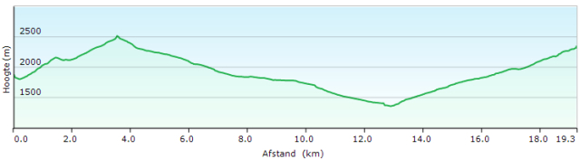 You leave the hut through the front door and walk straight ahead. In the hairpin bend, you’ll find a signpost and follow the path down to the bridge over the river. On the other side, you follow the river downstream. After about 40m you’ll find a path that goes up against the slope in the direction of the valley. A little higher, at GPS S4101, you’ll meet the path that comes straight out of the valley. From here you continue uphill. The path goes up at the foot of the rock-wall to a kind of in-between pass, after which you descend in the direction of Lago Malinvern.
You round this lake in a counter-clockwise direction. You cross the exit of the lake to climb along the right side of the valley to a partly snow-filled bowl under the pass. You round it clockwise to arrive at the Colletto di Valscura (GPS S4103).
From the pass, a beautiful path descends to the first lake Lago di Valscura. Just before the lake, keep to the left until you cross the exit of the lake to reach the access road. Descend along this mountain road. There are a number of shortcuts, but these are technically difficult. The first signposted exit can be found at GPS S4105 (Turn right). Here you follow the old military road, where the road you left descends slower and goes through a tunnel. Lower down the slope, both roads join again. Further on, you will find a sign that politely asks you not to use any more shortcuts because of the erosion. You can find another one between GPS 4106 and GPS 4107. Lower down the slope, you can only follow the road down to the valley.
In the valley, you walk along the banks of the Torrente Gesso Della Valletta. In 2013 there were problems with a bridge over a tributary near GPS S4108. The bridge over the main river at GPS S4109 is fine.
From this bridge to the Rifugio Valasco (GPS S4110) (Half-board: 55€ + 10€ (Single occupation)) the road is a real horror for your feet because of the quantity of loose material on the road surface.
Rifugio Valasco:
Via Monte Carbonet, 22
12011 Borgo San Dalmazzo (CN)
tel. +39 0171 1836267
Rifugio, VoIP, Between 8.30-10.30 and 15.00-18.00
Cell: +39 347 0531456
(Proprietor, doesn’t function while in the hut)
Cell +39 353 4086027
(reservations via WhatsApp)
(Half boarde: 55€ + 10€ (Single use))
The Rifugio Valasco, by the way, is an abomination to the eye. From this rifugio on, the road is better.
With GPS S4111 you can leave it for a path that either runs just below the road or cuts short the hairpin bends. The path is more pleasant for the feet and also offers more shade than the jeep road. The path touches the road several times, at the successive GPS points. It is not marked, but it is maintained and well visible for those who are not completely asleep. From GPS S4116 on, there is no escape from the road anymore, but then it is almost flat and the road surface is fine. Between GPS S4117 and GPS S4118, you will find several car parks and you have to find your way towards the asphalt, which you will find near GPS S4118 or GPS S4118 Albergo Turismo (H/P: 75€). You descend via the asphalt to pass along the back of the Hotel Royal Terme Reali di Valdieri (GPS S4119) (H/P: 110-130 single occupation).
All the accommodation points look like sadness all over the place. Too ugly, too expensive, and above all, glory long gone. The picture in the Rother guide of the pool is deceptive. In the picture, the pool looks much bigger than it really is. It is also located right next to the asphalt road, so privacy is zero and you also have to wear a bathing cap. The visitors seem to be seeking refuge for diseases of civilization such as obesity, which are avoidable.
The funny thing about the picture in the Rother guide is also that Dieter Haas (co-author of the guide) keeps his feet on dry land :-). Soaking your feet in a swimming pool is very bad for your skin and increases the risk of blistering.
Other walkers who did stay overnight in Terme di Valdieri used the Posto Tappa in the hotel Hotel Royal Terme Reali di Valdieri. They were not very positive about the atmosphere and the food. An alternative is to continue to the Rifugio Morelli-Buzzi, but also there are comments about the food and sleeping comfort.
Just below the hotel and just before the bridge over the river you will find a picnic area with stone benches and tables and water taps (water-flow unchecked).
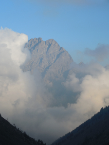 Before the bridge turn right into the parking lot. Here you will find a signpost to the Rifugio Morelli-Buzzi at the beginning of the path. Walk up to the river and follow it upstream to the bridge. You cross the river via the aforementioned bridge and on the other side, you will find an old military road in the forest that climbs slowly and in a zigzag to the top of the tree line. As the forest becomes thinner, the path slowly approaches the river, which in turn disappears under the rocks.
At GPS S4122 you’ll find the exit to the Bivacco S Varrone, which you can see as a red- and yellow-painted eagle’s nest in the flank to your right.
From here on, you can also see the Rifugio Morelli-Buzzi, which is located about 200m below the pass. Later it disappears from sight again, because of the terrain conditions. In contrast to the Bivacco, the hut is difficult to see because of its grey-blue color blends into the landscape. In the last part, the path passes through a largely stabilized block field.
Walking time without rest: 7h30′ with rest: approx. 8h00′
2.0L of water (unless you find water in Terme di Valdieri)
Rifugio Rif Morelli Buzzi (2351m):
Language: Italian, French, English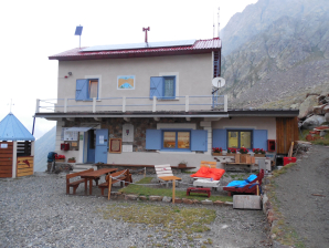
+39 0171 97394
Rifugio (Summer)
+39 348 3399722
Paolo (Cell. and Whatsapp)
Open: 12 June to 12 September
Half-board: 50€ (2024 – on dormitory, no individual rooms)
Shower: 4€ !!!! 😦
Dinner at 19:00hrs.
0°: anti-paste: none
1°: soup or pasta
2°: 2 thin slices of meat, some vegetables, bread
3°: cake
(not enough for a mountain walker 😦 )
Breakfast (7:00 AM.): Very sparse Italian breakfast: small amount of bread, 2 jams, 1 honey, 1 butter. Coffee or tea. Be sure to ask for additional bread: be assertive!!!!
Day 42 Rif M Buzzi – Rif Soria Ellena 11.6km +788m -1299m
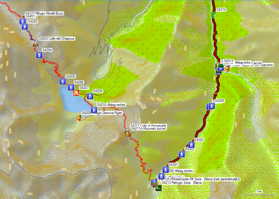
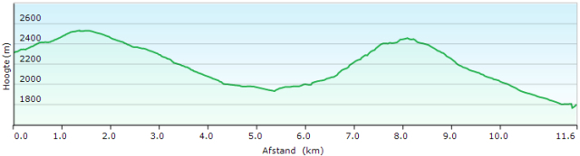 The Rother tracklog deviates from the situation on the ground when leaving the Rifugio Morelli-Buzzi. Up to the Colle del Chiapous, the tracklog (yellow) is a recording of my own.
From the hut, you descend a little along the path that led you to the hut until you reach the hairpin bend, which is actually a reversed Y-junction. You find your way to the left. You won’t find many markings, but the path is sufficiently clear. Once you’ve taken the turn-off, you’ll have few other orientation problems. You can see the pass lying above your head unless you are dealing with low hanging clouds :-). You walk purely on stones, but in most cases, it is within a stabilized environment.
You start the descent from the Colle del Chiapous (GPS S4203) along the right side of the valley. At GPS S4204 you will find a path to the right, with painted markings on the rocks. The GTA is descending further. After a few zigzag movements of the path, you cross the bowl and change sides of the valley. From here on, you keep to the left side of the valley. At GPS S4205 ignore the old military road to the right and follow the narrower path towards the dam. At GPS S4206 you find a signpost at the beginning of the dam. You cross the dam and keep to the left on the other side, away from the lake.
You descend via the asphalt road, passing through a short tunnel. At GPS S4208 you’ll find a rough jeep road, which goes up at an angle to the right. You climb again towards a dam (not in concrete now) and go to the left along the lake. You leave the jeep road at GPS S4208 just before it makes a right turn towards the Rifugio Genova-Figari (GPS S4209).
Rifugio Genova-Figari: (2020m):

Prachtige ligging tussen twee meren in een mooi keteldal.
+39 3513465666 (All year)
+39 0171 978138 (summer)
gestore@rifugiogenova.it
Open: mid-June to mid-September
Half board: 44€ (2024 – members – dorm)
A beautiful location between two lakes in a beautiful cirque.
The descent is possible towards Entraque. You save about a day, but you have to descend completely along with the asphalt. Via the GTA-Rother route proposed below, this is only about two kilometers.
With GPS S4208, a path departs that was fully serviced in 2013. The path first climbs towards a low pass directly above you. However, this is not the ultimate goal. Higher up the path begins to rise in traverse in the right direction towards the Colle di Fenestrelle (GPS S4211). Just before the col, the path descends a little bit to cross a snowfield and then climb on the other side to an in-between col. Above this pass, you will find a flat snowfield that you can cross or round on the right side until you reach the real Colle di Fenestrelle.
If you want to make a stop, you can do this better at the slightly lower ruin and find a place out of the wind.
The descent itself is quite slow. In the lower part, the pad is stonier than you would expect and even a bit swampy just before the jeep road. On the jeep road turn right and cross the bridge towards the winter cabin (Bivacco invernale). Here you will find a path that climbs towards the Rifugio Soria – Ellena (The path is steep, but the jeep road is a big detour).
Walking time without rest: 5h00′ with rest: approx. 5h45′.
1.0L of water
Rif Soria Ellen (1840m):
Language: Italian, English
rifugiosoria1840@gmail.com
+39 3516743073 (All year)
+39 0171978382 (from 15/06 tot 15/09)
Open: mid-June to mid-September (May to October only on weekends)
Run by 3 Filipino ladies, 2 of whom descend each day, to get the supplies out of the valley, partly on foot. It could be done on a mountain bike, but you have to be able to control it.
Half-board: 50€ (2024 – alone in a chamber dormitory, shower included)
Dinner at 19:00hrs.
0°: anti-paste: none
1°: soup with croutons or pasta
2°: rice, stew, and zucchini
3°: pannacotta
Breakfast (8:00 AM.): Very large Italian breakfast: bread, muesli, cheese and salami, jam, chocolate, butter. Coffee or (green) tea and fruit juice.
Day 43 Rif Soria-Ellena – Trinità 18,3km +358m -1066m

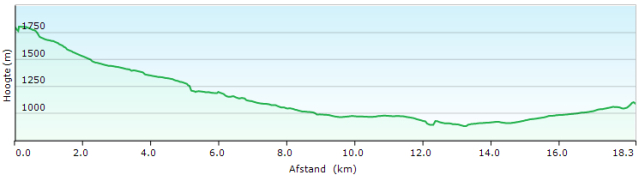 You leave the hut and return to the signpost where you reached the jeep road yesterday. Only now you descend it further. At GPS S4300, you can first cut-off the hairpin bends in the road via a path. When you notice a bridge over the main river in the valley, you can reach it from the jeep road. Less clear is that from the bridge on, you can reach the jeep road again and avoiding the road for a while.
At GPS S4302 & S4303 you’ll find another two shortcuts on the jeep road. The same applies, between the GPS points S4304 & S4305.
When entering San Giacomo you will first find a signpost (GPS S4306), then a water tap (GPS S4307) and then the Posto Tappa di San Giacomo (GPS S4308).
Posto Tappa di San Giacomo (1213m):

Dinner in the adjacent Baita Monte Gelàs
Fraz. San Giacomo, 12010, Entracque (CN)
Tel: +39/0171/978704
Open: Eastern till the end of autumn.
Half board in the dormitory : 56€ (2024)
In case of bad weather conditions, follow the asphalt road on the left bank of the river. At the bridge, the GTA goes to the right and when the weather is dry you cross this bridge. You then pass a kind of mini-camping. Here you take a path to the right of the access road to the campsite. The path runs right next to the access road between the trees and is initially somewhat vague, but marked in red and white. At the end of the asphalt road, the path continues at a varying distance from the river. At the level of a tributary, it goes up a bit. In the lower parts, the path can be a bit swampy. Most of the beds of tributaries are dry. Only one carries water and here you have to watch out for the slipperiness of the stones (GPS S4314).
At GPS S4315 you will find the split between the official GTA and the variant proposed by Rother via Entraque. The GTA route has almost exclusively disadvantages, which means that in practice it is rarely used. The main drawback is that you are missing a chance to replenish both your food and financial resources. The GTA trajectory rises and falls more, so it takes longer than the variant via Entraque, and the middle part also passes along a paved road. Only the ascent and descent are via a path.
Especially those who want to take the shorter variant via the Rifugio Don Barbera and the Rifugio San Remo can only replenish their supplies in a small shop and ATM in Limonetto (not mentioned in the Rother guide).
If you want to play safe or are not sure about the additional climb, follow the path along the main river until you reach the footbridge (GPS S4316). This is where you cross the river. Then go a little to the right along the river, to turn towards the asphalt road, which you follow to the right, crossing a bridge over a tributary. From here on, you follow the asphalt to an intersection at the dam of Entraque.
First, you pass the side road that comes from the reservoir of Chiotas (Rifugio Genova-Figari). Then walk on the high shore of the reservoir (Lago della Piastra) until you reach the dam. Just below the dam, you will find an intersection of roads.
The Rother tracklog is not very clear here and so this resulted in some searching:
- Either take a path to the left of the electricity company’s building and descend through two unlocked gates to an access road to the company’s premises. Here you turn left until you find a gravel road on your right.
- Either follow the asphalt to the left until you see the access road to the grounds of the electricity company on your right. Then you descend a little bit until you can take the gravel road to the left.
Follow this gravel road along the Torrente Gesso Di Entracque until you reach a pylon, where you cross the river via a rather ramshackle bridge. On the other side, you’ll find a path that goes up towards the village.
 The nearest shop can be found on GPS S4331. The ATM can be found near the bridge over the river in an apartment building, opposite the Albergo Pagari. Besides a room, you can also get an afternoon menu for 14€.
To leave Entraque, you have to find the Via Michele Grosso. Follow this street and pass by the Carabinieri until you reach the chapel at the end. Here you go to the right and 60m further you turn left into a gravel road. Follow this to a fork in the road (GPS S4334), where you go to the right. At GPS S4335 you cross the river via a bridge and at GPS S4336 you join a road from the right to continue in the same direction along the river. Shortly after the highest point in the road (GPS S4337), you will return to the official route of the GTA (GPS S4338). 40m further you leave the road for a smaller road sharp left (GPS S4339). Follow this 100m back and then make a right turn towards the bridge over the river. A little further on, you’ll find a garden shed with a small signpost, where the road makes a bend to the right. Follow the path straight ahead and then diagonally right towards the wall of the valley, where you’ll find a path that goes up diagonally left to the street level at GPS S4342. Here you turn left in the direction of the church and there you turn right in the direction of Albergo Locanda del Sorriso (GPS S4345).
Walking time without rest: 5h00′ with rest: approx. 6h00′ (Shopping and money collection in Entraque)
0.5L water
Albergo Locanda del Sorriso (1096m):
Taal: Italiaans, Engels, Frans
Frazione Trinità, ENTRACQUE (12010)
Tel: +39/0171/978388 (summer)
Open: mid-June to the end of September (rest of the year: weekends only)
Half-board: 50 à 60€ (2024) (Cheaper when with other guests in chamber dormitory)
Dinner at 19:00hrs.
0°: anti-paste: none
1°: pasta
2°: roast beef with onion
3°: dolce
(a little sparse in terms of quantity)
Breakfast (8:00 a.m.): Italian breakfast: plenty of (brown) bread, jam, honey, butter. Coffee or tea
Day 44 Trinità – Palanfrè 10.0km +1108m -823m

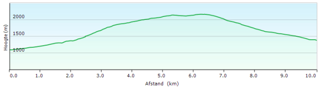 Leave the hostel through the front door and walk straight ahead into the street. After 50m you’ll find a signpost and turn right in the side road that is asphalted to GPS S4402. Here you
turn right onto the gravel road and follow it to its highest point near GPS S4403. Here you leave the road for a path that approaches the river. You climb via a rocky route at the edge of the riverbed. Steel cables have been installed here, which can be particularly useful if you have to descend this route in humid weather.
You leave the valley of the main river and then you cross the tree line to end up in open, ungrazed grasslands. You slowly climb towards a saddle, to follow the shoulder of the mountain. Then you continue in a horizontal traverse towards a second saddle (GPS S4403). After this saddle, you again continue your way in a horizontal traverse towards the real Colle della Garbella (GPS S4406).
Again, continue to the right on the ridge until you reach the highest point (GPS S4407). A short time later, you start the descent. Soon you will find yourself in a bowl with lush vegetation.
Lower down in the valley, you can see an Alpine farm. When you come close, the vegetation becomes more monotonous because of the grazing by cows. The farmer couldn’t come up with a better idea than to let you pass the electric fence twice without a gate (and then probably complain about the tourists). You follow the right side of the mountain pasture until you reach a ridge, with a view on a jeep road. Then turn sharply to the right, and descend to this jeep road (GPS S4408). 80m further you turn left at an intersection to descend further. A little further you leave the road for a stronger descending road, which you follow along the GPS-points S4410, S4411, S4412 and S4413. At this last point, you are back on a better almost horizontal road, which you follow to the left towards the asphalt in the direction of Palanfré. At the junction near a cheese farm, it does not matter much whether you follow the road along the cheese-farm or the road below. Both arrive with some climbing and descending at the Locanda del Parco L’Arbergh (GPS S4416).
Walking time without rest: 3h45′ with rest: approx. 4h00′
1.0L of water
Locanda del Parco L’Arbergh (1379m): 

Taal: Italian
info@rifugiolarbergh.it
Tel: +39/340/6973954 (zomer)
Open: gans het jaar
Half board: 70€ (2024) (New proprietors… Possibly new way of doing things…..)
Dinner 19:30hrs.
0°: anti-paste: 2 x
1°: pasta
2°: none!!!!!!!!
3°: dolce (Very crowded, because of a baptismal feast going on, but given the price, not acceptable)
Breakfast (8:00 AM.): Large Italian breakfast: 3 croissants, bread, toast, jam, yogurt, butter. Coffee or tea and fruit juice.
Day 45 Palanfre – San Lorenzo 10,4km +900m -783m

 You leave the Albergo and return on your steps from yesterday to GPS S4413, where you will find signposts. You just walk straight ahead on the same road. First, you go through the forest, which slowly turns into alp. At one point the path makes a sharp turn to the right and descends to the riverbed to cross it. On the other side you’ll find an arrow to the left. You continue your way along the river. Here you get the impression that the path has been changed recently compared to the GPS tracklog
The indications on the terrain in the form of signposts are good. However, the weather conditions were poor, so the GPS-positioning may have been worse than normal. The fact that the GPS goes into the inside pocket of the raincoat during rainy weather also makes the positioning of the GPS worse. In the lower part, you can see differences between the recorded GPS points and the tracklog.
Higher up, these are more in line. At GPS S4505 turn left towards Lago degli Albergh and the Passo di Ciotto Mien. At GPS S4506 you reach the junction at the Lago degli Albergh. If you go a little to the right, you’ll reach the lake itself. There are two possibilities here. You can find the best path by simply returning to the junction and following the path at the bottom of the slope. From the lake, there is a direct path a little higher up the slope, but this path is actually a path made by cows and runs through very loamy soil. This makes the soil very sticky, especially in rainy weather, it sticks easily to the soles of your shoes, which increases the risk of slipping.
After the clockwise curb, there is one in a counterclockwise direction. From here on, the slope is very steep, and the path becomes a bit technical. In the part just below the pass, steel cables were installed to secure the passage. But it is precisely, because you climb this stretch, this causes fewer problems than when in descent. Once on top of the pass, the landscape changes completely. The other side of the pass has a rather lovely character with gently inclining grass slopes and a low level of technical difficulty.
At GPS S4508 you will find a rock with signposts. The pole gave up a long time ago because of the cows’ rubbing against it. This is a split between two paths to two different cols. The direction to the valley is not indicated by a signpost. A bit lower, at GPS S4509 you’ll find a signpost that seems to be made in a private shed but is very important. It marks the junction between the path that leads directly to Limonetto (straight on) and to the right to the hotel Arrucador.
Actually, you have to make the decision where you want to spend the night in advance:
- If you are not very budget-conscious and don’t want to spend the night here on Friday or Saturday nights, you shouldn’t have much doubt and choose Arrucador. If you’re cost-conscious, you’d better avoid the extras, such as the wine list and any additional dishes in the afternoon, because they can quickly increase the bill. It is a stylish environment, but you notice that the managers are used to an audience that does not check the bill. In winter, this turns out to be a particularly rich skiing public living by the Mediterranean Sea, and in summer weekends… lovebirds, with a larger budget.
- If you do have to pay attention to a Euro, it is better to book a room early enough at Hotel Edelweiss at standard prices. This is the first hotel just below Limonetto in the hamlet of Panice Sottana. This means, however, 300m additional descent over a distance of 3.5 km and of course the next day 300m additional ascending again over a distance of 3.5 km. The hotel can be booked via booking.com. The disadvantage of a booking is of course that you are stuck with it.
- Those who are physically in good shape, and really need to look after the little ones, can also travel to the Rifugio Don Barbera (CAI) (40€ Half-board) (see description on day 46).
But if as a solo hiker, with only a triple room available at 75€ in Hotel Edelweiss, and with still insufficient insight on what day 46 is like, the choice was easily made.
To reach the hotel Arrucador turn right at the signpost at GPS S4509. You follow a narrow and less worn path through an area with long grass. On the rocks, you will find red triangles. When you arrive at an electric fence, the path becomes unclear because of the multitude of tracks made by cows. At the bottom of the meadow, you can see a stone shepherd’s hut (GPS S4510). You descend in the direction of the hut to find the beginning of a gravel road. You descend along the road along the river, which you cross via a bridge at GPS S4511 and lower again at GPS S4512. Even lower still, in a kind of plain, you arrive at a T-junction (GPS S4513). Here you turn right and cross the river again via a bridge (GPS S4514). 600m further you arrive at a kind of Y-junction, where the road to the left descends strongly and the road to the right, signposted with ‘P’ (from parking) climbs slightly. You take the last one and follow it until the terrain opens up more. You will notice a ski lift and on the right a locked-up building connected to the operation of the ski lift of which the glory days have been over for some time. To the left of you, in the middle of a gentle slope, is a rather dark looking stone building. This is the “charm hotel” Arrucador. You have to take a road to the left to get to the hotel by a detour along the back of it.
Walking time without rest: 3h45′ with rest: approx. 4h00′
In total, about 9 hours till Don Barbera… Feasible, if you are in good shape.
1.0L of water
Arrucador/B&B L’Abric (1505m):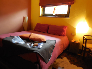
Language: Italian, German, English
Via Maestra, 16 – Limonetto, Limone Piemonte (CN)
Formerly known as Arrucador in the middle of nowhere, now L’Abric in Limonetto.
Prices: approx. €120 for 2 persons (2024). Same operators.
Hardly worthy of the name Posto Tappa. The message is to keep on going…
Dinner at 19:00hrs.
0°: anti-paste:
1°: pasta or soup
2°: meat with vegetables
3°: dolce
(morning diarrhea, which is also not allowed at this price level)
Breakfast (8:00 AM.): Generous Italian breakfast: croissant, bread, toast, jam, butter. Coffee or tea and fruit juice.
Final conclusion Arrucador: beautiful interior, exceptional location, good food with beauty faults in terms of food hygiene, very expensive wine list (up to 60 € per bottle), very little transparency at the checkout.
Day 46 San Lorenzo – Don Barbera 16,8km +1138m -575m
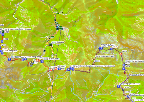
 You leave Arrucador via the access road and descend to cross the bridge over the river. On the other side, you’ll find a vague road, which you follow along the river. Higher up, the Rother tracklog and the vague road come back together. The area is quite swampy and also dotted with fresh cow manure. It’s searching for the signs to find the most ideal way up. The Rother tracklog leads you to the Colle di Tenda (GPS S4603), but that is actually unnecessary. You can shortcut this hairpin bend to the Col via a path between the GPS points S4603 & S4605. From here on, follow the road along with the forts on the border to the S4610 Cima Beccorosso.
From the Cima Beccorosso there are 2 possibilities:
- You follow the Rother tracklog that follows the gravel road along the Italian side.
- You follow a path along the French side of the border ridge. This concerns the dotted line in the Rothergids. You don’t have to pass the Fort Pepin, but you can just follow the path along the border ridge. This path was logged and can be found in the form of the yellow tracklog. The path is quite easy to follow. The indication in the form of signposts is good. The path is marked on the City Navigator Europe of Garmin. The height differences are limited.
From the Colle della Boaria (GPS S4614) the variants coincide on both sides of the border ridge, but then there are other possibilities:
- Follow the longer Rother and GTA main route via the Rifugio Garelli. It should be noted that in 2013 the Rifugio La Porta del Sole was closed, which was an additional disadvantage for the choice of the main route.
- Follow the shorter (-1 day) border ridge variant via the Rifugio Don Barbera and the unmanned Rifugio San Remo. This report describes the latter. Both variants come together again just before the Monte Saccarello and the Rifugio San Remo.
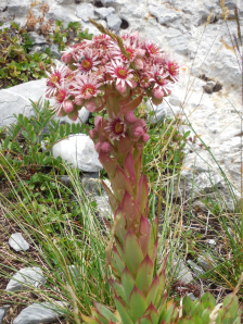 Between the Colle della Boaria (GPS S4614) and the Rifugio Don Barbera (GPS S4621) there are again 3 possibilities:
- Follow the main road to the S4615 Colla Piana (di Malaberga). Here you leave the main road towards Passo del Duca and turn right at GPS S4616 where you will find a signpost to the Rifugio Don Barbera. The path runs under the wall of the border ridge and descends towards the gravel road, which you reach just before GPS S4619, then follow this gravel road until the Colle dei Signori (GPS S4620) and the Rifugio Don Barbera (GPS S4621) located just below it. Just before GPS S4619 the road was cut short a bit, but this is not optimal (just follow the road as well :-)).
- On the Colle della Boaria (GPS S4614) you immediately take the gravel road through the bowl direction Colle dei Signori (GPS S4620) and the Rifugio Don Barbera (GPS S4621) just below it. This road makes quite a few turns, making it at least as long as Variant 1. The difference in height between Variants 1 & 2 is negligible.
- You will find your way through the bowl via the path indicated on the City Navigator Europe of Garmin (parallel dotted line). If you want to follow this path, you can make your own tracklog based on Garmin’s City Navigator Europe. At the Colle dei Signori (GPS S4620) I found a signpost towards the bowl, but the terrain conditions on-site did not show a clearly worn path. The bottom of the bowl is too much littered with scattered stones and shrubs.
Rifugio Don Barbera (2079m):

Taal: Italian, French
(+39) 0174 086157 (Hut – zomer)
(+39) 3339117975 (Winter)
Open: mid-June to mid-September
Run by a couple that is physically very different from each other, but at least they have the chain-smoking in common :-(.
Half-board: 46€ (2024 -memebers) (with 2 young mountain bikers on chamber dormitory)
Shower: 3€ (coin) Attention: solar water heater, so the temperature of the water is not guaranteed if the weather continuously cloudy.
Pasta (afternoon): 11€
Packed lunch for Rifugio San Remo: Pasta (uncooked) + sauce in a pot + grounded cheese + bread, butter, cheese, meat, and an apple: 15 €
Deposit for key Rifugio San Remo: 25€ (back in Rifugio Allavena (Colla Melosa))
Overnight stay at Rifugio San Remo: 8,50€
Dinner at 7:00 p.m.
0°: anti-paste: none
1°: pasta with cheese sauce and bacon
2°: potatoes, sausages, and stewed peppers
3°: pannacotta
Breakfast (7:00 a.m.): Italian breakfast: (large) bread, toast, jam, butter. Coffee or tea.
Day 47 Don Barbera – San Remo 16,7km +924m -955m
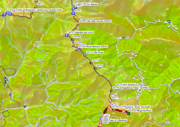
 Climb back to the Colle dei Signori (GPS S4620) and turn left on the road on the pass. At the beginning of the ridge, you’ll find a signpost and a path to the right, which circles the Cima di Pertega along the French side to reach the Colle Delle Vecchie (2097m – GPS S4705).
From this col, you can descend in 2 hours to Upega and the Rifugio La Porta del Sole, which was closed in 2013.
On the col, you’ll also find a signpost to the Colle Rossa and the Monte Bertrand. This is the direction to follow towards Rifugio San Remo. So you don’t follow the road on the Italian side, but you do follow the ridge itself. Starting from the Colle Delle Vecchie (2097m – GPS S4705) the path on the ridge is very vague. Once between the trees and especially higher up the grade, the path gets better.
After a high point, you descend to a saddle and then follow the road to the right towards France. At a ruin, turn left and return to the level of the border. A little further on you’ll find a signpost with the already known indications.
Back on the grade, at GPS S4708, you have a good overview of the further road. At GPS S4709 you leave the grade to round the Monte Bertrand (2481m – S4710A) via the Italian side since the descent of the Monte Bertrand is only suitable for chamois (which you can also notice here if you are early :-)).
At the back of the Monte Bertrand, you arrive at the Colla Rossa (GPS S4712). Here you will find a signpost to the Mont Saccarel on both the Italian and the French side. Again you can leave the pass towards Upega and the Rifugio La Porta del Sole, which was closed in 2013.
In the distance, you can already see the image of Il Redentore, on the Monte Saccarello (GPS S4718) in good weather. You keep following the border ridge. You leave it to round the Cima Ventosa (2136m – GPS S4715) via the French side. Then you descend to the Passo Tanarello (GPS S4716 – with sheepfold).
There are two possibilities here:
- You follow a vague path over the ridge, where you have to climb a bit and round up a sheepfold, and then descend to a pass on the road to the Monte Saccarello (GPS S4718).
- You follow the road from the pass along the Italian side along which you have to descend a little and then rise again towards the Monte Saccarello (GPS S4718).
From here the main route and the variant have joined together again and there are again 2 possibilities:
- You follow the road. This is particularly interesting on the way to the Rifugio San Remo.
- Follow the path that rises a little faster on the right side of the road. This is particularly interesting for hikers who followed the main route from Monesi di Triora. You arrive directly at the path that descends to the Passo di Collardente (GPS S4806), without having to go to the top of the Monte Saccarello (GPS S4718).
If you want to go to the Rifugio San Remo, you have to pass by the road at the foot of Il Redentore, and from here you have to descend along the ridge in an easterly direction. The Rifugio San Remo (GPS S4723) is not the first large brown building you pass, but a terracotta-colored smaller building with green shutters. An eye is kept on things with the help of a webcam.
Rifugio San Remo (2078m):
Language: of your choice against your travel companions, if any at all…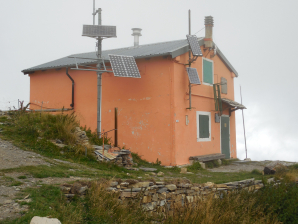
Walking time without rest: 4h45′ with rest: approx. 5h00′
1.5 to 2.0L of water (also for tomorrow)
Deposit for key Rifugio San Remo: 25€ (back in Rifugio Allavena (Colla Melosa))
Overnight stay at Rifugio San Remo: 8,50€
Dinner: What you brought yourself, supplemented with some pasta, which is usually available here.
Breakfast: What you brought yourself.
Note: Bring along a lighter or matches to light the gas fire. The function of the lighters you find on-site is not guaranteed.
The lighting is powered by 12V DC. The few sockets also provide this voltage (no 230V AC or mains voltage). The main valves of the gas can be found in the secret annex, on the way to the toilet. On the two stoves, there are also valves. As an individual traveler, you choose the small gas fire. Pay attention to the stability of the grill of the small gas fire; one support is rusted through.
Water in the kitchen can come out of the tap at the top of the sink after a lot of rain. If the water level is low, use the tap at the bottom of the sink. Do not leave taps open, even if there is no water coming out at that time. In case of heavy rain, this could be the case. The water in this hut is rainwater and should be boiled at least 10′. You can use it to cook pasta or to make tea or coffee if you leave it to cook for a long time. It is better to bring your drinking water to use along the way from the Rifugio Don Barbera.
Day 48 San Remo – Colla Melosa 15.2km +573m 1057m
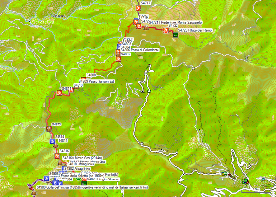
 After closing the gas bottles and all windows and doors, you return to the foot of Il Redentore.
Take the road that remains at the same level and follow it to GPS S4718. Here you are back on the main road. From here on, this is no longer the GTA, which ends in Viozene, a hamlet to the right of Upega. From Il Redentore you follow (mostly) the route of the Alta Via dei Monte Liguri, on the terrain usually indicated by AV. Every kilometer you will find a wooden pole stating the distance to Ventimiglia.
From Il Redentore you descend along the French side towards Passo di Collardente (GPS S4806). At GPS S4800 you return to a road, where several times the bends are cut short by a path. At GPS S4807 just past the Passo di Collardente (GPS S4806), you are sent to the right along the French side, via a road through the forest (Bois de Sanson). At GPS S4808 both roads come together again and a bit further on, at GPS S4808 you reach the Passo Sanson Est.
A bit further the AV goes uphill to the right, together with MBT 1 & 3. Rother chooses to follow the gravel road on the Italian side of the mountain. This road climbs slowly to its highest point (GPS S4813). There the AV returns to the Rother tracklog. Further down the road, the AV and MBT 1 leave the gravel road towards the ridge. Rother again chooses to keep following the gravel road in a descending direction. You round the Monte Grai and further on you pass underneath the Rifugio Monte Grai, which is locked up. Here you leave the gravel road for a path that descends to the left in the direction of the Colla Melosa. The path is initially dotted with stones and not pleasant to walk on. Closer to the pass, the path becomes a mulattiere, giving out on the road, that you left at the Rifugio Monte Grai. On the col itself, the road surface turns into asphalt.
Rifugio Colle Melosa (1545m):
Already closed in the first half of September.
Tel. + 39 0184.241032
H/P: 80€/ppn (Expensive!)
Rifugio Allavena (CAI) (1545m): 

Taal: Italian
Tel: +39/0184/241155
Tel: +39 01841956767
WhatsApp +39 3298922193.
Open: all year round
Run by a couple and a man.
Half-board: 46,50€ (2024 – members – alone in the room, no full-board possible despite the fact that it is a CAI cabin).
1/4L Red wine: 2,50€
Shower: 2€ (coin) Attention: let cold water out first via the washbasin, otherwise you have a cold shower (rather short).
Pasta (afternoon): 11€
Refundable deposit for key Rifugio San Remo: -25€
Dinner at 19:00hrs.
0°: anti-paste: none
1°: pasta
2°: beans and stew
3°: cake
Breakfast (7:45 AM): Typical Italian breakfast: (surplus bread from yesterday and therefore dry) bread, biscuits, jam, butter. Coffee or (green) tea.
Day 49 C Melosa – Gola di Gouta 15.6km +626m -951m
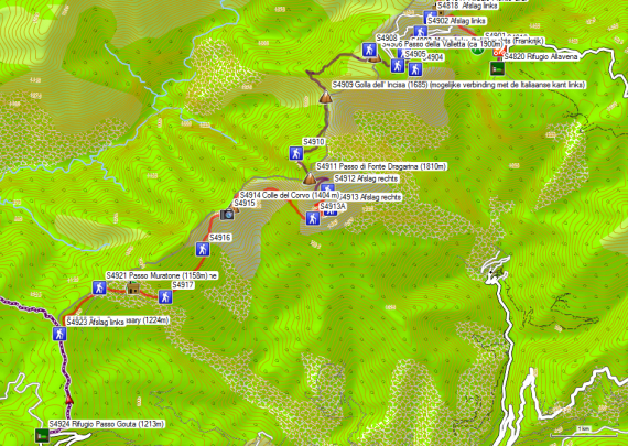
 Note: If you are short of time, you can consider combining stages 47 and 48 into one day’s stage in good weather conditions.
You return from yesterday’s direction, but keep following the gravel road until the first hairpin bend. Here you leave the road for the beginning of the Sentiero degli Alpini. At the beginning of the path (GPS S4902), there is an info sign of the CAI, which is a copy of the sign hanging at the exit in the Rifugio Allavena. However, both the approach route and the first part of the route on the Italian side are indicated as dangerous here. This concerns the risk of chipping and a “high technical difficulty” of the path.
As far as the approach route is concerned, this risk of falling stones is mainly caused by the presence of sheep on the higher part of the slope. These animals can accidentally knock down stones that can then end up on the path. The technical difficulty does not exceed certain items mentioned earlier in this report as being fused with steel cables. In wet weather, this route is less recommended.
You can avoid this approach route by following the gravel road until you reach the third hairpin bend, where you come close to the path (GPS S4905) that leads to the Passo della Valletta (ca 1900m) (GPS S4906) (French side).
From the beginning of the Sentiero degli Alpini (GPS S4902), you climb to the junction (GPS S4903) between the Italian variant (left, dangerous, see above) and the French variant (right). If you follow the French version, you miss the passage (Italian version) of which you can see a picture in the Rother guide (p247), where you walk in a carved passage in the rock face. Because the weather conditions were good and Rother explored the Italian side, the safer French side was chosen for this report.
Initially, the path climbs up to a saddle, where there is an old signpost indicating a Via Ferrata, which according to the owner of the Rifugio Allavena has been closed for 5 years. In the Rifugio Gola di Gouta they have an old photo book about this Via Ferrata on the Sentiero degli Alpini. The biggest problem with this Via Ferrata was that you had to descend it with the help of a brought along mountain rope and the associated descending equipment, which is not customary anymore.
At a ruin in an open area (GPS S4904) you make a hairpin bend and climb through the forest towards the third hairpin bend in the gravel road. At a kind of T-junction at a drinking trough (GPS S4905), turn left (right gravel road). After a horizontal part, you take another hairpin bend and climb towards the pass. You end up on a wide road (GPS S4906) and follow it straight ahead towards a second signpost (GPS S4907). Do not turn left in the direction of Monte Pietravecchia but turn right in the direction of Gola Incisa. This road makes a bend to the left in a descending direction and you pass a mile marker of the Alta Via (GPS S4908). From here on, the orientation is easy, as the AV is usually well marked. You follow a path without big differences in altitude towards Golla dell’ Incisa (1685m) (GPS S4909), a real incision in the rock, where you can make an easy connection with the Italian side (turn left).
If you prefer the French side, continue straight on and slowly climb an offshoot of Monte Toraggio (GPS S4910) and from there descend towards Passo di Fonte Dragarina (1810m)
(GPS S4911). Via this pass, you return to the Italian side and descend in a zigzag through an ungrazed alpine pasture, until the meeting point with the Italian variant nearby (GPS S4912). From here on, you are back on the by Rother described route via the Italian side. You descend further into the flank and then turn into a traverse in the direction of Colle del Corvo (GPS S4914). Again you can choose a variant (right) via the Col Sandérau along the French side up to the Passo Muratone (1158m) (GPS S4920) (indicated in grey dotted line on the map in the Rother guide). This variant was not logged.
Shortly after the Colle del Corvo (GPS S4914), the path along the Italian side goes up a little to GPS S4915, then slowly descends towards Rifugio Muratone (GPS S4919).
Rifugio Muratone (GPS S4919).
It is locked up. Property of Comune di Pigna
Tel: +39/0184/241016
Beautiful location with picnic tables in the shade.
From the Rifugio Muratone (GPS S4919) the path goes slightly uphill towards Passo Muratone (1158m) (GPS S4920). From the Passo Muratone, the route continues on a slightly undulating course towards the Colle Scarassary (1224m) (GPS S4922). It continues in almost horizontal terrain via a wide road between cottages, further towards Rifugio Passo Gouta (1213m) (GPS S4924).
Walking time without rest: 4h30′, with rest: 4h45′
1.0L of water
Rifugio Passo Gouta (1213m): (Gesloten sinds 01/10/2023)
Language: Italian,
Tel: +39/0184/241068
+39/335/5393560
Dag 49V C Melosa – Rocchetta Nervina 24.7km +937m -2262m


Referring to the above-mentioned closure of the strategically located overnight accommodation point: Rifugio Passo Gouta (1213m): (Closed since 01/10/2023), one will have to come to the conclusion that an adjustment and combination of the described stages 48 and 49 becomes necessary. Anyone who has been on the trail for some time and is in good condition will experience few problems. In practice, 3 stages are reduced to 2.
For the start of the description between Colle Melosa and Golla dell’ Incisa (1685m) (GPS S4909), we refer to the aforementioned stage. The Golla dell’ Incisa is a real incision in the rock, where you can easily switch to the Italian side (turn left). To reduce the difficulty and length of the stage, this is recommended.
You follow the Italian variant until you reach the path that descends from the Passo di Fonte Dragarina (1810m) (waypoint S4911) at (waypoint S4912). From here both variants are back together and you follow the route described by Rother via the Italian side. You descend further into the flank and then turn into a traverse towards Colle del Corvo (GPS S4914). Here too you can opt for a variant (right) via the Col Sandérau along the French side to the Passo Muratone (1158m) (GPS S4920) (indicated in a gray dotted line on the map in the Rother guide). This variant was not logged.
Shortly after the Colle del Corvo (GPS S4914), the path goes up a little along the Italian side to waypoint S4915, and from there it descends slowly towards Rifugio Muratone (GPS S4919).
Rifugio Muratone (GPS S4919).
It is locked up. Property of Comune di Pigna
Tel: +39/0184/241016
Beautiful location with picnic tables in the shade.
From the Rifugio Muratone (GPS S4919) the path goes slightly uphill towards Passo Muratone (1158m) (GPS S4920). From the Passo Muratone, the route continues on a slightly undulating course towards the Colle Scarassary (1224m) (GPS S4922). It continues in almost horizontal terrain via a wide road between cottages, further towards Rifugio Passo Gouta (1213m) (GPS S4924).
Walking time without rest: 4h30′, with rest: 4h45′
1.0L of water
Rifugio Passo Gouta (1213m): (Closed since 01/10/2023)
Language: Italian,
Tel: +39/0184/241068
+39/335/5393560
Open: all year round, normally closed on Thursdays, but if you call from the Rifugio Allavena, you are also welcome on Thursdays. Was run by an older couple.
Given this closure, do not return to the Colle Scarassary (1224m) (GPS S4922), but follow the SP69 road to the left in a southerly direction. At the first hairpin bend you leave this road in a southerly direction via a path. After 200m you ignore a path to the left. After another 250m you reach a number of buildings in line along the road. Another 250m after the last building you ignore another path to the left. The path now turns west. After 400m you reach 2 more buildings.
After 400m you reach a highest point (Monta Commune (1240m). You start the descent, and after 400m you leave the road, which continues to a dead end, to the left via a path that descends further via the grade. At the Passo di Loggia (1011m), leave the grade to the right. You enter the pine forest and descend further in zigzags until you join a path from the right that crossed the Torrente Barbeira.
You leave the forest, after which another path joins your path from the right. You descend further along the same bank of the Torrente Barbeira. Just before Rocchetta Nervina, you pass through a section of plantation. You continue walking on the same bank until you reach the Osteria B&B La Pecora Nera.
Osteria B&B La Pecora Nera (GPS S5031):
Via degli Ulivi 18
18030 Rocchetta Nervina (IM)
WhatsApp/Cell. 0039 345.4690888
Prices: starting at 87€ (2024)
Just outside the village, you’ll find:
Ostello della Alpi Liguri (GPS S5033):
Via Rimenbranza 38, Rocchetta Nervina, Italy
+39 320 8594 957
ostello.rocchettanervina@gmail.com
Room: 35€ (2022)
Bed in a dorm room: 14 tot 17,5€
Hotel Lago Bin (GPS S5034):
18030 – Rocchetta Nervina (IM)
Liguria, Italy
lagobin@lagobin.it
+39 0184.207108
Prices: starting at 86€ (2024)
Day 50 Gola di Gouta – Alta Via 20.6km +544m 1159m

 The normal daytime schedule is rather short. Those who are not in a hurry can explore the ridge route that was logged for this report.
Return to Colle Scarassary (1224m) (GPS S4922). Here you follow the road that makes a bend to the left.
If you walk here on a Saturday, mid-September, you are almost run over by all the French and Italian border residents, who, despite all the prohibition signs, come to pick mushrooms in the woods at the border level. With every possible type of vehicle, they drive up the mountain, from old cars to SUVs. Low suspended sports cars are not recommended because of the many potholes in the road surface, consisting of gravel and soil.
At the first junction with a signpost (Margheria Gion 1320m), go straight ahead. At the second fork with a signpost, turn left towards L’Arpette, Collet d’Aine & Breil-sur-Roya, and Mountain bike route 1. Further on you reach the border of the Park National Testa Alpe. From here there are no more mushroom pickers to be seen :-).
From here there is a rather long, but slow climb to an opening in the forest, where you will find a signpost again. Here, you go straight on towards Pas de Sausson, Roche Fourquin & Hameau de Libre. A little further you reach the highest point. Shortly after this highest point (GPS S5008), you reach a signpost (GPS S5010), where the AV leaves the gravel road for a path that descends into the flank. This part is quite long; eventually, you pass an old military structure and the path turns into a road. A little further on, you pass a source (Fontana Povera 1185m), and it hasn’t stolen its name. At the end of the season, there is little water coming out.
Between (GPS S5014) and (GPS S5015) the path splits into two parallel tracks that come together again. On the Colla Sgora (1063m) (GPS S5016) turn left at the signpost towards Ventimiglia. A bit lower in the descend, there is a kind of Y-junction, where you keep to the left in the major road. At GPS S5018 you can reach the gravel road and also the main Rother track, a bit lower. This is where you turn right. Along this road, many blackberries are to be found in mid-September. You can really eat yourself sick.
You descend via 4 hairpin bends and then the road makes a right angle bend just in front of a col. Here you leave the road Turn right (no indication) (GPS S5020) for an initially unmarked path, which also starts to become overgrown, as it is probably underused. If you don’t like this, you can continue on the slightly longer road. Near the saddle (GPS S5021) that you cross here, the Rother tracklog is not very accurate. You descend along a path, where a black rubber water tube runs above ground next to the path. You reach the Bassa d’Abellio (750m) (GPS S5023), where you descend to the left back to the gravel road you reach at GPS S5025. Here you turn right.
Walking time without rest: 5h15′, with rest: 5h45′ (via the ridge, which is a variant of Rother) 1.0L of water
Rifugio Alta Via (528m):
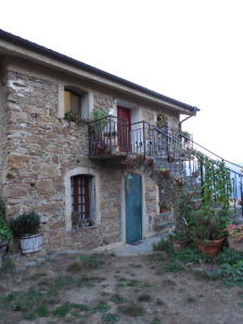 Only known on Google maps. All other sites, except for the Italian Touringclub, refer to the agriturismo and winemaker B&B Alta Via, situated lower in the valley, a little past the Agriturismo le Terre Bianche, indicated along the trail
Azienda Agrituristica Rifugio Alta Via, 500 m, I-18035 Dolceaqua, Località Pozzuolo, Strada Militare La Colla – Gouta, 8 Beds and a small camping place, restaurant and shower.
No email address known.
Only contactable by phone.
Language: Italian,
Tel: +390184206754
+393471148174
+393482973505
H/P: (alone in a room) (no information to be found online)
1/4L Red wine: included
Shower: included
Dinner 19:30hrs.
0°: anti-paste: quiche
1°: pasta with tomato and zucchini
2°: chicken with lettuce and tomato and zucchini
3°: fruit
Breakfast (7:30 AM): Typical Italian breakfast: (dry) bread, toast, jam, butter. Coffee or (green) tea and plenty of fruit.
Day 50V Rocchetta Nervina – Ventimiglia 16.4km +834m -1047m

You cross the river and leave Rochetta Nervina. You will successively pass the Ostello della Alpi Liguri (GPS S5033) and the Hotel Lago Bin (GPS S5034).
After just under 2km the SP68 makes an S-bend, after which you reach a crossroads. Here you turn right into the Strada degli Olandesi. After about 3 km you reach the Aria Fina restaurant (S5107A). You go to the right here.
After 1.5 km you reach the SP69, which crosses you. You continue via the SP92. In the second right-angled bend you turn left into a gravel road. Here, at waypoint S5108, you again reach the Alta Via dei Monti Liguri and the route of the Rother guide, which you follow to the left.
We refer to the last stage for a further description of the route.
800m along the path you will find signs to S5110:
Agriturismo le Terre Bianche (GPS S5110A),
+39 320.8904988
Via Pastorie, 23 , 35037 Teolo (PD)
with the lure of a refreshing glass. However, you have only just finished your breakfast and so you do not investigate whether the advertising is in accordance with reality ;-).
At GPS S5111 the Rother tracklog follows a narrow, partly overgrown path along a fence. It is not immediately clear what the added value of this choice is. The mountainbike trail continues to follow the road and the Rother tracklog also returns to this at the second GPS point.
So here you turn left and you arrive at a small pass, which is quite busy during the weekend. You cross the road and continue straight ahead. You pass the Piramidi Di Gesso (GPS S5114A), a photogenic erosion area. A little further on you are sent diagonally left up the mountainside, via a path that is marked, but deviates from the Rother Tracklog. It is not entirely clear whether this has to do with the condition of the road and any erosion risk of the Piramidi Di Gesso. The fact is that at GPS S5119 you return to the road, which you continue to follow along the side of the slope.
At GPS S5120 you leave the road for a path and just before the Madonna Della Neve, you return to a better road. The chapel itself is a big disappointment from the outside.
The Rother tracklog follows the asphalt here to GPS S5126. The markings on the site follow a narrow path parallel to the road along the backside of the houses.
At GPS S5126 you cross or leave the asphalt for an initially narrow path over the mountain ridge. At GPS S5128 keep left. You go around the Monte Delle Fontane (475m) (GPS S5128A) and descend with a view of the sea.
At a junction (waypoint S5129) keep left and take the descending road. At the next junction (waypoint S5130) cross the river and keep left again.
At GPS S5131, you continue straight ahead at a fig tree. You leave the road just before the SP69. The gravel road leads to asphalt near a number of beautiful houses, with a few dull ones in between. At GPS S5132 you will find indications that the road straight ahead is a private road. This is indeed the AVLM’s trajectory.
 Here you descend through prickly Mediterranean vegetation. You finally get a view on Ventimiglia and then you descend in zigzag, through a bit more open terrain. With GPS S5135 you reach the asphalt. You follow this in descending direction to the right. In a bend to the right, the Via San Giacomo joins the road from the left. You descend further towards the railroad, which you cross via the bridge. Cross the bridge and turn right at the exit of the parking of the station to the left and take the Via Chiappori. At the end of this road, you’ll find a take-away pizzeria on your left. Follow Via Chiappori to the seaside. A little to the left you will find a water tap here, where you can possibly replenish your water supply (for those who are price-conscious :-)).
 You’ll find here on the right in the Passeggiata Oberdan the usual dike restaurants, all with a similar menu and prices. Here you go to the right to reach the public (pebble) beach of Ventimiglia, for the ritual washing of your feet. Hopefully, you will think things over, before you jump into the saltwater with your good mountain boots on, just like Dieter Haas (picture Rother p233).
Day 50 Alta Via – Ventimiglia 12.6km +336m -835m

 You leave the terrain of the Rifugio Alta Via and follow the asphalt in a southerly direction over a distance of about 800m. Here you go sharply to the right and after a short climb, you turn left at the intersection. Before the Cima Tramontina (551m) (GPS S 5105A) with transmitter mast, turn right. You come at a T-junction, where you go to the right and a little further you go to the left, to cut short the hairpin bend and then cross the same road again to continue in the direction you took. You keep following the same direction for a long time, parallel to the SP69. In the narrower parts, the road is sometimes partially overgrown with thorny Mediterranean shrubs. On the path, you will find signs to S5110A Agriturismo le Terre Bianche (GPS S5110A), with the lure of a refreshing glass. Only you’ve only just finished your breakfast, so you’re not going to investigate whether the advertising is also in line with reality ;-). At GPS S5111 the Rother tracklog follows a narrow, partly overgrown path along a fence. The added value of this choice is not immediately clear. The VTT continues to follow the road and the Rother tracklog returns to the same road at the second next GPS point.
Here you go to the left and you end up on a small pass, which is quite busy at the weekend.
You cross the road and continue straight ahead. You pass the Pyramids Di Gesso (GPS S5114A), a photogenic erosion area. A little further you will be sent diagonally left on the mountain slope, via a path that is marked but deviates from the Rother Tracklog. Whether this has to do with the state of the road and possible erosion risk of the Pyramidi Di Gesso, is not entirely clear. The fact is that with GPS S5119 you return to the road, which you follow further in the slope. At GPS S5120 you leave the road for a path and just before the Madonna Della Neve, you arrive on a better road. The chapel itself is a big disappointment from the outside. The Rother tracklog follows the asphalt to GPS S5126. The markings on the terrain follow a narrow path parallel to the road along the back of the houses.
At GPS S5126 you cross or leave the asphalt for an initially narrow path over the ridge. At GPS S5128 keep to the left. You round off the Monte Delle Fontane (475m) (GPS S5128A) and descend with a view of the sea. At a junction (GPS S5129) keep left and take the descending road. At the next junction (GPS S5130) you cross the riverbed and keep to the left again.
At GPS S5131 you go straight on to a fig tree. So you leave the road just before the SP69. The gravel road gives access to asphalt near a number of beautiful houses, with a few less beautifully unfinished ones in between. At GPS S5132 you will find indications that the road straight ahead is indicated to be a private road. This is indeed the trajectory of the AVLM. So you continue straight on and 500m further you reach the end of the ridge and finally, you start the descent to the sea. At a “construction site,” the road makes a bend to the left and then ends on a path near a signpost of the AVLM (Km 2).
Here you descend through prickly Mediterranean vegetation. You finally get a view on Ventimiglia and then you descend in zigzag, through a bit more open terrain. With GPS S5135 you reach the asphalt. You follow this in descending direction to the right. In a bend to the right, the Via San Giacomo joins the road from the left. You descend further towards the railroad, which you cross via the bridge. Cross the bridge and turn right at the exit of the parking of the station to the left and take the Via Chiappori. At the end of this road, you’ll find a take-away pizzeria on your left. Follow Via Chiappori to the seaside. A little to the left you will find a water tap here, where you can possibly replenish your water supply (for those who are price-conscious :-)).
You’ll find here on the right in the Passeggiata Oberdan the usual dike restaurants, all with a similar menu and prices. Here you go to the right to reach the public (pebble) beach of Ventimiglia, for the ritual washing of your feet. Hopefully, you will think things over, before you jump into the saltwater with your good mountain boots on, just like Dieter Haas (picture Rother p233).
Ventimiglia:
The number of overnight stays in Ventimiglia is limited and therefore they are pricey. Those who do not return by plane via Milan should try to find refuge in Menton, where the choice of Internet-accessible hotels (www.booking.com) is greater.
Via de Via Della Repubblica en de Via Della Stazione, you reach the Station of Ventimiglia. Don’t look in vain at the vending machines to buy a ticket to Menton, because despite the fact that Menton is so close, it’s impossible. So brave the long line of people waiting in front of the counter with service; with some luck, after 10′ you can buy a one-way ticket to Menton Gare. Don’t forget to validate your ticket in white with green oval-shaped validation machines for train tickets.
Don’t get off at Menton Garavan, but at the next station of Menton-Gare (main station). Leave the station to the left and descend the Avenue de la Gare until about halfway, where you will find the Hotel Restaurant de Belgique.
Walking time without rest: 3h30′ (no rest)
1.0L of water
Hotel Restaurant de Belgique (Sea level):
Language: French
Tel: +33/493357266
Open: all year round (reception 07.30 to 14.30 and 17.00 to 23.30)
Room: 112€ (room with shared bathroom, 0,50€ tourist tax)
Cheaper alternativs via www.booking.com
Menu (starter, main course, dessert) (in the afternoon and in the evening, except on Sundays): 16,50€.
1/4L Red wine: 4€
Breakfast: 6€ (Typical French, the quantity for tourists, but not for mountain hikers, but you have to diminish ;-))
Room 20: night-time noise of a circulation pump every 90′ ca 5′.
Return trip: For the return journey I have three different tickets for the different parts of the journey: Menton – Nice, Nice – Brussels, Brussels – Ghent.
The Menton-Nice ticket is one of the types, without reserved seats, so you can use it at any time of your choice, even if it mentions one hour. Don’t forget to validate your ticket in the yellow validation machines. Fortunately, these are more noticeable than their Italian counterparts.
The Nice – Brussels ticket does have reserved seats. So be on time. The train is also very long and the part towards Brussels is in front. The two parts are only split Lille. Up to Marseille, the train only drives as fast as a normal coastal train, but with a little less stops. In Marseille, the train changes direction. Only after Avignon the train really reaches TGV speed. Around Paris, there are stops at the airport as well as at Eurodisney. From here on, the train picks up speed again until Lille. Here, too, the train changes direction and Belgian personnel come on board to check the tickets. Eventually, the train arrived in Brussels with a delay of 45′. The ticket for the Brussels-Ghent route is also one of the types without reserved seats, so you jump on the first best train to Ghent, where you arrive around midnight and on a Sunday evening you can forget about public transport L.
Final conclusion:
After 3 weeks my goal is reached, and I have to return home. My condition is optimal. I’ve had virtually no trouble. I had to improvise as well as I didn’t. I have conquered some 25,000 meters of altitude and have had almost no rain or thunderstorms during the walks themselves.
I recommend the use of GPS in Italy because you can never be sure of the quality of the markings and signposts on the terrain. Generally speaking, the quality of signposting or marking is better than in certain parts of the northern part. It is therefore not absolutely necessary, but it does save time, energy and frustration. I’m old enough to be able to do without it, but the technology exists, so I don’t see why you shouldn’t use it. I’m not constantly looking at my GPS. I only use it if the markings on the terrain are insufficient.
In addition to self-knowledge, this trip requires a wealth of skills. This is about walking technology on all types of terrain, including sheet metal, loose gravel and to a limited extent snow. A little elementary climbing technique wouldn’t hurt either. In general, the technical level of the most difficult parts is lower than in the northern part and therefore less technical shoes (Lowa Renegade A/B) can be considered for this part.
In addition, you must have basic knowledge of meteorology and be flexible in your plans. Adjust your travel plans according to the weather, your physical condition, and your skills. Self- overestimation leads to accidents. Go into the mountains, but come back (alive!).
