Travelogue HRP East
Randonée Haute Pyrenees – Pyrenean Haute Route (Bagnères de Luchon – Banyuls sur Mer).
The most recent version of this page can be found at https://roversmountains.com/hrp-english/ !

Countries: Sometimes literally on the border of France and Spain
Region: Pyrenees, Aragon, Ariège, Catalunya, Oriental Pyrenees
Range: Bagnères de Luchon – Banyuls sur Mer
Period: 4th September 2015 until 28th September 2015 (Updated 2024)
Travelling companions: Together with the Australian, with whom I finished most of the eastern half of the HRP. Besides him being good company, I was also more assured of my resupplyment, then this was the case by using ‘Post Restante’, which I used on the western half.
Public transportation:
To:
- Ghent – Brussels South (standard rate)
- Brussels South – Paris and Paris – Bagnères de Luchon
- Paris metro line 5 to Gare d’Austerlitz
From:
- Banyuls sur Mer – Paris and Paris – Brussels South (- € 63.80 provided for the delay last year, and this through coupons, which were valid for one year on a return trip)
- Paris metro line 5 to Gare du Nord.
Accomodations:
- Huts owned by the CAF (Club Alpine Français) (cheaper as a member of a mountain sports organization).
- Gite d’etapes of hotels elsewhere.
- The unmanned hut at Eric Pujol, Combs de Jan and the free cabin if Ull de Ter is not open, have a well, the water of which should be boiled, filtered or treated with Micropur before use.
Payment methods:
- Cash
- Electronic payments in the hotels is possible.
- Bancontact (ATM) (note: only available in Luchon, Salardu, Arinsal, Hospitalet pres d’Andorra, Super Bolquère, Arles sur Tech en Banyuls sur Mer))
- Visa (accepted easier in France than elsewhere, but do not count on it)
Travel Literature:
At the moment that I started planning this trip, in Belgium merely the Cicerone guide Pyrenean Haute Route Ton Joosten www.cicerone.co.uk (2009, reprinted in 2012 with updates, in English of course) was available. This guide contains approximately 500 GPS points (in UTM format, given the Spanish cards Rando Editions contain a UTM grid).
This English guide was replaced in 2019 by a new edition of the guide by Tom Martens
Mail with Ton Joosten asking whether he had available the relevant points in a digital file, taught me that he did not want to disclose it. He said he had not, but that is totally implausible 😦.
In France, I found that the last edition of the original Haut Randonée Pyrénéenne by George Veron (deceased 2005) and Jerome Bonneux ISBN 978.2.84182.315.4 (2007) www.editions-sudouest.com was there yet. This guide contains more maps and a slightly more detailed description than that of Ton Joosten, but certainly no GPS points.
Jerome Bonneux made himself a guide that describes the HRP from the Mediterranean to the Atlantic, called Trans PYR (2012 www.editions-montrouch.com ), but Google had problems with this site.
In 2025 a new guide was published in French by Marie Millet, which is more recent but might be a problem for English speakers.
Survey maps:
Only the drawn maps in the guidebook and free digital cards from Freizeitkarte-osm.de, in the Garmin GPSMAP device. This unit can Tracklog saving 10,000 points. It weighs 200g with battery and uses 2 AA batteries every three days if you don’t log your track. 8 AA batteries weighing around 200 grams will last about 12 days, if you don’t log.
For the Pyreneans as a whole, there are cards available from Rando Editions (1 / 50,000) of which you definitely need 8 to 10 at 100gr a piece or French IGN (1 / 25,000). The cards in 1 / 50,000 scale are not sufficiently detailed enough for orientation on paths without proper markings.
Internet:
www.ffcam.fr (Club Alpine Français)
www.agrepy.org (Association de Gardiens the Refuges des Pyrenees)
www.alberguesyrefugiosdearagon.com (reservations in Aragon, Spain)
www.wiki.openstreetmap.org/wiki/hrp (track logs)
Personal information:
Pyrenean Haute Route (Hendaye – Bagnères de Luchon).
Introduction:
Where Munich – Venice takes you 3 weeks in alpine terrain and one week of “flat land” with a total altitude difference of approximately 25 000 altimeters and E5 Oberstdorf -Verona (Dutch version only) is hammered at approximately 21,000 altimeters, just for the western part of the HRP (Bagnères de Luchon – Banyuls sur Mer) described in this travelogue you need to overcome 25 000 altimeters in 23 days. Briefly, this means more than 1000 altimeters up and down per day.
That is a lot. This is very much. So, it comes down to knowing what the limits of your body are and not exceeding them.
So it’s important to keep not only your own body weight, but also your backpack weight to a minimum. Also you need to know your gear: good shoes and especially a pair of hiking poles are essential. And for those who start early in the season: an ice axe and crampons.
Physical preparation:
The better your physical condition is at the start, the greater the chance will be that you can enjoy your trip. The older I get the more I become convinced of the need for a good physical preparation. Walking in the rolling country is good, but the feel of a climb 2500m in combination with a descent of 1000m you can never match. In 2007, I lost 10kg, for the simple reason that not only every kilo of equipment that you carry bears weighs, but also every kilogram of overweight. And so I brought my BMI to a level below 25 and there it will remain from now on.
Equipment and supplies:
Clothing on the body:
- a pair of approach schoes type A (The North Face Hedgehog)
- Shoes: boots of the type B or C (La Sportiva Evo Trek – Löwa Alpine Evo GTX of Cadin II GTX Mid) preferably from a known brand and preferably in combination with a layer of Gore-tex. As an alternative mountain shoes of the A/B type (Lowa Renegade Mid), can be used if you start late in the season, when there is a low chance of having to use crampons or an ice axe.
- Set of socks: preferably 2 of good quality (loop fabrics on the inside and ranging in materials from wool to Coolmax)
- Summer climbing pants (Mammut Schoeller Dryskin) or a cheaper alternative from Decathlon.
- Synthetic underwear: briefs (my preference goes to the microfiber ones by Nur Die) and T-shirt with long or short sleeves (for sale at Decathlon or the classic outdoor sports shops)
- Lightweight fleece
- Sun hat (Decathlon)
Clothes in your backpack:
- Gore-Tex jacket with hood or rain hat (Outdoor Research). (Gore-Tex still enjoys my preference, but those who are deterred by the high purchase price, may find reasonable alternatives at the Decathlon store)
- Sunglasses with high filtration rate, sunscreen (SPF 20 or higher) and possibly lip balm with sun protection)
- Replacement synthetic T-shirt and slip
- Set of spare socks
- Set of spare clothing (shorts with your spare T-shirt) to wear in the cabin and cabin slippers. In most lodges you can’t enter in your hiking boots, but the floor isn’t sufficiently even, to just walk around wearing only socks.
Other equipment:
- Telescopic walking poles (relieves the pressure on the knees, when descending). It is advisable to buy poles of well known brands: Leki or Decathlon, as a cheaper alternative. Even cheaper are Naturehike poles bought on AliExpress. Pay attention to the material of the handles (no hard plastic) and eschew particularly sticks with a buckle in the hand strap. Prolonged use will irritate your hands at the buckle.
- Backpack of 45+10l.van Lowe Alpine, which is lighter than my previous model from Decathlon. Despite the fact that the backpack comes with a rain cover, I always put everything in plastic bags closed with a metal clip. Small gear and daily rations go into freezer bags from Aldi.
- A sleeping bag with a comfort temperature of 0 to -5 ° C. Even cabin hikers should bring a decent sleeping bag, since you run the risk of having to sleep in a Decathlon 2″ tent type, if the cabin is full, due to a large influx of lodge hikers. Also bring along a light plastic sheet the size of a sleeping mat, since not everything is as clean as it should be in those tents. You shouldn’t bring a Thermarest, because it is available in the rental tent.
- 1 towel 50 x 30 cm, preferably in micro fiber (dries faster and carries less odor, when not dried properly.)
- 1 small bottle with a shower soap and shampoo, a washcloth, a small travel toothbrush with toothpaste (you can also save an almost empty tube for travel), a stick of shaving soap and disposable razor blades or an electric travel shaver on batteries.
- A few packets of paper handkerchiefs, does double duty as toilet paper.
- A Camelbak preferably with a total capacity of 2 to 3 liters (see trip descriptions for sources along the way.) Don’t know whether I like the new models with the zipper closure.
- Opinel knife or Swiss Army knife
- Micro Headlamp (Petzl Tikka Plus 2).
- Personal pharmacy: bandages, sterile gauze, antiseptic, wound plasters, scissors, sports tape, Compeed, ibuprofen, paracetamol, Rinomar (for runny nose) Immodium (generic: Loperamide for diarrhea).
- Spare plastic bags
- Needle and thread
- GSM (network coverage not assured) or GPS with combined satellite phone for those who can or are willing to pay for it.
Other equipment specific for users of unstaffed huts:
- Down bag (The North Face Gold Kazoo – 2° comfort – 800gr)
- Waterproof compression bag (Sea to Summit, Large) to protect the sleeping bag, given that I wore out on the outside of the backpack, because of its size (28 €).
- NeoAir UberLite Sleeping Pad (250gr – R-value: 2,3 – (51 x 183 x 6,4cm – 220€) NeoAir XLite NXT Sleeping Pad (370gr – R-value: 4,5 – (51 x 183 x 7,6cm – 204€) Or Budget friendly: Decathlon (510gr – R-value: 1,5. (60 x 195 x 5,0cm – 50€). Ideal for temperatures above 8°C. (norm ASTM F3340-18).
- In terms of fuel, I still prefer alcohol, but I have now switched from a 25 year old Trangia to a more modern Esbit CS985HA (430gr) (esbit.de) (www.campz.be) without a flame distributor, pocket rocket type. It is faster and lighter than the Trangia. Wind screens can be omitted for users of unmanned cabins. The traditional Esbit solid fuel cubes can also be used here instead of alcohol. The mentioned burner is also suitable for this.
- Pocket knife, matches in a film can with the side of the matchbox in it.
Other equipment specific for campers:
- Hilleberg Akto with footprint (1.85 kg)
- Down bag (The North Face Gold Kazoo – 2° comfort – 800gr)
- Waterproof compression bag (Sea to Summit, Large) to protect the sleeping bag, given that I wore out on the outside of the backpack, because of its size (28 €).
- NeoAir UberLite Sleeping Pad (250gr – R-value: 2,3 – (51 x 183 x 6,4cm – 220€) NeoAir XLite NXT Sleeping Pad (370gr – R-value: 4,5 – (51 x 183 x 7,6cm – 204€) Or Budget friendly: Decathlon (510gr – R-value: 1,5. (60 x 195 x 5,0cm – 50€). Ideal for temperatures above 8°C. (norm ASTM F3340-18).
- In terms of fuel, I still prefer alcohol, but I have now switched from a 25 year old Trangia to a more modern Esbit CS985HA (430gr) (esbit.de) (www.campz.be) without a flame distributor, pocket rocket type. It is faster and lighter than the Trangia. Wind screens can be omitted for users of unmanned cabins. For outdoor use, it is best to make 2 wind screens from the side wall of 330ml drinks cans. They weigh nothing and fit perfectly in the burner base. You always buy a gas bottle full and you have to carry it full with you at the start. You can dose alcohol perfectly and pour it into an adapted small plastic bottle. You can no longer find an alcohol burner in regular outdoor sports stores, but only via http://www.campz.be (probably too good, too cheap and not enough spare parts needed ;-)). Methanol (burns purer than the ethanol available in Scandinavia). Furthermore, use a sawn-off plastic spoon. That’s all you need to eat a freeze-dried meal. The argument that alcohol has a low calorific value is theoretically correct, but in practice it is nonsense, since you really don’t need much to heat up a freeze-dried meal: 35ml in the evening for a full portion, 25ml in the morning for half a portion. , use a 50ml syringe (Rohloff oil change kit or pharmacy) with a plastic hose that is sufficiently long for the fuel bottle used.
- Opinel or Swiss Army knife, matches in a film can with the side of the matchbox in it.
- backpack of approx. 80 liters. I still use a 20 year old frame backpack from Bergans, which is still made (bergans.com) . Inside, I still put everything in plastic bags closed with a metal clip. Small items and daily rations go into Aldi freezer bags. For lightweight fanatics with deep pockets, you can also find backpacks from Ula Equipment: starting at €200, available via www.chrispacks.com.
Food:
According to the dietetics, the optimal balance for food contents is: 15% protein, 30% fat and 55% carbohydrate. For certain sports, this mixture should contain even up to 70% carbohydrates.
But keep in mind that fat contains more calories for the same weight of food then carbohydrates.
For this trip, I brought supplies from Belgium for the first 6 days. In reality, this is until Lescun (6 days). Supplies are a relatively big problem in the Pyrenees. The village shops around here are sometimes open on Sunday, but they sometimes have a very limited range of products and so you have to be satisfied with what little is vailable.
Those who really strives for a low backpack weight, should buy a lunch every day at the lodge, hotel or mountain hut, when and if you arrive in time for lunch at the hut, but know that lunchtime food often is the same as in the evening 😦. Or you can buy a take along lunch for long stretches.
I chose for resupply via “Post Restante” (package to be picked up at the post office) both at Lescun and Gavarnie. There were problems with the completeness of the contents of these postal packages. In Lescun the box was resealed, but the contents was complete. In Gavarnie, the contents of the box wasn’t complete. Two daily rations disappeared and a nearly empty bottle of “eau de toilet” was added 😦.
Those who are heavier, will need larger portions.
A menu needs to be sufficiently varied and should of course be acceptable to you.
Know however, that at home I also eat something else than this.
The breakfast at French and Spanish cabins and hotels usually is better than at the Austrian ones. Bear in mind that this means that you eat whatever is available, including cornflakes or other popular cereal and /or biscuits (Spain). If you do this, you have to carry less yourself, and/or buy less supplements to be able to continue until noon. Count on 8€ for a lunch in a hotel or cabin.
Many sports bars already state their composition. If this is not found on the packaging, you will have to use a general list of the composition of different types of food, which can be found in a book about dietetics at the library or on the Internet. If you know that 1g of proteins corresponds with 17 kJ or 4kcal, 1g of fat with 38 kJ or 9 kcal and 1g of carbohydrate with17 kJ or 4 kcal, then you can calculate it yourself.
|
Name: |
Gr.: |
Prot./ 100gr: |
C.hydr/ 100gr: |
Fat/ 100gr: |
Cal/ 100gr: |
KJ/ 100gr: |
Prot %: |
C.hydr %: |
Fat %: |
Total Calories |
|
Muesli Bar |
63 |
5,5 |
77,0 |
9,0 |
418 |
1765 |
3,5 |
48,5 |
5,7 |
263,3 |
|
Energie Bar |
80 |
5,4 |
72,3 |
9,2 |
392 |
1653 |
4,3 |
57,8 |
7,4 |
313,6 |
|
Chocolade with nuts |
40 |
9,2 |
49,7 |
36 |
564 |
2353 |
3,7 |
19,9 |
14,4 |
225,6 |
|
Snickers |
50 |
10,0 |
50,9 |
27,9 |
500 |
2090 |
5,0 |
25,5 |
14,0 |
250,0 |
|
Gingerbread |
40 |
3,2 |
74,0 |
1,0 |
323 |
1371 |
1,3 |
29,6 |
0,4 |
129,2 |
|
Totaal: |
273 |
17,7 |
181,3 |
41,8 |
1181,7 |
|||||
|
%: |
6,5 |
66,4 |
15,3 |
The chocolate is usually from Ritter Sport. Alternatives can be found also at Lidl or Aldi.
Energy Bars can be found at Aldi of Lidl. Foré (fake Snickers) can be found at Aldi. Buy hard muesli bars, not the soft variety, because they crumble easily when being stored in your backpack. Otherwise, you need to keep them in a box which adds extra weight.
Pyrenean cuisine and Mediterranean diet:
If you know that I maintain a diet, low in carbohydrates at home, then you will understand that Italy is truly a culinary ordeal for me. In a low carbohydrates diet, bread, pasta, rice or potatoes, are preferably replaced by higher-value foods like vegetables, fruits and nuts. And let the Mediterranean cuisine be primarily based on refined carbohydrates like bread, pasta and rice. Good for sportsmen, but very bad for those who live a sedentary life.
The lack of raw fruits and vegetables enhances that sense of a culinary poor diet. Pasta, rice and canned vegetables have of course a longer shelf life and are easier to transport than fresh products which is a decisive element for supplying cabins. Most hotels and lodges however lie along an asphalt road, so this is not really an excuse. On the Spanish side, the emphasis is slightly more on vegetables than on the French side. In Spain you can often get a mixed salad as a first course. In France, this often is soup.
Moreover, the timing of the intake of carbohydrates in southern Europe is also poor. The main meal is enjoyed in the evening between 7:00pm and 8:00pm with a surplus of excess calories, which you don’t need at bedtime. Very often the bread at breakfast is the surplus bread of what was the main meal in the evening and it’s quite often dry. Moreover bread spread quite often is limited to sweets. Cheese or meat are real exceptions (only served at certain hotels and lodges, situated along the road). Often you will find very sugary cereals and biscuits, rarely brown bread. Learn to systematically ask for extra bread.
Booking of cabins, hotels and lodges:
For the first two weeks of this trip I didn’t book any accommodation from Belgium, other than the night at Roncevalles, bearing in mind that this is a crossroad with the Camino Francés. For the third week every cabin was reserved by phone and all hotels and lodges were reserved over the internet. For last night at Luchon, I booked a hotel on www.booking.com . If you walk from one CAF hut another CAF hut, the hosts keep in touch with each other and you can ask to reserve the cabin for the next day. But know that the cabins in the Pyrenees are small and that they are crowded during the French and Spanish holiday season (mid-July and August), especially on weekends. With regard to the high-altitude cabins, reservations by mail can only be made just before the start of the season, at the time when the hut guards are still in the valley. For the completeness of the information I state the phone numbers of the huts as listed on the website of the hut or other overnight point (hotel, lodge) or any other source on the Internet. Know that some cabins are not accessible via a normal phone connection, but are only accessible via an intermediate station and a broadcast connection. Know that it is sometimes difficult to make a connection with even normal GSM numbers with a local SIM-card, but if you must make an international connection because you use a SIM-card from your home country, it is even more difficult or impossible. Certain groups of hut can be booked over special website such as www.refusonline.com for huts which are owned by the Spanish FEEC and www.ffcam.fr for huts owned by the French Alpine Club. Cancelations made on these reservations is more difficult because of the reservation fees you have to pay at the time of reservation (10 to15€ a person a night). Also when booking hotels there are sometimes fees charged for cancellations, sometimes depending on the moment of cancellation. Look for cancellation limitations when booking.
Orientation – GPS:
A GPS alone is not of much use. You should feed it with data.
The guide by Ton Joosten gives you around 500 waypoints in UTM format. You will have to feed them yourself into the waypoint. The best way to do this is through Map Source, the old version of Basecamp (Garmin), since in Map Source you can still choose the waypoint format yourself, where this is not the case with Basecamp.
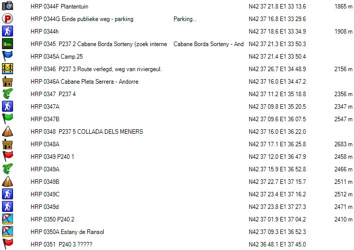
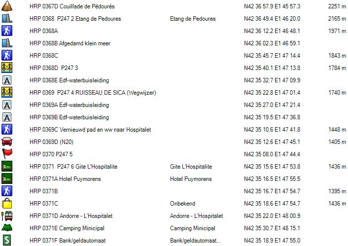
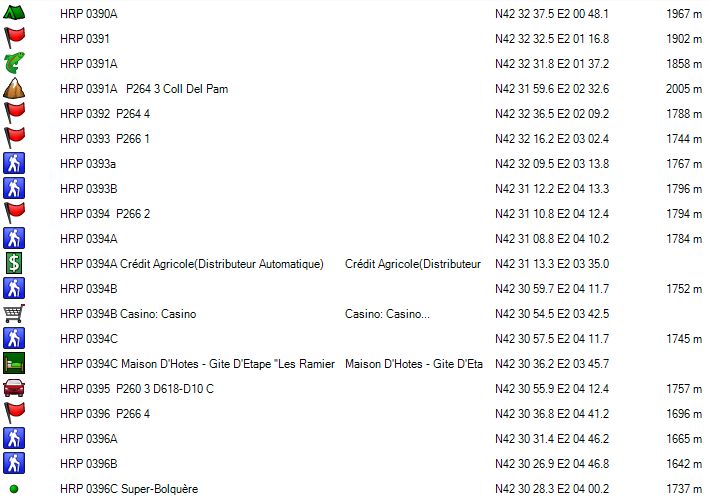
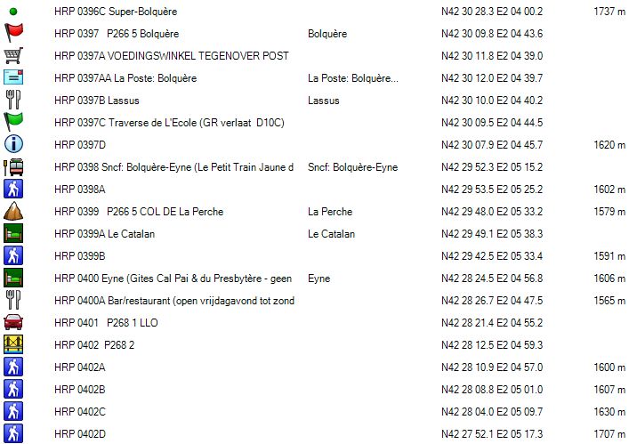
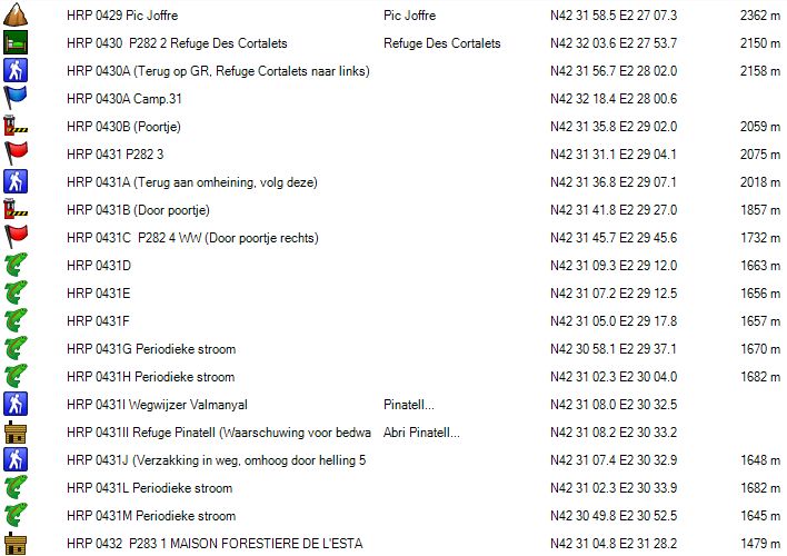
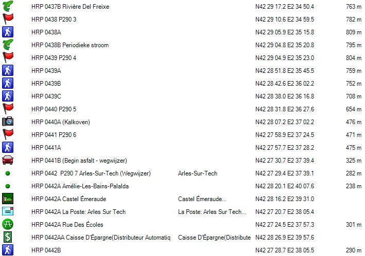
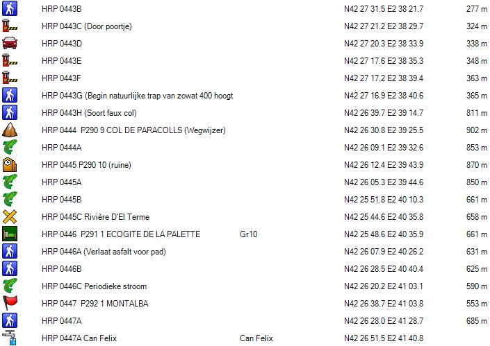
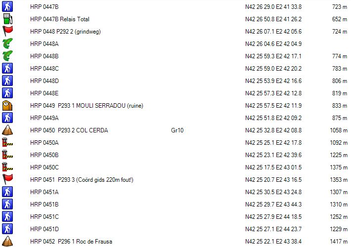
This travelogue refers to these points by a Garmin serial number (HRP XXXX), followed by the page number in the guide and the consecutive number of the waypoint in question on the page in the guide (PXXX Y).
On the internet you can find a track log of the HRP . The track log is relatively little detailed, but you can improve it by using the OSM maps of the Pyrenees which you can upload from the internet. On these maps, you will find almost all trails and by creating a the track log on these trails, you can create a good track log, which you can use on the terrain. You’ll find on the internet also a track log of the GR11 , which is more detailed, but still not to be trusted blindly for direct use on the terrain. So check with the trails on the OSM-maps which are correct most of the time and sufficiently detailed, if you use a 70m interval or less to copy them.
Can you obtain this track log from this site? No. Trying to walk GR20 with a printed report from this site in hand, might be still acceptable, but tackling the HRP in the same way is not justifiable to me, so I will not facilitate this to such a point.
Thus, those who have done their homework, will encounter few problems in the field, in terms of orientation. For those who plan to go early in the season, the path at high altitude sometimes will be determined by snow coverage. And then it comes down to experience and in view of the terrain. Are you capable of descending safely without a decent track until you reach again a part of the path which is uncovered by snow? Where do you cross at best a snow field, which is presumably caved out by a stream running underneath, which can erode the snowfield from below? (Not, if you can avoid it ).
So go en build up experience in the Alps first, where chances of finding a decent track in the snow are bigger, and where the way marks on the ground are better than in the Pyrenees. Also make sure you know how to handle hiking poles, ice axe and crampons before you come out here.
Indicated Altimeters:
The altitude differences specified in the guide by Ton Joosten, do not correspond to reality. Ton Joosten only counts the nominal height differences between the different reference points, but does not take into account in between climbing on site. This is the result of a completely obsolete format of the guide in question, albeit with 500 waypoint-points, but without track logs. Already on the basis of the theoretical track logs that had been made by me as an orientation aid, one simply could conclude that the indicated difference in altimeters is a serious underestimation of the reality on the ground.
For the first day for example Ton Joosten indicates an total 1300 altimeters to be gained, where in really it is 1470m. The descent of 1070m is in reality 1250m. At other stages, this difference is even greater.
Specified waypoints:
The waypoints mentioned in the Cicerone guide are in some cases wrong and this should be approached with caution. Some waypoints are between 80m and 140m away from their actual place on the terrain, and that’s a lot. There are only two possible explanations:
-
Either the points were measured on the card, hence the unusual UTM format.
-
Either the waypoint was turned on and immediately “Mark” was pressed, while the unit was still working to improve the accuracy of its positioning, which can lead to the aforementioned deviations of around 100m.
Choice of direction:
Theoretically, you could walk the HRP from the Atlantic to the Mediterranean and vice versa. Only one guide (Trans PYR (2012 – Jerome Bonneux – www.editions-montrouch.com ), attempted a description in the reverse direction. I personally would not venture me to try to finish the HRP in the east-western direction, because of the dominant wind direction, which is from west to east. You will praise yourself lucky, if you can walk with wind speeds of about 100km / h in your back you rather than in your face.
Access:
Where you can book a plane smoothly a year in advance, this is not possible in case of a TGV. Three months in advance is usually the maximum. How it is possible that the SNCF still doesn’t realize that this is a disadvantage, is still a mystery to me. Furthermore, environmentally friendly rail travel is often more expensive than the plane (depending on destination)
Considering that there is a station at Luchon and Banyuls-sur-Mere, I opted for the round trip by train. Brussels – Luchon (last part by bus from SNCF, for around. Arrival in Luchon at approximately 06.00am. In July and August there is a bus to Hopsice de France from Luchon. Outside this period, you have to take a taxi. If you see other people getting off the bus with backpacks in Luchon, address them. Maybe you can share a cab, if you have the same destination.
Day 22V HOSPICE DE FRANCE – HOSPITAL DE BENASQUE |
10km | +1200 | –700 |
Total without rest: 4:00′ including rest: 5:30’


By bus you arrive at the station of Luchon (HRP 0210L Sncf: Luchon (625m)). In July and August at 09:30am, there is a mini bus leaving towards the Hospice de France from the tourism agency in the center of Luchon. Those who want to leave earlier or outside July and August, will have to take a taxi. Optionally, you can try to share one with other guests arriving with the same bus or train.
The distance by road is over 10km and over 600 altimeters needs to be overcome, with little alternatives off the road to be found.
From 07:00am you can enjoy a breakfast at the Hospice de France. Do not expect much else other than bread, butter, jam, juice and coffee or tea.
Hospice de France (HRP 0210K)
www.hospicedefrance.com yohan.faussurier@hotmail.fr
(+33) 688 324 064
Overnight stay dormitory: 34€ (2024)
Overnight stay 1p room: € 77 (2024)
Limited menu card 😦
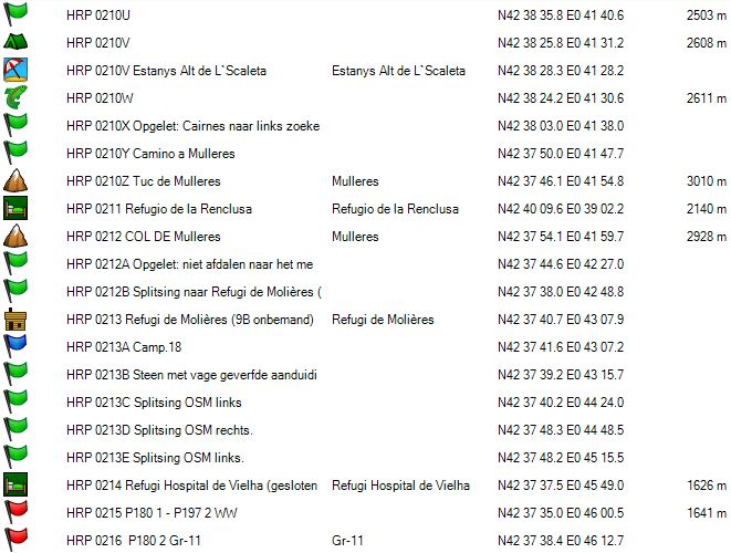
 With your back to the entrance, take the wide path that steeply climbs up against the flank. At waypoint HRP 0210J, you are back on the road that starts at the cabin and climbs slightly slower to the left of the trail. Along the road you continue the climb towards waypoint HRP 0210i, where the road fades and becomes a normal mountain path. You cross the river at the Pont de Penjat (bridge) and continue your way up along the left bank in a zigzag up towards the wading point near waypoint HRP 0210H. At an altitude of 2100m you cross this time one of two arms of the river from the Port de Venasques.
Just before the Refuge de Venasque (HRP 0210F – 20 beds, very busy), you find a signpost painted on a rock. To the left you go to the Port, to the right to the cabin. The direct path to the Port is not very clear. The one along the cabin is clear, but also technically more difficult, with a short climbing passage, where you have to use your hands.
Refuge de Venasque (HRP 0210F – 20 beds, very busy)

(+33) 561 792 646
Overnight fee in the dorm: 12,75€ (2024)
Half board: 29€ + 12,75€ = 41,75€ (2024)
At waypoint HRP 0210D both variants come back together again and continue their way to the PORT DE VENASQUE (HRP 0210C – 2444m – 3h).
50m below the col, you will find a signpost at a junction with very confusing signs. Those who want go to the Refuge de Renclusa continue straight on. Those, who want to go to the Hospital de Benasque turn right here.
The Refuge de Renclusa is booked solid on weekends, especially when the weather is good. And so you are forced to move to the more luxurious but expensive Hospital de Benasque (HRP 0208).
In the bed of the Rio Esera the path is poorly marked and returns to the main path next to the river via a secondary path. In the rising direction, there seems to be no problem.
At the signpost (HRP 0208E), you will find the junction between the paths to the PORT DE VENASQUE (2444m) and the Refuge Renclusa. Further down, you cross the Rio Esera via a bridge. You follow the white-red markers towards the Hospital de Benasque. Here you cross the Rio Esera again over a recently erected tube bridge.
Hospital de Benasque (HRP 0208) (Closed during the summer?):
www.llanosdelhospital.com www.booking.com
(+34) 974 552 012
Haven of luxury in the mountains.
Half-board in a double room: expensive!.
One of the best meals on the HRP 🙂.
Breakfast: phenomenal: really anything you can think of, including bacon and eggs, fresh fruit, cheeses, meats, etc … And in buffet and therefore unlimited. From 7 am including weekends. Served on a serving tray, which you should put on a cart at the end of your meal, which is unacceptable at this price level.
Refuge de Renclusa:
Tel: (+34) 974 344 646
Beds: 92
Prices 2024:
Night: 26,90€ (2024) (Note: hostels in Catalonia do not recognize the membership cards of other mountain sport associations).
Breakfast: € 10.40
Supper: € 21.40
Picnic: € 13.50
Day 23 HOSPITAL DE BENASQUE – REFUGI DE CONANGLES |
21km | +1500 | -1575 |
Total: without rest: 9:30′, including rest: 11:45’ (count on much time for orientation):


 Between the Hospital de Benasque and the Cabane de Besurta, a bus runs several times a day in the summer season. The bus runs in any case at 04:30am, 07:30am and 09:00am and this any day of the week including weekends. This will save you 1:15′ in walking time on an already long day.
 On foot, you return in your steps and walk up to the junction at the signpost at waypoint HRP 0208 E. Here you turn right. The course of the path is quite flat. You can see the bus to the Cabane de Besurta riding along the gravel road to the right of path. At waypoint HRP 0208F, you find a signpost to the PORT DE VENASQUE (HRP 0210C). At waypoint HRP 0208G the path reaches the gravel road, which you follow in an easterly direction until the Abri de la Besurta (HRP 0209). Here the white-red marks go to the right along a path near the river, but you might as well continue to follow the gravel road. Both of them come back together at the Cabane de la Besurta (HRP 0210), a summer bar, open only in the high season. Here ends the gravel road. You’ll find a parking lot and signposts to the Refugio de la Renclusa (HRP 0211).
 At waypoint HRP 0210M you find another signpost with signs to the Refugio de la Renclusa. At HRP 0210n is the path to the Refugio de la Renclusa turns to the right and you should follow the sign towards the Forau D’Aigualluts ( (HRP 0210O). This is a sinkhole of a river. The river goes underground here. In Belgium, this is the case with the Lesse, causing the formation of the caves at Han. At waypoint HRP 0210P the white-red tags of the GR11-5 turn right in the direction of the Refugio de la Renclusa and Barrancs. From here on, you have to follow the sign towards the Coll de Toro.
The path becomes vague and the cairns rather small. This will be the case for the rest of the day. At waypoint HRP 0210Q, you find a bridge along which you cross the river. From here on, begins a difficult passage in the flank along the stream. Here, you follow 3 times the left branch of the OSM track logs. It is constant search for the path and cairns. Further on, you turn into the valley de la Escaleta. This section is flatter. The trail fades and the cairns are too small and too vague for easy orientation, especially in foggy weather.
At waypoint HRP 0210R, you find the split between the path towards the Col de Toro and the one to the Col de Mulleres, indicated by two plates which are screwed on a rock. At waypoint HRP 0210S there is a passage where the course of the path is unclear and you should also use your hands. You cross the outlet of Estanys the L’Scaleta (HRP 0210T). 500m further, just in front of a little lake, you cross the river again.
At waypoint HRP 0210U you follow the right arm of the track log. At the lake Estanys Alt de L`Scaleta, you find a final opportunity to camp on your way to the Col de Mulleres. You’ll find a stream below.
You arrive in a zone with large stone slabs. In this zone, the cairns are clearly visible, because you don’t have to search for them among loose rock. At waypoint HRP 0210X, you need to be very attentive. You need to avoid the cairns toward a broad col to the right of the Pic de Mulleres.
Here, you have search for cairns to the left in the debris field in the direction of the Pic de Mulleres. Barely 200m below the Pic de Mulleres you turn to a saddle to the left of the pic. Looking down from the col, you can clearly see the path, but this is much more difficult, when climbing it!!! Then you need to find a way along the ridge to the Col de Mulleres, indicated by a larger cairn.
 If you look down from the pass, you’ll see a few meters below the ridge, a path which steeply descends through a fine grit field, with some climbing passages along the way down. The first meters below the col, need to climbed down.
It can’t be sufficiently stressed, that the entire section of the HRP between Viados and Vielha should only be undertaken when the winter snow has largely disappeared and even then only in the most optimal conditions. When in doubt, plans should be diverted to the GR10 or GR11. Also stage 26 between Salardu and Refugi Gracia Airoto should only be tackled in the most optimal conditions.
Between the Col de Mulleres and waypoint HRP 0212A, there is a big difference between the path cairned in the field and the track log on the OSM map. Possibly, this track log was made in snowy conditions. Note: at waypoint HRP 0212A you shouldn’t descend towards the lake, but you will need to stay high. The track log is correct until the next fork. At waypoint HRP 0212B being the split with the path towards the Refugi de Molières (not observed on site), there is a large difference between the track log on the OSM-map and the reality on the ground.
At waypoint HRP 0213B, a large stone with vague painted indication of the demerger to the Refugi de Molières, the OSM track log is coincides with the observable situation on the ground.
At a big red stone field, you descend down along the edge of the stone field, to continue underneath it. At HRP 0213C, you follow the left branche of the OSM track log. This is a surprising and technically more difficult section, than you would expect at this altitude. The river plain looks flat, but there was no visible path in this direction. At waypoint HRP 0213E the OSM track log follows the road to the Hospital de Vielha.
Follow the gravel road towards the Refugi Hospital de Vielha (HRP 0214). This is now closed and will remain so presumably, since it is too large to be operated profitably. Walk behind the building and pick up the path to the signpost at HRP 0215 1 P180 – P197 2nd WW. Those who don’t camp, turn to the right here and descends towards the signpost at waypoint HRP 0198 P197 WW 1. Here you cross the river and continue your way through the forest to the Refugi the Conangles ( HRP 0197Z ) .
Refugi de Conangles:
(36 bed – staffed – FEEC ).
Reservations through www.refusonline.com € 15 / ppn
Half-board in dormitory: 52€ (2023)
Possible discount for members mountain sport assosiations.
Many families and regular walkers. Reservation required.
Dinner (08:00pm – Spain):
- Pasta
- Mixed salad with two sausages and bread
- Yogurt
Breakfast ( 7:00am): bread, butter, jam, 1 slice of cheese and one slice of ham, juice, cookies and two slices of cakes (good).
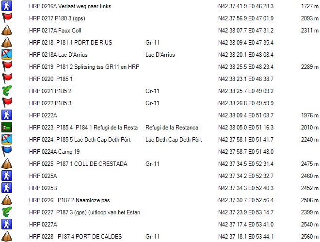
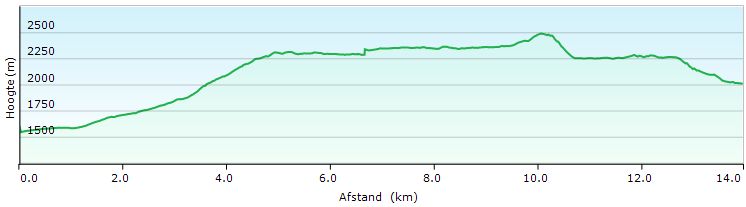
Day 24 REFUGI DE CONANGLES – REFUGI RESTANCA (GR11) |
11,5km | +975 | -575 |
Total: without rest: 4:30′ including rest: 5:30’

Altitude profile HRP24 VIELHA – REF RESTANCA (GR11)
 Altitude profile HRp24 VIELHA – REF RESTANCA (Guide)
After yesterday’s marathon, a day of rest only seems to be justified. For those who strictly want to follow the original version of the HRP by George Vernon, can follow the detour via the lakes Estany, Tort Rius and the Estany de Mar. This extends the stage with 3,5km and adds nearly 200 additional altimeters, both climbing and descending. A stage time of 7:15’ is given, mainly because of the difficult terrain to be coped with, especially the many rocks along the shore of the Estany de Mar (lake).
You’leave the Refug i Conangles to return on your steps towards the Refugi Hospital de Vielha , in particular to the signpost at waypoint HRP 0215 1 P180 – P197 2 WW . Turn right at the signpost. You follow the white-red markings of the GR11 to the Refugi de la Restanca. The trail is somewhat sparsely marked with paint marks, which are completed by cairns, but compared to the previous stage, there are no orientation problems. The OSM track log is very useful. The track log of gr-11completo is very coarse and differs from the reality on the ground.
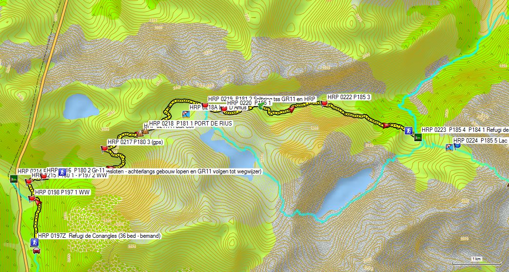
Near waypoint HRP 0216 P180 2 Gr-11, you end up on a gravel road. After a short 400m you leave the road again to the left (HRP 0216A). A bit further you cross a river. A kilometer further you cross another river, which you follow upstream. 400m further you cross the river again. 300m further, at waypoint HRP 0217 3 P180, you reach the fork with the path to the lake Redon. Here, you turn right. From here on, you climb to a kind Faux Col ( HRP 0217A ). Further on, you remain at about the same height, go to the PORT DE RIUS ( HR P 0218 P181 1).
 Descend to the Lac D’Arrius (HRP 0218A), which you then round along the left bank. At the end of the lake, you find the split between the GR11 and the HRP . The GR11 goes straight on. The HRP rounds the lake along the opposite shore, for an extra round of lakes, on your way towards the REFUGI DE LA RESTANCA (for those who can’t get enough of it). But after yesterday’s marathon stage, this seems unwise to me. The ideal survival strategy for the HRP hiker is to reduce both risk and effort.
At waypoint HRP 0220 P185 1 a source can be found. At waypoint HRP 0221 P185 2 a stream can be found and at waypoint HRP 0222 P185 3,you’ll find a path that descends into the valley (Arties). Here, you turn to the right. At the end wall of this valley, the GR11 is difficult to follow between the bushes and boulders. You arrive at a pass, followed by a very steep climb to a pass and the cirque which constrains the Lake Restanca. You climb underneath a powerline along a technical, steep and difficult path. Once up, you cross the foundations of the old hut. Just before the dam, you’ll find a signpost (HRP 0222A), where the variants through the valley start. You cross the dam, to reach the Refugi de la Restanca (80 beds – staffed) (HRP 0223 P185 4 P184 1).
Refugi de la Restanca (80 beds – staffed – FEEC) :
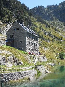
www.refusonline.com Tel (+34) 902 734 164
Rooms available: 5:00pm (backpack and shoes remain at the entrance)
Dinner (7:00pm)
Breakfast (7:00am): bread, butter, jam, white cheese, chocolate, salami, cookies, cakes, juice, coffee, tea. Buffet: so unlimited accompaniments.
(This FEEC hut accepts non-FEEC membership cards while others don’t)
Half board: 63€ (2023)
Half board + Picnic: 77€ (2023)
| Day 2 5 REFUGI RESTANCA – SALARDU | 20 km | +800 | -1500 |
Total: without rest : 7:00′, including rest: 8:00′

 Altitude profile HRP25 REF RESTANCA – SALARDU

Altitude profile HRp25 REF RESTANCA – SABOREDO (French option)
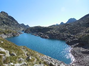
You leave the entrance door of the hut in a straight line, taking the upper path until you arrive at the river. Here, you climb in zigzag along the river towards the dam of the reservoir Lac Deth Cap Deth Port (HRP 0224 P185 5). You cross the dike and follow the right bank of the lake. Then you continue to climb further along the right bank of the river, in the direction of the COLL DE CRESTADA (HRP 0225 P187 1) .
 Ahead you will find multiple exits towards the Refugi Ventosa . Do not pay much attention here at the on the signpost specified times, because they do not make much sense. Continue to climb to a nameless pass (HRP 0226 P187 2). Descend to the outlet of the lake Estany de Sant Maurici (HRP 0227 P187 3 ) to climb to the PORT DE CALDES (HRP 0228 P187 4).
You descend between the two lakes, which you see in the distance. You continue to descend further along the left bank of the feeder river of the Lake Colomèrs towards the lake itself. You pass the access path towards the Refugi de Colomers (HRP 0230).
Refugi de Colomers (60 beds – staffed – FEEC ) 

Half board: 60€ (2023)
Half board + Picnic: 74€ (2023)
Tel (+34)902734164 973641681
You continue down in the direction of the dam, to round the OLD REFUGI DE COLMERS (HRP 0231 P187 6) clockwise. You pass underneath the pedestal of the old hut and you continue towards the dam, which you then cross. On the other side you’ll find a signpost, which indicates the new path alng the right bank and the junction with the French variant, towards the Refugi de Saboredo (HRP 0231A).
If you follow the Cicerone guide, you descend along the wide path on the right bank of the river towards BANHS DE TREDOS (HRP 0236 P188 4). At waypoint HRP 0231B, you return to the left bank across a bridge, followed by a boardwalk over a swampy area. At waypoint HRP 0232 P187 7 you cross another current. From her on, the path is wide and very eroded. From the parking lot below (HRP 0233 P188 1), the Refugi de Colomers is an easy to reach destination, even for those who are not in the best physical shape. From this parking lot on, there is a taxi service in the direction of BANHS DE TREDOS, because this road is closed for private vehicles.
Banhs de Tredos:
Tel (+34) 973 253 003 (expensive, no rates online!)
From the parking lot on, it is wise to follow the gravel road. In the first part, there is also a marked path, but this partly passes through a marshy area and partly goes around it. Then the path shortcuts the hairpin bends of the road to arrive at a picnic area in the woods. Here the trail goes through the forest and follow a course to the left of a marshy area, while the road is doing this along the right. The trail goes up and down a lot and leads you across many bridges. The progress along this trail is slow, so the gravel road is a good alternative. At waypoint HRP 0235 P188 3 both join again and you can choose again between road and path, until you arrive at the public car park at Banhs de Tredos.
At this point, the gravel becomes asphalt. Below in the valley you pass the lake D’Aiguamòg (HRP 0236B). 450m past the lake you will find a signpost where you can leave the asphalt, but you can also continue along the asphalt until the center of Salardu. Choosing the valley road, you cross the river RIO GARONA DERUDA (official HRP – HRP 0238 P188 6) and continue towards the center of Salardu.
In the center of Salardu opposite the car park, you will find a white building with a black roof, being the Refugi Juli Soler Santalo (105 bed – staffed – FEEC) (HRP 0239H P 189 1). Enter the building, along the terrace facing the street.
In the center of Salardu you can also find a small food shop (HRP Shopping 0239I) and an ATM (HRP 0239J)
Refugi Juli Soler Santalo (105 bed – staffed – FEEC)

Tel (+34) 973 645 016
Mainly a cheap ski resort, which is almost empty in the summer season. Entire loft for ourselves. However, families and older people reside in rooms on the second floor.
Dinner (08:00pm)
- Onion soup
- Salad, Tortilla with lamb and roast potatoes
- Apple with cinnamon
Breakfast ( normally 08:00am, otherwise prepared in advance in case of an early departure):
Not to much bread, jam, butter, chocolate, cheese, ham, juice, cookies and cakes
Overnight in the dorm: 40€ (2024)
Day 25 REFUGI RESTANCA – REFUGI SABOREDO (French variant) |
12km |
+1200 | -900 |
Total: without rest : 4:00 ‘

| Day HRp26-27 REF SABOREDO – ALOS D’ISIL (French variant) |
 Altitude profile HRp26-27 REF SABOREDO – ALOS D’ISIL
The French version follows the Carros de Foc from Refugio Restanca to the Refugi the Colomèrs. After the dam split the Cicerone and French version. The latter, the Carros de Foc continues to follow until the Refugi de Saboredo. You pass the junction with the GR11 (HRP 0230A) to round a small lake in the clockwise direction (HRP 0230B). You climb to a col (HRP 0230C) and descends in a wide arc around a cirque towards the Refugi the Saboredo (HRP 0230F).
Refugi the Saboredo: (21 beds – 2310m – staffed – FEEC)
Tel (+34) 661 357 716
Half board: 60€ (2023)
Half board + Picnic: 74€ (2023)
Day 26-27 REFUGI SABOREDO – ALOS D’ISIL (French version) |
25 km | +1250 | -2250 |
From the Refugi Saboredo you descend over the normal access road along the Amiu Ruda to a height of about 1800m (HRP 0230G). There you take a path to the right that rises to the Port de la Bonaigua (HRP 0230H). You arrive at the C28.
Follow the road to the right, to leave it after 400m to the left. You pass the small Estany Podo (HRP 0230J) and climbs to the Col (HRP 0230K) next to Tuc de la Cigalera. You descend to the Estany Pudo (HRP 0230L) and climbs to the next col (HRP 0230M) next to the Serrat de Garrabea. In the descent of the col, you first round a small lake along the left side. Then you descend further and you pass underneath the Estany de Garrabea (HRP 0230O). You descend further into the cirque to round a pebble field. Then, you climb towards the Estany Superior Del Rosari (HRP 0249E). From the lake, you continue to climb on to a col (HRP 0249G), after which you descend towards the Refugi Airoto-Gracia (HRP HRP 0256 P207 0256A 1). For the remainder of the journey to Refugi Alos d’Isil (HRP 0264B), we refer to the stage described below.
| Day 26 -27 SALARDU – ALOS D’ISIL (Cicerone/own version) | 22 km | +1750 | -1700 |
Total: without rest : 9:00′, including rest: 12:30′ (Difficult stage, both in terms of orientation and technicality of the terrain)

Day HRP26-27 SALARDU (detail)
Cicerone variant:
From the start in Salardu, the Cicerone guide chooses a strange detour. You leave Salardu by road in northern direction, beneath the neighborhood with mainly locked up skiing holiday mansions. At waypoint HRP 0240A, you find a signpost. 100m further, you leave the main road towards Unya, and you cross the river RIU UNYOLA via a bridge (HRP 0240 P202 1). In a sharp turn, you leave the road to the right.
From Salardu on, you follow the white-red markings of the GR211 to the Plan de Beret. You cross the Arriu Unhòla again. Between the river and the road, you climb towards BAGERGUE ( HRP 0241 P202 2 ). You round the Esglèsia Sant Fèlix ( HRP 0241A ) to turn right. You ignore the access road from Salardu to continue straight on in a southeasterly direction. The road turns northeast. At the moment it turns northward and passes a high-voltage line (HRP 0242 P202 3), you leave it, to turn right in a secondary road.
You cut short a large hairpin bend, to reach the gravel road again (HRP 0243 P202 4 (Coordinates guide?)) at which you turn right. After two hairpin bends, the road continues eastwards. You follow it, towards the asphalt road to the PLAN DE BERET (HRP 0245 P203 2), which you cross ( HRP 0244 P203 first C-142B ) to continue further along a gravel road underneath the asphalt road towards the PLAN DE BERET.
You continue climbing using asphalt or gravel road in the direction of the parking lot of BAQUEIRA-BERRET (HRP 0246 P203 3). Turn right here and follow an almost flat road to the parking lot at the ski lift (HRP 0247 P203 4 WW VENTA BILLETES). Leave the gravel road here, in a bend of 180 ° and continue in a southeasterly direction until you find the beginning of a path at waypoint (HRP 0247A (Start usable path, back on the HRP)).
Own route:
For those who look at the survey map, the choice for the above described route is surprising at the route here by HRP result. It could be cut short, a good 2,5km short, with an additional 30m rise and fall. The only downside in following the proposed path is little grazed or used. Consequently, the path is partly overgrown. This is especially annoying when you make an early departure and the grass is still wet.
You leave the Refugi Juli Soler Santalo along the terrace and descends the stairs to the tarmac, you go left towards the ski lift monument. You climb the short but steep grassy slope to a bench on a height above the asphalt, at the foot of a neighborhood with mainly locked up skiing holiday mansions. Here, you continue along the steep road between the houses. At the end of the street you will find a signpost (HRP 0239K) direction BAQUEIRA-BERRET ( HRP 0246 P203 3) (Indication: 5,7km – 2:10 ‘) .
Initially, the road is wide, but this will change after you reach the asphalt of the C-28, a first time. Then the road becomes a narrow and sharply rising path , which cuts off the hairpin bends of the C-28. Further on, the inclination becomes smaller and the path climbs steadily in the face of the mountain. The higher you get on the slope, the stronger overgrown the path becomes, mainly by grasses and to a very limited extent by some thorny bushes.
 At waypoint HRP 0239M,you cross again the tarmac, this time of the C-142B. Here you will find another signpost to the Plan de Beret , but it doesn’t make you much wiser. Here, you have to climb up along the river to reach the Plan de Beret. This, however, is meaningless. It’s better to cross the asphalt and follow the gravel road towards the water collector. You continue to find your way along parallel cattle tracks towards the hairpin bend in the gravel road. Here the tracks fade completely and you can choose to cross both the water and the ski slope, to along the right side of the ski slope or to follow a path in the right flank of this ski slope, to arrive at a gravel road, which you follow in the descending direction. At the hairpin bend, you leave it to the right , toward the beginning of a well usable path (HRP 0247A). Here, you are back on the Cicerone version of the HRP in 1:45 ‘rather than 2:20’ along the Cicerone variant.
Cicerone variant:
 The path is quite easy to follow at the beginning. At waypoint HRP 0247B, the path on the terrain cuts short on the OSM track log. At waypoint HRP 0247C you’ll be directed away from river, to make a detour along an easier route towards the lake and dam of the ESTANY THE BACIVER (HRP 0248 P206 1). Just before the dam and the lake at waypoint HRP 0248A, you arrive in a terrain which is very hard to read. You are dealing here with a debris field combined with undergrowth, making the cairns poorly visible.
 Do not follow the cairns along the lake, but keep a more easterly direction, away from the lake !!!!
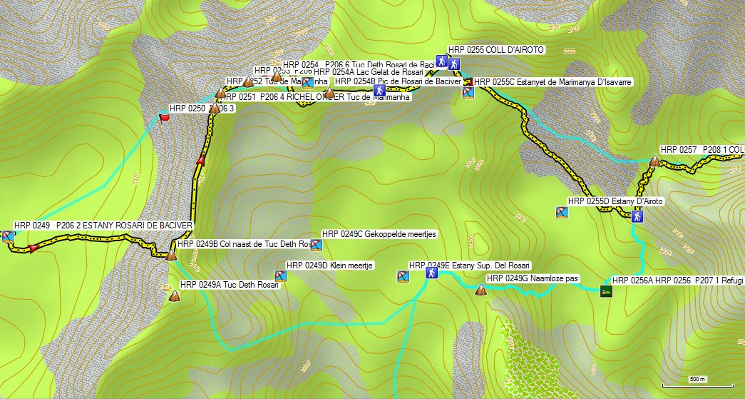
Cross the river between the ESTANY DE BACIVER and ESTANY ROSARI DE BACIVER ( HRP 0249 P206 2 ) and hold it to your left.
Later on, you cross the river twice, to arrive at waypoint HRP 0249 P206 2 ESTANY ROSARI DE BACIVER , a crossroads of paths and especially OSM track logs, because the trails on the terrain are actually vague. Here you have to decide which route you choose for yourself.
In good weather conditions, you can perfectly complete this stage, along the in the Cicerone guide proposed route, but a good knowledge of the terrain provides you with many benefits. In bad weather conditions, you better try to avoid the long passage along the ridge and through the debris fields, described in the Cicerone guide. For this purpose, you can better climb towards the lowest point ( HRP 0249B ) on the ridge next to Tuc Deth Rosari (HRP 0249A). And instead of continuing to the left along the ridge, you descend in a wide arc to the right in the direction of the northern side of the lake Estany Sup. Del Rosari ( HRP 0249B ). Here you will find the path between the REF SABOREDO and Refugi Airoto-Gracia ( HRP 0249C ). This allows you to reduce not only the distance, but also the number of altimeters and the difficulty of the next section.
Basically there are three possibilities:
-
The Cicerone version: Tackle this variant, only in the most optimal conditions. Ton Joosten often writes light heartedly about passages along ridges and through debris fields. The man lives nearby and can choose the ideal weather conditions, to complete the most difficult stages. Moreover, he has the advantage of knowing the area thoroughly. The average HRP hiker is confrontd with these difficulties for the first time. Especially the Spanish maps are of poor quality and the way markings on the terrain are also poor or nonexistent, as he himself admits to, in regard of the climb towards the Tuc de Tuc de Marimanha (HRP 0252). You do not want to be on this ridge in bad weather conditions. First, you have cope with level II climbing and secondly being on a ridge, you find yourself in very exposed terrain for a very long time, which is typical for a ridge, and therefore by definition unsuitable in bad weather conditions. Especially waypoint HRP 0250 P206 3 and the corresponding OSM track pass through a huge debris field, which is highly unpleasant.
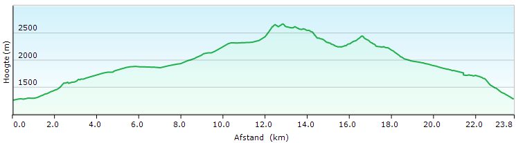
Altitude profile HRp26-27 SALARDU – ALOS D’ISIL (guide)
-
Those, who wants to proceed along the ridge, but wants to avoid the debris field at its foot, climb to a wide open pass on the ridge of the LEDGE UNDER the Tuc de Marimanha (HRP 0251 P206 4) and then walk longer across the ridge. The big advantage is that you can climb to the ridge through easier terrain and that the first part of the ridge is also open.

Altitude profile HRP26-27 SALARDU – ALOS D’ISIL ( Own route)
-
Those, who wants to avoid a prolonged stay on the ridge climb towards the lowest point on the ridge between Tuc Deth Rosari (HRP 0249A) and the Tuc de Tuc de Marimanha (HRP 0252). You will find a track log on the OSM map, but whether this corresponds with a physical path on the ground, could not be determined. From the Col you descend in a wide curve towards the Estany Sup. Del Rosari ( HRP 0249B ), trying to bypass the debris field in the cirque along the valley side. On the eastern side of the lake, you can expect to join the path between the Refugi SABOREDO and the Refugi Airoto-Gràcia, which you follow in an easterly direction to a nameless pass (HRP 0249D). From this pass you descend towards the Refugi Airoto-Gracia (HRP HRP 0256 P207 0256A 1 – incorrect coordinates in the Cicerone guide). At the cabin, you find a good path towards the COLL DE CLOT DE MOREDO (HRP 0257 P208 1) to continue towards ALOS d’ISIL (HRP 0264 P210 3). This route is one kilometer shorter and avoids many difficulties on the route along the ridge presented in the Cicerone guide .

Altitude profile HRp26-27 SALARDU – ALOS D’ISIL (bad weather variant)
Considering the fact that can’t foresee every difficulty in advance can, based on the map and guide only. Considering the fact that certain trails were not visible on the OSM maps, I downloaded in the planning phase of this trip, I approached the Tuc de Marimanha (HRP 0252), I made a combination of option 1 & 2, keeping mostly to the right of the debris field.
Once on the ridge, you have to find yourself the most suitable route on or next to the ridge. You won’t find any indications concerning the route to be followed along this ridge. This section is to be completed at your own insights. And, if you are faced with such circumstances for the first time, while using footwear that is somewhat too light for these conditions, progress may be slow. Fortunately this stage was completed in optimal conditions.
If you follow the ridge over its full length, you need to round another unnamed top which is not visible, nor on the OSM map, nor on the Garmin Basemap, before reaching the LEDGE UNDER the Tuc de Marimanha (HRP 0251 P206 4). You then descends gently to the ledge. You climb to the Tuc de Marimanha and descend back to a pass.
Hence, you climb again to the Tuc Deth Rosari de Bacivèr ( HRP 0254 P206 6 ). You descend from the top, to round the Lac Gelat the Rosari (HRP 0254A), which lies deep beneath you. From the Pic de Rosari de Baciver (HRP 0254B) you’ll find yourself in more traditional hiking terrain.
From HRP 0254C you’ll find again traces of a path and markings that you are to follow in a northeasterly direction towards the COLL D’AIROTO ( HRP 0255 ). From there, you continue in southeastern direction towards the Estany D’Airoto (HRP 0255D). Those who do not wish to stay in the Refugi Airoto-Gracia (HRP 0256A HRP 0256 P207 1) must actually back up to the COLL DE CLOT DE MOREDO ( HRP 0257 P208 1 ).
From here on, there are two possibilities:
-
Follow the description in Cicerone guide and follows the lakeshore through a difficult debris field until you have reached a more open stretch by climbing a bit. There you’ll find the path between Refugi Airoto-Gràcia and COLL DE CLOT DE MOREDO. Depending on whether you want to stay in the Refugi Airoto-Gràcia or at ALOS D’ ISIL, you descend or continue to climb to the col.
-
You climb into the edge of the debris field directly to the COLL DE CLOT DE MOREDO (difficult – OSM -Track Log ).
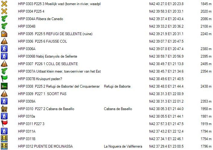
 From COLL DE CLOT DE MOREDO on, the difficulties stretches for this day are behind you, and you can follow a regular trail. The path deviates slightly from the OSM track log. You pass through a SORT OF PAS (HRP 0258 P209 1).
The trail ends at a gravel road ( H RP 0259 P209 2), along which you continue to descend to the entrance road to a farm. Here you turn left and follow a minor road to the BORDES DE MOREDO (HRP 0261 P209 4).
Follow a rather vague path to the edge of the forest (HRP 0262 P210 1). Here you turn right and start the descent towards ALOS d’ ISIL. You cross a riverbed (HRP 0263 P210 2), which can be dry sometimes, to continue descending further along the Barranc de Moredo in a southeasterly direction to a dam (HRP 0263A Dam on the Barranc Moredo) at the end of a road. From here on, you will find a path towards ALOS d’ ISI . At the end, the trail becomes a road. The road opens onto a small square. At this square, you’ll find the Refugi Alos d’Isil (HRP 0264B) to your right.
Refugi Alos d’Isil (HRP 0264B)

https://refugi-dalos-disil.business.site/
+34 644 045 719
+34 624 461 487 (Silvia)
La Placeta, Alós (Alt Àneu)
25586 Catalunya, Spain
(20 beds in a loft under the roof, two showers, two toilets, supplies in the form of frozen or canned food and other food with a long conservation time, well equipped hikers kitchen, lounge, dining room). No recent rates online!
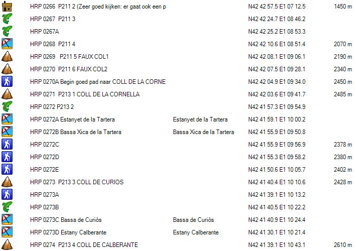
Day 28 ALOS d’ISIL – REF. ERIC PUJOL |
13km | +1600 | -600 |
Total: without rest: 6:30′ including rest: 8:45’ (difficult orientation)
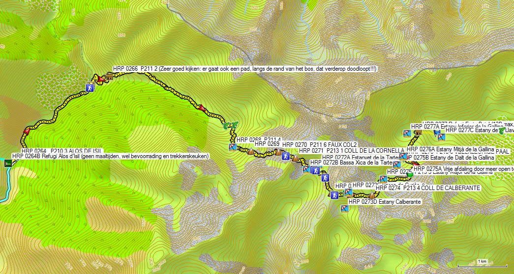
 You leave the inn and descend slightly between the houses in northern direction, until you get back on the C-147. Along this road, you climb slowly over a distance of 2 km. You leave it (HRP 0265A) via a gravel road, which leads you down to a wooden bridge (HRP 0265 P211 1). From here on, you climb along the gravel road. You pass a metal cattle gate, entering slowly in cow territory. You follow the road until it ends at two huts, the one on the left being remarkably smaller than the one on the right.
Here you have to watch out very well. Go between the cabins, in the direction of the woods to find a path that turns off to the right. Caution: not to be confused with another narrow path which it to be found slightly lower in the meadow, which finally ends at a bend in the river (Baranc de Commamala) .
Once you have found the right path, it’s fairly easy to follow to the lake (HRP 0268 P211 4) in the cirque under the FAUX COL1 (HRP 0269 P211 5). The path first diverts away, to gradually close back in onto the main river through the valley .
Near the confluence of the feeder rivers, you need to deviate to the left of the main river, in order to cross over the river left branch. Then, you have to return to the main river and follow it until you reach a small lake (HRP 0268 P211 4).
Caution: do not follow here the longitudinal axis of the lake, but deviate to the left in southeastern and later eastern direction.
The biggest problem here is that both the OSM and the Garmin Basemap do not show enough detail to be able to orient yourself visually in the field. This, you should do based only on the track log, if you don’t have a sound (French) survey map with you.
The indications on the terrain are nonexistent or ambiguous, and could lead to confusion. An additional problem is that there are many cols. So, initially it’s important to focus on the right col.
First Faux Col is not very clearly visible in the landscape. The second is better visible. From the second Faux Col onwards, you take a turn to the right towards waypoint HRP 0270A, where you find the beginning of a good path, that leads you to the COLL DE LA CORNELLA .
From COLL DE LA CORNELLA the situation is much clearer. You can see the lakes Tartera beneath you and your next climb, being the COLL DE CURIOS (HRP 0273 P213 3) ahead of you. The path passes between the two Tartera-lakes, but differs in detail from the OSM-track log. Just after the passage of the river, connecting both lakes, you’ll find white-red paint marks and a flattened signpost, which isn’t much help. From waypoint HRP 0272 E on, both the path on the terrain coincides with the OSM-track log. In the south direction, you climb to the COLL DE CURIOS (HRP 0273 P213 3).
 You descend from the COLL DE CURIOS and at the outlet river (HRP 0273A) of the Bassa de Curios (HRP 0273C), you follow this upstream to the lake. Just before the lake you cross the outlet river (HRP 0273B) and continue to climb further towards the COLL DE CALBERANTE (HRP 0274 P213 4).
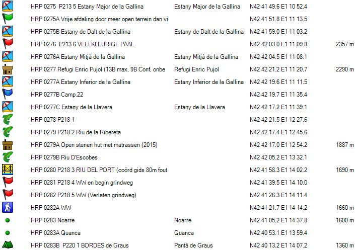
From the COLL DE CALBERANTE, you descend towards the Estany Major de la Gallina ( HRP 0275 P213 5 ), which you round clockwise. Behind the lake, the course of the trail becomes difficult to follow, especially from waypoint HRP 0275A onwards. The cairned trail follows a course through the debris field on the left bank of the river valley. You can also opt for a free descent through the more open right side of the river valley. The ultimate goal of any selected route is a multicolored pole (HRP 0276 P213 6) , which is clearly visible from the upper half of the valley.  From the multicolored pole, you continue north, along the right bank of the Estany Mitjà de la Gallina ( HRP 0276A ). Then you cross the outlet river from the lake twice, to continue in a straight line in northern direction towards the Estany Inferior de la Gallina ( HRP 0277A ) and the Refugi Enric Pujol (HRP 0277) .
 Just before the Refugi Enric Pujol, you have it cross the outlet river of the Estany Inferior de la Gallina. This crossing is a little uncomfortable. Just before this crossing, there is a small peninsula that you rounds clockwise to a kind of small dam in the form of boulders just below the waterline. The inconvenience of this crossing is in the fact that you need to hold on with your hands to the face of the peninsula rock in the last part of the rounding. Then you will need to step down on the stones that lie just below the surface, releasing yourself from the wall and seeking support on your walking poles underneath the waterline, to sufficiently stabilize yourself and venture the next step towards the other side. The execution of this crossing requires a large dose of self-confidence and caution. Errors will result in guaranteed (partially) wet clothing and equipment.
On the other side, you follow the path up towards the Refugi Enric Pujol (HRP 0277) .
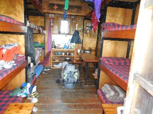
Refugi Enric Pujol:

Unmanned metal cabin with 9 up to 13 beds with mattresses, blankets and pillows. The top 4 beds, just below the convex roof, may be considered to be very uncomfortable. There is a table with benches and stools. There is no toilet and water should be taken from the stream.
Day 29 REF. ERIC PUJOL – REF. CERTASCAN |
14km |
+1100 |
-1100 |
Total: without rest : 7:30′: including rest: 8:00′


 You leave the hut, to descend in line with the longitudinal axis of the cabin. Ahead, you’ll find cairns. The navigation here is relatively easy. You should weary however because of the large number of major dismounting combined with wet and slippery rocks. Extending your poles with 30cm here, is expedient in the steepest part.
You descend towards the Estany de la Llavera ( HRP 0277C ), after whichyou make a turn of almost 360°. Then, you descend along the left bank of the Torrent de Roia de Mollàs . At waypoint HRP 0278 P218 1, you cross your first small stream. The path moves away from the Torrent de Roia de Mollàs and at waypoint HRP 0279 P218 2, you cross a larger tributary, being the Riu de la Ribereta. Subsequently, the path continues towards a freely accessible stone hut with mattresses (2015) , which could serve as an alternative to the Refugi Enric Pujol.
You descend further in a southeasterly direction and slowly in more wooded terrain. At waypoint HRP 0279B, you cross the Riu D’Escobés. Near the RIU DEL PORT (HRP 0280 P218 3), you leave the forest and get into the pastures. This makes the path fade.
Don’t go looking for the wooden bridge over the RIU DEL PORT too high, because Coordinates given in the Cicerone guide, are around 80m divided from the actual position of the bridge, and that’s disturbing. After crossing the river the path continues in a southerly direction and divides itself soon from the river. At waypoint HRP 0281 P218 4 the path at a gravel road in a hairpin bend. You’ll find a amputated signpost, with only indications in the direction from which you came.
 Follow the road south over a distance of 450m and leave it at the next signpost (HRP 02 82 5 P218 WW) for a path that remains largely at level. 150m further you will find another signpost (HRP 0282A WW). From here on, you’ll find signs towards the Bordes the Noarre and the Refugi de Certascan. You descend to Noarre (1595m), a hamlet with restored holiday cottages.
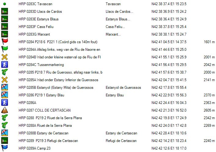
In addition to an information panel, you can find two signposts, one indicating the Refugi de Certascan (HRP 0284 P218 P221 6 1) The in the Cicerone guide specified waypoint is around 140m off location. From Noarre on, you find white-red markings.
 From the second signpost, you walk in a northeasterly direction. Beyond the second building, you turn left and then you turn left off a wall. The trail approaches slowly the Riu de Naorre, to leave it again abruptly to the left uphill, at waypoint HRP 0284A. Here begins an climb in zigzag through the forest , which in a large turn will bring you back to a wading point under the small waterfall on the Riu de Flamisella, which is one of the feeder rivers of the Riu de Naorre. You continue to climb a little further, to turn north. You arrive in a cirque with a meandering Riu de Guerosso. You need to be careful here, to keep your feet dry.
At waypoint HRP 0285 7 P218, you find a GR-type of signpost that marks the turnoff to the left. You find yourself at the beginning of a more technical climb through the face of the mountain, with many rock plates combined with loose rock. You are glad to have climb this trail, rather than having to descend it. Be extra careful on rainy days. Once you’ve crossed the outlet of the Estany Inferior the Guerossos (HRP 0285A), the hardest part is over. The path continues to climb steeply and then turns north. Because of the white-red and green markers, there are no problems here orientation wise. You approach the river again near the small Estanyol (Estany Mita) the Guerossos (HRP 0285B). Higher up, you reach the larger Estany Blau (HRP 0286 P219 1).
Here the path turns to the right. From waypoint HRP 0286A on, the path deviates from the OSM track log to the COLL DE CERTASCAN ( HRP 0287 ).
 The descent of the COLL DE CERTASCAN is heavily eroded, but well marked with wooden poles. The poles however are not provide with barbed wire, allowing them to be used by the animals as a scratching post, through which they suffer heavily. Below, at waypoint HRP 0288 P219 2, you cross the first time the Riuet Serra de la Plana.
Before the lake, near waypoint HRP 0288A, you cross the river twice. You round the Estany de Certascan ( HRP 0288B ) along the south side. The Refugi de Certascan (HRP 0289 P219 3) is not situated along the lake itself, but in a gully behind a hill.
Refugi de Certascan (FEEC): 

Tel (+34) 973 623 230
40 beds – 2 showers – 2 toilets – toilet paper bucket.
Shoe racks – Teva’s available – backpack to be left behind in numbered box, with the same number as your bunk bed. Wood stove to warm up the cabin and to dry your laundry.
Note: huts in Catalonia don’t recognize foreign mountaineering cards, so you don’t get a members discount here 😦.
Dinner: 7:30pm
Breakfast: 7:00am
Bread, butter, jam, cereal, coffee, tea and rather watery juice, biscuits and cakes (self-service) (no plate, one glass (saves washing up 😦).
Half board: 60,50€ (Shower included) (2024)
Half board + Picnic: 75,50€ (2024)
Day 30 REF. CERTASCAN –REF . VAL FERRERA (GR) |
17.5km | +1350 | -1600 |
Total: without rest: 8:15′, including rest: 9:00’
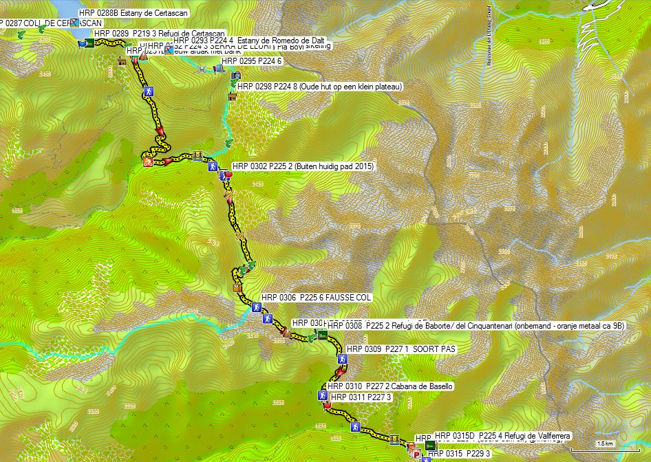
Choice of route:
To reach the bridge at the Pla de Boavi there are two possibilities:
- The Cicerone HRP variant: this variant is 1km longer and results in 125m additional altimeters. You descend along the marked trail towards a split between the path to parking lot and the path with the white-red marks. Around 20m further, there is a second split (HRP 0291A) between the path to the SERRA DE LLURI ( HRP 0292 P224 3 ) and the white-red marked trail to the Pla de Boavi. From this junction of paths, climb in zigzag up to a height of 2225m, after which you turn left and descend back to the passage towards the col of the SERRA DE LLURI. You descend further towards the southern edge of the lake Estany de Romedo de Dalt (HRP 0293 P224 4). You continue your way along the outlet of the lake until you reach the southwestern flank of the Estany de Romedo Baix (HRP 0296), where you have to deal with a very difficult passage.
You continue in the direction of the road that returns to the car park under the Refugi de Certascan. You continue over the dam of the Estany de Romedo Baix . At the end of the dam you find a vague trail on the right (east).
The trail approaches the Riu de Romedo. In the descent, first you see a waterfall (HRP 0297 P224 7). Then you cross the tributary, Barranc de Salibarri (HRP 0297A). You continue to descend freestyle en route to a cabin on a small plateau (HRP 0298 P224 8). Keep this cabin to your right, to find traces of a path and a couple of cairns. Be careful in a rocky section and continue to descend a the site under a waterfall, where you will finally have to cross the Riu de Romedo ( HRP 0299 P224 9 ). Especially this last part from the crossing of the river to the Pla de Boavi is in the Cicerone guide described as: “Find your own way down in the forest. Here and there are traces of a path and a couple of cairns. Return to the river and follow it to the Pla de Boavi.” Based on the description in the Cicerone guide, is apparent that the descent is very difficult both technically and in terms of orientation. The additional value of this choice eludes me completely. Is this again a prestige choice, with a high degree of machismo?

Altitude profile HRP30 REF CERTASCAN – REF VAL FERRERA (guide)
-
Leave the hut in an easterly direction and descend towards a lake. Round this lake along the northern shore. Follow the path east and then south until you cross the outlet of the Estany de Punturri (HRP 0290 P224 1). Descend further in a southeasterly direction to the split between the path to parking lot and the path with the white-red marks. Around 20m further there is a second split (HRP 0291A) between the path to the SERRA DE LLURI ( HRP 0292 P224 3 ) and the white-red marked trail to the Pla de Boavi. Follow this path that climbs slightly to descend until you finally arrive at the road to the dam of the Estany de Romedo Baix. Do not follow this road, because it will lead you back to variant 1 (HRP). Cross the road and follow the path down to the Pla de Boavi. Please note that the rocks on the path under the trees line can be very slippery. Once you reach the road at the Pla de Boavi, follow it to the left. The road is initially flat and fades into a grassy plain. Make your way along a path to the bridge over La Noguera de Lladorre. In 2:30′ you rejoin the Cicerone HRP-variant, which is more than 30 “less than the time specified in the Cicerone guide (3u05’).

Altitude profile HRP30 REF CERTASCAN – REF VAL FERRERA (GR)
You cross a bridge. On the other side, you need to take good look around forward to the path. Both the traces on the ground and the OSM-track log follow a path which runs dangerously close to the Riu de Broate. At waypoint HRP 0300A you return to a good mule trail, which you follow up to the bridge over the RIU DE SELLENTE (HRP 0301 P225 1), a tributary of the Riu de Broate. After the bridge, follow the river a 50m upstream, only to leave the main path at a makeshift signpost. You climb up along a cattle path to return back to the original path after 50 altimeters. The reason for this redirection was unclear. Higher up, you return to the river. At waypoint HRP 0303 P225 3, you need to cross a difficult ford, with trees in the riverbed. You have to choose a ford in relation to present situation. The coordinates listed in the Cicerone guide are about 85m away from the normal ford.
1km after the first ford, you cross the RIU THE SELLENTE again ( HRP 0304 P225 4 ) at a shallow ford in a rocky area. 650m further you cross one of the tributaries of the RIU DE SELLENTE, being the Ribera de Canedo (HRP 0304A).
You diagonal cross all the river branches, in the direction of waypoint HRP 0304B to continue to climb in zigzag towards the ruin of the REFUGI DE SELLENTE (HRP 0305 P225 5).
You continue along the river for about 250m, to continue towards a FAUSSE COL ( HRP 0306 P225 6 ). Over there you find a path to the right towards Tavescan.
Higher up you pass along the Estanyols de Sellente to continue climbing towards the COLL DE SELLENTE (HRP 0307 P226 1). You descend from the Col to the right through the debris field. You take a sharp turn to the left and leave the debris field over a grassy slope. You descend towards the you outlet river of a small lake, which is also a tributary river of the Estany Baborte . From here on, you continue in an easterly direction towards waypoint HRP 0307B .
Whether this is an intersection of paths, is not so clear on site. From here on, you go southeast to the Refugi de Baborte /del Cinquantenari (HRP 0308 P225 2 – unmanned – orange metal 9 beds) . The orange color of the cabin is already visible from afar.
Refugi the Baborte / del Cinquantenari:

Unmanned metal cabin with 9 up to 13 beds with mattresses, blankets and pillows. The top 4 are situated just below the convex roof and must be considered to be very uncomfortable. There is a table with benches and stools. There is no toilet and water should be taken from the stream.
The choice for this stage point in Cicerone guide is incomprehensible, unless you make it harder than necessary for yourself by following the Cicerone variant in the first part of stage 30, and as a result have to make halt at the Refugi de Baborte / del Cinquantenari. Obviously, the choice for an unmanned cabin results in the fact that you have to carry extra food and fuel with you in your backpack.
The proposed descent to Bordes de Graus and / or Tavescan is in that respect unimaginable, if you know that you can find provisions at Arinsal. The nature of the in the Cicerone guide proposed stage between Refugi de la Comapedrosa and El Serrat, must be classified as totally artificial and far-fetched. The GR11 should be labeled in this respect, as a much more sensible choice.
You can also cut short from the Refugi de Vallferrera towards El Serrat. This is the shortest route, but you pass through the mega-ski area Arcalis and there are no supplies to be found along this variant. 200m past the exit to the Refugi the Vallferrera, you find another signpost with the exit towards the Port de Boet (HRP 0316C – 2511m). Through this pass, you reach the French valley Soulcem. If you round this cirque, you reach the border with Andorra on the other side. Through this border pass ( HRP 0317G PASS – BORDER (2515 meters) ) you reach the cirque of the ski resort Arcalis. Along the path or by road you reach El Serrat.
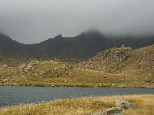 You pass behind the Refugi de Baborte /del Cinquantenari and descends towards the Estany de Baborte . Then follow the eastern shore of the lake. At the end of the lake turn left to a SORT OF PASS (HRP 0309 P227 1). You descend from the pass through difficult terrain with lots of tall bushes and therefore hardly visible stones. You descend towards the Cabana de Basello (HRP 0310 P227 2). You remain on the same river bank and to descend further to the left, towards the forest. In the forest you remain leveled for a while, to descend further down towards waypoint HRP 0311 P227 3. This part is surprisingly difficult through a combination of slippery stones small level differences. At waypoint HRP 0311B, you cross a bridge over a tributary river. At waypoint HRP 0312, you cross the PUENTE DE MOLINASSA over the main river. At waypoint HRP 0313 P229 1, you reach the gravel road through the valley. You cut short the various bends in the gravel road, to reach the parking lot of LA MOLINASSA (HRP 0314 P229 2). Here starts the car-free stretch of the gravel road that leads to the turn-off (HRP 0315 P229 3) to the Refugi de Vallferrera (HRP 0315A P225 4).
Refugi de Vallferrera:
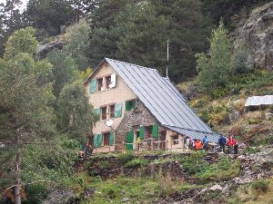
Tel (+34) 973 624 378
Dinner: 7:00pm:
Soup, salad, chicken, yoghurt
Breakfast 7:00am:
1 cup of coffee or tea, 2 slices of bread, 5 to 6 cakes, jam, butter, no fruit juice (no self-service, (plenty of calories, but high in sugar and low on fiber)
Half board: 61,50€ (Shower included) (2024)
Half board + Picnic: 75,50€ (2024)
Day 31 REF. VALL FERRERA – ARINSAL |
15km | +1000 | -1450 |
Total: without rest: 7:00′, including rest: 8:00′

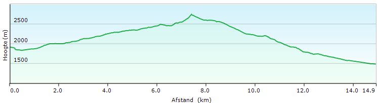 You leave the hut and return in your footsteps towards the gravel road. You turn left and after just 200m you pass the signpost (HRP 0316 P229 5 GR11) to the Port de Boet (HRP 0316C – 2511m – possible variant, see italic above). You continue straight ahead, and again 200m further, you continue straight ahead along a path, at the first hairpin bend (HRP 0315E) in the gravel road.
At waypoint HRP 0315F, you don’t cross the first bridge, but you continue straight ahead along a difficult to follow path on the bank of the river. 200m further you reach an OPEN SPOT (HRP 0317 P225 6). Over here, you cross several small streams via three small bridges, which are sometimes a bit superfluous. Through a small valley, you climb to a plateau, where you can cross the stream (HRP 0318 P225 7). You round a ridge, along which you climb further up. The path is sometimes difficult to follow. Be careful to follow the cairns and paint marks. The frequency of way marks should be higher here. You cross the outlet of the ESTANY D’ASCORBES HRP 0319 P230 1). You continue to climb, while approaching the outlet of the Estany de Baiau, which you cross at waypoint HRP 0320 P230 2. The Refugi de Baiau – Josep Maria Montfort (HRP 0321 P230 3 – 9 beds unmanned), can be spotted from afar because of its location on a hill, and of course because of its color (orange).
Refugi the Baiau – Josep Maria Montfort:

Unmanned metal cabin with 9 up to 13 beds with mattresses, blankets and pillows. The top 4 just below the convex roof, are considered to be very uncomfortable. There is a table with benches and stools. There is no toilet and water should be taken from the stream.
Descend the hill and passes along the north side of the lake. At waypoint HRP 0321A you have to climb the hill to pass up along the vertical rock face, because passage at the bottom of the face, along the lakeshore is not possible. You descend immediately back to the level of the lake.
At waypoint HRP 0321B, there is a fork, which is not designated as such. You see a path that goes up to the left. This should not followed. You continue through the grass -covered banks of the lake to the field of boulders at the end shore of the lake. You follow the cairns through this field of boulders. Further on, the rocks become bigger, leaving back some grass and earth in between. The path slaloms in between these rocks. Higher up, the rocks are smaller again. And again, the cairns are too small tobe spotted from afar, making the “path” difficult to follow. At waypoint HRP 0321C, you’ll find the beginning of a more obvious path.
The last part to the PORT DE BAIAU (HRP 0322 P230 4) is so steep, that with every two steps you take, you slide one backwards. You need to be constantly looking for support in the fine loose gravel. You’re glad that you’re up on the pass, especially since the latter part of the climb is very uncomfortable. Although this is GR11, do not underestimate the technical difficulty of this climb. The fact that it isn’t well marked, doesn’t make things any easier either.
Once on the Andorran side, the character of the path changes completely. You’ll find both white-red GR-type way marks as yellow dots as a way marks. At the weekend you’ll find many people wanting to climb the nearby Pic de Comapedrosa.
 You descend towards the Estany Negre (HRP 0322A), which you round along the left (east) bank. 100m further you’ll find the junction between the path to the PORT DE BAIAU and the Pic de Comapedrosa. You descend towards a lake and cross its outlet (HRP 0324A).
Initially you descend in a southern direction. Around 2500m, this changes in a southeasterly and later easterly direction towards the bottom of the valley. There you will find an unmarked junction (HRP 0324 P231 1). Those who wants to be in the Refugi de la Comapedrosa (HRP 0325 P231 2 – expensive), take the climbing path to the right.
Refugi de la Comapedrosa (HRP 0325 P231 2)
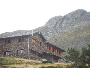
60 Beds, Tel: (+376) 327 955
Unless you want to follow the Cicerone variant, it’s pointless to stay here.
Off this Cicerone variant, you can find track logs on the OSM map untill the BORDES DELS PRATS NOUS (HRP 0333 P235 4 ). From the Refugi de L’Angonella (HRP 0338 P235 9 – 6B unmanned), again track logs can be found to Llorts and El Serrat. According to the Cicerone guide, this route is highlighted and being in Andorra the markers usually are of better quality than elsewhere. But my key criticism of this variant in the Cicerone guide is that it’s farfetched and completely artificial in it’s conception, and therefore does not contribute to the safety or comfort of the HRP hiker.
A wise man goes at the unmarked junction (HRP 0324 P231 1) under the Refugi de la Comapedrosa, straight ahead and leaves the cabin for what it is. 500m further you walk towards a col and slightly below, you’ll find a signpost (HRP 0326 P233 1) to the hut. The descent runs through steep and eroded terrain. At waypoint HRP 0326A you cross a river. Shortly after the river, you enter the forest.
The further course of the path is quite hassle free. At waypoint HRP 0327 P233 2 (large deviation, from the in the Cicerone guide specified position) you cross a first bridge. At waypoint HRP 0327A, you cross a second bridge. You descend further down towards a hairpin turn in a gravel road (PLA DE L’ESTANY (HRP 0328 P233 3 – 1745m)). The Cicerone variant sends you up along the gravel road.
Wise people continue to descend further along the gravel road (HRP 0328A) until you reach the tarmac. You descend further towards a small parking lot (HRP 0328B), to pass through the tunnel (HRP 0328C) towards Arinsal. Over here, you take the downward direction and follow the asphalt over a distance of just one kilometer to the center of Arinsal. Here you’ll find the hotel Hotel Comapedrosa ( HRP 0329H ).
Hotel Comapedrosa:
Room 101: 1st floor, street, 2 balconies, shutters and double glazing. Little traffic at night. Full private bathroom, shower and hairdryer, which rapidly become overheated.
Room 102: noisy because of the river (probably true for all the rooms along the backside of the hotel) .
Room with half board: 60€ (Hotel website) (2024).
Dinner (from 7pm on…): Platos combinados: normally, I become very nervous, when reading this phrase, because most of the time it’s an expensive but inferior version of a menu. But over here, you get real value for your money: 3 slices of pork, salad and French fries (ample portion). A bottle of fine wine at the bar (spread over three glasses). Same bottle at dinner and on the hotel bill, and together with the food suddenly costs € 2 extra. Still no theft, but odd …
Breakfast (8am) : Bread, croissants, cakes, sweetened cereals, butter, jam, ham, cheese, chorizo, three kinds of juice, water, milk, all in buffet style. Please beware of the coffee machine, especially if you want tea or hot water. Sometimes water with coffee residue, might come from the water outlet. So test first, before you put your tea bag in your cup …
Day 32 ARINSAL –El SERRAT |
10km | +750 | -650 |
Total: without rest: 3:30′, including rest: 4:00′

 A kind of rest day. Time for shopping and just some rest for your body. Besides luxury hotels nothing can be found at El Serrat. For those who find El Serrat too expensive, despite the summer sales through www.booking.com , may seek shelter in the Refugi de Sorteny. This hut is no longer freely accessible. Additionally, you need to be with a minimum of 6 people to make a reservation 😦 (more info: see below).
You leave your hotel and go downhill. 200m further you leave the main road and climb up the C-412 through the ski village of Mas de Ribafeta until almost the end of the street. In the last hairpin bend, you will find a signpost. At the beginning of a forest, you’ll find a path that leads you away from the asphalt. The climb is very steep. You work yourself in sweat, but the path is good. The Coll de les Cases GR11 (1 HRP 0329D – 956m) itself is narrow and treeless. You’ll find a signpost: to the left, you go to the Pic de Percanela (2495m), to the right to the Col de Jou.
Straight ahead, Arans is indicated. You follow this path at first, but you’ll leave this at waypoint HRP 0329J (Leave OSM track log ) in order to return to another OSM track log at waypoint HRP 0329K, along which you reach Arans. You pass a junction (HRP 0329L), where you go down towards a stream (HRP 0329M). After the stream, the path is somewhat difficult to find. It proceeds on top of a wall. You descend further, to reach the tarmac (HRP 0329O) at Arans. You descend towards the main road and cross it. At the opposite side of a bridge, you will find a signpost (HRP 0329P), where you leave the GR11 to the left. From here on, El Serrat is indicated at the signposts.
You follow the gravel road to the left, while ignoring all the steep climbing turn-offs to the right. At waypoint HRP 0329S you can either go left and immediately cross the river and follow the main road to the right. But you can also continue a little further, keeping to the left bank, past the iron mine, to cross the river and return 100m to the left along the road, to find there a gravel road at the back of the hotel. You can find a signpost indicating El Serrat (HRP 0329T).
Note: The description in Cicerone guide sends you here, along the road to El Serrat. Not very HRP friendly!
You follow the gravel road on the right bank of the river. At waypoint HRP 0329V you return on the asphalt. You follow this until the roundabout. Again, you stay on the right bank and continue your way straight ahead along a dirt road, which fades a bit. At waypoint HRP 0329X, you arrive again at a bridge. 150m further, there is another one. Use one of the two bridges to reach the left bank and continue briefly along the CG-3. You leave the road soon, at the opposite side, to cut short a hairpin bend in the main road. You pass along the chapel of El Serrat, to regain the tarmac. The “village” El Serrat actually consists exclusively of hotels and a ski shop for the Arcalis ski area, higher up the mountain.
Hotel El Pradet / Bringue:
Those who are smart book here the cheaper El Pradet, through www.booking.com , where this hotel is actually closed and only the restaurant and bar are open during the afternoon. In fact you end up in the annex of Bringue hotel, located opposite the eponymous hotel and next to El Pradet. These hotels are all under the same management.
Given the restaurant El Pradet is closed at night, you have to eat at Hotel Bringue. Breakfast is also served there.
Dinner (8pm):
- Russian salad
- Pork with mustard sauce, pasta and broccoli
- Dessert
Bottle of house wine: Fairly expensive!
50cl Mineral water: Expensive! (so ask for Aqua Naturale or tap water )
Half-board 2 persons: € 84 (2024)
Breakfast (07:45am, but, not everything is ready):
Really fantastic breakfast: bread, croissants, 4 kinds of cold meats, smoked salmon, bacon, scrambled eggs, sausage, melon, peeled oranges, yoghurt, four kinds of juice, coffee, tea … This breakfast can get you through more than half a day.
Day 33 El SERRAT – CABANA COMS DE JAN |
11km | +1300 | -600 |
Total: without rest : 4:30′, including rest: 5:00′


Technically speaking, a quite simple stage, which is well marked nowadays as regional-GR with yellow-red paint marks. Forget the description in the Cicerone guide.
Leave your hotel and climb up the CG-3. You pass the even more chic Chalet Bringue **** ( HRP 0343H). You leave the road straight ahead, at the next hairpin bend (HRP 0344 P237 1), via a path on the left of the driveway to a retreat.
You follow the path 400m uphill to a bridge, where you cross the Riu de Rialb (HRP 0344A). 300m further you cross another bridge and there you will find a junction, where you persists to the right. It goes uphill in a southeasterly direction until you reach a gravel road. You can either follow the gravel road to the right or use one of the short-cuts, which are very steep. Once up, you pass a small botanical garden ( HRP 0344F Botanic Garden ) along the side of the road. The gravel road climbs further up to a parking lot (HRP 0344G). From here on, the road is closed off to the public in general by a gate. Further on the road fades a bit, but it extends to the Cabane Borda Sorteny (HRP 0345 P237 2)
Refugi de Sorteny:

Tel: (+376) 846446
Prices 2024: Half board: 65€ (2024)
The cabin, which can accommodate up to30 people, was used by park rangers. It is not freely accessible anymore. Reservation is required, either by phone or over the internet. Electric power provided by a small generator. Half board available.
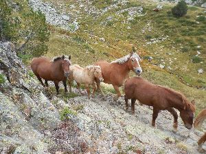 You round the Cabane Borda Sorteny along the left side. Here you will find a path uphill to the east. It does not coincide with the OSM track log , but remains left of it. You approach the river and cross it by a bridge (HRP 0346 P237 3). The path was redirected away from the river gulley of the tributary. You reach the side valley again, after you’ve gone through a cattle gate. In the side valley, you climb further up and cross the river at waypoint HRP 0347 P237 4. You reach a junction of paths and continue on the left bank. You climb up to the COLLADA DELS MENERS (HRP 0348 P237 5).
Just before the col, you find a cabin (HRP 0348A). You descend through a gulley to the right of the Col , first in southern, then in eastern and northern direction, allowing you to make a sort of semicircle. Above the Estany de Ransol ( HRP 0350A ), you find an intersection of trails.
The Cicerone guide sends you downhill here, towards the car park and then back uphill towards Cabana Coms de Jan. This is again, an uncomprehensible choice. The yellow-red marked trail remains at level and is less physically difficult. You make a big turn clockwise. At waypoint HRP 0349B, you cross a kind of col, after which the descent in the direction of the CABANA COMS DE JAN (HRP 03 53 P240 3) is commenced. In the last part of the approach towards the hut, you pass underneath a steep slope.
CABANA COMS DE JAN (8 beds – unmanned) :
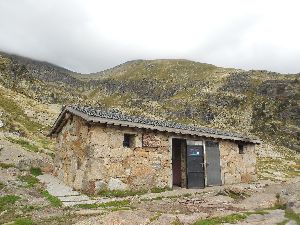
Hut is divided in two parts. The left part contains a wood stove, without any wood, 2 bunk beds for 4 people, the lower 2 having a “6mm mattress” of closed cell foam. It’s better than nothing, but not much. There is a table with two benches. The right half has only two bunk beds for four persons without any kind of mattress, blanket or pillow. In each section there is a window in single glass and a metal door.
Near the hut, there is a black plastic hose, which carries water that comes from above, on the slope. About the water quality, nothing is known. Filtering or boiling it before consumption is the message. There are no sanitary facilities. Pretty Spartan…
During the night there were wind speeds above 100km/h, in combination with a clear sky, which resulted in very low temperatures. In bad conditions, a light sleeping bag, fit for cabin use is insufficient. Whether you want to carry along a mattress, which you might use during only one night, is a personal decision.
Day 34 CABANA COMS DE JAN – REFUGE DU RULHE |
11.5km | +1000 | -1000 |
Total: without rest: 4:45′, including rest: 5:30’
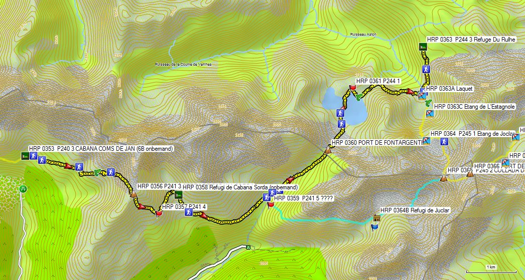

You’ll leave the hut, remaining at the level, going in an easterly direction towards the river bed, which you can see from the cottage. The first cairn (HRP 0353A) is difficult to see from hut, given the fact that it’s quite far away from the hut (150m). Further on, the course of the path is fairly obvious.
You climb slowly into the flank of the mountain. At waypoint HRP 0354 P241 1 you cross the first river gully. At waypoint HRP 0355 P241 2, you cross a second. At waypoint HRP 0355A, you reach the debris field, and from this point on, the path is easy to follow to the SERRA DE CABANA SORDA (HRP 0356 P241 3).
From the col, you descend steeply towards waypoint HRP 0357 P241 4. Here you turn left and you stay 150m more or less at the same level, after which you descend to the small dam of the reservoir. You cross this dam and return in the direction of the Refugi de Cabana Sorda (HRP 0358) .
Refugi de Cabana Sorda:

Unmanned, 12 beds, no mattresses, blankets or pillows, 2 tables, fireplace and BBQ
The path, leaving from the hut, is rather vague. Lower in the pasture (HRP 0358A), the path becomes clearer.
The path descends in a wide arc towards the valley bottom. At waypoint HRP 0358B you will find a signpost. It’s best that you walk here on sight to the upward going path to the PORT DE FONT ARGENTE/PORT d’INCLèS (HRP 0360). Without any hassle you reach the col.
 The descent to the Etangs de Font Argenta is difficult, because of the many bolder fields you have to cross. You can see the hut from a distance, but the path toward it is difficult. At the end of the lake, the path becomes a little easier again. You follow it to the end (HRP 0361 P244 1), where the path makes a bend around the lake. Follow the shore to a gully, through which you leave the shore. At the end of this gully, you do not descend into the green valley, but you remain in the bolder field in the face of the slope at more or less the same height. In the cirque of the Ruisseau de L’Estagnol there is a relatively leveled path where the boulders were stacked in a more or less orderly fashion to create a man made path. Yet, the path remains difficult until the crossroad, with the path coming from the COLLADA DE JUCLAR (HRP 0365 P245 2). Here you go left, to climb slowly in the direction of the Refuge Du Rulhe (HRP 0363 P244 3).
Refuge Du Rulhe: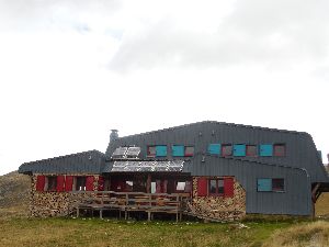

Tel (+33 ) 5 6 1.65.65 . 0 1
Showers only from 5pm on 😦
Dinner at 7:30pm (officially), 8:00pm (eventually):
- Soup
- Spaghetti with beef stew
- Cheesecake
Breakfast 7am:
Bread, muesli, cornflakes, milk, coffee, tea, butter, jam
Half-board: 45,00€ (2024)
Quadruple Room for the two of us (no snoring!!! :-)))).
Day 35 REFUGE DU RULHE – HOSP. pres d’ANDORRA |
14km | +600 | -1400 |
Total: without rest: 6:00’, including rest: 7:30′


 You return in yesterday’s footsteps towards the junction between the paths to the COLLADA DE JUCLAR (HRP 0365 P245 2) and the PORT DE FONT ARGENTE/PORT d’INCLèS. You don’t cross the river, to continues straight on, on the right bank of the Laquet (river – HRP 0363A) .
Further on, at waypoint HRP 0363B, you cross the outlet of the Etang de L’Estagnole (HRP 0363C) and continue on the left bank of the lake. You continue towards an impressive scree, which is largely circumvented by the path. The trail is well laid out in view of the use of mules.
 You reach a kind of col and then the Etang de Joclar (HRP 0364 P245 1). You around the lake clockwise. In this area, there are a few technical passages. The col where you are going to, is not immediately visible from the lake. The climb itself to the COLLADA DE JUCLAR ( HRP 0365 P245 2 ) is fairly easy.
You cross the col , to climb behind a shoulder of the Pic de Ruf to the PORT DE L’ALBE (HRP 0366) to the ridge between the Pic de Ruf and the Pic de Noe.
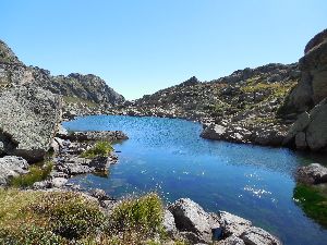 The descent of the PORT DE L’ALBE is very difficult because of the bolder field. You descend along the left side of succession of lakes: Etang Haut de L’Albe (HRP 0366A), Etang Bas de L’Albe (HRP 0366B) and the Etang de Couart (HRP 0367 P247 1). At the end of this last lake, you’ll find great pitches. Just before the end of the flat part of the valley, you have climb up to the right in the flank of the valley. There is no signpost to mark this change of direction, just a GR-style white-red painted Andrew’s cross, a few meters past the turn-off.
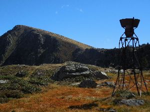 Once over the edge of the plateau, you see an old rusty pluviometer. You pass along the base of the meter, after which the path becomes again somewhat difficult to follow. The pass itself is clearly visible and once at the Couillade de Pédourés (HRP 0367D), the path becomes clearly visible again. You descend in a wide arc along the ramp around the lake, to continue descending towards the floor of a demolished building. You pass a small waterfall here, which is marred by a concrete gutter.
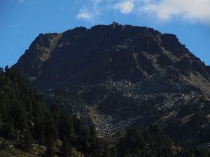 The GR footpath follows the left riverbank. Please note that there is another path to the right, which crosses the river and continues toward the beginning of a gravel road into the valley.
You point towards the left side of a dammed in small lake (HRP 0368B). You have to climb a bit to cross the dam.
You continue downwards to the valley along the river to a historic stone bridge (HRP 0368D P247 3). You pass underneath the pipline (HRP 0368E) of a hydroelectric plant in the valley. You descend further towards a side valley of the RUISSEAU DE SICA, where you cross the river over a stone bridge (HR 0369 P 4 P247 (Signpost)), to follow the river downstream along the opposite bank. You pass the pipeline twice and descend further to a signpost (HRP 0369C), indicating a renewed path towards Hospitalet. This path leads to the N20. As long as this part of the N20 is free of traffic, following this path is a good option. If not, you may prefer to follow the path to its historic end (HRP 0370 P247 5), where you can cross the N20 and return via a minor road to Hospitalet. In the main street, you will find: Gite L’Hospitalite (HRP 0371 P247 6).
Gite L’Hospitalite:
Tel (+33) 674.87.05.05
Dinner (7:30pm):
- Quiche
- Lasagna
- Cheese and dessert
Wine at the table included (cheap French wine, which usually is less good than Spanish)
Many calories, but virtually no vegetables … and that for a lodge in the valley.
Breakfast (8.00am)
Bread, rolls, butter, jam, coffee, tea, cocoa, milk (ask for extra bread!).
Half-board: No recent price indication!
Day 36 HOS P. pres d’ANDORRA – REFUGE DE BESINES |
7 km | +700 | -100 |
Total: without rest: 2:35’, including rest: 2:45′


In fact: a day of rest. Combining it with Day 35 is possible, but then again it becomes very heavy. A combination with Day 37 is also possible, if you continue to Bouillouses on the GR. If you have reserved your overnight stays, this creates some flexibility in your schedule in case of bad weather or other unforeseen circumstances.
You leave the lodge to the left, to continue to the signpost at the bottom of the stairs, which constitutes the beginning of the path to the Refuge de Besines. The first part of the climb is fairly brutal, but becomes more gradual later on.
At waypoint HRP 0371L you cross the N22. On the other side, the path proceeds about 50 meters parallel to the N22, before breaking away from the road and continuing further up. At waypoint HRP 0371M you have a view over the valley and you take a hairpin turn to the right.
Higher up you reach a road (HRP 0372 P253 1 (Coordinates in the guide 80m off trail)), where you turn to the left. 400m further you find the junction (HRP 0372A) between the path to the Refuge de Besines (GR107C) and the Col du Puymorens (GR107), where you turn left.
 At waypoint HRP 0372B, the path turns into the side valley. You cross two streams, to reach a series of cattle gates (HRP 0372E). One kilometer further you reach the dam of the Etang Des Besines (HRP 0373 P253 2). You follow the lake along the southern shore. This place invites to camp, if you can share your spot with the cows. Hikers with low footwear should watch out for muddy patches caused by tributaries.
At waypoint HRP 0373D, you cross a large supply river of the Etang Des Besines, being the Ruisseau de Coume d’Or . 450m further you cross the Ruisseau de Coume d’Agnel via a bridge (HRP 0374 P253 3). Here you commence the final climb to the Refuge de Besines. Just below the hut, you find a signpost indicating the split between the GR10 and the GR107C from Hospitalet. Just behind the hut itself, you will find the signpost to Merens-les-Vals (GR10).
Refuge de Besines (CAF – 2104m):
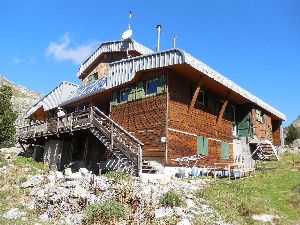
56 beds
Tel (+33) 9 88 77 35 28
(+33) 6 85 77 64 47
Tarifs 2024:
Dorm: 10,50€
Breakfast: 8,90€ (2020)
Dinner: 19€ (2020)
Note: reservations definitely recommended, especially on weekends. Given that the cabin is easily accessible, it is also popular with groups of schoolchildren. At the time of our presence at the cabin, the entire upper floor was occupied by schoolchildren with their teachers and we were referred to the winter room. The sanitary installations downstairs remained closed, so we had to use the bathroom before the morning rush.
Dinner (07:30pm):
- Soup
- Beef stew with mashed potatoes
- Cheese and dessert
Breakfast (08:00am – together with a group):
Bread, cereal, toast, jam, butter, coffee, tea, cocoa (somewhat meager, the end of the season in combination with the quantity needed for a group of schoolchildren?)
Day 37 REFUGE DE BESINES – REFUGE BOUILLOUSES (GR) |
15.5km | +800 | -850 |
Total: without rest: 6:15′, including rest: 6:30′


Alternatives:
-
Refuge de Besines – Refuge Bouillouses via the Cabane de Rouzet and the Pic Carlit: 18,8km – + 1250m -1300m. Strange, unpleasant and steep climb with a risk of falling stones. Whether it makes sense to follow a route along a ridge with a multi-day backpack, remains a philosophical question. It does not make sense to undertake this passage along the ridge in any case other than the most optimal conditions. Pay particular attention to wind and / or rain.
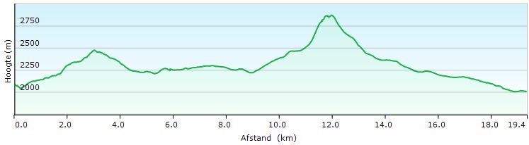
-
Refuge de Besines – Refuge Bouillouses through Porteille de Lanos (HRP 0380A) and the Pic Carlit: 18,1km – + 1250m -1300m. 700m shorter at an equal height difference. The same remarks apply for the Pic Carlit as under 1.

 From the hut, descend to the signpost under the hut, where you turn left. The first part is quite flat and pleasant, and this remains so until you reach the junction between the GR and the variant 2) via Porteille de Lanos (HRP 0380A) and the Pic Carlit. After the junction, it slowly goes up and from waypoint HRP 0376B on, the terrain becomes very rough until the COL DE COUME D’AGNEL (HRP 0377 P256 2).
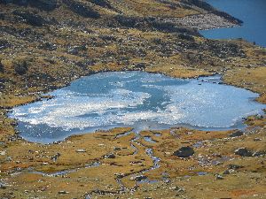 At the COL DE COUME D’AGNEL, don’t be misled by the paint marks on the face of the ridge. You focus on the clearly visible path in the flat part. The path remains flat until waypoint HRP 0377D , and the steep descent to the Estany de Lanoset that stands out through the lush vegetation just below the water surface.
From the outlet of the Estany the Lanoset (HRP 0377E) on, you continue through rocky terrain towards the outlet of the Estany de Rouzet (HRP 0378 P257 1). Hence, you climb slightly up towards the Cabane de Rouzet (HRP 0379 P257 2).
Cabane de Rouzet:

Empty stone building with a steel door. The area is heavily contaminated by users, mainly fishermen.
Those who wish to take the variant in the direction of the Pic Carlit, round the Lac Lanoux in the direction of waypoint HRP 0380 P257 3.
The GR goes up to the wide pass called Portelle de la Grave ( HRP 0379E ). The path is clearly visible in the slope under the col because of the erosion. The climb is very steep and straight.
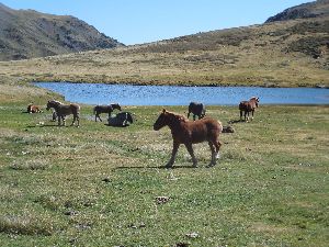 200m past the col, the path takes a distinctive turn to the right and left, to continue further down towards the lake L’Estagnol. The landscape is very attractive. Around the lake, you often find wild horses. The terrain is flat. Shortly after the lake you cross the outlet of L’Estagnol (HRP 0379G).
Then you descend to the main valley of La Grave, where the landscape is also very attractive. After the confluence with the Llosa, the name of the river changes to La Tet. You follow this valley up to the Lac des Bouillouses. The river meanders. You find a path near the riverside and sometimes the path remains slightly higher on the riverbank.
 From waypoint HRP 0379Kon, you will encounter many day trippers on sunny days. You follow the banks of the lake to the dam. Here you will find the Hotel Des Bouillouses (HRP 0385). Then you cross the dam or follow the road just below the dam.
You’ll find a huge parking lot here. Near the lake you will find the AUBERGE DU CARLIT (HRP 0388) and slightly below the CAF Refuge Des Bouillouses (HRP 0387 P260 5).
Refuge Des Bouillouses:
Not property of the French Alpin Club? Hard to find reliable information
Apparently no longer owned by the French Alpine Club. Very difficult to find correct information. Apparently closed for renovation until June 2023.
At weekends and on sunny days often fully booked.
Alternative:
HOTEL LES BONES HORES:
LAC DES BOUILLOUSES
66210 MONT LOUIS
Téléphone: +34 607159518
boneshores66@gmail.com
Tariffs: Half board starting at 65€ individual room, 55€ x 2 for a double room. (2023)
Day 38 REFUGE BOUILLOUSES – EYNE |
16km | +250 | -600 |
Without rest : 3h45 ‘ including rest: 4h00’

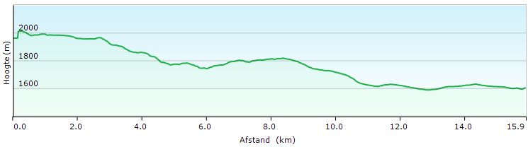
You leave the lodge and walks behind the building. Here you will find the GR footpath that you follow through the forest until you cross the road. Then you cross the river. You follow a faint path on the edge of a flat pasture, with traces of small streams, sometimes resulting in a muddy path.
At the Abri de L’Estany de la Pradella (HRP 0389C), which in reality is being used as a cowshed, the path turns to the right to continue on a road left of the fence.
At the end of the lake you go into the forest and the descent is commenced. In the parts where the road drops sharply, it’s also heavily eroded, with many loose pebbles on the surface as a result. This is very unpleasant. In those parts therefore, it’s looking for a bit of solid ground between the boulders, or a path at the edge of the forest.
From the intersection of gravel roads at waypoint HRP P266 0393 1, this is over. From here on, you follow a path that remains at the level and which is easy to walk on.
At waypoint HRP 0393B, you encounter a signpost and less than 50m further, you leave the gravel road for a declining path, which evolves at the back of the gardens of skiing holidays in the ski resort Super-Bolquère.
 Just before the D618 (HRP 0395 P260 3 D618-D10 C), you reach the asphalt. You cross a main road, to follow the smaller D10C downhill for 1km. Shortly after a sharp turn to the right, you leave it to the right along a path that cuts short a hairpin turn. In the end section, the path is muddy. At waypoint HRP 0396A, you cross the D10C to continue straight ahead until you reach waypoint HRP 0396B . From here on, you follow the D10C again to the entrance of Bolquère. At the crossroads, turn left and take the lowest road (Rue Du Stade) and then the Rue du Ruisseau. At the end of it you’ll be back on the D10C, which you follow to the left to Traverse de L’Ecole (HRP 0397C). Here the GR leaves the D10C to make a detour of 900m, to return to the D10C at the Station of the Yellow Train (HR P 0398 Sncf: Bolquère-Eyne). That way, you miss the info panel on the GR10 at waypoint HRP 0397D. So it’s easier to just continue to follow the D10C to the Col de la Perche (HRP 0399 P266 5).
Here you leave the GR10 which goes to the left. 100m left on the N116 you will find the Hotel Le Catalan (HRP 0399A).
Hotel Le Catalan :
- Col de la Perche
- 66210 La Cabanasse
- 04 68 04 21 83
- contact@hotel-lecatalan.com
Double room: 79 à 99€ (2024)
Half-board: € 57
Follow the road straight ahead and follow the D33 over a distance of 3km to the village Eyne. The Gite du Presbytere is reached by taking the road up to the left at bifurcation at the entrance of the village, to continue until you reach the church tower.
Gite du Presbytère – Gites Cal Pai :
Carrer del Ventador,
66800 Eyne
bonjour@gite-calpai.com Tel (+33) 608.82.00.99
Half board: 85€ individual use – 70€ x 2 (double room) (2024)
Contrary to what is stated in the guide and on the website, no meals are provided here outside the ski season. It is obvious that these refuges make their money during the winter season and that occasional HRP hikers are tolerated , but they shouldn’t expect any extra’s. (current situation to be checked by mail!)
Those who arrive between Friday and Sunday, can find something to eat in the bar / restaurant (HRP 0400A) at the car park at the end of the village. At noon, on the days mentioned, you can obtain lunch. In the evening you can just get tapas. Those who pass here during the week, will have to bring meals from the FOOD STORE in FRONT of the POST (HRP 0397A) in Bolquère and prepare this in the kitchen of the lodge or move to the above mentioned Hotel Le Catalan. This prolongs the next day’ stage with 3km.
Two messages were sent to the mailbox of www.gite-calpai.com but they were never answered.
Overnight stay at the Presbytère: In the evening no one was at home at the gite Calpai (which is also the home of the owners, and which is accessible by climbing the metal stairs at the outside of the Presbytère.)
Restaurant (2015):
Dish of the day : Belgian (yes) stew with fries : € 10,90
Glass of wine: € 1.80
Various (Belgian) beers available.
Store at the bar:
Bread: € 1.80
Jam: € 2
Canned Ravioli: € 2.10
Info Point next to the bar:
Bottle of organic wine: € 8.10 to 9.90
Day 39 EYNE –REFUGE ULL DE TER |
19.5km | +1700 | -1050 |
Total: without rest: 6:30’, including rest: 7:30’


You leave the lodge to the left, to climb a few meters uphill, after which you descend towards the D33. You follow the D33 to the left over a distance of 200m and cross the river there. 50m further you leave the road to the left, over a gravel road. 150m further you leave the gravel road to the right. The route is marked with wooden signposts, with green signs. 250m further, you turn right again. 500m further you reach a gravel road, which you follow to the left. 250m further you reach a coral. You round the coral and do not descend to the Coma d’Eina, but remains at the level along a path.
750m further you cross the Mas Rondole (HRP 0403 P268 3). You leave the forest and continue your way up in pastures. An information panel cautions you to be aware of the cattle. At an altitude of 2050m you notice the Refuge de L’Orry Baix (HRP 0404 P269 1) on the other side of the river. 300m further, at waypoint HRP 0404A and a small waterfall, you circumvent a small hill near the river to the right. You can also continue to follow the river, to return a little further back to the main track, at waypoint HRP 0404B, along a steeper path.
 At waypoint HRP 0404C cross you a major tributary of the Coma d’Eina and continue between the two branches up to waypoint HRP 0404D, where you find a clear path again. At waypoints HRP 0404 E and HRP 0404F, you cross two smaller tributaries.At waypoint HRP 0404H makes the path a distinctive turn to the right and left, to continue to climb along a heavily eroded path towards the COL D’EYNE (HRP 0405 P269 2).
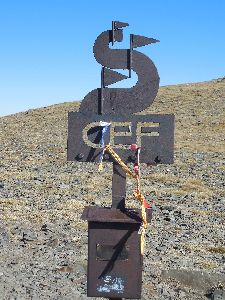 Except for a few posts that indicate the limits of the Reserve Naturelle de la Vallée d’Eyne state, you won’t find any way marks. Here you go on sight to the Pic d’Eyne (HRP 0405A) off trail at the beginning, but higher up you’ll find a path.
At the Pic d’Eyne , turn right and descend slightly to a saddle between the Pic d’Eyne and the Pic de Les Nou Fonts (HRP 0406 P269 3), to continue to climb to the Pic de Les Nou Fonts itself. At waypoint HRP 0405B, you find a metal post with a metal box (CEF) containing the summit book. The cairn indicating the actual summit is a little further. Just before this cairn, you find a path that leaves ridge to the right. The first part is somewhat steep and technical, but in the lower section, the path becomes easier. You descent further to the Coll de Nou Fonts (HRP 0407 P269 4), where the GR11 from Nuria joins the border ridge. A little above the pass, you find the Abri Coll de Nou Fonts. The white-red markings are confusing around here.
 You will find both a path along the French side (easier) and one along the Spanish side (more difficult). The Spanish path crosses a small top on the ridge at waypoint HRP 0407A, where the French variant goes around this top. Both paths come together again at waypoint HRP 0407B. You persecute along a path beneath the Pic de Noucreus (HRP 0407C), in the direction of the COL DE NOU CREUS (Col with the Nine Crosses) (HRP 0408 P269 5). From the Col, the path goes down towards the Col de la Vaca (HRP 0408B), recognizable by the signpost to the Refugi Coma de Vaca (ca. 2000m – 1:22′) .
 From the col on, you climb back up towards the highest point on the western ridge of the Pic de la Vaca Inferior (HRP 0408C). You round the Pic along the south side, to leave the border ridge in a southerly direction to the COL DE TIRAPITZ (HRP 0409 P272 1). On the other side, you descend towards the junction at the Cabana de Tirapits (HRP 0409A) and the path underneath the Cabana de Tirapits (HRP 0409B).
From here the path goes down in a southeasterly, easterly and later northeasterly direction. You cross a stream twice. At the second crossing, (HRP 0409D El Freser), you’ll also find a painted signage to the Refugi Coma de Vaca (about 2000m). From here on, you follow the path in the flank up to the COLL DE LA MARRANA (HRP 0410 P272 2). Especially? Te path downhill is special. The white-red way marks follow a route through a few bolder field just below the col. However, there is also a path that a makes a clockwise bend of 180°, against the flank of the mountain and to continue down towards the cirque. In the cirque, the visibility of the path is rather vague until you arrive at the Refugi Ull de Ter (HRP 0411 P272 3), because of the presence of a ski slope.
Refugi Ull de Ter:
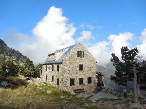
52 beds
Tel (+34) 972.192.004
(+34) 619 514 159
H/P: 55€ppn (2024)
(open from mid-June to mid-September, then only on weekends or for a minimum of at least 8 people, at other times).
If not open, you can enter the open hut: Refugi Lliure, it being the winter room of the Refugi Ull de Ter (HRP 0411A – free – mattresses, blankets, table and a few chairs, water point at the bottom of the main lodge, food: self providing)
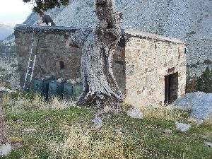

What was really irritating is that the proprietor was actually present to do some work at the hut, but apparently didn’t have the commercial feeling to receive us at the main building :-(((.
Day 40 REFUGE ULL DE TER – REFUGE MARIAILLES |
22km | +600 | -1100 |
Total: without rest: 6:30’ including rest: 7:00′


You leave the hut and passes underneath the main building and along the trough with the water tap. You descend along the trail that ends at the asphalt road to the ski resort Vallter 2000 in a hairpin bend (HRP 0411D), where you turn left. In the next bend in the road, near a stream, you already have the possibility to cut short via a steep path towards the upper hairpin bend. You can also do this at the next hairpin curve, or just follow the asphalt road up.
Once up at the parking lot with the buildings of the resort, you have to pass behind the actual buildings. There is a vague dirt road going up in the pasture. The road ends to continue as a path. The first white-red way marks, you’ll find at waypoint HRP 0411E.
You climb up along the path that is initially heavily eroded. After fording the Torrent de la Portella (HRP 0412A), the path becomes substantially better. At waypoint HRP 0412B you are up on top. Here the Spanish white-red are replaced by the marking colors of a variant of the GR11, being the yellow-red of the French Tour du Canigo (RC) or the Tour de Réserves (TR).
At waypoint HRP 0412C, you notice towards the right, a path which slightly climbs up along the mountainside and which forms an unmarked shortcut on the official path. The marked trail continues briefly straight ahead towards the Porteille de Mourens (HRP 0413 P273 2), where you’ll find a signpost to the right. At waypoint HRP 0413A, the short cut rejoins the main trail. Then the path turns southeastwards. At a river dry bed (HRP 0413B), the trail continues in a northeasterly direction. You go to a highest point (HRP 0413D), where you go to the right (HRP 0413E). At the Porteille des Caillau (HRP 0413F), you find a post that marks the boundary of the Reserve Naturelle de Mantet. Over here, you don’t go up steeply towards the Roca Colom (HRP 0414A). Instead you follow the highest path in the flank towards the open col, PORTEILLE DE MENTET (HRP 0415 P276 1).
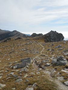 At waypoint HRP 0414C you’ll find the last and at waypoint HRP 0415A the first way mark on the grounds surrounding the PORTEILLE DE MENTET. From the PORTEILLE DE MENTET, the path is somewhat vague. You go from the French side of the Spanish side, to return to the French side at the PORTEILLE DE ROTJA (HRP 0416 P276 2). OSM track log is inaccurate here. You will certainly through the cattle gate at the PORTEILLE DE MENTET towards France. On the French side you will see a signpost in the scree (HRP 0416A). You descend towards it, and continue at the bottom of the slope, to return to the border ridge. You reach the PORTEILLE DES AVETS (HRP 0417 P276 3).
You’ll leave the border ridge again, to pass a partially wooded and rocky shoulder along the French side (HRP 0417A) , where progress is quite difficult. At the COLLADE DES ROQUES BLANCHES (HRP 0418 P277 1), you return to the border ridge. Here you follow the slightly uphill gravel road, which is not very pleasant to walk on, given the many loose rocks on the surface of the road. At waypoint HRP 0418A, you reach the highest point. Then the road goes back downhill towards COLL DEL VENT (HRP 0419 P277 2) .
From the col, you follow a heavily eroded trail uphill again towards waypoint HRP 0419A , where the terrain flattens and the trail fades in the landscape. A faint trail leads you to a signpost (HRP 0420 P277 3) at a crossroad on an otherwise barren plain (PLA GUILHEM).
At the signpost, you turn left and the way marks change from yellow-red into the white-red of the GR10. You cross a dry riverbed (HRP 0420A), to continue in a northwesterly direction. Strangely, the cairns follow a course at some distance from the track on the ground. You pass at some distance from the Refuge de Pla Guillem (stone unmanned hut, no water – HRP 0421 P277 4). Along a ridge, you descend towards the CROIX DE LA LLIPODERE (HRP 0422 P277 5), where you reach a gravel road. You cut short the hairpin bends in the road along a heavily eroded path until you reach a gravel road again waypoint HRP 0422B. You follow it to the left toward an intersection of gravel roads (HRP 0423 P277 6 (coordinates in the guide nearly 450m off trail)). Here, you continue to descend further towards the Refuge de Mariailles ( HRP 0424 P277 7 ) .
Refuge de Mariailles:

55 beds
refuge.mariailles@gmail.com mjordronneau@wanadoo.fr
Dinner (7:00pm):
-
Split pea soup
-
Sausage and mashed potatoes
-
Cheese, dessert
Breakfast: (06:30am)
Bread, biscuits, butter, jam, coffee, tea, cocoa
Half board: 47,00€ (2024)
Shower 5’: 3,00€ (2024)
Reservation: € 15 (in advance)
Day 41 REFUGE MARIAILLES – GITE BATERE (without Canigou) |
26km | +1450 | -1700 |
Total: without rest: 9:00′, including rest: 9:30′

Concerns regarding route and stage choice:
As previously mentioned, I’m not a fan of the inclusion of peaks in the planning of a long and difficult trek itself, given that the level of difficulty only increases.
For those whom wants to undertake an attempt to reach the summit of Canigou, can do this only safely in good weather, and preferably with a not too heavy backpack. It is advisable to split up this stage in two, with a night at the Refuge des Cortalets. That way, you also have two days, at which you can attempt to reach the summit, depending on the weather conditions.
Three possibilities:
-
Day 41 REFUGE MARIA ILLES – GITE BATERE (without Pic Canigou, but along the ridge): 26km + 1450m -1700m: Clearly the shortest distance in length in combination with the smallest height difference. When the mistral doesn’t blow you of the ridge, this is the only option that is sufficiently easy to complete in one day. Know that the highest point on the ridge is just 70m below the Pic. If you pass over the ridge at a time when the Mistral blows, you may have to deal with wind speeds of over 120km/ h and a wind chill factor that feels far below freezing. If you pass here in such conditions with summer gloves on or without any, you will be faced with the onset of frostbite, at the end of a descent of almost 250 altimeters, executed at a light running pace. In such circumstances, you really do not want to pass over the Pic du Canigou itself, where the technical conditions, especially in the climb from the Gite de Batere are harder, resulting in a slower pace and therefore a bigger risk of severe frostbite.
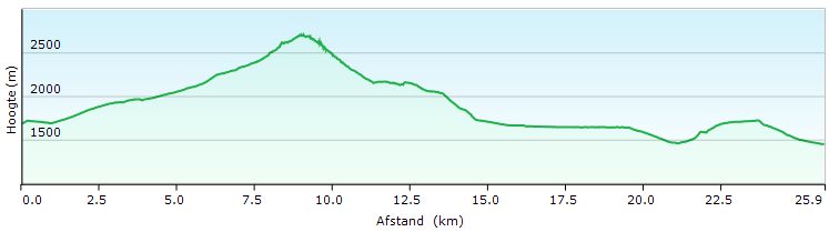
-
Day 41 REFUGE MARIA ILLES – GITE BATERE (Pic Canigou): 27,5km + 1450m -1600m: 1.5km longer than the ridge route, with an additional height difference which is negligible. The technical difficulty is mainly higher in the climb, so you’re longer exposed to the elements. Only in the most ideal conditions and preferably in combination with a night at the Refuge des Cortalets .
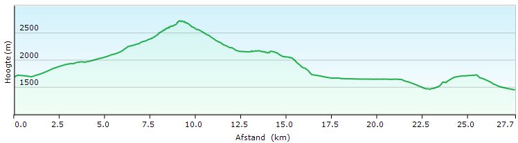
-
Day 41 REFUGE MARIA ILLES – GITE BATERE (without Pic Canigou, but along the GR10 ) : 31km +1750m -2000m: Clearly the longest variant, with the highest altitude difference. This variant however does not exceed 2250 altimeters, making it the safest route in bad weather.

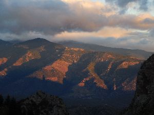 You leave the Refuge de Mariailles, to climb back to the signpost at the parking lot (HRP 0423 P277 6). There you take the descending path towards the Canigou. You descend towards the river, Llipodere, which you cross by a bridge ( HRP 0424B ). Then you commence the slow climb towards the Canigou. At waypoint HRP 0424C you cross a first periodic stream. Further on you cross the main river in this tributary valley at a ford on the river Cady (HRP 0424E). The course of the path here is fairly unpredictable. On the other side of the river you can see a wall. Follow the path up on the wall to the left. 600m further you reach the junction between the GR10 and the path to the Canigou. Refer for the variant along the GR to point 3 above.
 Leave the GR 10 to the right and continue your climb towards the Canigou. After 1 km you reach the Refuge Arago ( HRP 0426 ). This refuge was rebuild in 2015. You can also pitch a tent near the hut. The next part is the path difficult to follow because of the bushes. A kilometer past the hut, you cross the river Cady again (HRP 0426A). At waypoint HRP 0426B you reach a shortcut, which more clearly visible than the original path. At waypoint HRP 0426C you’re back on the original path.
At waypoint HRP 0426D, you reach the foot of the wall. Higher up, you can find a source (HRP 0426E). The path is in good condition.
At waypoint HRP 0427 P279 2 you reach a junction, which is only indicated by painted way marks on a relatively small stones. The lowest path leads you to the Pic de Canigou.
The highest path leads toward the Porteille de Valmanya ( HRP 0427A ) and then towards the ridge. Refer to the observations formulated under paragraphs 1 and 2.
Along the highest path you safely reach the Porteille de Valmanya and from there on, you can see the path in the side of the ridge towards the highest point on the ridge (HRP 0427B) .
In case of Mistral, this part can be dangerous, in view of the fact that the path descends closely against the edge of the ridge, over a distance of 250 altimeters. You leave the edge of the ridge at waypoint HRP 0427C and descends in a northerly direction. Once you reach the wooded section of the hillside, the path is less defined due to shortcuts. At waypoint HRP 0430A, you return back to the GR 10. The Refuge des Cortalets, you can reach by going 300m to the left.
Refuge des Cortalets (CAF) :
112 beds (open from late May until mid-October ) Reservations recommended.
Tel (+33) 468.96. 3 6 . 19 (hut)
Dorm: 12,22€
Half board: 38 +12,22€ (dorm) (members)
Those who wish to continue towards to the Gite de Batere, turn at the junction with the GR10 to the right. The trail runs at first at level in the flank. After a right turn, you commence the descend. Then follows a flat section through a rocky slope. Further on the path descends again, to turn south.
You pass a gate (HRP 0430B) in a fence and continue your way in the same direction until waypoint HRP 0431 P282 3. Here, the path makes a hairpin bend, to return north. Again you reach the fence, which you follow in the descending direction. At waypoint HRP 0431B, you pass through a gate, and you descend further down along the other side of the same fence. At a height of approximately 1700m, you reach the gravel road to the Refuge des Cortalets .
You leave this road immediately to the right through a gate in the fence. You follow a path at the same level in a westerly direction until you cross consecutively two feeder rivers of the Lentilla at the end of the valley. 150m further you cross a third one. You remain about 3km at the same level, during which you have to cross multiple periodic streams. After 2.3km, you pass the Refuge Pina Tell (HRP 0431J).
Refuge Pina Tell:

In 2015, a warning against bedbugs in the cabin was stapled to the door.
After the periodic stream at waypoint HRP 0431K, you commence the descent to the MAISON FORESTIERE DE L’ESTANYOL (HRP 0432 P283 1) below.
Maison Forestiere de l’Estanyol :
 Large stone hut, part of which is accessible to the public.
From the hut you ascend slightly over a distance of 500m. Along the way you pass two signs: the first is a single signpost to Valmaya, the second is a multi signpost, where you take the direction Batere.
Near the river you switch to a zigzag path along which you gain about 200 altimeters, until this cross the river at waypoint HRP 0432E. Then the path flattens out again and you continue to walk at almost the same level in the direction of the COL DE LA CIRERE (HRP 0433 P283 2 – Signpost). From the col, you descend, first along a path, which evolves in a gravel road, and into an asphalt road for the final stretch towards the GITE D’ETAPE DE BATERE (HRP 0434 P284 1).
GITE D’ETAPE DE BATERE:
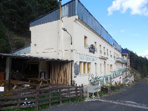
38 Beds
Lieu-dit les Mines de Batère – 66150 CORSAVY
contact.refugebatere@gmail.com
Tel (+33) 468.39.12.01
Dinner (7:30pm):
-
Rillettes with lettuce
-
Tartiflettes
-
Lost bread
-
Coffee or tea included
Breakfast (6:45am):
Cake Bread, bread, jam, butter, juice, coffee, tea (plenty)
Half-board in communal room: € 46 (2023)
Day 42 GITE BATERE – LA FARGASSA
|
18km | +850 | -1600 |
Total: without rest: 6:15′, including rest: 6:45’


This stage is completely GR10 marked. You leave the lodge to the left to descend slightly along the asphalt road until the first hairpin bend. Here you leave the asphalt straight on along a path that initially descends near a stream (Descarga). After 500m you leave this stream, and you continue to descend along the edge of a forest zone in the direction of a gravel road (HRP 0435 P287 2). Here, you can find a kind of alternative community, a collection of vehicles, tents, structures and gardens.
The GR markings are vague in this zone. You walk in a southerly and not in a westerly direction (to the right). Only at waypoint HRP 0435A you find a GR way marker again.
You follow the gravel road through the forest over a length of 1.5km. You leave it at the third hairpin bend for a path. 200m further, you pass the ruin of the Refuge Des Vigourats (HRP 0437 P290 2). You descend about 100 altimeters, to cross the Descarga or Freixe (stream) at waypoint HRP 0437B.
 You climb out of the gulley of the stream, to reach a gravel road (HRP 0438 P290 3), which you follow to the right. 500m further you cross a periodic flow (HRP 0438B), after you reach a T-junction (HRP 0439 P290 4). Here you turn to the right. 700m further, you leave the gravel road for a path (HRP 0439A). You descend towards a gravel road again (HRP 0440 P290 5) at which you turn to the right, to reach the ruins of an intermediate station of the funicular between the Mine Batere and Arles-sur-Tech. You descend 250 altimeters on a ridge with rough stones. At the entrance of the forest, you pass a signpost to an ancient lime oven (HRP 0440A).
 600m further you reach a gravel road (HRP 0440 P290 5). Abandon this road again at waypoint HRP 0440A, to descend through the woods in the direction of Arles-sur-Tech (HRP 0441B (Start of asphalt road – signpost)). Turn left and at the next intersection turn left again. You pass through the Rue des Ecoles, at the end of which you find a bench under the trees. Then you pass through a backstreet (Traverse Albert Rouge) parallel to the D115. At the end of it, you still follow the D115 to the left over a distance of 80m to the Passage de la Coquinière, which you enter to the right, to follow it along its entire length to the old train station (HRP 0443 P290 8 D115). You continue in the same direction, to follow the Rue du 14 Juillet until the bridge (HRP 0443A) across the river.

Hotel Les Glycines:
7 rue du Jeu de Paume, Arles-sur-Tech, France
Tel: +33 4 68 39 10 09
Kamer: starting at 80€ (2024)
Cheaper alternative via Booking.com:
Maev’Arles (41€ – 2024)
On the other side you will find a signpost (HRP 0443B). You make a turn to the right, to enter a grove. You do not follow the central axis, to climb against the right ramp and then up through a gate. There you will find a better path, which you follow to the left to a concrete road. This you follow to the right, to leaves it after 100m to the left through a gate. After 100m you again reach a gate, where you commence the climb along a kind of natural stairway of nearly 400 altimeters. You reach a kind of faux col (HRP 0443H ) , to climb in a more natural way to the COL DE PARACOLLS (HRP 0444 P290 9 – Signpost). The path stays more or less at level until you reach the ruin of a house (HRP 0445 P290 10), after which the descent is commenced to the ford at the Terme (HRP 0445C). Then, you turn left, towards the first building, which is the ECOGITE DE LA PALETTE (HRP 0446 P291 1) The second building is a kind of commune, attached to the Ecogite. 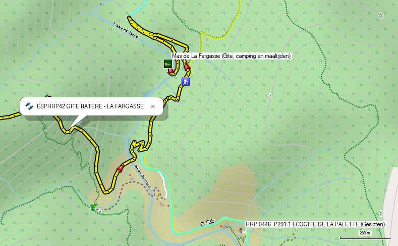
Ecogîte DE LA PALETTE (Closed):
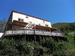
Alternatieve 1:
Mas de la Fargassa:
(ecological vegetarian holiday spot for families, but also gite HRP/GR11 after closure of La Palette)
lafargassa@gmail.com
Tel: 0033(0)468390115
Satellite tel : 0033 (0) 972515541
Dorm: € 22, –
Tent: € 12, –
Diner: € 20, –
Breakfast: € 12, –
Picnic: € 14, –
Alternative 2: use GR trail via Amélie-les-Bains (GR)
Day 43 LA PALETTE – LAS ILLAS |
18km | +1100 | -1200 |
Total: without rest: 6:30’, including rest: 7:00′

If you like to stay close to the original route, leave the gite and return to the asphalt, which you follow to the right. You leave the road approximately at the height of the gite on the asphalt (HRP 0446A) for a path on the left that goes up the mountainside. It is a typical path that follows the contours of the landscape, while remaining mostly at level. At waypoint HRP 0446C, you cross a periodic flow. At waypoint HRP 0447 P292, you look down on MONTALBA .
Then the trail climbs about 200 altimeters, to remain at level until you reach a gravel road. You follow it to the right, to cross 2 periodic streams. You continue to climb along a more overgrown and climbing gravel road. In the second hairpin bend you find the ruin of the MOULI SERRADOU (HRP 0449 P293 1). The road narrows into a path and continues to climb up to the COL CERDA (HRP 0450 P293 2).
Shorter alternative:
You can also continue to follow the asphalt until it turns into a gravel road. Here you will find a forest road that rises slowly until you reach a bridge over a tributary. Here you leave the forest road for a path that remains on the same bank and continues to climb until the COL CERDA (HRP 0450 P293 2). Here you go to the right.
You descend from the col, to pass several cattle gates. At waypoint HRP 0451 P293 3 (Coordinates in the Cicerone guide are around 220m off trail!), the GR leaves the border grate for a technically easier path along the French side.
 The Cicerone guide will send you further up along the ridge along a yellow-marked route. You have to improvise much, to reach the Roc de Frausa ( HRP 0452 P296). From the top you descend towards a mast (HRP 0453 P296 2), and then along the French side towards the COL DU PUITS DE LA NEIGE (HRP 0454 P296 3).
The GR10 descends from the ridge in the direction of a crossroad (HRP 0451A). At this intersection, the French HRP variant passing over AMELIE-LES-BAINS joins the border ridge again. Here, the GR10 makes a hairpin turn and climbs back about 25 altimeters, to continue underneath the ridge with the Roc de Frausa, to reach the COL DU PUITS DE LA NEIGE (HRP 0454 P296 3). Underneath the col the path becomes somewhat vague, but technically there are no difficulties in the terrain. You walk on sight towards the col.
At the COL DU PUITS DE LA NEIGE, there are again two possibilities:
-
Follow the GR10. This path follows the contours of the mountainside to arrive at D13F. Follow this road to the right towards Las Illas. This variant is 3km longer than the route along the Spanish side.
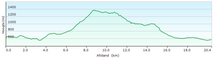
-
At the COL DU PUITS DE LA NEIGE, you can change sides on the border ridge through a gate with a cattle roster. On the Spanish side you will find a signpost to Les Salines and Coll de Lli. You descend slightly along a path in a southeasterly direction. After 700m you reach a cabin with room for 12 people, which is always open and is useful when the Refugi de Les Salines is closed (HRP 0455A – Open Thursday through Sunday). There is also a source (HRP 0455C Font de la Cova).
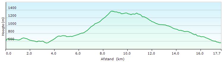
Turn right in front of the car park. 50m turn left and after 150m you cross the Riera de Les Salines ( HRP 0455D ). 700m further you reach a gravel road, where you turn left. A bit further, you reach the Coll de Cordes ( HRP 0455f ).
You descend from the col in an easterly to southeasterly direction. At the height of the ruin of the Castell de Cabrera (HRP 0455G), the road follows the contours of the landscape, first northwards and then eastwards. You descend further towards COL DE LLY (HRP 0456 P296 5).
At the col, you cross the border again and descend in a northerly direction. At waypoint HRP 0456A, you reach a gravel road, along which you descend to the right towards Las Illas. Just beyond the parking lot, you will find the Hostal Dels Trabucayres (HRP 0457A). The gîte d’étape (HRP 0457 P297 1) appears to be closed.
Hostal Dels Trabucayres:

Tel (+33) 468.83.07.56 (Opens at 16.30u)
(+33) 4 68 66 55 38
Rooms with communal bathroom facilities. The rooms at the back of the hostal, have a terrace.
No recent tariffs online!
Day 44 LAS ILLAS –COL DE L’OUILLAT |
23km | +1050 | -650 |
Total: without rest: 6:00′, including rest: 6:15′


You leave the inn and walk down the main street to the north. At the end of the village, you will find the way marks of the GR10, which follow further the D13 northwards.
The GR10 follows D13 over a length of nearly 3km, to leave it using a gravel road leading towards the border ridge. This variant is 1.5 km longer than the route described below along the border ridge.
At at the end of the village of Las Illas, you can turn to right and climb in a zigzag along the Route de Manrell ( HRP 0457B ) towards the COL DE FIGUER (HRP 0458 P300 1). At this pont, you have already conquered the highest altitude difference. You continue to follow the gravel road along the natural border ridge. At waypoint HRP 0458B you join the GR10 again, which you follow up to the COL DE L’OUILLAT (HRP 0469 P302 2).
250m further? you cross a brook (HRP 0458C). Another 250m further you pass a farm (HRP 0459 P300 2). 600m further again, you reach a fork at a wooden hut (HRP 0460 P300 3), where you turn to the right. At waypoint HRP 0460B you reach the highest point. From here, you mainly descend to the exit road (HRP 0461 P300 4) to the D13 and Maureillas-Las-Illas. However, you will continue to follow the natural border ridge to the COL DEL PRIORAT (HRP 0462 P300 5).
500m further you leave the gravel road quite suddenly along a path ( HRP 0462A P300 6) that goes to the right in the forest. Only two painted white-red Andreas-crosses mark this change of direction. The path ends at a paved green cycle path, that you follow to the right. You pass the Site de Panissars (HRP 0462C), where the hardened surface of the cycle path is replaced over a short distance by gravel. At the Cimetiere de Panissars (HRP 0462E), the road bends to the right and then climbs towards Le Perthus (HRP 0464 P300 8). Along the way you have pass the exit to the FORT DE BELLEGARDE (HRP 0463 P300 7).
The town of Le Perthus is completely dominated by the presence of the viaduct of the A9 motorway. The GR10 reaches, the old main road N-II or D900 and follows it to the left until you reach the big parking lot. Here you leave the main road to the right and pass underneath the motorway.
The Cicerone guide sends you here up the D71 over a distance of over 4km, before you leave it for a path at waypoint HRP 0465 P301 1, marked by a signpost. You climb towards SAINT MARTIN DE L’ALBERE (HRP 0466 P301 2), where you return to the D71. At waypoint HRP 0467 P301 3, you leave the D71 again, to cut a hairpin bend in the road. Once you exit back to the way it back to the left again to stabbing a hairpin. At the Col El Rat ( HRP 0467B ) you definitely rejoin the GR10 to the COL DE L’OUILLAT ( HRP 0469 P302 2 ). The added value of this route choice is totally incomprehensible, because it is neither shorter nor easier, and eventually returns to the GR10.
The GR10 itself, leaves the D71 to the right along a gravel road, just past the A9 viaduct. The gravel road ends at the border. At waypoint HRP 0464E, you can find a signpost at the beginning of a vague path. You follow this up until it opens onto another sort of road, which is easier to follow until you reach waypoint HRP 0464I . From here on, you will find a path toward the border pass. Once across the border, the trail widens and flattens. At waypoint HRP 0464L you arrive at a real gravel road, which you follow as close as possible to the border ridge. At waypoint HRP 0464N you slowly turn away from the border towards the Ruisseau de L’Albere (HRP 0464S).
You climb next to the river along a narrow and steep path up to a hairpin bend in the D71. From here on, the GR follows a narrow path parallel to the same D71 and this up to the Col El Rat (HRP 0467B). From the col, you follow a heavily eroded path through an area with grass and low shrubs. At waypoint HRP 0468 P302, you find a large cairn. You continue in the same direction towards waypoint HRP 0468B, where you leave wide eroded trail through the open section for a path in the direction of the woods. Once in the forest the path remains at level and is more clearly defined. After 800m you reach the COL DE L’ OUILLAT and the Chalet de L’Albère, located over there.
Chalet de L’Albère:
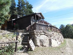
Tel (+33) 468.83.62.20
Half-board: € 46 (2024)
Upon arrival we were informed that there would live music on Saturday night, with possible noise hindrance. We were housed in the bedroom, which is farthest away from the restaurant to minimize the nuisance. Moreover, the overnight half-board rate was reduced. (The half liter of red wine at lunch was not charged.
Book therefore certainly on the weekend and do not allow you to be forward to the Refuge de la Tagnarede, which is a pretty dirty place with zero comfort.
On weekends with nice weather, many guests come here to enjoy the view and the food.
Dinner (7:30m):
-
lettuce
-
Pork cheek with pasta
-
Dessert.
Breakfast (7am): Toasted bread (ask for additional bread), jam, butter, coffee or tea, fruit juice
Day 45 COL DE L’OUILLAT – BANYULS-SUR-MER |
23km | +850 | -1700 |
Total: without rest: 6:00′, including rest: 7:00′

You leave the cottage to walk towards the road. At the end of the fence, you return in almost the same direction to climb up the steep slope to the border ridge, the COL DES TROIS TERMES (HRP 0470 P303 1). The GR markings lead you to the pass itself, but you can just as good as well follow road just below the ridge until the mast at the Pic Néoulous (HRP 0471 P303 2).
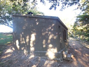 GR returns to the asphalt road. You round the transmitter and then descends, first through the woods and then along an open section to a saddle (HRP 0471B).
Descend not entirely down to the gravel road, but find an initially vague path to the Refuge de la Tagnarede (4 beds – unmanned – quite dirty – HRP 0472 P303 3).
From the refuge you return to walk a little closer to the ridge. You pass the border stone 585 (HRP 0473 P303 4). You turn in a northeasterly direction and head towards some sort of Col (HRP 0473A). The track here is vague by the lack of cairns .
At waypoint HRP 0473A, you leave the ridge and round the Puig de Pradets (HRP 0473B) on the French side. Just before returning to the pass (HRP 0473D), the path is vague in the forest. Once at the border ridge, you leave it immediately to round the Pic Dels Quatre Termes (HRP 0474 P303 5).
After Pic Dels Quatre Termes you return briefly to the border ridge. The OSM track log leaves the ridge, but you can also continue along it over a distance of approximately 500m. You keep walking in the treeless zone around the border ridge, while rounding any obstacle. At waypoint HRP 0474H, you leave the border ridge again, to round the Pic de Sailfort (HRP 0475 P303 6). On sunny Sunday’s, the Col is packed with picnickers.
You descend from the col. At waypoint HRP 0476 P303 7 (Exit to the Coll D’En Verderol), you stay on the ridge and ignore the path that goes down to the valley. At waypoint HRP 0476B you ignore the exit to Rimbau. At the COL DE BAILLAURY (HRP 0477 P303 8), you find the vehicles of those who are too lazy come to the mountain on foot.
 Then you start your last climb of the HRP, namely the COL DE FORMIGOU (HRP 0478 P303 9). From this col, you remain at level to the COL DES GASCONS (HRP 0479 P307 1). You find a signpost, which indicates the shortcut of a hairpin bend. The trail is quite steep and eroded. Be careful is the message. At waypoint HRP 0479C, you return to the asphalt road. You follow it downhill towards the COL DES LLAGASTERA (HRP 0481 P307 3). There, you leave the asphalt for a gravel road, which you follow in an easterly direction. The road alternates with stretches of path, which cut short the curves. At a crossroad, at waypoint HRP 0481E, you turn left. It seems way marks were erases here on purpose. Descend to the road (HRP 0482 P307 4) and cross it into a tributary street. At the next intersection (HRP 0482 P307 5), you turn right. You descend further towards the railroad track. At waypoint HRP 0484 P307 6, you reach the asphalt, to pass underneath the railway through a tunnel. At a T-junction, you turn left. At the next T-junction at a small square, you turn left, to continue in the original direction. In the square at the coastal road, turn right towards Town Hall.
 Here, you’ll find the signpost made of ceramic tiles, indicating the end or the beginning of the GR10. Depending on the weather, you can wash your feet in the sea or go for a complete dive. At the public beach, you are free to go far into the water to swim, because the depth increases only slowly. Wading shoes are advisable. You can use the beach showers and free public restrooms to change clothes. A snack can be found at Snackbar La Ganotte (HRP 0486C).
At 8:00pm the night train to Paris passes at the station in Banyuls-Sur-Mer (HRP 0486D). The station can be reached via the Avenue de la Gare.
Coordinates: