Travelogue on the HRP West
The most recent version of this page can be found at https://roversmountains.com/hrp-english/ !

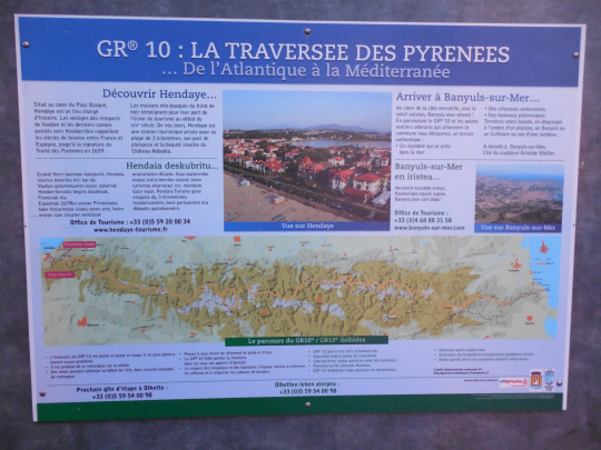
Pyrenean Haute Route (Hendaye – Bagnères de Luchon).
Countries: Sometimes literally on the border of France and Spain
Région: Pyrénées Atlantique, Hautes Pyrénées, Pais Basquos, Aragon
Traject: Hendaye – Bagnères de Luchon
Period: from 26th June 2014 until 18th July 2014 (Updated 2024)
Travelling companions: I left solo for the first two weeks. Rather late in my holiday planning, I agreed with a family member to join me in Gavarnie. Gavarnie is situated in the Central Pyrenees which means you are immediately in a high altitude region. Therefore it is reasonable to assume that there will be a difference in the condition between someone who is already two weeks underway and somebody who arrives by train from sea level. And so I gave up the planned rest days, that were specified in my first schedule for a slower start from Gavarnie.
During the first two days after my departure, I regularly met two Scots and one Australian along the way. The latter soon realized, I navigated less effortlessly with my GPS, instead of him with his pile of cards. So he decided it was easier to follow me, for the next full three weeks 😉.
Public transportation:.
To:
Return:
- Bagnères de Luchon – Toulouse
- Toulouse – Lyon (at least 30′ delay as a result of an accident)
- Lyon – Brussels Midi (about 2:00′ overall delay because of the accident. I was diverted to Lille, because we missed the connection with the last train to Brussels and I slept in Lille at the expense of the SNCF) (afterwards received a “compensation” of € 63.80 for the delay, this in coupons, which are valid for one year on your next trip, within a year’s period.
- Brussels South – Any station
Accomodations:
- Mountain huts not owned by the CAF (Club Alpine Français) (32 à € 36.50 half board a person, a night as a member of a mountain sports club member).
- Gite d’etapes (Lodge, 28 to € 32 half board) or hotels elsewhere from 43 to € 48 half board.
- The unmanned hut Cabane Ardané just has well water, which you should boil before use, or treat with Micropur.
Payment methods:
- Cash
- Electronic payments in the hotels are possible.
- ATM (note: only available in Gavarnie and Candanchu, not in Lescun)
- Visa (accepted easier in France than elsewhere, but do not count on it.)
Travel Literature:
At the moment that I started planning this trip, in Belgium merely the Cicerone guide Pyrenean Haute Route Ton Joosten www.cicerone.co.uk (2009, reprinted in 2012 with updates, in English of course) was available. This guide contains approximately 500 GPS points (in UTM format, given the Spanish cards Rando Editions contain a UTM grid).
This English guide was replaced in 2019 by a new edition of the guide by Tom Martens
Mail with Ton Joosten asking whether he had available the relevant points in a digital file, taught me that he did not want to disclose it. He said he had not, but that is totally implausible 😦.
In France, I found that the last edition of the original Haut Randonée Pyrénéenne by George Veron (deceased 2005) and Jerome Bonneux ISBN 978.2.84182.315.4 (2007) www.editions-sudouest.com was there yet. This guide contains more maps and a slightly more detailed description than that of Ton Joosten, but certainly no GPS points.
Jerome Bonneux made himself a guide that describes the HRP from the Mediterranean to the Atlantic, called Trans PYR (2012 www.editions-montrouch.com ), but Google had problems with this site.
In 2025 a new guide was published in French by Marie Millet, which is more recent but might be a problem for English speakers.
Survey maps:
Only the drawn maps in the guidebook and free digital cards from Freizeitkarte-osm.de, in the Garmin GPSMAP device. This unit can Tracklog saving 10,000 points. It weighs 200g with battery and uses 2 AA batteries every three days if you don’t log your track. 8 AA batteries weighing around 200 grams will last about 12 days, if you don’t log.
For the Pyreneans as a whole, there are cards available from Rando Editions (1 / 50,000) of which you definitely need 8 to 10 at 100gr a piece or French IGN (1 / 25,000). The cards in 1 / 50,000 scale are not sufficiently detailed enough for orientation on paths without proper markings.
Internet:
www.ffcam.fr (Club Alpine Français)
www.agrepy.org (Association de Gardiens the Refuges des Pyrenees)
www.alberguesyrefugiosdearagon.com (reservations in Aragon, Spain)
www.wiki.openstreetmap.org/wiki/hrp (track logs)
Personal information:
Pyrenean Haute Route (Hendaye – Bagnères de Luchon).
Introduction:
Where Munich – Venice takes you 3 weeks in alpine terrain and one week of “flat land” with a total altitude difference of approximately 25 000 altimeters and E5 Oberstdorf -Verona (Dutch version only) is hammered at approximately 21,000 altimeters, just for the western part of the HRP (Bagnères de Luchon – Banyuls sur Mer) described in this travelogue you need to overcome 25 000 altimeters in 23 days. Briefly, this means more than 1000 altimeters up and down per day.
That is a lot. This is very much. So, it comes down to knowing what the limits of your body are and not exceeding them.
So it’s important to keep not only your own body weight, but also your backpack weight to a minimum. Also you need to know your gear: good shoes and especially a pair of hiking poles are essential. And for those who start early in the season: an ice axe and crampons.
Physical preparation:
The better your physical condition is at the start, the greater the chance will be that you can enjoy your trip. The older I get the more I become convinced of the need for a good physical preparation. Walking in the rolling country is good, but the feel of a climb 2500m in combination with a descent of 1000m you can never match. In 2007, I lost 10kg, for the simple reason that not only every kilo of equipment that you carry bears weighs, but also every kilogram of overweight. And so I brought my BMI to a level below 25 and there it will remain from now on.
Equipment and supplies:
Clothing on the body:
- a pair of approach schoes type A (The North Face Hedgehog)
- Shoes: boots of the type B or C (La Sportiva Evo Trek – Löwa Alpine Evo GTX of Cadin II GTX Mid) preferably from a known brand and preferably in combination with a layer of Gore-tex. As an alternative mountain shoes of the A/B type (Lowa Renegade Mid), can be used if you start late in the season, when there is a low chance of having to use crampons or an ice axe.
- Set of socks: preferably 2 of good quality (loop fabrics on the inside and ranging in materials from wool to Coolmax)
- Summer climbing pants (Mammut Schoeller Dryskin) or a cheaper alternative from Decathlon.
- Synthetic underwear: briefs (my preference goes to the microfiber ones by Nur Die) and T-shirt with long or short sleeves (for sale at Decathlon or the classic outdoor sports shops)
- Lightweight fleece
- Sun hat (Decathlon)
Clothes in your backpack:
- Gore-Tex jacket with hood or rain hat (Outdoor Research). (Gore-Tex still enjoys my preference, but those who are deterred by the high purchase price, may find reasonable alternatives at the Decathlon store)
- Sunglasses with high filtration rate, sunscreen (SPF 20 or higher) and possibly lip balm with sun protection)
- Replacement synthetic T-shirt and slip
- Set of spare socks
- Set of spare clothing (shorts with your spare T-shirt) to wear in the cabin and cabin slippers. In most lodges you can’t enter in your hiking boots, but the floor isn’t sufficiently even, to just walk around wearing only socks.
Other equipment:
- Telescopic walking poles (relieves the pressure on the knees, when descending). It is advisable to buy poles of well known brands: Leki or Decathlon, as a cheaper alternative. Even cheaper are Naturehike poles bought on AliExpress. Pay attention to the material of the handles (no hard plastic) and eschew particularly sticks with a buckle in the hand strap. Prolonged use will irritate your hands at the buckle.
- Backpack of 45+10l.van Lowe Alpine, which is lighter than my previous model from Decathlon. Despite the fact that the backpack comes with a rain cover, I always put everything in plastic bags closed with a metal clip. Small gear and daily rations go into freezer bags from Aldi.
- A sleeping bag with a comfort temperature of 0 to -5 ° C. Even cabin hikers should bring a decent sleeping bag, since you run the risk of having to sleep in a Decathlon 2″ tent type, if the cabin is full, due to a large influx of lodge hikers. Also bring along a light plastic sheet the size of a sleeping mat, since not everything is as clean as it should be in those tents. You shouldn’t bring a Thermarest, because it is available in the rental tent.
- 1 towel 50 x 30 cm, preferably in micro fiber (dries faster and carries less odor, when not dried properly.)
- 1 small bottle with a shower soap and shampoo, a washcloth, a small travel toothbrush with toothpaste (you can also save an almost empty tube for travel), a stick of shaving soap and disposable razor blades or an electric travel shaver on batteries.
- A few packets of paper handkerchiefs, does double duty as toilet paper.
- A Camelbak preferably with a total capacity of 2 to 3 liters (see trip descriptions for sources along the way.) Don’t know whether I like the new models with the zipper closure.
- Opinel knife or Swiss Army knife
- Micro Headlamp (Petzl Tikka Plus 2).
- Personal pharmacy: bandages, sterile gauze, antiseptic, wound plasters, scissors, sports tape, Compeed, ibuprofen, paracetamol, Rinomar (for runny nose) Immodium (generic: Loperamide for diarrhea).
- Spare plastic bags
- Needle and thread
- GSM (network coverage not assured) or GPS with combined satellite phone for those who can or are willing to pay for it.
Other equipment specific for users of unstaffed huts:
- Down bag (The North Face Gold Kazoo – 2° comfort – 800gr)
- Waterproof compression bag (Sea to Summit, Large) to protect the sleeping bag, given that I wore out on the outside of the backpack, because of its size (28 €).
- NeoAir UberLite Sleeping Pad (250gr – R-value: 2,3 – (51 x 183 x 6,4cm – 220€) NeoAir XLite NXT Sleeping Pad (370gr – R-value: 4,5 – (51 x 183 x 7,6cm – 204€) Or Budget friendly: Decathlon (510gr – R-value: 1,5. (60 x 195 x 5,0cm – 50€). Ideal for temperatures above 8°C. (norm ASTM F3340-18).
- In terms of fuel, I still prefer alcohol, but I have now switched from a 25 year old Trangia to a more modern Esbit CS985HA (430gr) (esbit.de) (www.campz.be) without a flame distributor, pocket rocket type. It is faster and lighter than the Trangia. Wind screens can be omitted for users of unmanned cabins. The traditional Esbit solid fuel cubes can also be used here instead of alcohol. The mentioned burner is also suitable for this.
- Pocket knife, matches in a film can with the side of the matchbox in it.
Other equipment specific for campers:
- Hilleberg Akto with footprint (1.85 kg)
- Down bag (The North Face Gold Kazoo – 2° comfort – 800gr)
- Waterproof compression bag (Sea to Summit, Large) to protect the sleeping bag, given that I wore out on the outside of the backpack, because of its size (28 €).
- NeoAir UberLite Sleeping Pad (250gr – R-value: 2,3 – (51 x 183 x 6,4cm – 220€) NeoAir XLite NXT Sleeping Pad (370gr – R-value: 4,5 – (51 x 183 x 7,6cm – 204€) Or Budget friendly: Decathlon (510gr – R-value: 1,5. (60 x 195 x 5,0cm – 50€). Ideal for temperatures above 8°C. (norm ASTM F3340-18).
- In terms of fuel, I still prefer alcohol, but I have now switched from a 25 year old Trangia to a more modern Esbit CS985HA (430gr) (esbit.de) (www.campz.be) without a flame distributor, pocket rocket type. It is faster and lighter than the Trangia. Wind screens can be omitted for users of unmanned cabins. For outdoor use, it is best to make 2 wind screens from the side wall of 330ml drinks cans. They weigh nothing and fit perfectly in the burner base. You always buy a gas bottle full and you have to carry it full with you at the start. You can dose alcohol perfectly and pour it into an adapted small plastic bottle. You can no longer find an alcohol burner in regular outdoor sports stores, but only via http://www.campz.be (probably too good, too cheap and not enough spare parts needed ;-)). Methanol (burns purer than the ethanol available in Scandinavia). Furthermore, use a sawn-off plastic spoon. That’s all you need to eat a freeze-dried meal. The argument that alcohol has a low calorific value is theoretically correct, but in practice it is nonsense, since you really don’t need much to heat up a freeze-dried meal: 35ml in the evening for a full portion, 25ml in the morning for half a portion. , use a 50ml syringe (Rohloff oil change kit or pharmacy) with a plastic hose that is sufficiently long for the fuel bottle used.
- Opinel or Swiss Army knife, matches in a film can with the side of the matchbox in it.
- backpack of approx. 80 liters. I still use a 20 year old frame backpack from Bergans, which is still made (bergans.com) . Inside, I still put everything in plastic bags closed with a metal clip. Small items and daily rations go into Aldi freezer bags. For lightweight fanatics with deep pockets, you can also find backpacks from Ula Equipment: starting at €200, available via www.chrispacks.com.
Food:
According to the dietetics, the optimal balance for food contents is: 15% protein, 30% fat and 55% carbohydrate. For certain sports, this mixture should contain even up to 70% carbohydrates.
But keep in mind that fat contains more calories for the same weight of food then carbohydrates.
For this trip, I brought supplies from Belgium for the first 6 days. In reality, this is until Lescun (6 days). Supplies are a relatively big problem in the Pyrenees. The village shops around here are sometimes open on Sunday, but they sometimes have a very limited range of products and so you have to be satisfied with what little is vailable.
Those who really strives for a low backpack weight, should buy a lunch every day at the lodge, hotel or mountain hut, when and if you arrive in time for lunch at the hut, but know that lunchtime food often is the same as in the evening 😦. Or you can buy a take along lunch for long stretches.
I chose for resupply via “Post Restante” (package to be picked up at the post office) both at Lescun and Gavarnie. There were problems with the completeness of the contents of these postal packages. In Lescun the box was resealed, but the contents was complete. In Gavarnie, the contents of the box wasn’t complete. Two daily rations disappeared and a nearly empty bottle of “eau de toilet” was added :-(((.
Those who are heavier, will need larger portions.
A menu needs to be sufficiently varied and should of course be acceptable to you.
Know however, that at home I also eat something else than this.
The breakfast at French and Spanish cabins and hotels usually is better than at the Austrian ones. Bear in mind that this means that you eat whatever is available, including cornflakes or other popular cereal and /or biscuits (Spain). If you do this, you have to carry less yourself, and/or buy less supplements to be able to continue until noon. Count on 8€ for a lunch in a hotel or cabin.
Many sports bars already state their composition. If this is not found on the packaging, you will have to use a general list of the composition of different types of food, which can be found in a book about dietetics at the library or on the Internet. If you know that 1g of proteins corresponds with 17 kJ or 4kcal, 1g of fat with 38 kJ or 9 kcal and 1g of carbohydrate with17 kJ or 4 kcal, then you can calculate it yourself.
|
Name: |
Gr.: |
Prot./ 100gr: |
C.hydr/ 100gr: |
Fat/ 100gr: |
Cal/ 100gr: |
KJ/ 100gr: |
Prot %: |
C.hydr %: |
Fat %: |
Total Calories |
|
Muesli Bar |
63 |
5,5 |
77,0 |
9,0 |
418 |
1765 |
3,5 |
48,5 |
5,7 |
263,3 |
|
Energie Bar |
80 |
5,4 |
72,3 |
9,2 |
392 |
1653 |
4,3 |
57,8 |
7,4 |
313,6 |
|
Chocolade with nuts |
40 |
9,2 |
49,7 |
36 |
564 |
2353 |
3,7 |
19,9 |
14,4 |
225,6 |
|
Snickers |
50 |
10,0 |
50,9 |
27,9 |
500 |
2090 |
5,0 |
25,5 |
14,0 |
250,0 |
|
Gingerbread |
40 |
3,2 |
74,0 |
1,0 |
323 |
1371 |
1,3 |
29,6 |
0,4 |
129,2 |
|
Totaal: |
273 |
17,7 |
181,3 |
41,8 |
1181,7 |
|||||
|
%: |
6,5 |
66,4 |
15,3 |
The chocolate is usually from Ritter Sport. Alternatives can be found also at Lidl or Aldi.
Energy Bars can be found at Aldi of Lidl. Foré (fake Snickers) can be found at Aldi. Buy hard muesli bars, not the soft variety, because they crumble easily when being stored in your backpack. Otherwise, you need to keep them in a box which adds extra weight.
Pyrenean cuisine and Mediterranean diet:
If you know that I maintain a diet, low in carbohydrates at home, then you will understand that Italy is truly a culinary ordeal for me. In a low carbohydrates diet, bread, pasta, rice or potatoes, are preferably replaced by higher-value foods like vegetables, fruits and nuts. And let the Mediterranean cuisine be primarily based on refined carbohydrates like bread, pasta and rice. Good for sportsmen, but very bad for those who live a sedentary life.
The lack of raw fruits and vegetables enhances that sense of a culinary poor diet. Pasta, rice and canned vegetables have of course a longer shelf life and are easier to transport than fresh products which is a decisive element for supplying cabins. Most hotels and lodges however lie along an asphalt road, so this is not really an excuse. On the Spanish side, the emphasis is slightly more on vegetables than on the French side. In Spain you can often get a mixed salad as a first course. In France, this often is soup.
Moreover, the timing of the intake of carbohydrates in southern Europe is also poor. The main meal is enjoyed in the evening between 7:00pm and 8:00pm with a surplus of excess calories, which you don’t need at bedtime. Very often the bread at breakfast is the surplus bread of what was the main meal in the evening and it’s quite often dry. Moreover bread spread quite often is limited to sweets. Cheese or meat are real exceptions (only served at certain hotels and lodges, situated along the road). Often you will find very sugary cereals and biscuits, rarely brown bread. Learn to systematically ask for extra bread.
Booking of cabins, hotels and lodges:
For the first two weeks of this trip I didn’t book any accommodation from Belgium, other than the night at Roncevalles, bearing in mind that this is a crossroad with the Camino Francés. For the third week every cabin was reserved by phone and all hotels and lodges were reserved over the internet. For last night at Luchon, I booked a hotel on www.booking.com . If you walk from one CAF hut another CAF hut, the hosts keep in touch with each other and you can ask to reserve the cabin for the next day. But know that the cabins in the Pyrenees are small and that they are crowded during the French and Spanish holiday season (mid-July and August), especially on weekends. With regard to the high-altitude cabins, reservations by mail can only be made just before the start of the season, at the time when the hut guards are still in the valley. For the completeness of the information I state the phone numbers of the huts as listed on the website of the hut or other overnight point (hotel, lodge) or any other source on the Internet. Know that some cabins are not accessible via a normal phone connection, but are only accessible via an intermediate station and a broadcast connection. Know that it is sometimes difficult to make a connection with even normal GSM numbers with a local SIM-card, but if you must make an international connection because you use a SIM-card from your home country, it is even more difficult or impossible. Certain groups of hut can be booked over special website such as www.refusonline.com for huts which are owned by the Spanish FEEC and www.ffcam.fr for huts owned by the French Alpine Club. Cancelations made on these reservations is more difficult because of the reservation fees you have to pay at the time of reservation (10 to15€ a person a night). Also when booking hotels there are sometimes fees charged for cancellations, sometimes depending on the moment of cancellation. Look for cancellation limitations when booking.
Orientation – GPS:
A GPS alone is not of much use. You should feed it with data.
The guide by Ton Joosten gives you around 500 waypoints in UTM format. You will have to feed them yourself into the GPS. The best way to do this is through Map Source, the old version of Basecamp (Garmin), since in Map Source you can still choose the waypoint format yourself, where this is not the case with Basecamp.
This travelogue refers to these points by a Garmin serial number (HRP XXXX), followed by the page number in the guide and the consecutive number of the waypoint in question on the page in the guide (PXXX Y).
On the internet you can find a track log of the HRP. The track log is relatively little detailed, but you can improve it by using the OSM maps of the Pyrenees which you can upload from the internet. On these maps, you will find almost all trails and by creating a the track log on these trails, you can create a good track log, which you can use on the terrain. You’ll find on the internet also a track log of the GR11, which is more detailed, but still not to be trusted blindly for direct use on the terrain. So check with the trails on the OSM-maps which are correct most of the time and sufficiently detailed, if you use a 70m interval or less to copy them.
Can you obtain this track log from this site? No. Trying to walk GR20 with a printed report from this site in hand, might be still acceptable, but tackling the HRP in the same way is not justifiable to me, so I will not facilitate this to such a point.
Thus, those who have done their homework, will encounter few problems in the field, in terms of orientation. For those who plan to go early in the season, the path at high altitude sometimes will be determined by snow coverage. And then it comes down to experience and in view of the terrain. Are you capable of descending safely without a decent track until you reach again a part of the path which is uncovered by snow? Where do you cross at best a snow field, which is presumably caved out by a stream running underneath, which can erode the snowfield from below? (Not, if you can avoid it 😉).
So go en build up experience first in the Alps, where chances of finding a decent track in the snow are bigger, and where the way marks on the ground are better than in the Pyrenees. Also make sure you know to handle hiking poles, ice axe and crampons before you come out here.
Indicated Altimeters:
The altitude differences specified in the guide by Ton Joosten, do not correspond to reality. Ton Joosten only counts the nominal height differences between the different reference points, but does not take into account in between climbing on site. This is the result of a completely obsolete format of the guide in question, albeit with 500 GPS-points, but without track logs. Already on the basis of the theoretical track logs that had been made by me as an orientation aid, one simply could conclude that the indicated difference in altimeters is a serious underestimation of the reality on the ground.
For the first day for example Ton Joosten indicates an total 1300 altimeters to be gained, where in really it is 1470m. The descent of 1070m is in reality 1250m. At other stages, this difference is even greater.
Choice of direction:
Theoretically, you could walk the HRP from the Atlantic to the Mediterranean and vice versa. Only one guide (Trans PYR (2012 – Jerome Bonneux – www.editions-montrouch.com ), attempted a description in the reverse direction. I personally would not venture me to try to finish the HRP in the east-western direction, because of the dominant wind direction, which is from west to east. You will praise yourself lucky, if you can walk with wind speeds of about 100km / h in your back you rather than in your face.
Access:
Where as you can book a plane a year in advance without any problem, in case of a TGV this is still impossible. Three months in advance is usually the maximum. How it is possible that the management at SNCF still does not want to realize that it is a serious disadvantage, is still a mystery to me. Furthermore, environmentally friendly rail travel is often more expensive than the plane (depending on the destination) and a TGV is called a high speed train, but is in reality quite often not that, either because there are too many stops, or because the tracks are not adjusted to high speed.
Also Paris is still a problem, it being a city without a north-south link for trains. And if you book a train that goes around Paris, the TGV still stops at Lille en route to Brussels South, where the train is already announced at its departure in Nice as two trains (Lille Europe – Brussels South). Splitting the train at Charles De Gaulle is probably too logical. Maybe Belgian conductor have to work too long on French territory …
Considering the fact that the outward journey was on a Thursday, I chose Flixbus.
Considering the fact that there is a station at Luchon, I chose the train for this trip.
In Paris, on the basis of my final stop at Irun, I was obliged to switch to a bus that was came from London and was crowded, as there were 2 other customers for Irun on that bus and not all busses drivers are willing to pass through the center of Irun. During the stop for the evening meal all the buses towards Spain come back together at the same parking lot along the highway. You arrive at Irun at around 04:30am. Many bus drivers do not you drop off at the railway station itself, but at the beginning of the street, considering it’s very hard to make a U-turn with a bus at the station itself.
Day 00: Irun – Hendaye |
5.4 km |
+ 45 |
– 45 |
Without rest: 1:00′

At the back of the station you will find a toilet, which is freely accessible, but this not a model of cleanliness. The station itself opens on weekdays at 06:00am.
From the station, you walk towards the church at the beginning of the street. You are here in a party area of Irun and therefore should not be surprised to encounter drunk and loud people. At the end of the street turn right and cross the tracks by a bridge. You continue through the shopping street for a length of 600m. Turn left at Avenida Iparralde and continue northbound. You finish at a roundabout and go underneath the N1. A second roundabout you round counterclockwise. The third roundabout you round again clockwise and you walk along the facades of several shops and hotels. You avoid the busy road, which climbs and you continue over the historic pedestrian bridge at level, left of the bridge for motor traffic.
The river forms the border. You stay close to the railway and after 350m you pass the French border station of Hendaye. When the tracks disappear underground, you turn left and cross the tracks. At the roundabout you turn diagonally left.
For those who do not wish to start at the official starting point will run, can turn right after 350m until you reach a roundabout, where the GR10 and the HRP can be picked up.
Turn left at the next roundabout and follow the beach promenade along the Baie de Chingoudy. From here you can find GR marks. When the promenade makes a left turn, you turn right into the Rue Des Citronniers and yes, indeed there are lemon trees. At the roundabout, you turn off in the second street to the right, the Boulevard du Général Leclerc.
Day 01: Hendaye – Col Lizuniaga |
25.1 km |
+1498 |
-1291 |
Without rest: 8:15′, including rest: 9:00’

 At the end of the Boulevard du Général Leclerc you find the information billboard on the GR10. Here you are at the Atlantic Ocean and thus the real beginning of the HRP, which coincides for the first hours with the GR10.
After the obligatory photo, you return on your steps and you start the great adventure.
You return to the roundabout at the Baie de Chingoudy. This time, you don’t follow the road, but the cycling and walking path along the water, towards a passage under the road.
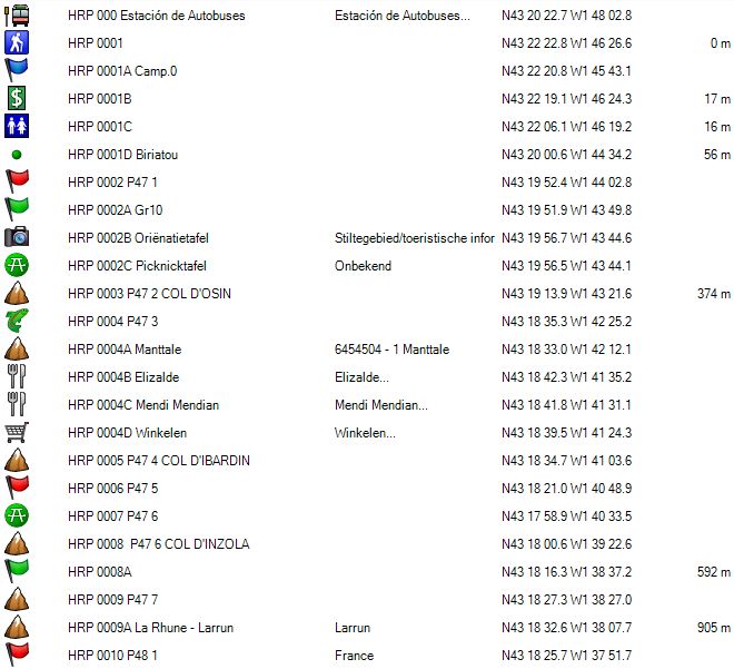
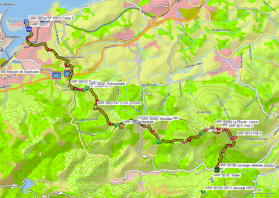
Here, you turn left. You go underneath the road and arrive at a roundabout. Here, you go between the buildings. You walk into a dead-end street that ends at a tunnel for pedestrians underneath the railway tracks. At the other end you follow the road in the same direction and you arrive at the D358. You follow it to the left and leave the D358 after 100m to the right. At a T-junction, you turn right and then after 400m you turn to the left. Follow this road towards the busy D810. You cross this road and continue down along a narrow path in between the trees. At the next intersection, you turn right. You round a hilltop and then continue in the same direction. You make a turn to the right and walk in the direction of the A63. Just before the ramp, turn left and then you will find a small road to the right that leads to a tunnel under the A63. You go through the tunnel and continue your way south towards HRP 0001D Biriatou. From here it goes in a southeasterly direction to the first waypoint in the Ton Joosten guide (HRP 0002 P47 1).
Then you go eastwards to HRP 0002A Gr10. Here is a vague road in the flank of the mountain, which also leads to the waypoint HRP 0003 P47 2 COL D’Osin. However, the GR10 goes over the ridge. Then you pass by HRP 0002B, place of an orientation table and HRP 0002C, a Picnic. You walk for a while in the flank of the mountain, and the GR signs lead you up the ridge. You follow the ridge until you reach the HRP 0003 P47 2 Col d’Osin.
You descend to a saddle and then climb up the other side steeply. Just before a stream bed (HRP 0004 P47 3), you don’t cross this, but you go to the left around the ridge of the Manttale (HRP 0004A). You continue your hike at leveled altitude, to continue with a descend towards the asphalt and the tourist circus of the COL D’IBARDIN (HRP 0005 P47 4).
You’ll pass several restaurants and souvenir shops and even two stations. At the roundabout just before the Total petrol station you arrive at the main road. The GR10 goes to the left here and stays in France. The HRP stays in Spain. You follow the main road down to the right, until you can turn to your left into a side road (asphalt). Follow this road to the restaurant Okalarre (actually a banquet hall). You leave the asphalt and turn left just in front of the fence (HRP 0006 P47 5). You follow this path that leads towards the dirt road, which you could also have followed, as it leaves to the right just before the restaurant Okalarre.
On the dirt road turn left and you pass a picnic with a source. Immediate past here, turn left and climb up to a crossroads (picnic) with a signpost to La Rhune (Larrun) to the left. Then you reach the COL D’INZOLA (HRP 0008 P47 6).
Here you take the dirt road which is prohibited for vehicles under penalty of a fine of € 300. If you arrive here in the full midday sun, your courage to climb is briefly taken away when you realize where the endpoint of your climb is located, being almost at the top of the summit of La Rhune (Larrun) with its broadcasting mast and buildings 😦.
As on all dirt roads, the climb is unpleasant because of the condition of the road and the lack of shade. At GPS waypoint HRP 0008A you can follow the road to the left, or follow a path straight ahead. This path ends at the ruins of a farmhouse, where you need to go back up a bit to reach the road again. You persecute this road into the flank below the summit towards a ridge of the mountain, where you take a turn counterclockwise until the ruins of a building (HRP 0010 P48 1). Here you can go to the circus at the top of La Rhune (Larrun) (only those who need to supplement their water supply).
The HRP turns to the right here and follow a faint path on a spur of La Rhune (Larrun) until a vague junction (HRP 0011 P48 3), where you turn right and descend in a zigzag and then in a straight line towards HRP 0013 P48 5. The point HRP 0013 P48 4 you don’t really pass. First, you follow faint yellowish-white markings, which change into yellow markings.
You make a right turn. The horizontal part towards a boundary stone is very vague and overgrown. On the border, there is a very steep path down (faint blue markings) to a large hut for hunters (HRP 0014 P48 6) in a sort of pass on the edge of the forest.
Here you follow the road into the flank of the mountain (slightly up) at the edge of the forest (orange markings). In the descent you will pass several small hunting cabins. The road bends to the right and at the crossroads you turn left and continue to drop further in the same direction until just before the road you will find:
Hostal-Restaurante Lizuniaga Jatetxea (HRP 001 5B)
Language: Spanish
Tel: +34/948631031
Open: All year, possibly closed in early summer. (Gives a closed impression, but is open). Sign in at the kitchen.
Half-board in a room: No recent prices online! (room with two beds, private bathroom and TV)
1 / 2L Red wine and bread: included
Dinner (19:30):
1st: large mixed salad with cheese and ham
2 °: Pasta with 3 slices of pork roast
3 °: dessert: cheese platter.
Breakfast: from 7:30 am (Saturday)
4 toasted buns, jam, butter, fruit plate (plenty), coffee or tea
Day 02: Col Lizuniaga -Arzikun |
25.5km |
+1046 |
-971 |
Including rest: 7:30’, without: 7 :00’ (although: rest in this case was relatively 😦)


You leave the hostel and cross the road, being the actual COL DE Lizuniaga (HRP 0015 P48 7). You go straight ahead. The concrete road soon turns into a dirt road. You pass a fountain (HRP 0015C) and the second road comes from the right, where the GR11 joins the HRP (HRP 0015D). You continue to follow the GR11 to the COL BAGACHETA (HRP 0023 P53 5).
After crossing the asphalt a second time at the COL D’Ursua (HRP 0019 P53 1), you climb slowly through the forest, followed by more open ground covered with ferns. When you start to descend, and the road takes a turn to the left, you will find a GR-marked path on the right, which descends slowly toward the COL D’ESQUISAROY (HRP 0021 P53 3). After the pass follows a climb over a rough path that flattens and continues to rise slowly. At HRP 0022 P53 4 is the path is joined by a fairly horizontal road, coming from the left. You go to a pass, where you’ll find small bunkers along the road. The road descends slowly and splits itself. The main road makes a turn in the clockwise sense, and to the right there is cut off of this curve. There is a wooden pole with a name in the Basque language, of which you can only decipher the altitude of 795m. This is the COL BAGACHETA ( HRP 0023 P53 5 ) . Here you leave the GR11.
Make the arc in the clockwise sense and at the highest point, leaving the road for a hard to define path to the left. You descend towards the grade of a hill. You will find a path to the right of this ridge. At the second bump, change your sides.
In an oak grove, try to find a path between the ferns in the direction of a dilapidated farm with the remains of a red tile roof. Here begins a road that goes down slowly and changes sides in a breach in the ridge, to further go down along a goat stable and the cemetery of Azplikueta ( HRP 0024B ) . Only I came across goat, which clearly didn’t appreciate my presence.
Confrontation with a male goat
Initially the animal was grazing peacefully in a bush along the roadside. But when it noticed my presence, he moved towards the middle of the road and blocked the passage. Usually you expect that kind of animals to spontaneously take a run, but this was clearly a different character. The beast had 50cm long twisted horns with a span of approximately 80cm. It showed nearly all forms of threat in the form of standing on its hind legs, encircling me, to lowering the head with its horns forward. If you know that the animal, standing on its hind legs, was greater than this lonely walker, you may understand that this did not came across as very reassuring. Fortunately, there were two walking sticks between me and the beast.
A first attempt to get rid of him was at the height of the goat stable, but the wall was too low, because the beast jumped smoothly on the wall. A second attempt was at the height of the cemetery. I went through the gate of the cemetery wall. This wall is significantly higher. Only just before this wall, there is a staircase leading to a chapel. After a jump over a low fence, the goat climbed up the stairs and jumped from the top of the stairs on the wall. Not willing to make the same mistake twice, I waited until the goat jumped from the wall and then quickly went through the cemetery gate and locked it. After picking up one of the lower parts of my telescopic walking sticks, which I lost during the battle, I made myself scarce and above all out of sight.
In the village of Azplikueta ( HRP 0024B ) you only come across annoying dogs, but they are usually called to order by the owners. Whoever was the owner of the goat, I didn’t figure out. My Spanish is not strong enough.
From Azplikueta ( HRP 0024B ), you descend to the N121-B, after which you climb toward your ultimate aim Arzikun. You reach it via a backstreet from Ordoki ( HRP 0024G ) , which starts at the grain silos and returns at a roundabout to the main street. On foot, you can continue on a historic bridge, where you can find a tap ( HRP 0024E). The bridge continues into a historic road, which you leave after a curve for a path that climbs up toward your final goal Arizkun.
In the main street you turn right and opposite the indoor handball alley, you’ll find FONDA ETXEBERRIA (HRP 0025 P54 1). This is the actual center of the village, being at the same time bar, restaurant, village shop and hotel for HRP and other lost travelers.
You sleep in the annex house located within walking distance of FONDA ETXEBERRIA (Annex with bedrooms) (HRP 0025A).
FONDA ETXEBERRIA (HRP 0025 P54 1) (Closed according to Google Maps :
Language: Spanish
Tel: +34/9484530 1 3
Alternatief:
Casa Rural Zilbetinea
C. Larrain, 14, 31713 Arizcun, Navarra, Spanje
+34948453489
65€ (2024) room for individual use, with breakfast.
This probably concerns the annex that was used by the former FONDA ETXEBERRIA for overnight stays.
Meals:
Poligono Ordoki S/N Valle de Baztan
31713 Arizcun Espagne
+34 948 45 31 65
Day 03 -04 : Arzikun – Roncesvalles |
30.4km |
+1845 |
-1194 |
Les Aldudes: without rest: 3h15 ‘
Total: without rest: 8:15’, including rest: 9:30’


You leave your sleeping quarters through a street which runs behind the FONDA ETXEBERRIA ( HRP 0025 P54 1 ). You turn right into a street, where you’ll find yellow-white markings. Where the road bends to the left, go straight ahead over a path through the forest. This road is very muddy after rain and you can avoid this by continuing to follow the asphalt road. At the end of the forest the HRP joins the road again. Follow the road to the right. Where this road ends, you do not turn diagonally right towards a farm, but you go straight ahead over a country road. At HRP 0026 P57 1 turn left. At HRP 0027 P57 2 the HRP makes a right turn. Keep climbing towards HRP 0028 P57 3.
Take the fastest rising road until it ends at two successive closures ( HRP 0029 P57 4 ). The first is locked with a chain. Climb over the first gate and open the second, or climb over the fence to the left to get into the meadow. Follow the fence to your right along a vague trail. At the height of some trees, you can turn left in the direction of the ruins of a barn. From here you must walk through the long grass, diagonally through the meadow towards the ridge and the forest at the highest point. In the corner of the meadow, you will find under the trees a step over the fence. You arrive here on a forest road. Ton Joosten sends you up once again through the woods to the ridge of Burga (HRP 0 031 P57 6), but you can also just follow the forest road to the left. This road turns to the right and then continues towards COL BASABAR (HRP 0032 P57 7) (much easier :-).
Over here, again the same scenario. The guide will send you over the ridge (white-green waymarks) which is good for a brutal climb. Those who end this stage at Les Aldudes, can safely follow the guide and the ridge here. But those who continues until Roncesvalles, better turn to the right and follow the white-yellow markings, which remain in the side of the slope. You’ll pass a farm, where they also sell cheese and follow the signs to the COL DE BERDALITZ (HRP 0034 P58 1) .
Here you cross the pass. You do not continue the track along the ridge, but a path that goes diagonally to the right in the flank and then descends slowly into the woods. At the end of the forest, you can already see Les Aldudes lying down in the valley. You turn to the left. The forest roads changes into an asphalt road. You continue on this road until the end, where you go left towards the center of Les Aldudes . You cross a bridge and turn right.
Across from the gas station (HRP 0036 P59 1) and shop you can find a rough concrete staircase, which ends at a gate. You open the gate and continue your way through a steep and somewhat technical path zigzag up the hill. A bit further, you continue to climb in a straight line towards a saddle called COL LEPEDER (HRP 0037 P59 2) with a hut for hunters. You climb here towards the right, along the ridge. At the highest point, you will find a way across the saddle towards the left. The road climbs again at first light to a hunting cabin and then descends to a pass. You end up on a crossroad, where you have follow a path straight ahead, which is largely overgrown with ferns. This path slowly climbs to the left towards the asphalt road (power line along the road). On the asphalt road, you turn left. At a junction turn right. You climb to a saddle with to your right under a tree, a shed (HRP 0039 P59 4). Here you leave the road and follow the ridge over a vaguer way. In a kind of cirque (HRP 0040 P59 5) you leave the road that climbs up along the ridge for a road that turns off to the right and continues into the flank of the mountain. Somewhat further the trail turns sharply to the left. Here you can see the further course of the climb in the direction of the COL DE MIZPIRA (HRP 0041 P62 1) .
From the COL DE MIZPIRA, you follow essentially the ridge, sometimes by a path, sometimes without. At HRP 0041A you can either continue along the Col de Errola (HRP 0042 P62 2), or take a road that links the col by a road that drops 50m and continues to the saddle past the Col de Errola (HRP 0042A).
You descend further to the COL DE MEHARROZTEGUY (HRP 0043 P62 3) .
From the COL DE MEHARROZTEGUY (HRP 0043 P62 3), you can either continue along the path over the ridge, or along the longer road below the ridge. At HRP 0043A the path joins the road again and the HRP follows the road along the COL DE TEILARY (HRP 0044 P63 1) to a fork (HRP 0045 P63 2). Here you take the slightly uphill road to the right up to the Col D’Hauzay (HRP 0045A).
At the pass, go to the left and continue along the road up to the Col de Burdincurutcheta ( HRP 0046 P63 3 ) (Cheese available) . From here, the GPS will send you the over the REDOUT DE LINDUX (HRP 0047 P63 4) . It is easier to simply follow the road to a saddle behind the REDOUT DE LINDUX. Over here you can find GR signs. Continue to follow the asphalt to the Col de Ibañeta (HRP 0047A). From the pass you can descend via the Camino to Roncesvalles (way marks not to be missed 🙂).
Just before the inn, turn right and then turn left through a passage, so to reach a courtyard and beyond the garden at the front of the complex. Here you can turn right towards Casa Sabina or straight on towards La Posada.
CASA SABINA (HRP 0049D)

Language: Spanish , French
Tel: +34/948 760 012
Open: All year
Night in a room: (room with 2 beds , private bathroom )
Menu: (menu peregrino )
Dinner ( 7:00pm or 8:00pm )
1st: soup
2 °: trout with potato or beef stew with fries
3 °: dessert: yogurt .
¼ bottle r ode or white wine, ¼ bottle of carbonated water and a piece of bread: included.
(size of portions could be a bit larger)
Breakfast: from 6:15am
2 croissants, 2 toasted sandwiches, jam, butter, coffee or tea (didn’t have to pay for the breakfast ) .
LA POSADA (HRP 0049F)
Half-board: (all in for 1person, room not booked in advance )
(looks expensive on the internet, but discounts are given possibly under pressure from the Casa Sabina.
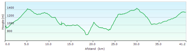
Day 05-06: Roncesvalles – Col Bagargui |
41.2km |
+2031 |
-1659 |
Total : without rest: ca.11:30′ including rest 12:30’ (from Chalet Pedro by road, not along GR)

You can start from Roncesvalles along the Camino in the opposite direction towards the COL Lepoeder / PORT DE CIZE (HRP 0050 P65 1) .
You can also use the variant of the Camino along the way (same way you used yesterday) back to the Col de Ibañeta (HRP 0047A) .
From here you can continue to follow the HRP and GR again. In the Cicerone guide it is incorrectly referred to as the GR11, but according to the markings on the ground, this concerns the GR 8 and GR 12. The GR 12 is a specific Basque GR, with all maps and signposts in the Basque language. Not tourism friendly. Identity is clearly more important than commerce and tourist friendliness.
From the Col de Ibañeta, you follow the asphalt road to the COL Lepoeder / PORT DE CIZE (HRP 0050 P65 1) . The GR uses shortcuts here, but they are usually very brutal and steep, so it’s better to follow the road. On the Col you’ll find the Camino, which you can follow in the opposite direction until shortly before the Fontaine de Roland (HRP 0052 P65 3), where you turn right. En route, you pass the Refuge Izandorre (HRP 0051A – Emergency Accommodations , 2 beds without mattresses) (listed in the Cicerone guide as the Cabanes de Bentarte).
Just before the Fontaine de Roland (HRP 0052 P65 3) you turn right and follow the GR 8 (not GR11) signs up to the pass near waypoint HRP 0054 P68 3 . The GR path here uses a shortcut. As a result, the waypoint in question is no longer situated along the trail. This is a frequently returning problem with the waypoints mentioned in the Cicerone guide. You get the impression that they were marked on a map and not out in the terrain, along the path.
On the asphalt turn left and then make an S. The second bend you can cut short through the open terrain. Then you go in a straight line towards the COL D’ORGAMBIDE (HRP 0056 P68 3).
 To the left of the pass you’ll see a cromlech (stone circle). Here you turn right and follow the road until its almost lowest point. Here you’ll find a vague dirt road leading towards a farm. Along the way you will find a fenced plot, which you should keep to your right. Then you’ll find a way down toward the PONT DE CHUBIGNA (HRP0058 P68 6). At the bottom of the slope you can find a better path, that descends towards the bridge in question. You cross the stream via the bridge and on the opposite side, you go downstream until just before the riverbed of a tributary. Find an initially narrow and a by grass heavily overgrown path with faint red and white markings, that climbs slowly into the flank and then climbs vertically in the narrow riverbed towards the COL D’ERROZATE (HRP 0060 P69 2) . Just below the pass, there is a fence to stop the cattle. From this fence there is no path towards the pass.
From the pass you cut short the bend in the asphalt road, using a dirt road under a hut. Then you descend along the asphalt road until it makes a turn to the right. Here you descend into the riverbed and find Border Stone BS 223 ( HRP 0061 P69 3 ). From here you follow the left bank of the main stream and descend towards a farm, where you return to the main road via the access road. Follow this to Border Stone BS 224 (HRP 0062 P69 4) L’Egurguy (the official end of the fifth stage).
Those who carry a tent, can camp here. For those who don’t carry a tent, there is no other option, but to continue walking until the Col Bagargui.
The beginning of this second part of this stage is difficult.
You turn right and crossing a bridge. The description is very vague here and leave much to the imagination. Follow the road towards a gully between two hills. Find a vague cattle track up along the the bend in the asphalt road gully here. Continue to follow this until you come across a good cross track and follow this until you reach the ridge of the mountain (HRP 0063 P70 1). Then climb further along this ridge and then in the side of the mountain towards the GR trail (HRP 0065A) . During the climb you cross many cattle tracks, which all descend. So you have to cross all of these until you reach the track, where you’ll also find GR signs. You follow this path to the left until the COL CURUTCHE (HRP 0066 P70 4), where you turn left. The road goes partly through the woods and in this section there are very marshy spots. The road ends at the COL D’ORAATE (HRP 0067 P70 5) , which is accessible to vehicles.
You don’t follow the asphalt road, but turn to the left. The road slowly climbs into the flank of the Okhabe (HRP 0068A) and ends on an open piece of flatland, covered with grass. Already from far ahead of the wooden signpost at waypoint HRP 0068 6 P70 , you can cut short towards the GR 10 marked dirt track, which ‘returns’ in the direction of Okhabe (HRP 0068A) and then make a left turn. First, you continue in an easterly direction, to leave this wider road for an initially smaller and more obscure one at waypoint HRP 0069 P71 in the direction of the woods. From the edge of the woods, the road becomes wider and is heavily eroded. You descend towards the asphalt of the D18. Over here you go to the left.
On the left side of the road, you will pass Chalet Pedro.
Chalet Pedro:
Cottages are only rented on a weekly basis here.
The restaurant prices are “pricey”.
At the moment that we passed here, neither patio nor the restaurant were open.
You’ll find a tap here, between patio awning and the front façade of the main building.
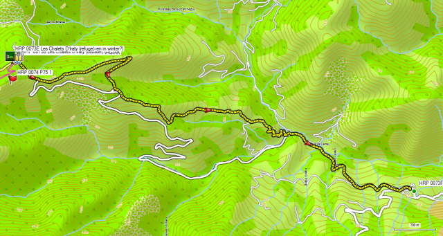
You continue your way along the asphalt of the D18 to a crossroads. Here you turn right towards Col de Iraty/Bagargui. Just about 100m past the junction, you will find a signpost on the right (HRP 0071 P71 3) with indications of the GR10. Those who combined stages 5 & 6 in one day, can be better continue to walk along the road. The climb is more gradual and you do not have to descend. The same applies to the second part from GPS HRP 0072 P71 4 D19 on.
Les Chalets d’Iraty (refuge – HRP 0073A)
Language: French
The information section of Les Chalets d’Iraty (HRP 0073A ) is only open until 19.00. Those who arrive later must contact the manager of the property (HRP 0073B Les Chalets d’Iraty (manager)). There you’ll find the shop, restaurant (closed) and the cottage (shelter).
Night: € 18 (2024) a person in a ‘room’ for two.
The room is very narrow with a bunk bed, and a chair.
Common bathroom and kitchen.
Shower with coin (including , 5 ‘ ): Don’ close the tap while taking your shower or you’ll lose the rest of your shower time. Bad for the environment….
Shop: some cans and other long preserving types of food. Bread in the morning after 8.00 am .
Supper: warm up the food you bought at the shop 😦.
Day 07 : Col Bagargui – Larreau |
9.0km |
+173 |
-843 |
Total: without rest: 2:30 ‘ including rest 3:00’
 Larreau is not situated on the HRP, but in the valley. We were picked up there by the wife of my Australian travel companion for a transfer to Lescun. Lescun itself is not accessible by bus, which goes only as far as the Pont de Lescun in the valley. Then rest there is no alternative but to go on foot (5km of uphill road) or by hitchhiking from the bridge to Lescun. Curiously enough, the school bus runs into Lescun, but this service is not provided to the public in general.
For those who don’t have the luxury of a private taxi at their disposal, will have to come up with another solution.
Walking over the GR10 is possible, but it requires at least three days.
Given my schedule was fixed from Gavarnie on, there was no margin left to cope with such unexpected events. So plan some slack or rest in your schedule (which was normally foreseen, but which I gave up, to accommodate my (second) travel companion from Gavarnie on) .
Stages 07, 08 and 09 have only one unmanned overnight point, without supplies or any other comfort. Moreover, you have to cross the Zazpigagn ridge and the Pic d’Orhy on day 7 . The combination of stages 8 & 9 is also long: 11:15’ according to the Cicerone guide.
These are not ideal circumstances in very bad weather.
The predicted storm was forecasted in the afternoon, but arrived actually in the evening. In Lescun we all in all noticed very little of the storm, but the photos in the local newspaper the next morning told a completely different story. Bulbs of hail as large as golf balls, have locally caused much damage (mostly in the lower valley).
A variant of the GR10 descends to Larreau, but it’s not marked. The descent was carried out mostly ‘freestyle’, which is not always ideal.
Part one is essentially a path, but makes a large size hairpin turn, to return to the road. Part two starts well, but the path fades and finally we had to descended freestyle back to the road. Part three restarts well again, but the end of the path is used by locals as a kind of waste dump for branches. Part four is partially heavily overgrown. The designations are not removed, but a letter from the city council was hung up, indicating an alternative along the road. Along the way you’ll notice fairly recent road signs which prohibit motorized traffic (C3), but the path is so overgrown that it is de facto impossible to pass. There is an alternative along the asphalt from the hamlet of Inchauspe -Bordalépoa to Larreau and it is advisable to use this if the situation does not improve.
And so there was not much else to do than almost two days of forced rest in Lescun 😦 .
Gite du Pic d’Anie (HRP 0104E):

Language: French
Tel: +33/559347154
Open: All year
Night in a room: 58 – 63€ (2024)
Dorm: 17 € per person per night.
Breakfast: € 8 (expensive: buying bread and marmalade in the store is cheaper)
Half board and dorm: 25 + 17€
Bar des Berger (HRP 0104F) :
Menu:
Dinner (7:30pm):
1st: soup
2 °: duck or turkey
3 °: dessert .
Wine: € 3
Les Tables d’Haute (HRP 0104B) :
Plat du jour: (no place inside, so only in good weather)
Between village shop and Marie (town hall) up and then left.
Store (HRP 0104K)
Pretty wide range of products. Also French topographic maps and the old HRP guide by George Veron. Both Camping and Optimus gas.
La Poste Lescun (HRP 0104I)
Tuesday, Thursday, Friday and Saturday: 09-12
Wednesday: 14-16
Note: the post master is the cook at Bar des Berger. She is willing to fetch a package from the post office if you don’t arrive between opening hours.
Day 10 : Lescun – Ref d’Arlet |
18.3km |
+1557 |
-384 |
Total: without rest: 6:00’, including rest 6:15’


From the Hotel du Pic d’Anie you descend in the direction of the Bar du Berger and then turn right towards the bridge over the river. Those who want to follow the GR on the other side of the river are confronted with very brutal climb. You can also use the road, making the climb a little slower. At the campsite you follow the GR along the asphalt road further uphill. At GPS waypoint HRP 0105 P93 1 LESCUN, you cross another road and go straight on towards the Col de Pau. Further on you cut off a few turns of the road. After the second cut off, you leave the GR and follow the road. Further down, the road makes a hairpin turn. The road ends at a ‘parking lot’ and turns into a dirt road. 300m further you cross the river via a bridge (HRP 0106 P95 1). The road continues straight ahead, but if you continue along this road, you have to cross a river without a bridge. On the other side you follow a path to the place where the road crosses the river.
From here on, you get into the territory of the cows and the state of the road shows it. Here’s proof of what you get when there are too many cows…. It’s looking for a more or less solid ground, with your shoes in the mud. You cross the PONT D’ITCHAXE (HRP 0107 P95 2), but this won’t improve things much. The state of the road remains bad until the Cabane d’Itchaxe (HRP 0107A), where you pass underneath. The road then fades and becomes a path. From the ruins of the Cabane du Penot-de-Haut (HRP 0107B), the path is more clearly defined and you can follow it smoothly to the COL DE PAU (HRP 0109 P95 4).
From COL DE PAU the path goes way up and down much along the border ridge. You pass the path (signposted) towards Lhers (GPS waypoint repositioned, because this specified position in the Cicerone guide is wrong) (HRP 0110 P96 1). From the waypoint HRP 110A Cabane de Lapassa you find a descending path to Borce. The turnoff is not indicated here. The path is difficult to follow, until the REFUGE D’ARLET (HRP 0111 P96 2) is visible . The path, which is indicated on the OSM map, corresponds to the logged path on the ground.
REFUGE D’ARLET (HRP 0111 P96 2):
The cabin has three levels:
-
Ground floor: winter room and toilets (sink, no shower)
-
First floor: entrance, dining and kitchen and storeroom backpacks and shoes
-
Second floor: living room (accessible via a steep staircase)
In the cabin there is great caution with regard to possible contamination by undesirable insects like flees. Upon entering the cabin you have to shake out of your sleeping bag and you need to repeat it when leaving. The backpack should stay down. The effectiveness of these measures is unknown to me.
Only 5 guests in the hut itself and a sixth in his tent.
Language: French
0033/559360099
0033/648993822
Half-board: 44€ (2023)
Dinner (7:30pm):
1st: soup, bread
2 °: cutlet, risotto, vegetables
3 °: dessert: pancake and fruit cocktail
Breakfast (7:00am to 8:30am):
Muesli and cereal, very little bread, 2 slices of gingerbread, coffee, tea or hot chocolate .
Thanks to the muesli: OK.
Day 11 : Ref d’Arlet – Candanchu |
18.8km |
+805 |
-1248 |
Total: without rest: 6:45’ including rest: 7:15′

 You cross the small dam underneath the cabin and follow the trail along the banks of the Lac d’Arlet. At the end of the lake the trail bends towards the left and then goes up along hill side toward the pass (HRP 0112 P97 1). You round the Pic d’Arlet and descends largely into southeastern direction towards the PASS CABANE DES CAILLAOUS ( HRP 0113 P97 2 ), near the eponymous hut. You don’t turn left towards Cabane de Gourgue Sec , but continue in an easterly direction towards the COL DE LAPACHOUAOU (HRP 0113A), where you turn south towards the Cabane Grosse (HRP 0113B (locked)).
You arrive at the locked cabin, where the road begins. When the road starts to rise, there are two possibilities:
1) Keep on following the road towards the PLA D ‘ ESPELUNGUERE (HRP 0114 P100). Here you turn left.
2 ) You follow the path that is indicated to the right. This path goes over in a road. This road zigzags and descends slowly, so you can easily cut off the hairpin bends. You arrive at a signpost towards Cabane D ‘ ESPELUNGUERE (where you can get cheese in the season) . Here you turn left to the PLA DESPELUNGUERE (HRP 0114 P100 1). Here you turn right.
On the PLA DESPELUNGUERE (HRP 0114 P100 1) you leave the road. You walk towards the river where you turn right along the river towards the bridge (HRP 0114A Passerelle D’Espélunguère). You cross the river and continue 100m straight ahead. Then you turn to the right . 250m further on, you arrive at a signpost, which only indicates the path to the left and this is the only visible path. Nevertheless, you need to bear right here, and go along a very faint path through the grass. At the forest edge the path becomes clearer.
Also in the forest path remains fairly vague and you need to pay attention. There are cairns (stacked stones). The actual course of the path is quite different with the designated path on the OSM-card. Once up, you arrive at a stone building of the EDF (Electricité de France).
At this point a road starts which degrades into a path. Over here you will find the ladder (about 3m high, in metal and mounted to the rock wall), which gives its name to the pass.
A bit higher you will reach the actual Pas de L’échelle (HRP 0116 P100 3) and the nearby lake Ibon the Estanes (HRP 0116A . Descend towards the lake and round this pointer sense. Across the lake the path becomes unclear, because there are multiple (cattle) tracks, which sometimes fade and are very clear at the height of streams to cross. You go in the direction of a clearly visible pass, where you’ll find a large cairn. From here on the path descends lightly towards waypoint HRP 0117 P100 3. From here on, you can find signs of the GR11. Here you leave the path that descends towards the valley and climb slightly to the right to continue to go up and down, along the border.
You see the COLLADO DE CAUSIAT (HRP 0118 P100 4) from afar, but it takes quite a long time before you actually get there. To remain more or less at the same height, you need to make a big detour, and especially Le Gave D’Aspe (HRP 0117A) is an obstacle on your way to Candanchu.
 You descend through the woods down to the bed of Le Gave d’Aspe . You cross a first arm and then you need to descend along the riverbed, to cross a second arm. The flow makes the necessary caution imperative. Usually you come across few problems along the GR11, but this is clearly an exception to the rule.
On the other side of Le Gave D’Aspe , you see two paths cross the scree. The top one is eroded, so you must use the lower one. The next part of the gorge is very overgrown. At the end of the gorge, you need to climb out of it, in the direction of the COLLADO DE CAUSIAT (HRP 0118 P100 4).
In the descent, the path is vague. You descend towards the ski installations and then you take the road to the left. In the descend, you round a the military complex and continue towards the asphalt road. On the main road, you descend to the right until you find a side road where you leave the main road via a hairpin bend.
Here you will find next to each other:
REFUGIO EL AGUILA (HRP 0119 P101 1) (Only open in winter?)
Language: Spanish
0034/974373291
At El Aguila there was a group of children present, which resulted in the necessary fuss made there. That is why we opted for the neighboring Refugio Valle del Aragon.
REFUGIO VALLE DEL ARAGON (HRP 0119A)
Language: Spanish
albergue_valledelaragon@hotmail.com
0034/974373222
Half-board: No recent tariffs online!
Room with seven beds for the two of us, 4 showers and toilets in the corridor
Dinner (7:30pm):
1st: pasta, bread
2 °: meatballs
3 °: dessert: fruit
Wine and water included
Breakfast (07:00am):
Bread and lots of cookies, coffee or tea
HOTEL EDELWEISS: (Only open in winter?)
Half-board: ???
Day 12 : Candanchu – Ref Pombie |
15.0km |
+1370 |
-858 |
Total: without rest: 6:30’ including rest 6:45′

 From Albergue you return to the main road. Here turn left and go up in the direction of the Col de Somport. About everything you encounter along the road is closed (shops, bars, restaurants). Only Aysa on the pass itself was open from 08:00am on.
On the pass, you turn to the right and immediately to the left towards Astun. With Astun in sight, you can go diagonally left towards Hotel Europa (HRP 0119J) , to pass along the back side of the hotels. Over here, at the Estación de Esquí de Astún (HRP 0120) right next to the mountain stream leaves a very vague and steep path . This path ends on a gravel road. You go to the left until the road ends and becomes a path again. This path climbs on the right side of the river gully. You round the lake in a counterclockwise sense, and then climb up to the COL DES MOINES (HRP 0121 P103 1).
 On the other side you descend without any problem until you reach the turn off towards the LAC CASTERAU (HRP 0122). Here you’ll find GR signs, which you can follow downhill. You’ll pass the lake and continue to descend further in zigzag to a gravel road (HRP 0123 P103 2).
You cross a gravel road to find a little further the continuation of the path along which you go down towards the bridge (HRP 0123A) across the river. You cross the river and follow it upstream towards a hut, called CABANE DE CAP DE POUNT (HRP 0124 P103 3) with a corral for gathering animals.
As was concluded from the Cicerone guide, finding the path here is not evident. First and foremost you need to understand where to go, and that’s somewhat surprising.
You do not follow the main valley. You do not follow the valley in line with the CABANE DE CAP DE POUNT. The easiest is that you follow the path into the main valley beneath the CABANE DE CAP DE POUNT, then to discern in the flank to your right a faint zigzag pattern in the direction of a small pass between two bumps on the ridge. Walk in the direction of the zigzag pattern in the flank, to find a path there, that brings you smoothly towards the pass (HRP 0125 P106 1). Behind this pas you’ll find a valley, along which you climb further towards the LAC DE PEYREGET (HRP 0126 P106 2).
You round the lake and once you are above it, you arrive into a zone of boulders and snow (if you are early in the season). You have to be very careful in the ascent in the direction of the COL DE PEYREGET (HRP 0127 P106 3) . The descent is not easy either. Because of the snow the path was difficult to find (in July 2014) in the downhill direction towards the REFUGE DE POMBIE. Because of the snow, we made use of a clear spur in the snow, followed by a secondary path in the side of the mountain towards the REFUGE DE POMBIE (HRP 0128 P106 4).
You can avoid the difficulties in the vicinity of the COL DE PEYREGET by going around the pass via a lower pass, instead of across it. You will do this by using the more visible path to the right towards a saddle, and from there descending towards the REFUGE DE POMBIE. The path is longer, but definitely simpler and faster in the beginning of the season.
THE REFUGE POMBIE (CAF) (HRP 0128 ):
Open: 1st June until 30th September 
0033 / 559 053 178 (very noisy cabin in nice weather and at weekends, popular with rock climbers, reservation recommended !!!!)
Language: French
Half-board : 36,50€ (2024 – members)
45 bunks inside the building and 16 in a tent !!! No showers!! Toilets downstairs. Limited electricity supply (solar panels)
Dinner (7.00pm)
1st: soup, bread
2 °: chili con carne with rice
3 °: cheese and dessert
Breakfast (06:30 am)
Cereal, 3 slices of bread, pre-packaged toast, gingerbread, jam, butter, coffee , cocoa or tea
Day 13 : Ref Pombie – D934 |
5.0km |
+67 |
-673 |
Total: without rest: 1:30’
At the hut, it was already clear: everyone went down and returned to the valley, so there was free space in the cabin. Forecasts for the next few days were very bad, with daytime temperatures of 0°C at 2800m. If you know that the easiest pass ( COL DE LA FACHE ) ( HRP 0145 P119 7 ) is located at 2664m, you know it is not going to be a walk in the park.
A young French couple who already had orientation problems on day 12, demonstrated again their when trying to leave the D934, but still persevered despite not having crampons nor ice axe. A group of Belgians who were in possession of this equipment also continued. None of these parties have reached the Refuge Wallon within 2 days.
Given the bad weather forecast, my Australian companion again contacted his wife, who came to pick us up on the D934 in the valley.
The descent itself is hassle free.
We descended by car to Cauterets from where we wanted to begin the climb from the Pont d’Espagne to the Refuge Wallon the next day.
Haphazardly we sought shelter in Hotel Odalys.
Odalys -balneo Aladin :
Only open in winter?


Avenue du Général Leclerc 11 , BP 62
65110 Cauterets
Night: € 65 per room.
Dinner (L’Aragon, next to city hall) :
Cheapest pizza in Cauterets and tastes well too.
1/2L Red wine: € 5.50
Alternatieven:
https://www.booking.com/city/fr/cauterets.nl.html
Day 14 : Pont d’Espagne – Ref Wallon |
7.6km |
+488 |
-56 |
Total: without rest: 2:00 ‘

 The weather forecast for the next days was good and so we drove with courage to the Pont d’Espagne in the rain 😉. Once at the car park (HRP 0149 ) our heads were still in the clouds, but it actually only drizzled .
Given the weather, the parking lot was very empty. The waterfall at the Pont d’Espagne, which makes a very nice picture in nice weather, was a bit disappointing because of this weather.
You can either go between the Pont d’Espagne and the Hostellerie Pont d’Espagne over the footbridge to the left or you can continue along the asphalt for long the Hostellerie Pont d’Espagne, then along the funicular 😦 to continue along the ski chalet /refuge Chalet Du Clot ( HRP 0149C) (Half-board: € 50 – 2024). You continue along the river towards the bridge (HRP 0149B) that you cross to join with the path from the Pont d’Espagne. (HRP 0149D) From here you go further upstream proceeding along the now gravel road, and later on mountain road at the beginning of the forest (1675m) . Usually you take the path to the right, that is not marked, but which is very clear. Higher up the path joins the mountain road again. From here on you descend a bit towards another bridge (HRP 0149A) over the Gave du Marcadau, after which follows a flat piece of alpine meadow with cows. At the end of the pasture, do you start climbing again to a fourth bridge (HRP 0149E ) on the Gave du Marcadau, you must cross again tomorrow. Today, however, you remain on the same bank and continue your way to the Refuge du Wallon/Marcadau.
The cabin was, given the weather, very empty. Most hikers we encountered went down.
REFUGE WALLON / Marcadau (HRP 0148):
Open: 1st June until 30th September
0033 / 562 926 428 (very noisy cabin in nice weather and at weekends, popular with walkers, reservation recommended!!!!)
Language: French
H / P : 57,00€ (2024)
120 bunk beds underneath the roof or in small rooms (2 to 4 persons), no showers, toilets downstairs. Limited electricity (solar panels), could use a freshening up.
Dinner (7:00pm )
1st: soup (large portion), bread
2 °: beef stew with rice
3 °: cheese and dessert (cake)
Breakfast (06:30am – 08:00am )
Corn Flakes, Cocoa Crispies, muesli, toast, gingerbread, jam, butter, coffee, cocoa or tea (self-service, so nothing in short supply 🙂).
Day 15: Ref Wallon-Ref Bayssellance |
12.9km |
+1506 |
-727 |
Total: including rest: 7:20′, without rest: 6:50′

From the Refuge Wallon, you descend towards the Pont d’Espagne until you reach the first bridge ( HRP 0149E) on the Gave du Marcadau. You cross the river to find a good path. A little further you cross a second bridge (HRP 0149F), this time on the Gave D’Arratille . Nearly 2km further you cross a third bridge (HRP 0149H), again on the Gave D’Arratille . 250m further you reach the Lac D’Arratille , which you round partially in counterclockwise sense.
From the lake you can find cairns to a feeder stream towards the lake coming out of a narrow gully. Straight ahead you will see nothing more, and then you go to the right where you find old paint marks, coming out of the direction of the lake, but were not observed there.
Follow the signs up. The path takes a turn through the ramp and returns in the direction of the river gully. The markings are very vague and therefore you need to seek the ‘path’. At the height of snow fields, you can only look for a track upwards. The characters are too old and too faint to be visible from afar. Given the bad weather of the recent days and the relatively early hour, we were the first on the road and there were no clear visible tracks in the snow.
 Higher up, you find the in July 2014 almost fully frozen up lake (Lac du Col D’Arratille ). In the flank of this you have pretty steep snowfields, ending in the lake, that you should cross on your way towards the Col D’Arratille (HRP 0149I). After 2:45 ‘ of searching, you reach the pass.
On the Spanish side you’ll find a clear path in the flank. The painted way marks here are oddly painted over with white paint. Ironically this make the signs clearer. In this flank, you have to pass a number of snowfields, which are steep. You see the Col des Mulets (HRP 0149K) on the other side of the cirque, and you could be startled by its steepness. After 1 hour you reach the Col des Mulets .
In the descent of the Col des Mulets there are plenty of steep snowfields. Without an ice axe it’s better to cross them as shortly as possible and continue the descend through debris fields that are free of snow.
Once in the flat part of the cirque (OULETTES DE GAUBE) near the hut with the same name, you can’t walk on sight straight towards the cabin, as there is a river, that needs to be crossed. You can do this better via the bridge, which is on the left side of the hut, if you want to keep your feet dry, but here again thz waymarks on the terrain are fairly unclear.
REFUGE DES OULETTES DE GAUBE (HRP 0150):
Open: 1st June until 30th September 
Beds: 85
Tel: 0033/562926297
0033/562454136
Booking advisable.
H/P: 45,25€ (leden – 2024 – hoogseizoen)
The cabin is accessible from the Pont d’Espagne and therefore a magnet for day trippers. At the time of our presence here, there was school classes of teenagers here who were clearly more focused on sight in their makeup mirror, then on the landscape surrounding them.
No shoes allowed inside the cabin !!! ??? Incomprehensible. One toilet for day trippers. With a school adolescents, this is somewhat problematic. Friendly for the real mountain hikers? They didn’t sell me anything anyway, as a result.
In the descent from the Col des Mulets, you can see the path toward the Hourquette d’OSSOUE (HRP 0152 P125 2). From the hut, climb in the flank, parallel to the river. The path is/was very wet. At first, it zigzags vertically upward in the direction of the waypoint HRP 0151 P125 1. You will find a signpost marked: ‘Col: 1 hour, Hut 1 hour 30’. Over here there is a split and the trail goes to the right, more or less horizontally, slowly climbing in the flank. The last part of the climb takes place almost entirely on snow. The Hourquette d’OSSOUE can only be seen at the last moment.
From the pass the REFUGE DE BAYSSELLANCE (HRP 0153 P125 3) is clearly visible. The official trail to the hut is situated in the flank left of the snow field and then descends in zigzags, only to end up still in a snowfield. Usually you will also find a trail through the cirque which goes directly towards the hut. The official path is safer.
THE REFUGE BAYSSELLANCE (HRP 0153):
Open: 1st June until 30th September 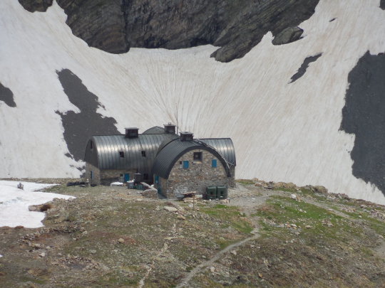
Tel: 0033/562924025
0033/974776652
Beds: 58 bunk beds under the roof.
Booking advisable (starting point for an ascension of the Vignemale) .
Language: French
Half-board: HP: 45,05€ (2024, voor leden van een bergsportvereniging)
Backpacks and shoes remain in the entrance. There are baskets in order to bring up your belongings to the sleeping quarters. The walls in the sleeping quarters are wet with condensation.
The cabin has two French toilets and sinks with cold water.
Dinner (8.00pm)
1st: soup, bread
2 °: beef stew with rice
3 °: cheese and dessert: mouilleux de chocolat
Breakfast (06.30am)
3 small white and 3 brown slices of bread, 2 slices of gingerbread, jam, butter, coffee, cocoa or tea (quite copious for a high-altitude hut :-))) . In addition, the climbers of the Vignemale didn’t finish their breakfast basket, which they then passed on to others with more time 🙂.
Despite the weather forecasts, the summit of Vignemale remained largely in the clouds. Those who made the mistake of staying at the REFUGE DES OULETTES DE GAUBE to enjoy the postcard view , did have to pay for this privilege the next day with a climb in the icy cold.
You can certainly camp at the REFUGE DE BAYSSELLANCE. The tenting spots are cleared flat places, surrounded by a circle of stones 🙂.
Day 16: Ref Bayssellance – Gavarnie |
14.6km |
+328 |
-1477 |
Total: without rest: 5.15 ‘
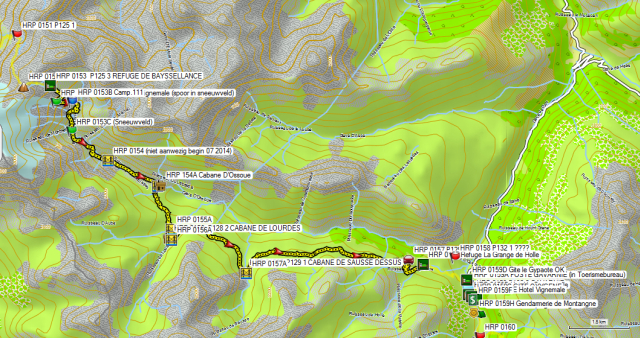
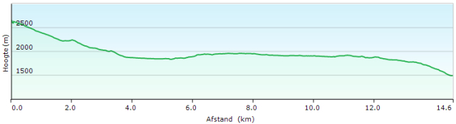 Apparently some succeed here not to find the way to Gavarnie….
Even though it’s not that difficult…
You leave the hut and walks to the Cairns in front of the door of the hut. Here you will find a path that descends in zigzag towards the gully, where the snow field coming from the Hourquette d’OSSOUE is situated. You cross a spur of the snowfield /river. Lower you go to the right in the flank. At the waypoint HRP 0153A , the path towards the valley makes a hairpin bend to the left. Those who follows the trail straight up in the snowfield, end up on Vignemale. Apparently, some people need a lot of time to realize that Gavarnie is located in the valley and not uphill…
You descend further towards Gave d’Ossou that you follow downstream. You have to make some in between climbs in function of natural obstacles.
At 0153C GPS you will have to decide according to the condition of the snow field, where you will cross it. The original path is quite high in the flank, making it quite steep in the snowfields. At the beginning of the season, you’ll find a track that crosses the snowfield at level.
The bridge over the Gave d’Ossou (GPS 0154) was at the beginning of July 2014 not passable, because of works in progress. An apology for this was posted at the Maison du Parc in Gavarnie 😦 . And so the river had to be crossed over the still solid upper snowfield on the Gave d’Ossou.
Following the bridge, you stroll through a flat stony valley / riverbed until you reach the Lac d’Ossoue. At the end of the lake you’ll find a car park and a shelter (GPS 0154A). Those who are tired can also follow the gravel road, later asphalt road towards Gavarnie.
Those who still have energy, cross the Gave d’Ossou over the bridge behind the dam and climbs into the flank towards the CABANE DE LOURDES (HRP 0156 P128 2). From the bridge on, you finally find recent GR way marks. 200m before the hut you find a relatively new bridge (HRP 0155A ). Just below the cabin you’ll find a second bridge (HRP 0156 A ). You return towards the main valley.
At the height of the CABANE DE SAUSSE DESSUS (HRP 0156B P129 1) the path goes away from the main valley. At the hut you cross a tributary again. After the river, you take the middle path in level. A little further you will find GR way marks. The path goes up and down until you arrive at an electrified fence with a pasture gate. From here you descend. At the height of an antenna, the path makes a striking turn to the left.
In the view of the road in the valley, the path becomes unclear again because of cattle tracks. Walk here parallel with the electric fence down until you find a clear path with way marks. Then follows a zigzag trail towards the road. You cross the road. At the opposite side you’ll find an initially narrow white-red marked path that becomes wider and clearer. This path reaches the road within sight of the Grange de Holle. Again, the way marks are unclear. On sight you walk to the car park at the front of the Grange.
Refuge La Grange de Holle (CAF) (HRP 0157):
Open: 1st June until 30th September
Tel: 0033/562924877
Beds: 62 in rooms of varying sizes
Booking recommended.
Language: French
Half-board: 40,55€ + 12,95€ (2024 – members)
The shoes remain in the entrance. The cabin has two normal toilets and showers with unlimited hot water (free after the departure of the non-residential customers).
Dinner (7.00pm)
1st: soup, bread
2 °: duck (quite salty) with rice
3 °: cheese and dessert: cake
Breakfast (7:00am – 08.30am)
Bread (toaster available), gingerbread, cereal, etc., jam, butter, juice!, coffee , cocoa or tea.
In 15′ you descend through the parking lot to the road. You descend via the road until you pass a hairpin bend and find what looks like a private drive way to the right. You descend via a gravel road until just before a house, then you go to the left and descends along a path right up to the tourist office of Gavarnie .
At Gavarnie you’ll find alternative lodging options at:
Gite d’étape Le Gypaete (HRP 0159D) :
Open: all year
Tel: 0033/562924823
Beds: 45
H/P: 46€ (2024)
Gite Oxygene (HRP 0159C) :
Open: all year
Tel: 0033/562924061
Beds: 57 (10 rooms with 4 to 9 beds)
Overnight stay with breakfast: 50€ (2024)
Breakfast: bread, (cold) pancakes, jam, butter, juice !!, coffee or tea
Supper: in the restaurant in front of the inn:
Confit de Canard, salad and French fries: € 10
Post (HRP 0159A) :
The post office Gavarnie can be found in the tourist office, but has limited opening hours: 09 – 12am.
The parcel which I sent from Belgium ‘Post Restante’, arrived, but was again heavily taped and sealed with Post de Toulouse tape. Of the 8 daily rations which I sent from Belgium 6 arrived. In the box, a 1/5 filled glass bottle of perfume was put in place of the two missing daily rations. I photographed the things on the spot and filed a complaint with the local post master who connected me by telephone to a manager in Toulouse. Result: I had to file a complaint in Belgium, despite the fact that the facts clearly occurred in Toulouse.
In Belgium, I filed a complaint with B-Post. We are still waiting for an answer.
In the past, I already sent equipment from Austria and Italy to Belgium. I never had any complaints. Only at the French Post there are issues .
ATM (HRP 0159F) !!!!:
Lies somewhat hidden in a passageway between two houses, about 80m past the Gite Oxygene on the right side (about at the height of the Hotel Vignemale).
Hotel Vignemale (HRP 0159E):
tel : +33 (0) 562 924 000
+33(0)689229665
Kamer: vanaf 160€!!!
Camping La Bergerie (HRP 0159G )
Camping on a very steep terrain with terraces.
Camping at La Grange de Holle is free, if you eat there. That choice is quickly made.
Supplies:
In a tourist hole like Gavarnie, you can find tourist stuff at extortionate prices. The choice is limited, the prices high. There are two shops selling food.
Mailing my supplies as ‘Post Restante’ towards Gavarnie was not a bad choice, but the staff of the French Post has to learn to bring their own food to work .
Something to drink …
Usurious rates typical of a tourist hole:
Day 17 A : Gavarnie –Ref Espuguettes |
5.8km |
+703 |
-137 |
Total: without rest: 1;45 ‘

 Start off day for the third man, rest day for the other two 😉.
For those who didn’t start at Gavarnie, the entire stage 17: Gavarnie – Heas can easily be completed in one day, given the lack of technical difficulties, even in early summer.
From the tourist office, you just follow the herd towards Gavarnie. On the bridge near the campsite you cross the river and follow the right bank.
You can either already take up the climbing path to the left, 150m past the campsite and then to go to the right at the next fork to arrive on the official path, after crossing the stream.
You can also walk up to the signpost (HRP 0160) and start climbing there.
Initially, you can still enjoy some shade, but at the height of the sign HRP 0161 P139 2 PLATEAU DE PAILLA , you go to the left and you pass the tree line.
From here on, you walk over the mountain meadow, first towards the Cabane de Pailla. You do not walk up to the hut itself, but works your way up with the cows, to get back on the path from the cow herding shed.
The day tourist follow the steep path straight to the hut. Know, that there is a path that climbs slower and in a hairpin bend towards the hut. This way you arrive at the hut from the backside. Those who drag up a fresh load of food, better choose the original path. After 1h45′ you are up.
Around the hut, there are half-wild horses and donkeys who like to do deposit their manure near the hut. So, watch out where you’re going, is the message.
Under normal circumstances, you can continue easily to Héas.
To make proper use of the spare time, you can do some laundry (weather permitting obviously).
From here on, all overnight points were reserved for two people, but we succeeded to stay overnight with three persons each night (with some improvisation 😉).
Refuge des Espuguettes (PN) (HRP 0162 ):
Open: 15th June until 15th September 
Tel: 0033/562924063
Beds: 60
Booking advisable. (Hut was booked solid with a school children, what you get with a readily accessible cabins 😦).
Language: French
Half-board: 46,15€ (2024)
The shoes remain in the entrance. The cabin has two normal toilets, two sinks in a cubicle, so have some privacy, but there are no showers.
Dinner (07.00pm)
1st: soup, bread
2 °: pasta, sausages with peas
3 °: dessert
Breakfast (07:00am):
Lots of bread , no cereal, gingerbread , jam, butter , coffee, cocoa or tea.
|
Day 17B : Ref Espuguettes – Héas |
14.1km |
+574 |
-1057 |
Total: without rest: 4:45 ‘
Day 17 Total: without rest 6:00′ 19.9km +1277 -1194


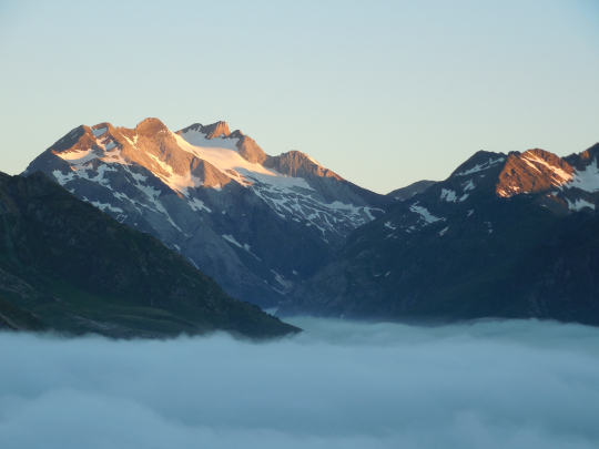 From the hut you can both see the pass, the HOURQUETTE D’ALANS (HRP 0164 P142 1), and the last part of the path towards it. The beginning of the path is vague, given this proceeds in a pasture which is grazed by cattle. You leave from the hut in a northeasterly direction. Ahead, you will find a clear path / cattle track. The path zigzags in an easterly direction, in function of the circumstances on the terrain, until you reach a split near waypoint HRP 0163 P139 3 (faulty coordinates in the Cicerone guide 😦) with the path to the Piméné (2801m). Here you turn to the right and follow the foot of the ridge leading towards the HOURQUETTE D’ALANS (2430m), a climb and pass without any technical difficulty.
Just below at the other side of the pass (HRP 0165 P142 2), do not take the path right towards Spanish border, but the path that descends to the left in an easterly direction. Lower in the descent, the path turns south, towards the center of the cirque. Along the way down, you passer a second split (HRP 0166 P142 3 (again faulty coordinates in the guide) of a path towards the Spanish border.
Here you go definitely to the left, in the downstream direction towards the Lac Des Gloriettes (lake).
The description in the Cicerone guide sends you along the western shore of the lake and the dam.
You can also cross the river towards “Parking” via a concrete bridge (HRP 0166A), 250m before the lake. 150m further the path is rather vague. You have to look out for upright vertical stones that serve as cairns. Further down the path becomes clearer. You pass a fork (HRP 0166C Alternative path to LE MAILTET, for whom found no shelter at LA MUNIA) with a path to the right / straight ahead , which brings you through the flank towards the Cirque de la Troumouse (HRP 0170B).
If you have booked in La Munia, follow the path to the left down to the parking lot. Along the way you pass a gate in a fence.
Turn left at the parking ( HRP 0166D Parking Lac Des Gloriettes ) towards the asphalt. You follow the asphalt in zigzag downhill to the bridge across the river (HRP 0168 P142 5) in the valley .
On the main road (D922) turn right and follow this until just past the church of Héas (HRP 0169A Chapelle Notre-Dame).
In Héas itself, it was difficult to stay in July 2014. Just the AUBERGE DE LA MUNIA ( HRP 0169 P142 6 ) was open. The adjacent CAMPING LE CAIRN (HRP 0169B ) had been closed for a year. The AUBERGE LE REFUGE ( HRP 0170), located at the tollbooth on the road to the Cirque de la Troumouse (HRP 0170B) was closed.
Besides the AUBERGE DE LA MUNIA there is/was only 4km further and 300m higher situated hostel Le Mailtet (HRP 0170A) open in July 2014. So if you haven’t reserved places at the Auberge de la Munia, you can better take the route in the side of the mountain to reach Le Mailtet, as described above.
AUBERGE DE LA MUNIA (HRP 0169 P142 6):
Open: all year
Tel: 0033/562924839
Beds: 10 in 4 rooms
Booking advisable. (Was fully booked).
Language: French
Half-board: 55,00€ (2024)
Red wine: included
Dinner (7:30’pm)
1st: Sheppard’s pie with duck, bread
2 °: roast with potatoes and lettuce
3 °: dessert: ice cream
Breakfast (07:30’am):
Croissants, fruit juice, toast, bread (ask for extra), little jam, lots of butter , coffee or tea.
Day 18A: Héas -Ref Barroude |
12.5km |
+1393 |
-556 |
Total: including rest: 6:30’, without rest: 5:45’ (depending on snow conditions)
Day 18: together: including rest 11:30’, without rest: 10:30′ 28.3km +1616 -1997
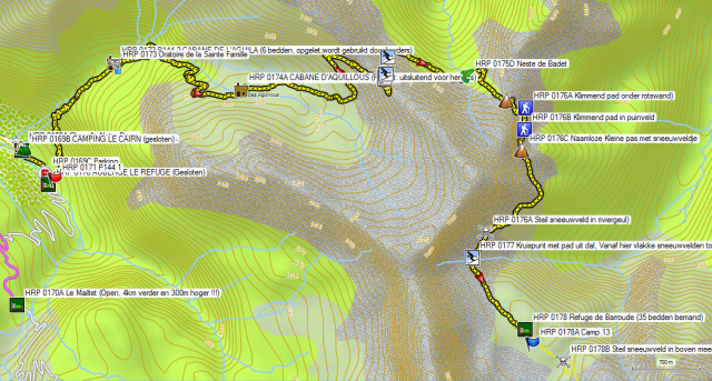
 You leave AUBERGE DE LA MUNIA to the left on the asphalt. At a kind of split, you’ll find to your left a parking lot (HRP 0169C). Over here the asphalt turns into a gravel road. After only 100m there is a fork, where you leave the main road to the Cirque de la Troumouse (HRP 0170B) to the left for a path to the HOURQUETTE DE HEAS (HRP 0175 P145 2). The path returns in the flank of the mountain until you get just above the Auberge de la Munia. Here it goes up along the river. You pass two bridges over the river, which you ignore. You stay on the left bank. Somewhat further between the second bridge and the shepherd’s hut (CABANE DE L’AGUILA (HRP 0172 P144 2 – 6 beds, attention is used by shepherds)) the path is eroded at the bottom of the slope, and you have to improvise somewhat. Across the cabin you will find a Marian shrine along the path (HRP 0173 Oratoire de la Sainte Famille).
You climb up the slope above the cabin. You pass underneath a rock and round it clockwise next to the river. Higher up the path zigzags between two feeder rivers of the previously mentioned river. Here, it’s not always easy to identify the main path. Higher up, the path resolutely goes to the left in the flank of the mountain, and in the direction of the CABANE D’AQUILLOUS (HRP 0174A – Private: only shepherds).
At the height of the hut you have to watch out that you do not continue to follow the path along the river, but that you cross the river in the direction of the hut. In the immediate vicinity of the cabin, the path is again somewhat unclear. You walk here at best somewhat parallel to the river, but later on the path becomes way more clearly. Higher (at about 2400m) the path makes a striking turn to the left. 500m further, the path makes again a striking turn, now to the right (at about 2450m) . You’ll find yourself in an area of loose rock. The path is sometimes a bit unclear in the rock mass. In between the path makes a number of shorter zigzag movements just below the ridge (at about 2575m) before finally going to the left towards the narrow pass HOURQUETTE DE HEAS (HRP 0175 P145 2 – 2608m).
 In early summer, you look down the other side of the pass on a huge steep cirque of snow. If you are here at a time of low clouds or fog, the situation is even more difficult. One ill-equipped French solo hiker did not like the descent, and retraced his steps.
Just below the pass, turn right on “flat” plate stones, to go a little further to the left to HRP 0175A, where the path disappears underneath the snow (at the beginning of the season). In this case it makes sense to deviate to the right in the direction of the beginning of a steep debris field (HRP 0175B). You descend “Freestyle” through the debris field until you reach the waypoint (HRP 0175C), at the end of the steep debris field and back on the path again. Left of this point, there should be a split of paths, according to the OSM-map, but this junction was totally invisible, because of the snow coverage.
Along the path, you descend further to the Neste de Badet ( HRP 0175D – 2336m) , a good spot to take in some calories, to brace yourself for what the rest of this stage has in store for you.
The climb to the HOURQUETTE DE CHERMENTAS (HRP 0176 P145 3 – 2439m) is quite simple. The first part of the descent is short is simple too. At waypoint HRP 0176A you’ll find a junction and where you need to follow a climbing path right underneath a striking cliff. The path is littered with manure from chamois, but the beast themselves you won’t see. You continue in the direction of from afar visible path that climbs through the debris field (HRP 0176B). This path ends on a small Pass without a name with a snow field (HRP 0176C). The path which descends from this pas initially seems pretty harmless, but passes over two snow fields in river gullies, which are very steep. Since Gavarnie, I was in possession of crampons, but not an ice axe and thus the two crossings needed to be done with two walking poles in combination with the crampons. You better not have any problems with vertigo, to execute these passages without any problems. At the end of the second snowfield ( HRP 0176 A ), after observing our passage, 2 Austrians suddenly returned on their steps. This stretch can be avoided through the valley at the cost of 5 additional kilometers and 600 additional altimeters both in ascent and descent.
The path goes smoothly in the direction of the intersection with the normal access path from the valley (HRP 0177 P145 4). From here on you’ll find (in the early summer) a flat snowfields towards the hut ( HRP 0178) Refuge de Barroude (35 beds – burned down in 2015) ). The route towards it is marked with metal rods in the snow.
Refuge de Barroude ( PN – HRP 0178 – 2373m ):
Closed: burned down in 2015. Check http://refuge-barroude.fr or www.ffcam.fr (Club Alpine Français) for the latest information.
Tel: 0033/562396110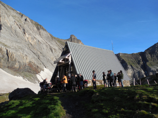
Beds: 35
Booking advisable. (Was booked solid by a group of Basques on a weekend trip 😦).
Language: French
It’s a very small cabin with the living space on the ground floor and normal sleeping quarters underneath the roof. The shoes go on a rack in the living / dining room . The backpacks have to find a place in the niches against the wall. Hanging on the right wall are 5 extra beds, which can be lowered after 10.00pm, after the tables were moved. Disadvantage: You can’t lie on your bed during the day, but the chances of having to cope with snoring, is smaller and in addition they are also € 5.00 cheaper than a normal overnight fee. The cabin has one normal toilet and one sink in a metal shed behind the hut. (Women who have to take a leak at night, know what awaits them. As a man, you can just do it outside the front door … ;-)) No showers. (Really basic thus.)
Note on day18: including rest: 11:30’, without rest: 10h30’, 28.3km +1616 -1997
Looking at the figures of day18 (Héas – Parzan), one should realize, that the entire stage can only be completed under the most ideal conditions, both in terms of snow coverage as well as other weather phenomena. Splitting the stage at the Refuge de Barroude seems advisable, especially early in the season when a heavy snow load is still present. As long as the Refuge de Barroude is not reconstructed or alternative lodging is put in place, this situation presents an additional difficulty.
Day 18B: Ref Barroude – Parzan |
15.8km |
+223 |
-1441 |
Total: including rest: 5:00 ‘, without rest: 4:45’
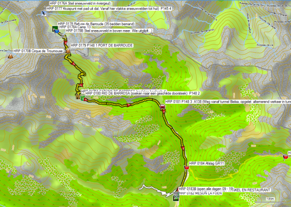
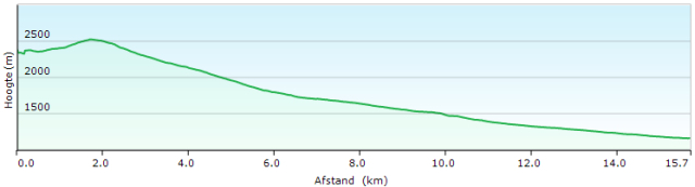 Between Refuge de Barroude and PORT DE BARROUDE ( HRP 0179 P148 1 ), you have to cross three snowfields in early summer. For those who slept at the Refuge de Barroude, this means that you will have to do this in the morning and especially after a clear night, the snow will still be frozen:
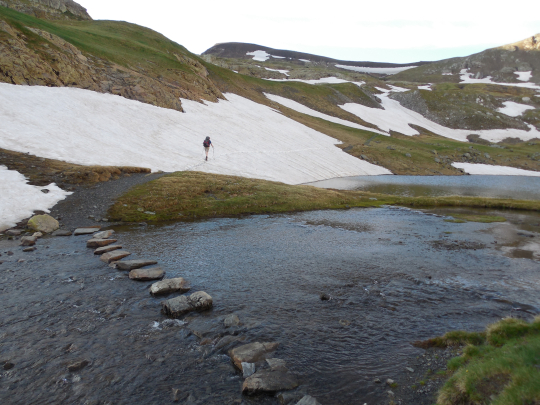
-
The first snow field is pretty steep.
-
The second snow field (HRP 0178B) is less steep, but if you slip here, you’ll end up in the lake. You can simply bypass this snow field along the upper side. (Our Basque friends have effectively done this after too much alcohol the previous evening. 😉 )
-
The third snow field is relatively flat and presents few problems.
The PORT DE BARROUDE is a relatively flat and open col. You descend down the other side via a white and yellow marked path to the CABANE DE BARROSA (HRP 0179A – closed shepherd’s hut). Near the cabin the path is vague. 200m past the hut, you need to cross the river RIO DE BARROSA (HRP 0180 – P148 2). It’s searching for a suitable crossing place, for those who want to keep their shoes dry (in early summer).
Once past the river, you first have to cross a field of boulders in the river bed. On the other side you have a great chance of spotting Isards. They really don’t seem shy and look for minerals near the rocks.
Slowly the path becomes better and evolves into a forest road. Those who carry lighter footwear, can change here. Until Parzan you won’t meet any technical difficulties. What’s more … there is a stretch of 5km asphalt to be dealt with, in order to reach the Meson La Fuen at Parzan and having to do this with type C shoes is not really recommended. After 3.3km you will pass the gravel road, where you’ll leave the asphalt tomorrow. You continue to descend to Parzan, where you’ll find a relatively large food store (daily 09 – 21h), besides a restaurant, a gas station, an ATM and completely at the end of the hamlet the Meson La Fuen. The negative feelings Ton Joosten has about this hotel are beyond me …
MESON LA FUEN (HRP 0182) :
Open: all year
Tel: 0034/974501047
0034/974501170
Beds: 32
Language, Spanish
Half-board: vanaf 60€ (2024)
Red wine: included
www.alberguesyrefugiosdearagon.com
Dinner (8:00’pm (Spain)):
Choice of five starters, five main courses and five desserts (portions rather small for hikers)
Breakfast (08:00’ (Spain 😦)
Croissants, fruit juice, toast, bread, raw ham !! ! jam, lots of butter, coffee or tea (good, but late 😉)
|
Day 19: Parzan – Ref Viados |
20.5km |
+1547 |
-946 |
Total: including rest: 6:00′, without rest: 5:30′
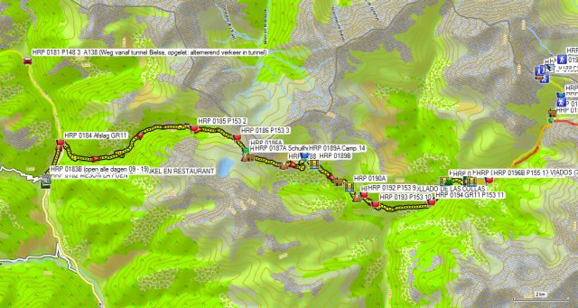
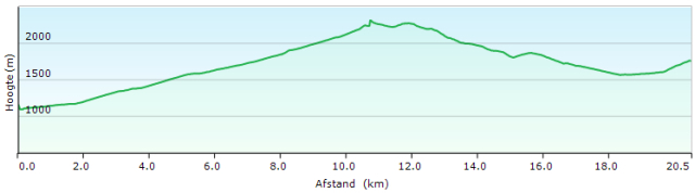 Technically speaking, this day has no difficulties in store. You leave Parzan along the same road as yesterday. After 1.7km, you leave this road for a gravel road to the right (HRP 0184). You’ll find GR11 way marks and a signpost: “Lago de Urdiceto 11km” . You cross a bridge and start to climb in the flank of the main valley. Further on, you turn left in a tributary valley.
Follow this road until you reach the service road of a hydroelectric power plant (HRP 0185 P153 2). Here you leave the gravel road and follow the service road together with the way marks of the GR11. Further up, you leave the service road for a mule track which passes along the lake and returns to the gravel road. You follow the gravel road until the next hairpin bend (HRP 0186 P153 3) , where the GR11 leaves the gravel road again for a mule track, which remains lower in the flank than the gravel road. The GR11 climbs back to the level of the gravel road just below the pass. At the waypoint HRP 0186A, you’ll find a split. Over here you go to the right. The path disappears partially under a snow field and then you need to improvise to find a path across a bolder field. Eventually you’ll arrive back at the gravel road and reach the PASO DE CABALLOS (HRP 0187 P153 4). The road continues in the direction of the Lago de Ibon de Urdiceto, but you leave it to follow eastwards an initially declining path. Just beyond the pass you’ll find a shelter / emergency accommodation (HRP 0187A).
The trail first descends into the side of the cirque, to continue climbing back to a spur of the mountain ridge. From the highest point, you descend back into the underlying cirque. This part is locally very marshy and the soil contains traces of iron. Sometimes you need to improvise.
You cross the river via a bridge (HRP 0189B). Across the river, you need to cross a rather marshy area again, where the orientation is somewhat difficult. Don’ descend too much, but rather remain at the same level, until you find indications of the path again. You descend to a barn (HRP 0190 P153 7), where a gravel road commences. In the first hairpin bend, can you leave the road to follow a steep and rough path, which cuts short the bend in the road, to arrive back on it. The road then descends to the bridge (HRP 0190A), to climb back uphill on the other side to arrive at the COLLADO DE LAS COLLAS (HRP 0191 P153 8). You descend again along the road until you reach a signpost (HRP 0192 P153 9). From here on, you follow the GR11 way marks, that cut short every bend in the road. At the next signpost (HRP 0193 P153 10), you leave the road once again, to return to it quickly. Follow the road again, which descends towards a bigger road in the valley (HRP 0194 GR11 P153 11). Here, you climb back up again towards a bridge (HRP 0194A). Just before the bridge, you’ll find a camp ground for youth groups.
Just past the bridge you will find a small CAMPING FORCALLO (HRP 0195 P154 1), where you can have a drink. Hereafter follows a brutal climb along a path that cuts short the bends in the gravel road. Eventually you reach the REFUGIO VIADOS (HRP 0196 P154 2).
REFUGIO VIADOS (HRP 0196 P154 2)
Open: 1st June until 30th September 
Tel: 0034/974341613
Beds: 70
Language: Spanish and French
Half-board: 35,30€ (2024)
www.alberguesyrefugiosdearagon.com
Dinner (8:00pm (Spain)):
1st: soup, bread
2 °: salad, meat, potatoes, tomatoes
3 °: dessert: peach
Breakfast (06:00am – 08:30am (Spain 😉)
Toast, cake, cookies, small brick of juice, jam, butter, coffee or tea (meager and slow 😦)
|
Day 20: Ref Viados – Ref Soula |
13.7 km |
+1172 |
– 1218 |
Total: : Including rest: 9:00’ without rest: 7:30′


Route choice:
The HRP is a technically difficult route, which can only be done in the best possible circumstances, and certainly not in early summer with high snow load.
Given time is a precious commodity, that is not unlimitedly available to someone who belongs to the working class, the completion of the HRP was spread out over two years. And then Bagnères-de-Luchon comes into the picture as breakpoint, given its good rail link to Paris and Belgium. The disadvantage is that you have, or are forced, to follow the original route of the HRP. Somehow the Spanish-French border needs to be crossed, if not through the tunnel of Bielsa, it will be across the PORT D’AYGUES TORTES. To complete this stage, you will need crampons, walking poles or an ice axe and a especially a large dose of experience and common sense.
Those who do not absolutely have to be in France, better follow the technically easier route of the GR11 in early summer. Ton Joosten might be condescending about choosing the GR11, but he lives in the Pyrenees and can complete the difficult stages in nice weather…. Make sure you do not end up in a rescue helicopter.
Stage:
You’ll leave the hut and descends to the gravel road. Then you cross the river ( HRP 0196A) and climbs along a road underneath several barns to a fork (HRP 0196B P155 1). You do not cross the river, but continue to climb along a narrow path to the left of the river.
After 1km, there appears to be a discrepancy between the track log of the GR11 and the path shown on the OSM map. OSM map has it right. After 2km both fall back together again. The path slaloms through a gap under the Cabane d’Anescruzes, a new shepherd’s hut , which visible from afar on a hill above the path (HRP 0196D) .
After crossing first a tributary river (west) and then the main river (north), the GR11 and the HRP split. The GR11 continues eastwards to the PUERTO DE GISTAIN (HRP 0197 P190 1 – 2572m). HRP continues further north on the left bank towards the PORT D’AYGUES TORTES ( 2683m).
There is indeed a path to the PORT D’AYGUES TORTES, but it’s vague and requires a lot of attention to follow, given that the cairns are rather small and the path itself is much ingrained in the landscape. The trail is marked on the OSM map and is quite correct.
Initially, you follow the river, but at the height of a small waterfall you ward off to the right, to round the cliff area to the right of the waterfall. After the waterfall, you return to the vicinity of the river, but you remain above the bed. Further on, in early summer, you need to deal with a large snow field in the river gulley, which you can circumvent at best via the right flank. At the waypoint HRP 0196E you return to the path, after the snowfield in the river gully.
Higher up, then you need to cross a snowfield again, which also coveres the riverbed. So be alert to the course of the river under the snow and try to avoid a passage of the river itself, using a snowfield or snow bridge, unless you are really sure of the strength of it. At the waypoint HRP 0196G your return towards a path that is visible in the debris field after crossing a broad snowfield beside river gully. The river itself can be seen from afar, flowing over the rocks to your left. From here on, you continue without any further problems towards the PORT D’AYGUES TORTES (HRP 0199).
You need to take a deep breath, after looking down from the pass into the valley. What seems on the OSM map neatly drawn zigzag path, is in reality in early summer buried below a thick and above all steep snowfield. Those with a little bit of common sense, know that it’s not advisable to descend this snow field. So you’d better start looking for an alternative route.
Those who have done their homework and gave a look at the old map in the hallway at the Refugio de Viados, know that there used to be a path that descends from the pass an outflanking movement.

And so you follow at best the ridge over a length of 200 meter to the left. Then you descend over a number of natural “steps” in a bare landscape, until you arrive at waypoint HRP 0199A, where you return to the path after an outflanking movement.
Not much further, you are again forced to leave the “path” at a steep snow field. When you arrive at waypoint HRP 0199B, you can return to a path after a steep snow and debris field. At waypoint HRP 0199C, the path disappears again under the snow. This time it is a very long snow field, beginning steeply at 45° , but gradually flattening to nearly horizontal. After the snowfield follows a block field, before finally ending up in open terrain.
At waypoint HRP 0199D (wooden pole and frame) you finally can find something which looks like a “normal” path.
At the Refuge de Prat-Cazeneuve (HRP 0200 – 8B unmanned), you better take a break, because the descent to the Refuge de la Soula, may be safely labeled as troublesome . Of 2 men with daypacks, who thought they could rapidly descend towards the Refuge de la Soula, one disappeared with a splint in the rescue helicopter.
It is not advisable to switch to lighter footwear here. You can better until the Refuge itself, before making a change.
REFUGE DE LA SOULA (HRP 2 012):
Open: 1st June until 30th September 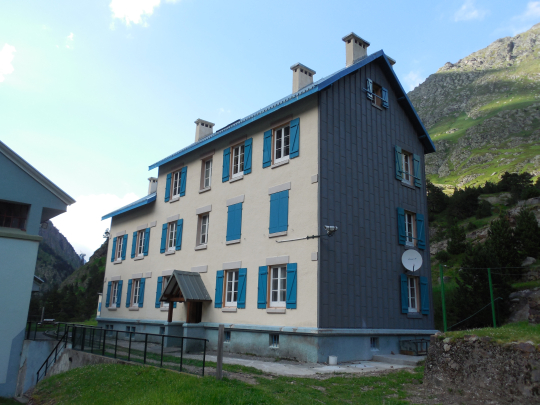
Tel: 0033/562402341
Beds: 60
HP: 47,00€ (2024)
Language: French
refugedelasoula@gmail.com (winter)
Dinner (7:00‘pm )
1st: soup, bread
2 °: salad, sausage, rice, tomato
3 °: dessert: apple sauce
Breakfast (07:00 – 08:30am):
Bread, gingerbread , jam, butter, coffee or (green) tea (ask for additional bread!!!! )
|
Day 21V Day: Ref Soula –Gr d’Astau |
19.0 km |
+1048 |
-1580 |
Total: including rest: 8:00 ‘, without rest: 6:45’
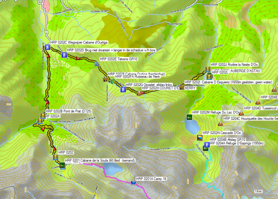
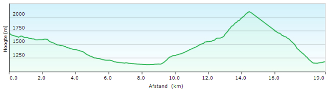
Route choice:
HRP follows the trajectory: REF SOULA – REF PORTILLON (9,3km + 1365m -448m). This stage is evaluated by Ton Joosten as a level E stage (Exceptionally difficult). Considering the fact that I observed that during the descent of the PORT D’AYGUES TORTES (level 1 = very difficult) a traveling companion had trouble descending in steep snowfields, I found it irresponsible to drive up the level of difficulty and I made the decision to continue to Bagnères-de-Luchon along the GR10, despite the fact that the weather conditions were good.
In the hut a family with three children aged between 10 and 16 years, left in the direction of the Refuge de Portillon. The children had crampons, in combination with only one walking pole. Afterwards we learned that out of a rope group, one person made a fall and one person went towards cabin to look for assistance. Apparently there is no GSM coverage in the valley. The facts were observed by a mountain climber, which was located higher up on the slope and who could make contact with the cabin using a transmitter, which then notified the emergency services.
The advantage of having already richly filled resume, is that it is easier to let common sense prevail over ego. (And so I decided to continue along the GR10, but with a heavy heart).
Stage:
This route can be found on the Garmin City Navigator, but not on the OSM map !!!
You’ll leave the hut along the narrow service railway track of hydroelectric plant and continue to descend along the right bank of the river. At the waypoint HRP 0202, you cross the river over a bridge and to continue descending it further down, along an artfully landscaped path in the flank above the river. Once in the forest, you can choose between a very direct descent or descent in zigzag. When you reach waypoint HRP 0202A, you cross a bridge again to arrive on asphalt. You continue to descend along the asphalt, while passing to the left of the terrain of hydropower plant . You cross the Pont de Prat ( HRP 0202B) and end up at the public car park lot, at the bottom of the hydropower plant, at the beginning of the D725. On the terrain of the hydropower plant also ends the cable car from la Soula . This cable car is reserved exclusively for employees of the hydroelectric plant.
The car park fills up early in good weather. Follow the D725 downstream over a distance of 3.5km, until it makes a distinct S-curve. Over here you will find a signpost to the Cabane d’Ourtiga (HRP 0202C). From her on, you must climb along a brutally steep gravel road, until it flattens out in a more open part. At waypoint HRP 0202D, you’ll find a bridge. If you don’t cross it, you walk along a path which remains longer in the shadow of the forest. If you cross the bridge, you walk along a gravel road through open terrain. Both variants come together again at a small dam with a bridge at the bottom. Here the gravel road crosses the river again in the direction of the Cabane Ourtiga (HRP 0202F – shepherd’s hut) and you can switch banks again. On the right bank, the way marks of the GR10 can be found, which descend in the flank towards the gravel road. The GR continues to follow this short stretch of gravel road upstream until it ends shortly behind the dam. There, the road narrows into a path that goes up and down, to reach a cirque in front of the Cabane Ourtiga (HRP 0202F – shepherd’s hut). Over there, you’ll find a signpost ” Cabane Ourtiga 5min”, which you ignore, to turn left. A little further, you cross the Ruisseau de Nere (HRP 0202FA). You climb up a grassy slope to a poorly marked intersection (HRP 0202G), where you turn left and return back toward the Ruisseau de Nere, to continue climbing towards the COURET D’ESQUIERRY (HRP 0202H).
From the pass the GR10 descends in almost easterly direction, until just before the Cabane D’Esquierry 1650m (shepherd’s hut closed – no water), where the path leaves the vicinity of the river bed. Further on, you return back to the riverbed and you continue to descend further to the tree line. Over here, you follow the zigzag path down through the woods. You’ll leave the forest at a cliff and from here on, the path becomes fairly diffuse because of grazing animals and the use by day trippers of abbreviations of the zigzag motions of the original path.
Luckily you can see the bridge over the Rivière la Neste d’Oo (HRP 0202J) from far away, so you know where to head to. You cross the bridge and turn to the right until you reach the AUBERGE D’ASTAU ( HRP 0202K ).
AUBERGE D’ASTAU (HRP 0202K)
Open: 1st April until 30th October
+33 5 61 89 30 86
+33 6 23 22 65 95
Beds: 60
Half-board: € 72,00€ (2024)
Half-board in dorm: 46,00€ (2024)
Bottle of rosé wine: € 11.50
Dinner (7:30‘pm)
1st: soup, bread
2 °: salad, beef stew, potatoes, tomato
3 °: dessert: yogurt
(Just enough for a mountain hiker)
Breakfast (06:15’ – 08:30’am):
Croissants, bread, jam, butter, coffee or (green) tea (ask for additional bread !!!!)
22V Day: Gr d’Astau – Luchon |
21.8km |
+1422 |
-1898 |
Total: including rest: 8:15’, without rest: 7:30′

 Note 1 : There is a bus to Luchon in July and August, which picks up the tourists in the morning and returns them in the evening.
Note 2: In good weather, an early start is recommended, given that you can climb in the shadow of the mountain side up to the first pass (HRP 0204B COL DE CECIRE ). Trees will only be found from the Halte d’Artigues Ardoune (HRP 0204I) on. In Bagnères-de-Luchon, the thermometer indicated 38°C (which remains exceptional).
Stage:
You’ll leave the inn to the left and follow the gravel road uphill. The gravel road is slowly becoming impassable for four-wheel vehicles, particularly by a lack of “maintenance”. The path appears to be end at the river gorge. Over here you will be sent up the flank along a tiny, narrow and steep path. At the dam the GR10 turns to the left. The Refuge du Lac d’Oo (HRP 0202M) can be reached by turning right and crossing the river underneath the dam.
You climb further into the left flank of the lake and pass several small waterfalls along the way. You continue to climb towards the main waterfall. Higher up in a sort of rift, a cobbled path is laid out. The stones are very slippery by the passage of many feet. After having overcome the steepest part, you will find a junction, where the GR goes left towards the Hourquette des Hounts-Secs (HRP 0204C – 2275m) .
Straight ahead, you can continue towards the Refuge D’Espingo (HRP 0204A – 1950m) and the Refuge du Portillon (Jean Arlaud) (HRP 0204 – 80 bed – manned) , a stop on the HRP.
On the Hourquette des Hounts-Secs (HRP 0204C – 2275m) you leave the shadow of the mountain slope and end up in the full sun. You descend in the first cirque. Quickly, you climb back toward an in-between-pass without a name (HRP 0204D – ca 2200m).
You descend again to climb back to the COL DE LA COUME DE BOURG / COL DE CECIRE (HRP 0204E – 2272m). In the early summer, a snow field can be found on the pass which you can bypass the easiest to the left.
The path to the Pic de Céciré (HRP 0204G – 2403m) is evident in the flank and a favorite destination for day trippers .
You descend into the cirque and passes a source that seems fit only for animals. Then you turn left in the flank. At waypoint HRP 0204F you return back on the ridge and pass underneath a transmission line. You follow the ridge along a gravel road towards Superbagnère.
The GR10 follows the ridge a little further towards Superbagnère. However, you can begin to descend a little earlier, namely at the waypoint HRP 0204H (short cut on the GR10). Over here a grassy track descends gently into the cirque to a ski lift. Over here, the road continues as mountain bike track (VTT) towards the from afar visible tower of the Halte d’Artigues Ardoune ( HRP 0204I). From here on, GR way marks can be found again.
You descend smoothly through the forest until you first pass the tubes of a hydroelectric plant. A little further down, you leave the wide road for a path in the flank, that is not sufficienty marked in the initial phase. Further down, you find a clearer path. The path comes in the vicinity of the pipes of the hydroelectric plant, without actually crossing them. Then you start the final descend in large zigzag motion towards Bagnères-de-Luchon. You can follow the GR10 to the church. At this point you leave the GR and walk through the Allee d’Etigny , the main shopping street in the direction of the Spa. Here you cross the park and you round the pond along the left to reach the Hotel L’Aquitaine (HRP 0204J ).
Hotel L’Aquitaine (HRP 0204J) (Gesloten sinds januari 2023:
Alternativs:
Return trip:
Walking time: Hotel L’Aquitaine to the railway station: 20 ‘
For the return trip, I received three different bills for each different sections: Luchon – Toulouse, Toulouse – Lyon, Lyon – Brussels. For some reason, I didn’t managed to book a ticket for the section Brussels – Ghent. On subsequent trips, I will certainly check out the connection via Lille.
The ticket Luchon – Toulouse is one of the type without a reserved seats. The train is not the night train on track, but a TER train type without separate locomotive. Do not forget to validate your ticket at the yellow machines. These fortunately they are better visible than their Italian counterparts.
Ticket Toulouse – Lyon is with reserved seating. In France the track of departure of trains is however announced late, so be alert and on time. The train is also very long. Until Lyon the TGV runs only slightly faster than a normal train, but with less stops. At a certain moment, the train came to a halt, without any communication about the cause. The TGV arrived in Lyon with a half-hour delay.
Meanwhile, the train Lyon- Brussels had already left. One hour later a TGV Lyon – Lille departed, to which I was admitted, but at which I obviously did not have a reserved seat. In the restaurant car there are a number of places where you can sit normally and that apparently are not sold as reserved seats. There, the train attendants also have their reserved seats in a separate room, which is in such a case, good to know. Ultimately, also this train left with more than one hour delay, so that most French passengers, who had a connection to their end-station, missed their connection. For the French passengers, buses or taxis were booked to take them to their final destination, given the fact that these connecting trains usually were the last trains of that day. For the few passengers with destination Brussels, for whom there was no connection anymore to Brussels, there were hotel rooms reserved in Lille and my ticket was adapted for the route Lille – Brussels, the next morning. This was no TGV, but a normal Belgian Inter City train, so I could have taken a later train without any problem. Of course I abandoned the train in Ghent
Initially there appeared to be five passengers with Brussels as their end destination, but I think I was the only one who actually got his hotel room. It is in such a case is important to be a little assertive, and to ensure that you are properly directed to the right person. At the end of the platform , there was staff of the SNCF present to hand out vouchers for compensation for the delay. This, you should definitely take on. For the price of one international stamp, I got a compensation of 75% on the price of the routes the Toulouse – Lyon and Lyon – Brussels obtained in coupons for a return trip within the year, and this for the amount of eventually € 63.50.
The hotel in Lille proved to be an Ibis Budget hotel. Usually the more luxurious version and budget version are located in the same building, but in Lille, they are situated at a different location, with the deluxe version not far away from the station and the budget hotel a bit further. So I was at first referred by the staff of the SNCF to the deluxe version, but that proved incorrect information. The night clerk, referred me to the Budget version and there they appeared to be aware of my arrival. Luckily, I had a GPS, so the movements inside Lille went relatively smoothly. Considering the fact that the train attendant had stated the first train on my ticket from Lille, it was a relatively short night, so I turned up first at the breakfast buffet.
In terms of compensation policy SNCB can learn a lot from the SNCF.
Final conclusion:
After 3 weeks, I reached my end goal for that year, and had to return home. My physical condition was at its best, with virtually no physical discomfort. I had to improvise a lot, and thanks to the wife of my Australian companion this went very smoothly.
I conquered nearly 335km and 20 000 altimeters both up and down. I had to endure almost no rain or thunderstorms had during the walks themselves, because we left the HRP twice for announced bad weather. The third time had to do with the technical difficulty because of the amount of remaining snow in early summer.
Personally, I would not make such an early start anymore for journeys over 2300m in the Pyrenees. This primarily has to do partly with the poor state of the way marks on the ground and secondly, the infrequent use of the HRP, causing the snow field to be quite often without a clearly visible and useful spur in the snow. For that reason it is essential to carry and know how to handle an ice axe and crampons in early summer, more so than on comparable routes in the Alps.
I recommend anyone to use a GPS in the Pyrenees, because you to count on the poor quality of the way marks and signpost in the field. In the Basque Country this has to do with the multitude of paths, the use of the Basque on signposts, the state of the signs in the field and errors in the GPS points stated by Ton Joosten. Outside the Basque Country, this has to do with the poor state of the way marks in the field, the lack of tracks in the snow and the already mentioned errors in the by Ton Joosten stated waypoints. The use of a GPS is therefore not absolutely necessary, but it saves time, energy and frustration. My Australian companion figured that out firsthand. I’m old enough to still be able to navigate without a GPS, but since the technology exists, I don’t see any reason not to use it. Normally, I don’t constantly look at my GPS , but in the Pyrenees this was more necessary than on the GTA. During those three weeks, I only once had to dig up my guide in the field, and that was because no path was indicated in that part of the OSM map and I could only make use of the raw original track log for that section.
I consider the creation of a track log as an essential part of your preparation for the HRP. Hence my tracklog is not publicly available. How you can create it yourself, can be found under the heading : Orientation – GPS (see above).
For resupplying along the route, the use of Post Restante is a good idea in France. But know that there are problems with the security of the contents. So, please don’t send anything essential.
Include also reserve time in your schedule for unforeseen circumstances. Alternate route options are more limited in the Pyrenees than in the Alps. Extreme weather phenomena occur more frequently in the Pyrenees than in the Alps, by the shape of the mountain range and its proximity to the Atlantic Ocean.
In addition to self-knowledge you need to possess for this trip a multitude of skills: orientation and walking technique on all types of terrain, including plate, loose gravel and snow in early summer. A bit of basic climbing technique doesn’t hurt either.
In addition, you need basic knowledge of meteorologie and be flexible in your plans.
Adjust your travel plans depending on the weather, your physical condition and your mountaineering skills. Overconfidence leads to accidents. Go into the mountains, but also return (alive! ) Nowhere did I see so many rescue flights as in the Pyrenees !!!
Coordinates: